Note: Descriptions are shown in the official language in which they were submitted.
CA 02851143 2014-04-04
WO 2013/033780
PCT/AU2012/001065
- 1 -
EMERGENCY SERVICES SYSTEM AND METHOD
Field of the Invention
The present invention relates to an emergency service system for a worksite
such as,
but not limited to, an off shore oil/gas platform or oil/gas drilling rig; an
industrial
complex such as a refinery or nuclear power stations; or a mine site.
Background of the Invention
In an emergency or disaster situation in worksite it is critical to locate
people and
quarantine damaged areas. There are many current systems that in an ideal
situation
are able to determine the location of people. For example current GPS and
mobile
phone technology are able to provide a location indication of a person.
However such
technologies are not always appropriate or sufficient in themselves to provide
location
information in worksite emergency surveillance. For example GPS and mobile
phone
technology rely on relatively unobstructed access to satellites and phone
towers.
Many worksites comprise large amounts of metal, concrete and/or earth; or are
simply
too deep: within other structures, underground or underwater, for conventional
technology to reliably provide location information.
The present invention was developed with the view to providing an emergency
services system that may assist in locating personal and enable critical
decisions
making in emergency situations.
Summary of the Invention
In one form the present invention provides an emergency services system to
provide
enhanced safety for personnel in a worksite. In a broad sense, embodiments of
the
present invention may comprise in combination a plurality of electronic tags
each able
to uniquely identify an individual person; a mesh communications network
comprising a
plurality of communication nodes distributed to enable communication over the
worksite where the nodes are also able to detect the position of active tags
in the
worksite, and a management system configured to receive and process position
data
of active tags via the mesh communications network.
In one aspect the invention provides an emergency services system for a
worksite
CA 02851143 2014-04-04
WO 2013/033780
PCT/AU2012/001065
- 2 -
comprising:
a mesh communications network comprising a plurality of communication
nodes distributed to enable communication over the worksite;
a plurality of personal tags, each personal tag configured to be carried by or
on
a person, the tags being switchable between: an active state in which the tag
is
recognised by one or more of the nodes and uniquely identifies using
bionnetric
recognition software, a person carrying the tag; and, inactive state where the
tag is not
recognised by node;
the nodes enabled to communicate with active tags in the worksite and provide
corresponding position data relating to the active tags; and
a management system configured to receive and process the position data of
the active tags from one or more of the nodes via the mesh communications
network.
In one embodiment the emergency services system comprises one or more sensors
capable of sensing physical characteristics in respective adjacent regions of
the
worksite, the sensors providing sensor data which is communicated by the mesh
communications network to the management system.
In one embodiment the one or more sensors comprise one or more of: an air
temperature sensor, an air pressure sensor, a gas sensor, a moisture sensor, a
smoke
sensor, a fire sensor, a motion sensor, and an infrared sensor.
In one embodiment the one or more of the sensors are incorporated in or
integrated
with one or more of the nodes.
In one embodiment the one or more of the nodes comprise or are integrated with
an
exit sign or an emergency lighting system.
In one embodiment the emergency services system is configured to detect
presence of
a person in the worksite without an active tag and, upon detection of such a
person,
raise an alarm.
In one embodiment the management system is arranged to correlate a tag with
authorised and unauthorised areas of the worksite, and issue an alarm in the
event
that an active tag is detected in an unauthorised area.
In one embodiment the management system is arranged to correlate an active tag
with
CA 02851143 2014-04-04
WO 2013/033780
PCT/AU2012/001065
- 3 -
a task or function of a person carrying the active tag that may be recognised
and
verified by bionnetric data.
In one embodiment the management system is arranged to raise an alarm in the
event
that active tags for two or more people with incompatible tasks or function
are located
within a prescribed separation distance.
In one embodiment one or more of the nodes is provided in an emergency escape
vehicle of the worksite, the or each node in the emergency escape vehicle
being
configured to communicate with the management system either: via the mesh
network; or, directly upon deployment of the vehicle.
In one embodiment when the management system is arranged to issue an alarm in
the
event of a loss of communication of a node in the network
In one embodiment the emergency system is arranged to issue an alarm in the
event
of a loss of communication between an active tag and a node.
In one embodiment the mesh network comprises one or more dynamically
positionable
nodes capable of being positioned at a location in the worksite to supplement
the mesh
network.
In one embodiment at least one of the dynamically positional nodes is
supported on a
remote controlled robot.
In one embodiment at least one dynamically positionable node is supported on a
remotely controlled flying machine.
In one embodiment the mesh network comprises a wireless communication network.
In one embodiment the mesh network is provided over power lines of the
worksite.
In one embodiment the communications network comprises a combination of
wireless
and wired communications channels.
In one embodiment the management system comprises a three dimensional
representation of the worksite enabled to provide real time indication of the
location of
CA 02851143 2014-04-04
WO 2013/033780
PCT/AU2012/001065
- 4 -
each active tag and each node.
In one embodiment the emergency services system further comprises a recording
system enable to record location data of active tags, people detected by the
network
without an active tag, and data detected by the sensors.
In one embodiment the management system is enabled to provide historical data
pertaining to a last known location of a person prior to a user specified
point in time.
In one embodiment each tags in the form of a portable electronic device is
configured
to uniquely identify a person associated with the device.
In one embodiment the tag is configured to be carried in a pocket of clothing
of the
person, or a pouch attachable to a belt or item of clothing of the person.
In one embodiment the tag is embedded in or carried by a safety helmet or
shoe.
In one embodiment the tag is provided with or otherwise fixed to a clip
wherein the clip
is operable to clip onto a person's clothing or clothing accessory such as but
not limited
to a belt, tie, or braces.
In one embodiment one or more of the nodes is provided with either one or both
of
video surveillance equipment and audio surveillance equipment and arranged to
communicate corresponding video and audio data via the mesh network to the
management system.
In one embodiment the emergency services system is configured to determine
location
data of an activated tag on the basis of received wireless signal strength
from the tag
to a plurality of nodes.
In one embodiment the emergency services system comprises a bionnetric
recognition
system integrated with the management system and the tags to uniquely identify
a
person provided with an active tag.
In one embodiment the emergency services system comprises at least one
duplicate
management systems located remote from the management system and wherein the
management system and the mesh network are each arranged to independently
CA 02851143 2014-04-04
WO 2013/033780
PCT/AU2012/001065
- 5 -
communicate the position data and sensor data to each of the at least one
duplicate
management system.
A second aspect of the invention provides a method of providing an emergency
services system in a worksite comprising:
establishing a multi-node mesh communications network over the worksite;
providing one or more people in the worksite with respective tag, wherein each
tag when activated uniquely identifies a corresponding single person;
detecting the location of tags in the worksite and communicating the location
via the mesh communications network to a management system;
using the management system to monitor the location and movement of people
in the worksite.
In one embodiment establishing the mesh communications network comprises using
an existing communication system of the worksite to provide communication
between:
at least two nodes in the mesh communication network; or, between one of the
nodes
and the management system.
In one embodiment the method comprises sensing physical characteristics at one
or
more locations in the worksite and communicating sensed physical
characteristics via
the mesh communication network to the management system.
In one embodiment the method comprises embedding one or more nodes of the mesh
communication network in a respective exit sign or emergency lighting system
of the
worksite.
In one embodiment the method comprises fixing the nodes of the mesh
communication
network to a wall or bulkhead of the worksite.
In one embodiment sensing physical characteristics comprises sensing one or
more of
air temperature, air pressure, the presence of one or more target gases,
moisture,
smoke, fire, motion, and infra red radiation.
Brief Description of the Drawings
Figure 1 is a block diagram representation of an embodiment of the an
emergency
services system in accordance with an aspect of the invention;
CA 02851143 2014-04-04
WO 2013/033780
PCT/AU2012/001065
- 6 -
Figure 2 is a representation of an image of a worksite in the form of an
offshore oil rig
on which may be displayed by a management system incorporated in embodiment of
the emergency services system;
Figure 3 is a representation of a management system incorporated in the
emergency
services system
Figure 4 is a representation of a node which forms part of the emergency
services
system being incorporated into an exit sign;
Figure 5 is a representation of a node which forms part of the emergency
services
system being incorporated into an emergency lighting system; and
Figure 6 represents two different forms of unmanned vehicles in or on which
nodes can
be supported.
Detailed Description of the Preferred Embodiments
Embodiments of the present invention will now be described in the context of
an
offshore oil rig. However embodiments of the invention are not limited to
application on
such structures. Rather, as will be apparent to those of ordinary skill in the
art
embodiments of the present invention have application in other structures such
as
buildings, processing plants and underground mines.
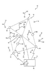
Figure 1 illustrates very broadly an embodiment of the emergency services
system 10
(hereinafter referred to "ESS 10"). The ESS 10 comprises a number of tags 12,
and
mesh network 14, and a management system 16. In brief, each person on the
worksite is provided with a tag 12. Each tag 12 when activated and logged onto
the
ESS 10 uniquely identifies the person carrying that tag. To this end the ESS10
and
tags 12 may use bionnetric recognition software to uniquely identify
personnel.
Example of such software include fingerprinting scanning software presently in
use at
airports or retina scanning software in operation in high security areas of
government
and/or military installations. The mesh network 14 comprises a number of nodes
18
and is arranged to provide communication over the entirety of the worksite.
The nodes
18 communicate with active tags 12. The management system 16 receives and
processes position data of active tags 12 from the nodes 18 via the
communications
CA 02851143 2014-04-04
WO 2013/033780
PCT/AU2012/001065
- 7 -
network 14. The management system 16 includes one or more displays arranged to
display information pertaining to a worksite, its personnel and status. The
information
may be displayed in numerous ways including but not limited to: 2D or 3D
graphical
representations and models of personnel and structures including section
views, and x-
ray or transparent views; real images in 2D or 3D; alpha-numerical data
including text,
graphs, and tables; and any combination thereof. Examples of the information
displayed include: real-time location (and thus tracking) of the tags 12 on
the worksite
(shown for example in Figure 2); sensed or detected data relating to the
personnel on
the worksite; and operational status of plant and equipment. It is envisaged
that the
management system 16 is co-located with a control centre for the worksite.
However
the, or an additional, duplicate management system 16 can be located remote
from the
worksite.
Figure 3 provides a representation of the management system 16. The management
system 16 is or may be equated with a control centre having a banks of
relatively large
screen commonly viewable displays 17 (as shown in Figure 2) and 19 providing
switchable views of the worksite; and operator consoles 21. The consoles 21
are
provided with dedicated display screens 23 and communications interfaces such
as a
keyboard, telephone and radio. The communications interfaces enable the
operator to
communicate with: worksite personnel on an individual, group, or a
regional/area basis;
or with offsite personnel or services.
Each tag 12 is in the form of an electronic device having at least a
transmitter but
preferably a transceiver to allow bi-directional communication of information
with the
network 14 and in particular, one or more of the nodes 18. Providing the tag
12 in the
form of an electronic device also enables easy coding of the tag 12 to
uniquely identify
a person carrying a tag and logging into the ESS 10. As an example in one
form, the
tag 12 may comprise or at least include the substantive features of a mobile
telephone
in terms of the ability to transmit and received information and provide
visual, audible
and tactile communication. The tag 12 is housed in a rugged and preferably
waterproof casing to provide protection commensurate with the nature of the
worksite
and work performed by persons carrying the tag 12. It is further envisaged
that the tag
12 in addition to communicating location data may also be provided with the
following
features:
= Push to talk communications for use within the worksite;
= Mobile chat/Twitter equivalent functionality for use within the
worksite;
CA 02851143 2014-04-04
WO 2013/033780
PCT/AU2012/001065
- 8 -
= Telephone communication routed through the phone system of the worksite;
= General purpose computing capability and optionally internet
functionality;
= Video camera support for recording or live sharing of worksite activities
with
remote viewers.
The tag 12 may be configured to be worn by or on a person. For example, tag 12
may
be of a shape and configuration to sit within a pocket on a garment of
clothing.
Alternatively, a dedicated pouch may be provided for the tag 12 to provide
additional
physical protection and enable coupling to a belt or other item of clothing
worn by the
person. In yet a further variation, the tag 12 may be embedded in or attached
to a
safety helmet, or in or on a shoe or boot. In a further variation the tag may
be provided
with or otherwise fixed to a clip wherein the clip is operable to clip onto a
person's
clothing or clothing accessory such as but not limited to a belt, tie, or
braces.
The tag 12 can also be arranged to communicate life signs to the management
system
16 such as one or more of: pulse rate, heart beat and electrocardiogram
signal. This
may be achieved by providing a sensor that is worn by a person and
communicates
with the tag. Such sensors are commonly available and used by athletes or
persons
during exercise to monitor heart rate.
The above described tags 12 may be considered as "smart" tags as they provide
user
functionality and two way communications and signalling. In addition or
alternately the
tag 12 may be "dumb" tags 12d. A dumb tag 12d can be either in the form of:
transponder which and only transmits signs in response to being interrogated
by an
electronic device; or a transceiver that that issue a very limited range of
signals such
as an "emergency" signal and/or a "location" signal. The dumb tag 12d does not
ordinarily have or need an onboard power supply. A person can be provided with
both
a smart tag 12 and a dumb tag 12d to provide a degree or redundancy.
Throughout
this description the term "tag 12" is used and to be understood in a generic
sense to
include smart or dumb tags unless the context of use implies otherwise.
As previously described, mesh network 14 comprises a number of nodes 18. Each
node is arranged to act as an independent router. This enables the
communications
network to re-configure itself in the event of a node 18 being disabled for
example due
to catastrophic event or loss of power. In such circumstances, the remaining
nodes 18
automatically reconfigure communication paths within the network 14 ensuring
end-to-
end communication between tags 12 and the management system 16 via the network
CA 02851143 2014-04-04
WO 2013/033780
PCT/AU2012/001065
-9-
14.
The nodes 18 may communicate with each other via wireless communication
channels. However, in alternate embodiments, nodes 18 may communicate with
each
other via a solid state communications medium such as dedicated cables, over
powerlines, or optical fibres. In a further variation a combination of
wireless and solid
state channels may be used to provide communication between nodes 18.
Moreover,
the nodes 18 may utilise pre-existing communications infrastructure of the
worksite to
facilitate information transferred between nodes 18.
Each node 18 may be both hard-wired to a worksite power supply or grid and
provided
with battery backup in an event of a disconnection from the worksite power
supply.
Each of the nodes may also be housed with a thermal and explosion resistant
housing
to provide shielding in the event of a catastrophic event in the worksite.
The above nodes can be considered as smart or active nodes in that they are
able to
automatically re-route communications in the event of loss communications with
another node and/or provided video and sensory capability. However in addition
one or
more "dumb" nodes 18d can be provided. The dumb nodes are enabled to
communicate with active tags in the worksite and provide corresponding
position data
relating to the active tag, as per a smart node. However in addition to this
the dumb
nodes act solely as signal relay devices and are unable to act as a router,
nor have
any sensing capabilities for environmental conditions, e.g. heat, smoke, gas
etc. Such
dumb nodes 18d may be positioned to provide one or more redundant
communications
paths particularly, though not exclusively in regions where the surrounding
infrastructure may make electronic signal communications difficult and/or of
lower than
required reliability. Throughout this description the term "node 18" is used
and to be
understood in a generic sense to include smart or dumb nodes unless the
context of
use implies otherwise.
With reference to Figure 4, in one embodiment a node 14 may be housed within
an exit
sign 20. The sign 20 comprises a housing 22 in which is disposed a plurality
of
illumination devices such as fluorescent light tubes 24 to provide lighting of
the exit
sign 20. Batteries may also be provided as a backup power supply for the
lighting
tubes 24. Node 14 is configured to fit within the housing 22. A small window
or cut-
away opening 26 is provided in a corner of the housing 22 at a position to
register with
one or more sensors and/or video or audio surveillance equipment which may be
CA 02851143 2014-04-04
WO 2013/033780
PCT/AU2012/001065
- 10 -
incorporated in the node 14. These additional features are discussed in
greater detail
below. The housing 22 is closed by a detachable side panel 28 which allows
quick and
easy access to the node 14.
Alternatively or additionally a node 18 may be installed or retro-fitted in a
conventional
emergency lighting system 31 as shown in Figure 5. A conventional emergency
lighting system usually comprises two mains powered floodlights 33 directed in
opposite directions mounted on a housing 35. A battery 37 in the housing 35
provides
back-up power to the lights 31 and node 18 in the event of mains power
failure.
Significantly however for the purposes of embodiments of the present invention
emergency lighting systems are often placed in corridors intermediate exit
signs. Thus
installation of the EES 10 in a worksite can be simplified by using a
combination of
both existing exit signs and emergency lighting systems to accommodate at
least some
nodes 18.
Incorporating the node 18 into an existing exit sign 20 and/or emergency
lighting
system is believed to provide synergistic benefits due to the existence of
battery
backup and the inherent location of such signs 20 and lighting systems. With
regard to
the latter, exit signs 20 are typically distributed across a worksite at all
locations where
people are ordinarily present and enter or leave the worksite or designated
areas
within a worksite, while emergency lighting systems are typically located in
corridors or
thoroughfares between entry and exits points of the worksite.
As previously mentioned, nodes 18 may also incorporate a range of sensors as
well as
video and/or audio surveillance equipment. The sensors sense different
physical
characteristics in an immediately adjacent region or environment. Examples of
physical characteristics sensed by the sensors include but are not limited to:
air
temperature, air pressure, moisture, smoke, fire, infrared radiation,
vibration, motion
and specific gases such as natural gas or methane. Information pertaining to
the
sensed characteristics is communicated via the associated node 18 and the mesh
network 14 to the management system 16. The management system is programmed
or otherwise configured to display the sensed data and raise alarms in the
event that
sensed data lies outside prescribed levels or ranges.
While it may be convenient for one or more of the sensors to be co-located
with a node
18, this is not a necessity. Numerous sensors may be located at positions
physically
separated from a node 18 but nonetheless in communication with one or more of
the
CA 02851143 2014-04-04
WO 2013/033780
PCT/AU2012/001065
-11 -
nodes 18.
The provision of video and/or audio surveillance allows operators at the
management
system 16 to view public areas of the worksite in real time. Additionally the
video and
audio data can be recorded on a recording system of the ESS10. The provision
of
such data also facilitates better critical decision making in an emergency
situations, for
example: cutting off power or ventilation to various areas; operating doors or
gates to
partition one or more parts of the worksite from others; and, directing
personnel away
from dangerous areas of the worksite.
An embodiment of the method of installing the ESS 10 relies on placing the
nodes 18
at locations based on observed signal strength. More particularly, in this
embodiment
the ESS 10 relies on use of signal strength in the mesh communication network
14 to
provide one source of location information. The observed signal strength
received to
multiple nodes 18 is used to triangulate the position of a tag 12. As part of
the
installation procedure an analysis of node placement in the physical worksite
is
conducted. This involves observing the signal strength at different locations
for all of
the nodes 18 reachable at that location and calibrating the signal strengths
in a
database of the management system 16 against positions within a three
dimensional
model of the worksite. The tags 12 may be arranged to transmit signal strength
information in addition, or as an alternative, to specific location
information as part of
their normal operation. The management system 16 then utilises information
stored in
the database of observed signal strength to determine location of a tag 12 and
thus a
person within the worksite. The location resolution provided by this is in the
order of 1
meter or less.
As mentioned above, the ESS 10 may incorporate a recording system to record
location of tags 12 (and thus people), video and audio data, and sensor data.
Indeed
duplicate recording systems or at least data storage duplicate of the recorded
data
may be provided at multiple separated locations. For example, a recording
system
may be located at the worksite itself, adjacent to the worksite and in a
remote
operation centre. The recorded data can be used in various scenarios including
but
not limited to:
1. In the event of an emergency occurring, emergency response personnel can
view location or relevant information for a period of time just before the
emergency occurred. This may provide important information to assist in the
CA 02851143 2014-04-04
WO 2013/033780
PCT/AU2012/001065
- 12 -
rescue of people in danger or to highlight the possibility of another
emergency
event in the near future.
2. In a catastrophic emergency scenario, significant portions of the worksite
may
be damaged and live information feeds from many or all of the nodes 18 may
not be available. In this scenario, the recorded data leading up to the event
can
be extrapolated by emergency response personnel to assist in decision making.
For example if a previously active tag 12 is no longer detected by the nodes
18,
then review of recorded data to determine the location of a person prior to
the
occurrence of the emergency can greatly assist in locating them.
3. Review of recorded data after an emergency event may also be used to assist
in streamlining and improving emergency response procedures.
The management system 16 may be programmed or otherwise configured to produce
alarms in the event of anomalous or undesirable events being detected. For
example
an alarm may be triggered by the management system 16 in the event of the
detection
of a person on the worksite without a corresponding active tag 12. Such may
occur for
example by the use of motion or infrared detectors. If such a person is
detected
without the detection of an active tag 12 at the same location, or a
difference in the
number of personnel and tags is detected, the existence of a person without a
tag 12
can be inferred. Also, a particular duty or function of persons with active
tags 12 can
be recorded by the management system 16. An alarm may be raised if a person
performing a designated function or task is located in an un-authorised area
of the
worksite. Further, alarms may be raised where persons with potentially
dangerous
conflicting tasks or functions are co-located. For example, it may be
undesirable to
have a welder and a painter or pipe repair personnel within a prescribed
distance of
each other due to the potential danger of sparks from a welder igniting paint
fumes or
fluids leaking from a pipe. Of course other alarms may be triggered in the
event that
one or more sensors detect physical characteristics outside of prescribed
levels or
ranges. For example a sensor detecting the presence of natural gas or methane
above a prescribed level can also trigger an alarm.
The ESS 10 incorporates one or more dynamically positionable nodes which can
be
deployed to supplement, or assist in repair of, the mesh network 14 for
example in the
event that one or more fixed nodes become disabled. As suggested above one or
more of the dumb nodes 18d may also be used for this purpose.
CA 02851143 2014-04-04
WO 2013/033780
PCT/AU2012/001065
- 13 -
The dynamically positionable nodes may be supported by a variety of unmanned
node
vehicles or UNVs 41,43 as shown in Figure 6. One example of a UNV is a
remotely
controlled wheeled or tracked robot 41. The robot can be moved by remote
controlled
to a location to communicate with one or more active nodes to reconstitute or
augment
the mesh network 14. A further example of a UNV is a remote controlled flying
vehicle
such as a quad copter 43. Quad copters 43 are known as being very stable
remotely
controlled airborne vehicles which can be manoeuvred into and through tight
passages.
One or more of the nodes may also be installed in escape vehicles associated
with the
worksite. For example, Fig. 2 illustrates, in a transparent or x-ray mode a
worksite in
the form an offshore oil rig. The rig contains a number of escape pods or
vessels 40.
The communications network 14 includes a node 18 in each of the vessels 40.
The
nodes in the vessels 40 are ordinarily active and communicate with the
management
system 16 via the associated communications network 14. In a case of an
emergency
where people are being evacuated in one of the vessels 40, the node 18 in that
vessel
continues to communicate either via the communications network 14 with
management
system 16; or directly to the management system 16. Consequently the
identification
of people wearing active tags within the vessel 40 can be viewed via the
management
system 16 and logged on the recording system.
Now that an embodiment of the present invention has been described in detail
it will be
apparent to those skilled in the relevant arts that numerous modifications and
variations may be made without departing from the basic inventive concepts.
For
example, the system 10 is not limited to use on an oil rig and may be used in
any other
worksite. Further, the specific technology used for communication between
nodes 18
or more broadly throughout the mesh network 14 is not critical and may
comprise a
mixture of known communication technologies and protocols. Further, the ESS 10
may be incorporated in a control system for the worksite where the data input
and
visualised in the management system can be used to provide feedback on the
operational status of the worksite. This in turn can enable operators of the
control
centre to exert control over equipment in the worksite. Further the ESS 10 may
incorporate multiple management systems 16, a first being on the worksite with
one or
more duplicate management systems located remote from the first management
system. It is envisaged that the at least one of the duplicate sites is not
only remote
from the first management system but moreover remote from the worksite. This
CA 02851143 2014-04-04
WO 2013/033780
PCT/AU2012/001065
- 14 -
provides redundancy in the event of a catastrophic event which disables a
first (onsite)
management system. When a duplicate management system is provided the first
management system and the mesh network are arranged to independently
communicate with the duplicate management system to enable operators at the
duplicate system to continue to monitor the worksite.
In yet a further variation each tag 12 can be provided with an integrated GPS
device
and the management system is arranged to track the tags 12 using the GPS
directly to
provide a secondary mechanism for tracking people with active tags. As the
management system 16 directly tracks the tags 12 via the corresponding GPS
device,
tracking information is available to operators at the management system(s) in
the event
that position information/data is not communicated via the mesh network.
Circumstances when this may occur include a person falling off an offshore rig
and
moving outside the communication range of the mesh network, or a catastrophic
event
occurs of such a scale to totally disable the mesh network and/or the on site
management system. In the latter case GPS tracking is available at duplicate
remote
management systems.
All such modifications and variations are deemed to be within the scope of the
present
invention the nature of which is to be determined from the above description
and the
appended claims.