Note: Descriptions are shown in the official language in which they were submitted.
CA 02852428 2014-05-28
,
WASTE STREAM MANAGEMENT SYSTEM AND METHOD
BACKGROUND
[1] The inventive concepts disclosed herein are generally directed to
waste stream management systems. More particularly, but not by way of
limitation,
the inventive concepts disclosed herein are directed to a waste stream
management
system for controlled land application of contaminants from waste stream
fluids.
[2] Multiple human activities produce waste streams which include various
contaminants at varying concentrations, and which are managed in various
manners.
For example, municipalities produce waste streams (e.g., sewage), that include
fluids which are typically processed and/or treated before being returned to
the
environment. Further, industrial and agricultural operations generate varying
contaminant concentration waste streams that likewise are processed or treated
to
minimize the environmental effects of the contaminants contained therein. For
example, waste streams from paper mills, industrial facilities, poultry
processing
plants, slaughter houses, and other industrial, agricultural, or municipal
sources
include contaminants at varying concentrations, and the particular
contaminants
present in a waste stream and their respective concentrations generally guide
the
appropriate method of management of the waste stream.
[3] The oil and gas industry produces multiple waste streams at various
stages of oil and gas well development and exploitation, which include water-
based
fluids and/or solids such as drilling mud and flowback water, oil-based fluids
and
solids, and other similar waste streams, which are disposed of in compliance
with a
variety of environmental regulations. For example, prior art oilfield waste
stream
management practice has been to deposit used drilling mud into a mud pit at
the well
site, where the drilling mud is simply encased in a layer of dirt after the
well is
1
CA 02852428 2014-05-28
completed. The encased drilling mud remains at that location indefinitely,
increasing
the potential for contamination of adjacent soils, and surface and subsurface
waters.
[4] In recent years, due to increasing environmental concerns and
strict
legislative regulation and oversight, conventional industrial, municipal, and
agricultural waste stream management practices have faced increased scrutiny,
and
multiple improvements and changes to such practices have been proposed and/or
mandated to protect the environment.
[51 One such proposed waste stream management practice has been to
apply waste streams on a tract of land to spread the contaminant(s) present in
the
waste stream over a land area such that the concentration of contaminants per
area
of land is well below safe levels for each contaminant as set by applicable
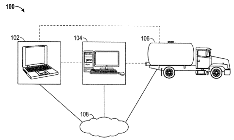
laws or
regulations. In some instances, the land application of waste streams not only
does
not harm the land area or soil onto which the waste stream has been applied,
but
actually improves the usability of the tract of land as agricultural land.
[6] Several systems have been recently proposed to apply waste streams
to land. For example, the system described in U.S. Publication No.
2011/0266357,
the entire disclosure of which is hereby expressly incorporated herein by
reference,
uses a constant flowrate on/off 4-inch valve, which is opened when an
applicator
vehicle is moving above a predetermined minimum speed, so that a rate of
application when the valve is opened and when the applicator vehicle is moving
above the predetermined minimum speed does not exceed a predetermined
maximum application rate.
[7] However, applying waste streams at a constant flowrate is generally
suboptimal, as such application may result in applying a lower level of
contaminants
than allowed by applicable regulations by not fully utilizing the available
area of land,
2
CA 02852428 2014-05-28
thus leaving a substantial unused contaminant loading capacity in the land
area.
Further, in some instances where the predetermined minimum speed cannot be
achieved or maintained by the applicator vehicle (e.g., when the applicator
vehicle
moves up or down a hill, and/or over slippery or rough terrain) the
application is
discontinued for any periods of time when the applicator vehicle is moving
below the
predetermined minimum speed. This results in significant loss of time for the
operator of the applicator unit. Simply driving the applicator vehicle over
the land
area without applying waste stream fluids unnecessarily increases the land
area
needed to manage a given volume of waste stream fluids and the overall waste
stream application times, and results in increased fuel and other costs.
Finally,
requiring the applicator vehicle to move at or above a predetermined minimum
speed
over rough terrain increases applicator vehicle maintenance costs and
downtime.
[8]
Further, applying waste streams at constant flowrates limits the
usability of the applicator vehicle where the concentrations of contaminants
vary over
time or per each load of waste stream fluids, such as when a live waste stream
has
to be managed which is often the case in oil and gas operations. For example,
when
the level of contaminants in a particular load of waste stream fluids from a
live waste
stream is higher than expected, applying at a constant rate may not be
feasible, as
the applicator vehicle may be unable to achieve a high enough speed to apply
the
waste stream at an acceptable application rate. Further, when the level of
contaminants in a particular load of waste stream fluids from a live waste
stream is
lower than expected, applying at a constant rate at the predetermined minimum
speed would leave a significant contaminant capacity in the land area and
significantly underutilize the available land area. Managing a waste stream
with
variable contaminant concentrations with constant flowrate application systems
may
3
CA 02852428 2014-05-28
k
result in inaccurate measurement of the actual amount of contaminant applied
to the
land area, which would make repeated applications on the same land area
extremely
risky and/or practically impossible.
SUMMARY
[9] In one aspect, the inventive concepts disclosed herein are directed to
an applicator unit for applying waste stream fluids containing a contaminant
to a land
area. The applicator unit may include a movable container configured to hold a
volume of waste stream fluids including a contaminant, and a diffuser. A valve
assembly may include a conduit fluidly coupled with the movable container and
configured to direct a volume of fluids to the diffuser, a variable flowrate
valve
operably coupled with the conduit, and an actuator operably coupled with the
variable flowrate valve and configured to selectively and incrementally open
and
close the variable flowrate valve in response to receiving at least one
control signal.
A controller may include a location signal receiver configured to receive a
signal
indicative of a geospatial location of the of the movable container relative
to a land
area, a non-transitory computer readable medium storing processor executable
code
and a contaminant capacity profile of the land area indicative of an amount of
the
contaminant to be applied to the land area, and a processor operably coupled
with
the location signal receiver and with the non-transitory computer readable
medium
storing processor executable code, wherein the processor executable code, when
executed by the processor, causes the processor to control the actuator to set
the
variable flowrate valve at a predetermined position based at least partially
on the
geospatial location of the movable container and the contaminant capacity
profile.
[10] The contaminant capacity profile may include an exclusion zone in the
land area where no waste stream fluids are to be applied, and the processor
may
4
CA 02852428 2014-05-28
transmit a control signal to the actuator directing the actuator to close the
variable
flowrate valve so as to prevent waste stream fluids from being applied in the
exclusion zone.
[11] The valve assembly may also include a flowmeter operably coupled
with the conduit upstream of the variable flowrate valve. The flowmeter may be
operably coupled with the controller and may be configured to detect a volume
of
waste stream fluids flowing through the flowmeter, and to output a signal
indicative of
the volume of waste stream fluids flowing through the flowmeter. The processor
executable code may further cause the processor to receive the signal and to
update
the contaminant capacity profile of the land area based on the volume of waste
stream fluids applied to the land area.
[12] The valve assembly may also include a flowmeter operably coupled
with the conduit upstream of the variable flowrate valve, and operably coupled
with
the controller. The flowmeter may be configured to detect a volume of waste
stream
fluids flowing through the flowmeter, and to output a first signal indicative
of the
volume of waste stream fluids flowing through the flowmeter. A first control
module
may be operably coupled with the flowmeter, the actuator, and the controller,
and
may be configured to receive the first signal, quantify the volume of fluids
flowing
through the flowmeter, and to transmit a second signal indicative of the
volume of
waste stream fluids flowing through the flowmeter to the controller. A second
control
module may be operably coupled with the flowmeter, the actuator, and the
controller,
and may be configured to receive the first signal, quantify an amount of the
contaminant flowing through the flowmeter, and transmit a third signal
indicative of
the amount of the contaminant flowing through the flowmeter. The processor
executable code may further cause the processor to receive the second and
third
CA 02852428 2014-05-28
,
signals and to update the contaminant capacity profile of the land area based
on the
volume of waste stream fluids applied to the land area and/or the amount of
the
contaminant applied to the land area.
[13] The fluid conduit may include a substantially straight portion
positioned
upstream of the flowmeter and configured so that fluids flowing through the
substantially straight portion of the conduit enter the flowmeter in a
substantially
laminar fashion. The flowmeter may be a magnetically induced flow meter.
[14] The amount of the contaminant applied to the land area may be
expressed as weight of the contaminant per area, and/or the amount of waste
stream fluids may be expressed in volume per area.
[15] The processor may transmit a control signal to the actuator by: (a)
transmitting a volume control signal to the first control module indicative of
a total
volume of waste stream fluids to be applied to the land area, and (b)
transmitting a
contaminant amount control signal to the second control module indicative of a
total
amount of the contaminant to be applied to the land area. The first control
module
may transmit a first control signal to the actuator and the second control
module may
transmit a second control signal to the actuator directing the actuator to
incrementally open, close, or maintain a current position of the variable
flowrate
valve.
[16] The controller may also include a wireless transceiver, and the
processor executable code may further cause the processor to receive a
wireless
signal indicative of an amount of the contaminant applied to the land area by
a
second applicator unit and a geospatial location of the applied amount of the
contaminant in the land area, and to update the contaminant capacity profile
of the
land area based on the amount of the contaminant applied to the land area by
the
6
CA 02852428 2014-05-28
second applicator unit. The processor executable code may further cause the
processor to transmit a wireless signal indicative of the total amount of the
contaminant applied to the land area via the wireless transceiver.
[17] In another aspect, the inventive concepts disclosed herein are
directed
to a control center for a contaminant management system, including a computer
system having a processor and a non-transitory computer readable medium
storing
processor executable code, which when executed by the processor, causes the
processor to: (a) receive via a computer port a first signal from a computer
network
indicative of a land area to which a volume of waste stream fluids containing
a
contaminant is to be applied; (b) access data indicative of a contaminant
profile of
the contaminant in the land area; (c) access data indicative of a maximum
allowable
amount of the contaminant in the land area; and (d) generate a contaminant
capacity
profile of the land area indicative of an amount of the contaminant to be
applied to at
least a portion of the land area based at least in part on the contaminant
profile and
the maximum allowable amount of the contaminant in the land area.
[18] The processor executable code may further cause the processor to
transmit a signal indicative of the contaminant capacity profile to a remote
applicator
unit over the computer network.
[19] The processor executable code may further causes the processor to:
(e) receive a fourth signal over the computer network, the fourth signal
indicative of
an amount of the contaminant applied to the land area by a remote applicator
unit;
and (f) update the contaminant capacity profile of the contaminant in the land
area
based on an amount of contaminant applied to the land area.
7
CA 02852428 2014-05-28
[20] The processor executable code may further cause the processor to
store the updated contaminant capacity profile of the contaminant in the land
area in
a non-transitory computer readable medium.
[21] In a further aspect, the inventive concepts disclosed herein are
directed
to a scouting unit for a waste stream management system. The scouting unit may
include a location signal receiver configured to receive a signal indicative
of a
geospatial location of the location signal receiver relative to a land area,
and a
processor operably coupled with a non-transitory computer medium storing
processor executable code, which when executed by the processor causes the
processor to: (a) map one or more georeferenced points indicative of a
perimeter
including a portion of the land area on which a volume of fluids including a
concentration of a contaminant is to be applied; (b) determine at least one
soil
sampling location for an existing level of the contaminant in the portion of
the land
area in the perimeter; and (c) map one or more georeferenced points indicative
of at
least one exclusion zone where the volume of fluids including the contaminant
is not
to be applied.
[22] The scouting unit may also include an input device, and the processor
executable code, when executed by the processor, may cause the processor to
receive input from a user, indicative of one or more user-designated
georeferenced
points indicative of a user-designated exclusion zone at least partially in
the
perimeter where no volume of fluids is to be applied, and exclude the user-
designated exclusion zone from the perimeter.
[23] The scouting unit may also have a transceiver operably coupled with a
computer network, and the processor executable code, when executed by the
processor, may cause the processor to transmit a signal over the computer
network
8
CA 02852428 2014-05-28
,
indicative of the one or more georeferenced points indicative of the perimeter
of the
land area and/or a signal over the computer network indicative of the one or
more
georeferenced points indicative of the at least one exclusion zone.
[24]
In yet another aspect, the inventive concepts disclosed herein are
directed to a contaminant management system. The system may include a scouting
unit including a signal receiver configured to receive a signal indicative of
a
geospatial location of the scouting unit relative to a land area, at least one
processor,
and a non-transitory computer readable medium storing processor executable
code,
which when executed by the processor, causes the processor to map one or more
georeferenced points indicative of a perimeter including a portion of the land
area
where a volume of fluids including a concentration of a contaminant is to be
applied,
and to transmit a first signal over a computer network indicative of the one
or more
georeferenced points indicative of the perimeter. The system may also include
a
control center including a processor and a non-transitory computer readable
medium
storing processor executable code, which when executed by the processor,
causes
the processor to: (a) receive the first signal via a computer port coupled
with the
computer network; (b) access data indicative of a contaminant profile of the
at least
one contaminant in the portion of the land area in the perimeter; (c) access
data
indicative of a maximum allowable amount of the contaminant in the portion of
the
land area in the perimeter; and (d) generate a contaminant capacity profile
for the
portion of the land area in the perimeter based at least in part on the
contaminant
profile of the contaminant in the portion of the land area in the perimeter
and the
maximum allowable amount of the contaminant in the portion of the land area in
the
perimeter.
9
CA 02852428 2014-05-28
[25] The system may also have an applicator unit including a movable
container, a valve assembly including a variable flowrate valve and an
actuator
operably coupled with the variable flowrate valve and configured to
incrementally
open, close, or maintain a position of the variable flowrate valve, and a
controller
operably coupled with the actuator. The controller may include a location
signal
receiver configured to receive a signal indicative of a geospatial location of
the
applicator relative to the land area, a processor, and a non-transitory
computer
readable medium coupled with the at least one processor and storing processor
executable code which when executed by the processor, causes the processor to
access the contaminant capacity profile, access data indicative of a
concentration of
the at least one contaminant in a volume of fluids loaded in the movable
container;
and provide a control signal to the actuator to cause the actuator to
incrementally
open or close, or maintain the position of the variable flowrate valve based
at least
partially on the geospatial location of the applicator relative to the land
area.
[26] The contaminant capacity profile may include at least one exclusion
zone where no waste stream fluids are to be applied, and the controller may
cause
the actuator to close the variable flowrate valve in response to the movable
container
being in the at least one exclusion zone.
[27] In a further aspect, the inventive concepts disclosed herein are
directed
to a method for managing a live stream of waste stream fluids. The method may
include: (a) loading a first volume of waste stream fluids including a first
concentration of a contaminant in a first applicator unit configured to apply
waste
stream fluids to a land area; (b) accessing, by a controller of the applicator
unit, data
indicative of the first concentration of a contaminant in the volume of waste
stream
fluids loaded in the first applicator unit; (c) accessing, by the controller
of the
CA 02852428 2014-05-28
,
applicator unit, a contaminant capacity profile indicative of an amount of the
contaminant to be applied in the land area; (d) applying at least a portion of
the
volume of waste stream fluids loaded in the application unit on at least a
portion of
the land area based on the first concentration of the contaminant in the
volume of
waste stream fluids and the contaminant capacity profile; and (e) generating,
by the
controller of the applicator unit, an updated contaminant capacity profile
based at
least in part on the volume of waste stream fluids applied on the land area
and the
first concentration of the contaminant in the volume of waste stream fluids
applied to
the land area.
[28]
The method may also include: (f) loading a second volume of waste
stream fluids including a second concentration of the contaminant onto a
second
applicator unit; (g) accessing, by a controller of the second applicator unit,
data
indicative of the second concentration of the contaminant in the volume of
waste
stream fluids loaded in the second applicator unit; (h) accessing, by the
controller of
the second applicator unit, data indicative of the updated contaminant
capacity
profile from the first applicator unit; and (i) applying at least a portion of
the volume of
waste stream fluids loaded in the second applicator unit on at least a portion
of the
land area, based on the second concentration of the contaminant in the volume
of
waste stream fluids and the updated contaminant capacity profile. The second
concentration and the first concentration are different from one another. The
data
indicative of the second concentration of the at least one contaminant in the
volume
of waste stream fluids loaded in the first applicator unit may be obtained by
field-
testing the concentration of the at least one contaminant in the volume of
waste
stream fluids loaded in the first applicator unit.
11
CA 02852428 2014-05-28
[29] In
yet another aspect, the inventive concepts disclosed herein are
directed to an applicator unit for applying waste stream fluids containing at
least one
contaminant to a land area. The applicator unit may include a movable
container
configured to hold a volume of waste stream fluids including at least one
contaminant, a diffuser, a valve assembly including a conduit fluidly coupled
with the
movable container and configured to direct a volume of fluids to the diffuser,
a
variable flowrate valve operably coupled with the conduit, and an actuator
operably
coupled with the variable flowrate valve and configured to selectively and
incrementally open and close the variable flowrate valve in response to
receiving at
least one control signal. A soil analyzer may be associated with the movable
container and may be configured to measure a level of the at least one
contaminant
in a land upstream of the diffuser, and to output a signal indicative of the
level of the
at least one contaminant in the land area. A controller may include a non-
transitory
computer readable medium storing processor executable code and data indicative
of
a maximum allowable amount of the at least one contaminant in the land area,
and
at least one processor operably coupled with the non-transitory computer
readable
medium storing processor executable code, wherein the processor executable
code,
when executed by the at least one processor, causes the at least one processor
to
receive the signal indicative of the level of the at least one contaminant in
the land
area and control the actuator to set the variable flowrate valve at a
predetermined
position based at least partially on the maximum allowable amount of the at
least
one contaminant in the land area and the level of the at least one contaminant
in the
land area measured by the soil analyzer.
BRIEF DESCRIPTION OF THE DRAWINGS
12
CA 02852428 2014-05-28
[30] The accompanying drawings, which are incorporated in and constitute
a part of this specification, illustrate one or more implementations described
herein
and, together with the description, explain these implementations. Like
reference
numerals in the figures represent and refer to the same element or function.
In the
drawings:
[31] FIG. 1 is a general overview of an exemplary embodiment of a waste
stream management system according to the inventive concepts disclosed herein.
[32] FIG. 2 is a diagram of a scouting unit of the waste stream management
system of FIG. 1.
[33] FIG. 3 is a diagram of an exemplary embodiment of a perimeter and an
exclusion zone mapped in a land area by the scouting unit according to the
inventive
concepts disclosed herein.
[34] FIG. 4 is a diagram of an exemplary embodiment of a soil sampling
grid for the land area of FIG. 3 generated by the scouting unit according to
the
inventive concepts disclosed herein.
[35] FIG. 5 is a diagram of a control center of the waste stream
management system of FIG. 1.
[36] FIG. 6 is a diagram of an exemplary embodiment of a contaminant
profile of the land area of FIG. 3 according to the inventive concepts
disclosed
herein.
[37] FIG. 7 is a diagram of an exemplary embodiment of the contaminant
profile of FIG. 6 shown as derived total dissolvable solids amounts.
[38] FIG. 8 is diagram of an exemplary embodiment of a contaminant
capacity profile of the land area of FIG. 3.
13
CA 02852428 2014-05-28
[39] FIG. 9 is a diagram of an exemplary embodiment of an applicator unit
of the waste stream management system of FIG. 1.
[40] FIG. 10 is an exemplary screenshot showing application rate
monitoring by the applicator unit of FIG.9.
[41] FIG. 11 is an exemplary screenshot showing perimeter control by the
applicator unit of FIG. 9.
[42] FIG. 12 is an exemplary screenshot showing exclusion zone control by
the applicator unit of FIG. 9.
[43] FIG. 13 is an exemplary screenshot showing overlap control by the
applicator unit of FIG. 9.
[44] FIG. 14 is an exemplary log profile of applied volume of waste stream
fluids according to the inventive concepts disclosed herein.
[45] FIG. 15 is an exemplary embodiment of a log profile of applied amount
of contaminant according to the inventive concepts disclosed herein.
DETAILED DESCRIPTION OF EXEMPLARY EMBODIMENTS
[46] Before explaining at least one embodiment of the inventive concepts
disclosed herein in detail, it is to be understood that the inventive concepts
are not
limited in their application to the details of construction and the
arrangement of the
components or steps or methodologies set forth in the following description or
illustrated in the drawings. The inventive concepts disclosed herein are
capable of
other embodiments, or of being practiced or carried out in various ways. Also,
it is to
be understood that the phraseology and terminology employed herein is for the
purpose of description and should not be regarded as limiting the inventive
concepts
disclosed and claimed herein in any way.
14
CA 02852428 2014-05-28
[47] In the following detailed description of embodiments of the inventive
concepts, numerous specific details are set forth in order to provide a more
thorough
understanding of the inventive concepts. However, it will be apparent to one
of
ordinary skill in the art that the inventive concepts within the instant
disclosure may
be practiced without these specific details. In other instances, well-known
features
have not been described in detail to avoid unnecessarily complicating the
instant
disclosure.
[48] As used herein, the terms "comprises," "comprising," "includes,"
"including," "has," "having," and any variations thereof, are intended to
cover a non-
exclusive inclusion. For example, a process, method, article, or apparatus
that
comprises a list of elements is not necessarily limited to only those
elements, and
may include other elements not expressly listed or inherently present therein.
[49] Unless expressly stated to the contrary, "or" refers to an inclusive
or
and not to an exclusive or. For example, a condition A or B is satisfied by
anyone of
the following: A is true (or present) and B is false (or not present), A is
false (or not
present) and B is true (or present), and both A and B are true (or present).
[50] In addition, use of the "a" or "an" are employed to describe elements
and components of the embodiments disclosed herein. This is done merely for
convenience and to give a general sense of the inventive concepts. This
description
should be read to include one or at least one and the singular also includes
the plural
unless it is obvious that it is meant otherwise.
[51] As used herein, qualifiers like "substantially," "about,"
"approximately,"
and combinations and variations thereof, are intended to include not only the
exact
amount or value that they qualify, but also some slight deviations therefrom,
which
CA 02852428 2014-05-28
may be due to manufacturing tolerances, measurement error, wear and tear,
stresses exerted on various parts, and combinations thereof, for example.
[52] As used herein, the terms "waste stream" and "waste stream fluid(s)"
are intended to include a waste stream produced by an agricultural, municipal,
industrial, or other process or source including at least one contaminant, and
includes fluids (e.g., gasses and vapors) and solids (e.g., sediment, soil,
sand, clay,
solid chemicals, compost, and other solids, which may be dissolved, dispersed,
suspended, or otherwise mixed with fluids.
[53] As used herein the term "contaminant" is intended to include any
pollutant, impurity, toxin, constituent, compound, ion, molecule, salt,
poisonous
substance, or chemical, which is toxic or otherwise detrimental to a living
organism
(e.g., plants, animals, microorganisms, humans) within a waste stream, and for
which a maximum allowable level, concentration, or amount, within soil, land
area, or
water, may be established by an agreement (e.g., with a landowner), or by a
governmental or municipal body or agency.
[54] As used herein the term "profile" is intended to include a summary or
analysis of data representing distinctive features or characteristics. The
profiles
described herein can be a geographic information system (GIS) layer applied to
a
section of a map.
[55] Finally, as used herein any reference to "one embodiment" or "an
embodiment" means that a particular element, feature, structure, or
characteristic
described in connection with the embodiment is included in at least one
embodiment.
The appearances of the phrase "in one embodiment" in various places in the
specification are not necessarily all referring to the same embodiment.
16
CA 02852428 2014-05-28
[56] The inventive concepts disclosed herein will be described in detail in
connection with managing an oilfield waste stream including drilling mud by
controlled application of waste stream fluids to a land area, the instant
inventive
concepts may be applied to waste stream management by land application of any
desired waste stream fluids including one or more contaminants. For example,
waste
stream fluids including municipal sewage, animal manure, industrial waste
streams,
agricultural waste streams, or combinations thereof, may be applied to any
suitable
land area using a system and method according to the inventive concepts
disclosed
herein.
[57] A waste stream management system according to exemplary
embodiments of the inventive concepts disclosed herein may include a scouting
unit,
a control center, and an applicator unit, which may cooperate with one another
to
determine a contaminant profile of a land area, calculate a contaminant
capacity
profile of one or more separate regions within a land area (e.g., within a
predetermined perimeter), determine a contaminant concentration and/or content
in
a volume of waste stream fluids to be applied to an individual region of the
separate
regions of the land area, and apply a volume of the waste stream fluids to the
region
of the land area based at least in part on the contaminant capacity profile of
the land
area and the contaminant concentration and/or in the volume of waste stream
fluids
to be applied to the land area.
[58] Exemplary embodiments of the inventive concepts disclosed herein
provide a waste stream management system and method, which take into account
land area specific contaminant sampling and/or other information (e.g.,
gathered via
a scouting unit), land area specific contaminant capacity profile (e.g.,
developed by a
control center), and a waste stream fluids characterization process (e.g.,
carried out
17
CA 02852428 2014-05-28
by a lab and/or by an applicator unit), to control the application of waste
stream fluids
to the land area designed to be within preset maximum contaminant levels in
the
land area.
[59] Land area-specific criteria may be derived from land area
investigation
by a user of a scouting unit, and may be used to design buffer zones, to make
ecosystem determinations (e.g., where the ecosystem contaminant limit is lower
than
the regulatory contaminant limit), identify environmentally or hydrologically
sensitive
areas (exclusion zones), determine sampling locations to measure preexisting
amounts of contaminant in the soil and/or the land area (e.g., by soil
sampling) to
derive a contaminant profile for the land area, and map one or more
georeferenced
points indicative of a perimeter defining and/or including an acceptable waste
stream
fluid application portion or zone of the land area and/or at least one
exclusion zone.
This information may be transmitted to a control center (e.g., a computer
system
equipped with environmental guidance software) for development of a
contaminant
capacity profile for the portion of the land area in the perimeter that
governs waste
stream fluids application, by managing a most limiting contaminant, and
exclusion
zones in the land area where no waste stream fluids are to be applied. The
contaminant capacity profile may be determined by designating at least one
contaminant within the waste stream fluids as the limiting contaminant in
accordance
with a regulatory standard, a landowner/tenant agreed-upon standard, a
customer
standard, or an ecosystem standard, or combinations thereof, for example.
[60] The contaminant capacity profile may be transmitted or otherwise
provided to an applicator unit, which may operate based at least partially of
the
contaminant capacity profile, and may not exceed the parameters set by the
contaminant capacity profile (e.g., may not apply waste stream fluids outside
the
18
CA 02852428 2014-05-28
portion of the land area in the perimeter and/or into exclusion zones, and may
not
apply an amount of contaminant exceeding the amount set by the contaminant
capacity profile).
[61] In some cases, the applicator unit may be supplied with waste stream
fluids characteristics for each load of waste stream fluids it is loaded or
otherwise
provided with, including the concentration (e.g., density per volume) or
amount of at
least one contaminant present in the load of waste stream fluids from
appropriate lab
or field testing (e.g., per batch of waste stream fluids and/or by field
testing each load
of waste stream fluids in the applicator unit to determine the amount of
contaminant
present therein). A controller of the applicator unit may use this information
to
determine a set of current application rules, including correct application
rates for
each load of waste stream fluids provided to the applicator unit. Each
applicator unit
may log or record the total volume of waste stream fluids applied (e.g.,
substantially
in real time), the total amount of contaminant applied, and the geospatial
location
where the waste stream fluids were applied, and may provide application
oversight
to prevent or substantially eliminate noncompliance-related events.
[62] A log profile or record of the applied amount of contaminant may be
provided (e.g., transmitted over a computer network) to the control center
(e.g., in
real time as the application takes place) and/or to one or more other
applicator units
in the field, which allows for contaminant profile capacity updates to occur
substantially in real time as waste stream fluids and/or contaminant are
applied to a
land area. The resulting contaminant/soil mixture can be recreated in an
updated
contaminant profile and/or an updated contaminant capacity profile for the
land area
to allow for compliance reporting and, in some cases, for one or more other
19
CA 02852428 2014-05-28
(secondary) application if any portions of the land area have remaining
contaminant
capacity.
[63] Referring now to the drawings, and to FIG. 1 in particular, shown
therein is an exemplary embodiment of a waste stream management system 100
according to the inventive concepts disclosed herein, which may include at
least one
scouting unit 102, a control center 104, and at least one applicator unit 106,
configured to communicate data to one another over a network 108. As will be
appreciated by persons of ordinary skill in the art, in some exemplary
embodiments
the scouting unit 102 and/or the control center 104 may be omitted, and their
respective functions may be implemented by an applicator unit 106 having the
functionality according to the inventive concepts disclosed herein.
[64] The network 108 may be implemented as any desired computer
network permitting bi-directional communication and/or exchange of signals
and/or
data between the at least one scouting unit 102, the control center 104, and
the at
least one applicator unit 106, such as the Internet, a cellular network, an
optical
network, a satellite network, a wireless network, a 3G network, a 4G network,
a local
area network, an intranet network, a virtual private network, and combinations
thereof, and may utilize any desired networking protocol, such as TCP/IP, for
example.
[65] Referring now to FIG. 2, the scouting unit 102 may include at least
one
processor 110 operably coupled with a non-transitory memory 112 storing
processor
executable code, a location signal receiver 114, at least one I/O port 116, an
input
device 118, and an output device 120. The processor 110 may be configured to
communicate with the control center 104 and/or with the applicator unit 106 by
exchanging one or more signals (e.g., wired, wireless, electrical, or optical)
with the
CA 02852428 2014-05-28
control center 104 and/or with the applicator unit 106 via the I/O port 116
and the
network 108, for example. In some exemplary embodiments, the scouting unit 102
may be configured to dock or otherwise interface with the applicator unit 106
and/or
with the control center 104, such as via a designated dock (not shown),
wirelessly,
and/or via a wire of a cable, as will be appreciated by persons of ordinary
skill in the
art having the benefit of the instant disclosure. The scouting unit 102 can be
implemented as any desired portable device, such as a personal computer, a
smartphone, a laptop, a netbook, a tablet, an e-book reader, a network-capable
handheld device, a digital video recorder, a rugged outdoor computing device,
and
combinations thereof, for example.
[66] The
processor 110 may be implemented as a single processor or
multiple processors working together to execute the logic and/or processor
executable code described herein. Exemplary embodiments of the processor 110
include a digital signal processor (DSP), a central processing unit (CPU), a
field
programmable gate array (FPGA), a microprocessor, a multi-core processor, and
combinations thereof. The processor 110 is capable of communicating with the
memory 112 via a path 122 which can be implemented as a data bus, for example.
The processor 110 is capable of communicating with the input device 118 and
the
output device 120 via paths 124 and 126 including one or more data busses, for
example. The processor 110 may communicate with the I/O port 116 via a path
128,
which may be a data bus. It is to be understood that in certain embodiments
using
more than one processor 110, the one or more processors 110 may be located
remotely from one another, located in the same location, or comprising a
unitary
multi-core processor 110 (not shown). The processor 110 is capable of reading
21
CA 02852428 2014-05-28
and/or executing processor executable code and/or of creating, manipulating,
altering, and storing data structures into the memory 112.
[67] The memory 112 stores data and processor executable code in the
form of software and/or firmware, which includes processor executable code
written
in any suitable programming language, such as C++. The memory 112 may be
implemented as any non-transitory computer-readable medium, such as random
access memory (RAM), a CD-ROM, a hard drive, a solid state drive, a flash
drive, a
memory card, a DVD-ROM, a floppy disk, an optical drive, and combinations
thereof,
for example. While the memory 112 can be located in the same physical location
as
the scouting unit 102, the memory 112 may be located remotely from the
scouting
unit 102 and may communicate with the processor 110 via the I/O port 116
and/or
the network 108. Additionally, when more than one memory 112 is used, one or
more memory 112 may be located in the same physical location as the scouting
unit
102, and one or more memory 112 may be located in a remote physical location
from the scouting unit 102. The physical location of the memory 112 can be
varied,
and the memory 112 may be implemented as a "cloud memory" e.g., a memory 112
which is partially, or completely based on or accessed using the network 108.
[68] The location signal receiver 114 may include an antenna 130, and may
be configured to receive a geospatial location signal indicative of the
geospatial
location, elevation, coordinates, pitch, yaw, tilt, and/or speed of the
scouting unit 102
(e.g., from multiple global positioning satellite 132 and/or from multiple
cellular phone
towers 134), and/or from any other desired geospatial location signal source
such as
from any suitable global navigation, geospatial location, or positioning
system, such
as GPS, LORAN, GNSS, a cellular network tower, or any other desired source
indicative of a geospatial location or position of the location signal
receiver 114,
22
CA 02852428 2014-05-28
including latitude, longitude, and elevation, for example.. In some exemplary
embodiments, the location signal receiver 114 may be able to determine its
geospatial location on the Earth with sub meter accuracy (e.g., accuracy to
less than
1 meter).
[69] The I/O port 116 may be implemented as a physical and/or virtual
computer port (e.g., an electrical or optical port), and may be configured to
provide
an interface between the processor 110 and the network 108 so that the
processor
110 may transmit one or more signals indicative of information to the network
108,
and so that the processor 110 may receive one or more signals indicative of
information from the network 108, for example. In some embodiments, the I/O
port
116 may include a wireless modem, a satellite signal receiver, a cellular
modem, a
USB-port, and combinations thereof, for example.
[70] The input device 118 may be implemented as a keyboard, a mouse, a
touchscreen, a stylus, a trackball, a joystick, a digital camera, a
microphone, a
barcode reader, a video camera, an RFID tag reader, a Bluetooth transceiver or
hub,
a radio tag reader, a near field communication device, a hardware input port,
a
docking port, a USB port, and combinations thereon, and is configured to
receive an
input from a user and to transmit a signal indicative of the received input to
the
processor 110, for example.
[71] The output device 120 may be implemented as a screen, a monitor, a
touch screen, a heads-up display, a speaker, headphones, earpiece, a haptic
feedback device, a USB port, an output port, a docking port, and combinations
thereof, and may be configured to receive information from the processor 110
and to
present such information in any user-perceivable format.
23
CA 02852428 2014-05-28
[72] Referring now to FIGS. 3-4, the memory 112 may store processor
executable code, which when executed by the processor 110 may cause the
processor 110 to generate a map 136 by surveying a land area 138 where a
volume
of waste stream fluids is to be applied, by mapping one or more georeferenced
points indicative of a perimeter 140 including at least a portion or a zone of
the land
area 138 to which a volume of waste stream fluids is to be applied,
designating one
or more georeferenced points indicative of at least one soil sampling location
142
and/or a soil sampling grid 143 (FIG. 4) within the perimeter 140 or outside
the
perimeter 140, where a soil sample indicative of a contaminant profile of at
least one
contaminant in the land area 138 is to be obtained, and mapping one or more
georeferenced points indicative of at least one exclusion zone 144 (in the
perimeter
140, outside the perimeter 140, and/or at least partially in the perimeter
140) where
waste stream fluids may not be applied.
[73] In some embodiments, the one or more georeferenced points indicative
of the perimeter 140 may be mapped by a user walking through the land area 138
with the scouting unit 102, to enable the scouting unit 102 to map the one or
more
georeferenced points indicative of the perimeter 140 based on a location of
the
scouting unit 102 relative to the land area 138 as determined by the location
signal
receiver 114, for example. In some exemplary embodiments, the scouting unit
102
may record and transmit data of the one or more georeferenced points
indicative of
the perimeter 140 without mapping the perimeter 140 itself, and the perimeter
140
may be mapped by the control center 104 as will be described below. Further,
in
some exemplary embodiments, the scouting unit 102 may not collect information
indicative of the perimeter 140, and the perimeter 140 may be mapped or
otherwise
determined substantially entirely by the control center 104 as will be
described
24
CA 02852428 2014-05-28
below. As will be appreciated by persons of ordinary skill in the art, a
vehicle (e.g., a
terrestrial vehicle such as a car, or an aerial vehicle such as an airplane or
an
autonomous aerial vehicle) may be used to enable the scouting unit 102 to
traverse
at least a portion of the land area 138 so as to map one or more georeferenced
points indicative of the perimeter 140, one or more georeferenced points
indicative of
the at least one soil sampling location 142, and/or one or more georeferenced
points
indicative of the at least one exclusion zone 144. The perimeter 140 is shown
as
being partially open in FIG. 3, but it is to be understood that the perimeter
140 may
be a closed perimeter 140, or a substantially closed perimeter 140 in some
exemplary embodiments. Further, a series of partially open perimeters 140 may
be
mapped by the scouting unit 102, and may or may not be merged or otherwise
incorporated into an overall perimeter 140 by the scouting unit 102 and/or by
the
control center 104, for example.
[74]
Referring now to FIG. 4, the one or more georeferenced points
indicative of the at least one soil sampling location 142 may be any suitable
geospatial location in the portion of the land area 138 in the perimeter 140
or outside
the perimeter 140, and each designation of a soil sampling location 142 may
include
geospatial location and/or coordinates, time sampled, sampling depth(s), or
other
pertinent information. For example, the scouting unit 102 may designate unique
identifiers for the one or more georeferenced points indicative of each soil
sampling
location 142 and/or for each soil sample taken such as name, geospatial
location,
coordinates, depth, volume, or unique number, and may capture and submit such
identifiers to the control center 104 for quality control and reporting. In
some
embodiments, the input device 118 may include a barcode reader, and each soil
sample may be labeled with a bar code, which may be scanned by the input
device
CA 02852428 2014-05-28
118 and stored into the memory 112 and/or transmitted to the control center
104 or
to a designated lab, for example.
[75] Any desired number of georeferenced points indicative of soil sampling
locations 142 may be automatically designated by the scouting unit 102 and/or
manually selected or removed by a user, so that a representative contaminant
profile
for at least one contaminant for the portion of the land area 138 in the
perimeter 140
may be generated, obtained, plotted, or otherwise determined for the land area
138
by measuring an existing level of the at least one contaminant in the soil
samples
from the land area 138. A user, such as a soil scientist, an agronomist, a
regulatory
agency or governmental or landowner representative or agent may manually
designate or remove one or more georeferenced points indicative of one or more
soil
sampling location 142, for example, based on land-specific features and/or
accepted
soil sampling protocols.
[76] The one or more georeferenced points indicative of at least one
exclusion zone 144 may define or indicate any portion of the land area 138
which is
unacceptable for waste stream fluids application, because of unacceptable soil
textures, noncompliant or excessive slopes that promote runoff, insufficient
top soil
thickness, areas of shallow ground water, areas lacking an impending layer,
areas
around water wells, water bodies, such as lakes, ponds, rivers, streams,
creeks, or
other water features, drainage areas such as dry water features, dry creek
beds,
drainage ditches, canals, channels, diversions, agricultural waterways, or
other
natural or manmade areas that can channel, pool, drain, or store water. The
one or
more georeferenced points indicative of the at least one exclusion zone 144
may be
mapped based on the respective geospatial locations or coordinates of each of
these
unacceptable features, objects, or areas, for example, and may include an
additional
26
CA 02852428 2014-05-28
safety margin and/or buffer zone if desired or required by applicable
agreements
and/or regulations.
[77] In some exemplary embodiments, the one or more georeferenced
points indicative of the at least one exclusion zone 144 may be automatically
designated by the scouting unit 102 based on preset criteria or exclusion zone
rules,
and in some embodiments an operator or user of the scouting unit 102 may
manually
designate or remove one or more georeferenced points indicative of the
exclusion
zone 144 in the perimeter 140, outside the perimeter 140, or partially inside
and
partially outside the perimeter 140, and combinations thereof, for example. In
some
exemplary embodiments, the at least one exclusion zone 144 may be mapped by
the
scouting unit 102, and in some exemplary embodiments the at least one
exclusion
zone 144 may be mapped or otherwise designated by the control center 104 based
on data of the one or more georeferenced points indicative of the at least one
exclusion zone transmitted to the control center 104 by the scouting unit 102.
[78] In some exemplary embodiments, additional information indicative of
classification of the existing ecosystem in the land area 138 may be obtained
by a
user of the scouting unit 102, such as associated or planned crop systems;
determination of vegetative cover (e.g., ground cover as a percent, height of
vegetative cover, type of vegetation), biomass measurement, terrain slope
(e.g., in
degrees), and field length (e.g., a length of the longest slope until the
slope breaks
for vegetative buffer determination), and such additional information may be
transmitted to the control center 104 and/or to the applicator unit 106.
[79] Data indicative of the map 136, the soil sampling grid 143, and/or any
additional land-specific data or information collected by the scouting unit
102 (e.g.,
data of the one or more georeferenced points indicative of the perimeter 140
and/or
27
CA 02852428 2014-05-28
of the at least one exclusion zone 144) may be transmitted to the control
center 104
via the network 108 and/or by otherwise interfacing the scouting unit 102 with
the
control center 104 (e.g., via a cable or docking). It is to be understood that
while the
map 136 is shown and described as a map image file including one or more
overlaid
GIS layers of data, in some exemplary embodiments, the map 136 and/or the soil
sampling grid 143 may be transmitted to the control center 104 in any desired
format, such as one or more data table, graph, chart, spreadsheet, or
combinations
thereof.
[80] As will be appreciated by persons of ordinary skill in the art, soil
samples from the soil sampling locations 142 and/or the soil sampling grid 143
may
be obtained by an operator of the scouting unit 102 in some exemplary
embodiments, Further, in some exemplary embodiments, a third party may
accompany the operator of the scouting unit 102 and may obtain soil samples
from
the soil sampling locations 142 and/or the soil sampling grid 143, analyze the
obtained samples, and provide the results to the scouting unit 102, the
control center
104, and/or the applicator unit 106. Further, in some exemplary embodiments,
the
geospatial location of the soil sampling locations 142 and/or the soil
sampling grid
143 may be transmitted or otherwise provided to a third party by the scouting
unit
102 and/or by the control center 104, and the third party may obtain and
analyze soil
samples from the soil sampling locations 142 and/or the soil sampling grid
143, and
provide the resulting data to the control center 104, the scouting unit 102
and/or the
applicator unit 106.
[81] Referring now to FIG. 5, the control center 104 may be implemented as
a computing system such as a web server, and may have at least one processor
150
capable of executing processor executable code, at least one I/O port 152, one
or
28
CA 02852428 2014-05-28
more memory 154 storing processor executable code and/or data, an input device
156, and an output device 158, all or some of which can be partially or
completely
network-based or cloud-based, and not necessarily located in a single physical
location. The control center 104 may be located remotely from the land area
138 and
may be implemented in a stationary or mobile office, for example.
[82] The processor 150 can be implemented similarly to the processor 110
described above, and is capable of communicating with the memory 154 via a
path
160 which can be implemented as a data bus, for example. The processor 150 is
capable of communicating with the input device 156 and the output device 158
via
paths 162 and 164 including one or more data busses. The processor 150 may be
further capable of interfacing and/or communicating with the scouting unit 102
and/or
with the at least one applicator unit 106 via the at least one I/O port 152
and the
network 108, such as by exchanging electronic, digital and/or optical signals
via one
or more physical or virtual computer ports using a network protocol such as
TCP/IP,
for example. The processor 150 may communicate with the at least one I/O port
152
via a path 166, which may be a data bus. The processor 150 is capable of
reading
and/or executing processor executable code and/or creating, manipulating,
altering,
and storing computer data structures into the memory 154.
[83] The memory 154 may be implemented similarly to the memory 112 and
may store data and processor executable code in the form of software and/or
firmware, which includes processor executable code written in any suitable
programming language, such as C++.
[84] The input device 156 and the output device 158 may be implemented
and may function similarly to the input device 118 and the output device 120,
respectively.
29
CA 02852428 2014-05-28
[85] Referring now to FIGS. 6-7, the memory 154 may store processor
executable code, which when executed by the processor 150 may cause the
processor 150 to receive via the I/O port 152 a signal from the scouting unit
102
indicative of particular geospatial locations and/or one or more georeferenced
points
on the map 136, the soil sampling grid 143, and/or any additional data about
the land
area 138. The map 136 may include one or more georeferenced points indicative
of
the portion of the land area 138 in the perimeter 140, and/or one or more
georeferenced points indicative of the at least one exclusion zone 144, for
example.
In some exemplary embodiments, the map 136 may include the perimeter 140,
and/or the at least one exclusion zone 144 designated by the scouting unit
102,
while in some embodiments the processor 150 may map the perimeter 140 and the
at least one exclusion zone 144 by accessing data from any suitable source,
such as
maps of the land area 138, satellite images of the land area 138, GIS
databases
including data of the land area 138, and combinations thereof, for example.
Further,
in some embodiments, the processor 150 may map the perimeter 140 and the at
least one exclusion zone 144 based at least partially on information and/or
data
including one or more georeferenced points indicative of the perimeter 140
and/or
the at least one exclusion zone 144 received from the scouting unit 102, and
on data
from any suitable source, such as maps of the land area 138, satellite images
of the
land area 138, and/or GIS databases including data of the land area 138, for
example.
[86] The processor 150 may also access data indicative of a preexisting
amount or level of at least one contaminant in at least one soil sample taken
from the
at least one soil sampling location 142 so as to determine a contaminant
profile for at
least one contaminant of the land area 138 (e.g., in the perimeter 140 and/or
outside
CA 02852428 2014-05-28
the perimeter 140). The contaminant profile of at least one contaminant in the
land
area 138 may be compared to state and federal standards, or customer, land
owner,
or ecosystem threshold where it is lower than regulatory threshold to
determine a
land area 138 specific threshold for the at least one contaminant, and to
determine if
there is existing contaminant loading capacity in the land area 138. In the
event that
a portion or region of the sampled land area 138 has a preexisting amount of
contaminant which exceeds the allowed amount of contaminant, such portion may
be designated as an exclusion zone 144 by the processor 150.
[87] For example, data indicative of the preexisting amount or level of the
at
least one contaminant may be derived from the soil sample(s) taken from the at
least
one soil sampling location 142. The soil sample(s) may be tested as desired at
any
desired location, including a third-party laboratory, which may provide the
resulting
contaminant profile data for the at least one contaminant in the land area 138
to the
control center 104 in any suitable format provided that the data is accessible
by the
processor 150. As shown in FIG. 6, data indicative of the soil sampling
results at
particular soil sampling locations 142 may be transmitted to the processor 150
over
the network 108, or may be provided to the processor 150 via the input device
156,
and/or otherwise stored in the memory 154 in the form of a contaminant profile
168
(e.g., a map with one or more GIS layers of overlaid data).
[88] The contaminant profile 168 may include the perimeter 140 of the land
area 138 and may show one or more overlaid GIS layers of data including a
level of
the at least one contaminant present in the portion of the land area 138 in
the
perimeter 140. As shown in FIG. 6, where soil salinity is an issue, the amount
of
contaminants within the soil may be determined using an electrical
conductivity test
for samples from the soil sampling locations 142 of the land area 138. The
result of
31
CA 02852428 2014-05-28
the electrical conductivity tests may be entered into the contaminant profile
168. The
processor 150 may process or convert the data of the electrical conductivity
to any
desired format of data, such as for example to a total dissolved solids (TDS)
in
mg/kg, which may be overlaid on a TDS contaminant profile 169 as shown in FIG.
7.
In some exemplary embodiments, the processor 150 may derive the data for the
TDS contaminant profile 169 from an empirical relationship between electrical
conductivity of the soil shown in the contaminant profile 168 and total
dissolved
solids in the soil.
[89] The
processor 150 may also access data indicative of a maximum
allowable amount of the at least one contaminant (e.g., the most limiting
contaminant) in the land area 138. Such data may be provided to the processor
150
via the network 108, via the input device 156, or may be stored in the memory
154.
In an exemplary embodiment, the processor 150 may select at least one
contaminant present in the waste stream fluids and may designate such
contaminant
as the most limiting contaminant for that particular land area 138 and set a
maximum
allowable amount of the at least one contaminant in the land area 138. The
maximum allowable amount of the most limiting contaminant may be designated
according to the contaminant profile of the land area 138, based on the
current
ecosystem in the land area 138, based on any applicable regulations,
agreements
with the owner of the land area 138, the expected or known contaminants in the
managed waste stream, planned or current use of the land (e.g., amounts of the
at
least one contaminant that would adversely impact yield or quality of planned
or
existing crops or livestock), and combinations thereof. In some exemplary
embodiments, an additional safety margin (e.g., 5%, 10%, 20%, etc.) may be
built in
32
CA 02852428 2014-05-28
the maximum allowable amount of the at least one contaminant in the land area
138
as desired or required.
[90]
Referring now to FIG. 8, the processor 150 may determine a
contaminant capacity for the portion of the land area 138 inside the perimeter
140,
indicative of an amount of at least one contaminant that can be safely applied
to the
portion of the land area 138 in the perimeter 140, based at least in part on a
difference between the contaminant profile 168 of the at least one contaminant
in the
land area 138 and the maximum allowable level of the at least one contaminant
in
the land area 138. The determined contaminant capacity may be inputted into
any
suitable mapping software stored in the memory 154 and executed by the
processor
150, along with any other determined exclusion zones 144, to derive a
contaminant
capacity profile 170 for the portion of the land area 138 in the perimeter 140
to meet
applicable regulatory or other requirements and to serve as a contaminant
application template for controlled application and application cutoff. It is
to be
understood that while the contaminant capacity profile 170 shows contaminant
capacity in terms of total weight of contaminant per area, the contaminant
capacity
profile 170 may indicate contaminant capacity in any desired units, such as
weight
per area, or volume per area where the concentration of the at least one
contaminant
in a volume of waste stream fluids is known, for example. Further, while the
contaminant capacity profile 170 is shown and described as a map having one or
more GIS layers of data overlaid thereon, the contaminant capacity profile 170
may
be generated and/or stored by the processor 150 in any desired data format,
such as
one or more data tables, spreadsheets, graphs, and combinations thereof, for
example.
33
CA 02852428 2014-05-28
[91] As
part of generating the contaminant capacity profile 170, the
perimeter 140 may be mapped, cropped, and/or moved by the processor 150, to
provide additional safety margins according to a determination derived from a
regulatory standard, customer or landowner standard or agreement, or from
findings
from the scouting unit 102, such as existing vegetative cover (e.g., as
indication of
sediment transport, contaminant sediment in this instance). Additional widths,
lengths, or buffers zones may be added to the designated exclusion zones 144
and/or to the perimeter 140 so as to introduce a safety margin as desired by
an
operator of the control center 104, and/or as agreed upon with landowners or
as
mandated by applicable regulations or standards. Land area 138 characteristics
such as slope, soil texture, and upslope soil cover (plant cover) influence
sediment
(contaminant sediment trapping) may be taken into account to determine
distance
requirements to trap sediments to minimize the chances of breeching applicable
regulations (e.g., the Clean Water Act, state specific regulations, or simply
sediment
transport from the specified land area 138 itself). Additionally, land area
138
characteristics of concern, including unacceptable soil textures, noncompliant
or
excessive slopes that may promote runoff, top soil thickness, areas of shallow
ground water, areas that lack an impending layer, water wells, water bodies
such as
lakes, ponds, rivers, streams, creeks, or other saturated features, drainage
areas,
dry water features, dry creek beds, diversions, agricultural water ways, or
other
natural or manmade areas that can channel or store water, may be designated as
exclusion zones 144 where no waste stream fluids are to be applied, in
addition to
the exclusion zone(s) 144 designated by the scouting unit 102, if any.
Further, any
exclusion zones 144 designated by the scouting unit 102 may be reduced,
enlarged,
relocated, shifted, reshaped, eliminated, or otherwise modified by the
processor 150.
34
CA 02852428 2014-05-28
[92] In some exemplary embodiments, the scouting unit 102 may be
provided with one or more onboard and/or portable soil analyzers (not shown),
which
may be operably coupled with the processor 150 and may be configured to
analyze
the level of one or more contaminants in the land area 138 (e.g.,
substantially in real
time). The processor 150 may adjust the application rate substantially in real
time
based on data or information provided to the processor 150 by the one or more
soil
analyzers. Suitable soil analyzers may include spectrographic soil analyzers
(e.g.,
microwave, terahertz, infrared, near infrared, visible and ultraviolet, x-ray,
gamma,
and/or acoustic or acoustic resonance spectrographic analyzers) or any other
analyzers configured to determine soil spectra and/or chemical compositions
(e.g.,
substantially in real-time). In some embodiments, the soils analyzers may
include a
total biomass detector, which may measure or estimate the total biomass in the
land
area 138 via any suitable method, such as the normalized difference vegetation
index (NDVI), for example. Further, in some embodiments, the soil analyzers
may
include a soil electrical conductivity sensor configured to measure the
electrical
conductivity of the soils, for example, by injecting a known electrical
current in the
soil and measuring the drop in the electrical current as the current travels
through
the soil.
[93] The contaminant capacity profile 170 provides governance over waste
stream fluid applications, and may be stored in the memory 154 and/or may be
provided to the applicator unit 106 by the processor 150, such as by
transmitting a
signal indicative of the contaminant capacity profile 170 to the applicator
unit 106
over the network 108 for example. The contaminant capacity profile 170 is
provided
to the application unit 106 to ensure that no excessive application of waste
stream
fluids or contaminant loading occurs in respect to the most stringent
contaminant
CA 02852428 2014-05-28
threshold and to minimize the possibility of sediment transport occurring
beyond the
land area 138 and/or into an exclusion zone 144.
[94] Referring now to FIG. 9, the applicator unit 106 may include a movable
container 180, a valve assembly 182, and a controller 184.
[95] The movable container 180 may be implemented as a tank, truck, or
trailer configured to hold a volume of waste stream fluids including at least
one
contaminant therein, and configured to move or to be moved over at least a
portion
of the land area 138, for example. It is to be appreciated that the movable
container
180 may be moved over the land area 138 on its own power, or by being towed by
any desired vehicle, and may move or be moved over the surface of the land
area
138 and/or in the airspace or air above the land area 138, for example. In
some
exemplary embodiments, the movable container 180 may include one or more waste
stream fluid sensors, analyzers, or probes (not shown) operably coupled with
the
controller 184 and configured to measure, detect, or estimate, the chemical or
other
properties of a load of waste stream fluids loaded in the movable container
180 (e.g.,
substantially in real time, at preset intervals, after the load of waste
stream fluids is
loaded into the movable container 180, and/or prior to applying the waste
stream
fluids), as will be appreciated by persons of ordinary skill in the art having
the benefit
of the instant disclosure. The waste stream fluid sensors, analyzers, or
probes may
be configured to characterize the load of waste stream fluids loaded in the
movable
container 180 by measuring, determining, or estimating the electrical
conductivity,
the total dissolved solids, a concentration and/or an amount of chlorides
and/or
sodium present in the waste stream fluids, the pH, and/or the presence and/or
concentration and/or amount of at least one contaminant present in the load of
waste
36
CA 02852428 2014-05-28
stream fluids. The waste stream fluid analyzers or probes may provide the
resulting
data or information to the controller 184, for example.
[96] The valve assembly 182 may include a conduit 186, a variable flowrate
valve 188, an actuator 190, and a flowmeter 192. The valve assembly 182 may
also
include an optional first control module 194, and an optional second control
module
196.
[97] The conduit 186 may be constructed of any desired materials (e.g.,
metals, polymers, resins) and may be configured to allow fluids to flow
therethrough.
The conduit 186 and the variable flowrate valve 188 may have an internal
diameter
greater than about 4 inches, or between about 4 inches and about 6 inches. In
some
exemplary embodiments, the conduit 186 may have an internal diameter of about
6
inches, or an external diameter larger than 6 inches. The conduit 186 may be
fluidly
coupled with the movable container 180 and may be configured to direct a
volume of
fluids to a diffuser 198 (e.g., a nozzle and a diffuser plate) configured to
dispense
fluids therefrom in a predetermined application path with a known width. In
some
exemplary embodiments, the conduit 186 may include a substantially straight
portion
187 upstream of the variable flowrate valve 188 and configured so that fluids
flowing
through the substantially straight portion 187 of the conduit 186 flow in a
substantially laminar fashion.
[98] The variable flowrate valve 188 may be operably and/or fluidly coupled
with the conduit 186 upstream of the diffuser 198 and/or downstream of the
substantially straight portion 187, for example. The variable flowrate valve
188 may
be implemented as an incrementally adjustable valve, such that the variable
flowrate
valve 188 may be selectively and incrementally opened or closed to allow
fluids to
flow therethrough at a variable flow rate. For example, the variable flowrate
valve
37
CA 02852428 20,14-05-28
188 may be incrementally movable between a substantially closed position where
substantially no fluids flow through the variable flowrate valve 188, a first
partially
open position where fluids flow through the variable flowrate valve 188 at a
first
flowrate, and one or more second partially open positions where fluids flow
through
the variable flow rate at one or more second flowrates different from the
first flowrate,
and a substantially fully open position where fluids flow through the variable
flowrate
valve 188 at a maximum flowrate for that particular variable flowrate valve
188. In
some exemplary embodiments, the variable flowrate valve 188 may have an
internal
diameter greater than about 4 inches, between about 4 inches and about 6
inches,
about 6 inches, or greater than about 6 inches, for example.
[99] The actuator 190 may be operably coupled with the variable flowrate
valve 188 and may be configured to selectively and incrementally open, close,
or
maintain the position of the variable flowrate valve 188 in response to
receiving at
least one control signal. The actuator 190 may be implemented as a hydraulic,
pneumatic, electrical, or solenoid-piloted device. In some exemplary
embodiments,
the actuator 190 may include an optional feedback positioner 195 operably
coupled
therewith. For example, the optional feedback positioner 195 may be
implemented
where the actuator 190 is a pneumatic actuator 190, and may control the air
supply
to the actuator 190 in response to one or more signals received by the
optional
feedback positioner 195 from the first and/or the second control modules 194
and
196, so as to cause the actuator 190 to selectively and incrementally open,
close, or
maintain the position of the variable flowrate valve 188.
[100] The flowmeter 192 may be a magnetically induced flowmeter and may
be operably and/or fluidly coupled with the conduit 186 upstream of the
variable
flowrate valve 188. It is to be understood that in some exemplary embodiments,
the
38
CA 02852428 2014-05-28
flowmeter 192 may be positioned downstream of the variable flowrate valve 188
and/or may be incorporated in the variable flowrate valve 188. The flowmeter
192
may be operably coupled with the controller 184 and may be configured to
detect a
volume of waste stream fluids flowing through the flowmeter 192, and to output
a first
signal indicative of the volume of waste stream fluids flowing through the
flowmeter
192. In some exemplary embodiments, the flowmeter 192 may be coupled with the
conduit 186 downstream of the substantially straight portion 187 of the
conduit 186
so that fluids flowing through the conduit 186 flow through the flowmeter 192
in a
substantially laminar fashion (e.g., to enhance the accuracy of the flowmeter
192).
The flowmeter 192 may have an internal diameter greater than about 4 inches,
varying between about 4 inches and about 6 inches, about 6 inches, or greater
than
about 6 inches, for example.
[101] In
some exemplary embodiments, the flowmeter 192 may include one
or more waste stream fluid sensors, analyzers or probes (not shown) configured
to
measure, detect, or estimate, the chemical or other properties of waste stream
fluids
flowing through the flowmeter 192 (e.g., substantially in real time during
application
of the waste stream fluids to the land area 138, continuously, intermittently,
at preset
intervals), as will be appreciated by persons of ordinary skill in the art
having the
benefit of the instant disclosure. The waste stream fluid sensors, analyzers
or probes
may be configured to characterize the waste stream fluids flowing through the
flowmeter 192 by measuring, determining, or estimating the electrical
conductivity,
the total dissolved solids, a concentration and/or an amount of chlorides or
sodium
present in the waste stream fluids, the pH, and/or the presence and/or
concentration
and/or amount of at least one contaminant present in the load of waste stream
fluids.
The flowmeter 192 may provide the resulting data or information to one or more
of
39
CA 02852428 2014-05-28
the controller 184, the optional first control module 194, and the optional
second
control module 196, for example.
[102] The optional first control module 194 may be operably coupled with
the
flowmeter 192, the actuator 190 (or the optional feedback positioner 195), and
the
controller 184, and may be configured to receive the signal indicative of the
volume
of waste stream fluids flowing through the flowmeter 192, quantify the volume
of
waste stream fluids flowing through the flowmeter 192, and transmit a signal
indicative of the volume of waste stream fluids flowing through the flowmeter
192 to
the controller 184. The optional first control module 194 may further be
configured to
transmit a control signal to the actuator 190 (or the optional feedback
positioner
195), to cause the actuator 190 to open, close, or maintain the position of
the
variable flowrate valve 188.
[103] The optional second control module 196 may be operably coupled with
the flowmeter 192, the actuator 190 (or the optional feedback positioner 195),
and
the controller 184, and may be configured to receive a signal indicative of
the volume
of fluids flowing through the flowmeter 192, quantify an amount of the at
least one
contaminant flowing through the flowmeter 192, and transmit a signal
indicative of
the amount of the at least one contaminant applied to the land area 138 to the
controller 184. In some exemplary embodiments, the second control module 196
may quantify the amount of the at least one contaminant in terms of weight of
contaminant per area. The optional second control module 196 may further be
configured to transmit a control signal to the actuator 190 (or the optional
feedback
positioner 195), to cause the actuator 190 to incrementally open, close, or
maintain
the position of the variable flowrate valve 188. Further, in some exemplary
embodiments, the second control module 196 may receive a signal from the
CA 02852428 2014-05-28
controller 184 indicative of a concentration of the at least one contaminant
in the load
or volume of waste stream fluids that are loaded in the movable container 180
and/or
being dispensed by the applicator unit 106.
[104] In some exemplary embodiments, an optional pressure switch 197 may
be operably coupled with the movable container 180 and may be configured to
detect or otherwise measure the pressure inside the movable container 180 and
to
provide a signal indicative of the pressure inside the movable container 180
being
below a predetermined level used for optimal application, which may cause the
controller 184 and/or the actuator 190 to at least partially close the
variable flowrate
valve 188. Further, an optional pneumatic pump (not shown) may be fluidly
coupled
with the movable container 180 and may be utilized to introduce a volume of
gas into
the movable container 180 so as to maintain the pressure in the movable
container
180 above the predetermined pressure.
[105] The controller 184 may include at least one processor 200, a memory
202, an input device 204, and output device 206, a location signal receiver
208, an
optional transceiver 210, and at least one I/O port 211.
[106] An optional master switch 213 may be coupled with the processor 200
and may be configured to close the variable flowrate valve 188, or to activate
or
deactivate the valve assembly 182, for example.
[107] The processor 200 may be implemented similarly to the processor 110
and/or the processor 150 and is configured to read and execute processor
executable code. The memory 202 may be operably coupled with the processor via
a path 212 which may be implemented as a data bus, for example.
41
CA 02852428 2014-05-28
[108] The memory 202 may be implemented and may function similarly to
the memory 112 and/or the memory 154, and may store data and processor
executable code in the form of software and/or firmware.
[109] The input device 204 and the output device 206 may be implemented
and may function similarly to the input device 118 and/or 160, and the output
device
120 and/or 162 respectively. In some exemplary embodiments, where the movable
container 180 is implemented as a truck, the input device 204 and/or the
output
device 206 may be provided in a cab or operator compartment of the truck so as
to
be accessible to the operator of the truck as shown in FIG. 9.
[110] The location signal receiver 208 may be configured to receive a
signal
indicative of a geospatial location and/or to determine a geospatial location,
speed,
tilt, pitch, roll, and/or yaw, of the movable container 180 relative to a land
area 138,
such as the land area 138 from at least one geospatial location signal
received by
the location signal receiver 208. The location signal receiver 208 may include
an
antenna 215 configured to receive a geospatial location signal from any
suitable
global navigation, geospatial location, or positioning system, such as GPS,
LORAN,
GNSS, a cellular network tower, or any other desired source indicative of a
geospatial location or position of the location signal receiver 208, including
latitude,
longitude, and elevation, for example. In some exemplary embodiments, the
location
signal receiver 208 may be configured to determine a speed of the movable
container 180 based on at least one signal received by the location signal
receiver
208, for example. Further, in some exemplary embodiments the movable container
180 may include a speedometer (not shown) which may be coupled with the
processor 200 and may provide the processor 200 with data indicative of a
speed of
42
CA 02852428 2014-05-28
the movable container 180 when the movable container 180 moves over the land
area 138.
[111] The optional transceiver 210 may be implemented as any desired
wireless or wired device configured to receive and/or transmit one or more
wireless
or wired signals, so that the transceiver 210 may function as a wireless
connection
hotspot, for example. Further, the transceiver 210 may function to wirelessly
connect
the applicator unit 106 with the control center 104 and/or the scouting unit
102 and/or
a second applicator unit 106, via any desired wireless network, such as the
network
108, a satellite network, a Wi-Fi network, a cellular network, a microwave
network, a
radio signal network, and combinations thereof. One or more suitable antennas
215
may be implemented with the transceiver 210 to receive or transmit one or more
signals, for example. In some exemplary embodiments, the transceiver 210 may
be
configured to allow a first applicator unit 106 to act as a wireless hotspot
so as to
enable bidirectional wireless communication of signals and/or data between the
first
applicator unit 106 and one or more second applicator units 106 in the field,
such
that data indicative of the volume of waste stream fluids and/or amount of
contaminant applied by each of the applicator units 106, and the geospatial
location
and amount of waste stream fluid application may be synchronized between one,
two or more, or multiple applicator units 106, and/or the control center 104,
for
example.
[112] The memory 202 may store processor executable code, and data
including the contaminant capacity profile 170 of the portion of the land area
138 in
the perimeter 140, which may be provided to the applicator unit 106 by the
control
center 104, such as via the transceiver 210, for example. The memory 202 may
also
store data indicative of a concentration of the at least one contaminant in a
load or
43
CA 02852.428 2014-05-28
volume of waste stream fluids loaded or otherwise provided in the movable
container
180. In some exemplary embodiments, the contaminant capacity profile 170 and
the
concentration of the at least one contaminant in a load or volume of waste
stream
fluids may be used to generate a set of current application rules by the
processor
200, which set of current application rules may be stored in the memory 202.
[113] The set of current application rules may include engine kill signals,
or
rules for reducing, increasing, starting, or stopping application of waste
stream fluids
upon intersecting any previous waste application paths within the current
waste
application path. In some exemplary embodiments, the set of current
application
rules may be derived from a preset formula, and/or may encompass additional
weight per area and/or volume per area calculations for at least one
contaminant
which is the most limiting factor for the portion of the land area 138 in the
perimeter
140.
[114] For example, the processor executable code stored in the memory
202, when executed by the processor 200, may cause the processor 200 to access
the location and the speed of the movable container 180 relative to the land
area
138, access the contaminant capacity profile 170 of the portion of the land
area 138
in the perimeter 140, access data indicative of a concentration of the at
least one
contaminant in the volume of waste stream fluids loaded in the movable
container
180, determine a set of current application rules including a flowrate for the
volume
of waste stream fluids to be applied to the portion of the land area 138 in
the
perimeter 140 based at least in part on the location of the movable container
180
relative to the land area 138, the contaminant capacity profile 170 for the at
least one
contaminant, and the concentration of the at least one contaminant in the
volume of
waste stream fluids in the movable container 180. The processor 200 may
transmit a
44
CA 02852428 2014-05-28
control signal to the actuator 190 based on the set of current application
rules,
directing the actuator 190 to open, close, or maintain the position of the
variable
flowrate valve 188 so that the volume of waste stream fluids is applied to the
portion
of the land area 138 in the perimeter 140 at the determined flowrate and
according to
the set of current application rules.
[115] For example, the set of current application rules may specify volume-
per-area, or weight-per-area of any quantifiable contaminant that has a
maximum
allowable amount in the land area as specified by a governmental body,
customer, or
land owner (whichever has the most stringent standard). In some embodiments,
the
set of current application rules may be calibrated to the discharge rate of
the
particular applicator unit 106 (e.g., application path width, time to unload
the volume
of the movable container 180), and the set of current application rules may be
configured to meet these parameters. Upon verification of the calibration of
these
parameters, the set of current application rules may be essentially mated to
the
particular applicator unit 106 and may allow for any flowrate the applicator
unit 106
may achieve if the specific set of current application rules allow for
application. The
set of current application rules may be job specific, customer specific, state
specific,
land owner specific, crop system specific, and combinations thereof, and may
set the
contaminant loading parameters that are fed from inputting waste stream fluid
characteristics determined through field testing based upon the internal
calculations
that occur within the controller 184.
[116] In some exemplary embodiments, the processor 200 may transmit a
control signal to the actuator 190 (or to the optional feedback positioner
195) by
transmitting a volume control signal to the first control module 194
indicative of the
total volume of waste stream fluids to be applied to the portion of the land
area 138
CA 02852428 2014-05-28
in the perimeter 140, and/or by transmitting a contaminant amount control
signal to
the second control module 196 indicative of the total amount of the at least
one
contaminant to be applied to the portion of the land area 138 in the perimeter
140.
The first control module 194 may transmit a first control signal to the
actuator 190 (or
to the optional feedback positioner 195) and the second control module 196 may
transmit a second control signal to the actuator 190 (or to the optional
feedback
positioner 195) directing the actuator 190 to incrementally open, close, or
maintain
the position of the variable flowrate valve 188, for example. Further, in some
exemplary embodiments, the processor 200 may transmit one or more control
signals directly to the actuator 190 (or to the optional feedback positioner
195), and
the first and second control modules 194 and 196 may be omitted.
[117] The processor 200 may update the contaminant capacity profile 170 of
the portion of the land area 138 in the perimeter 140 based on the amount of
the at
least one contaminant applied to the portion of the land area 138 in the
perimeter
140 by the applicator unit 106 and/or by one or more second applicator units
106.
The processor executable code may further cause the processor 200 to transmit
a
signal indicative of the total volume of waste stream fluids and the total
amount of
the at least one contaminant applied to the portion of the land area 138 in
the
perimeter 140 to the control center 104 and/or to another applicator unit 106,
such as
via the wireless transceiver 210, for example.
[118] In some exemplary embodiments, to simplify the development of the
contaminant capacity profile 170 and/or the set of current application rules
for a
broader range of waste stream fluids (e.g., with varying contaminant
concentrations)
from a live waste stream, one or more contaminant capacity profiles 170 may be
generated by the control center 104 and/or provided to the applicator unit 106
to
46
CA 02852,428 2014-05-28
,
encompass a broad range of concentrations of the at least one contaminant
included
in the waste stream fluids. In order to properly characterize each load of
waste
stream fluids provided to the applicator unit 106, the controller 184 of the
applicator
unit 106 may store one or more of the contaminant capacity profiles 170, and
may
generate two or more sets of current application rules configured to govern
the
application of preset sets, groupings, or categories of similar-type
contaminant
concentrations or ranges of concentrations that characterizes the live waste
stream
into manageable, and distinct sets of contaminant concentrations. While each
load
provided to the applicator unit 106 may be put into a set and the difference
in
contaminant concentrations within a set may be insignificant, the actual
resulting
total applied contaminant amount may be at or slightly less than the total
applied
amount measured and recorded by the applicator unit 106 at the point of
application,
for example.
[119] Since the contaminant capacity profile 170 determines contaminant
loading capacity (along with other exclusions) of the portion of the land area
138 in
the perimeter 140, and the waste stream characterization determines the
contaminant concentration of the load of waste stream fluids provided to the
applicator unit 106, enough information is available to facilitate precision
management of waste stream fluids by the waste stream management system 100
according to the inventive concepts disclosed herein. The precision resulting
from
the inventive concepts disclosed herein provides a well-documented audit
trail, and
allows quality control of contaminant loading.
[120] For controlled management of a waste stream to be carried out by the
waste stream management system 100, the concentration of the at least one
contaminant in the waste stream fluids may be characterized either on a per
"batch"
47
CA 02852,428 2014-05-28
basis or on a per "load" basis. Determining contaminant concentration on a
batch-
basis may be implemented for waste stream fluids stockpiles that have no
incoming
or additional waste stream fluids added to the total waste stream fluids
stockpile, in
such a fashion that the chemical composition (e.g., contaminant concentration
or
amount present) of the waste stream fluids stockpile doesn't change over the
period
of time the waste stream fluids from the stockpile are deposited on a land
area such
as the portion of the land area 138 in the perimeter 140. In this case,
representative
samples of the waste stream fluids batch, in combination with appropriate
laboratory
analysis to characterize contaminant concentration and/or composition of the
waste
stream fluids batch, are used to determine the at least one contaminant which
is the
most limiting factor for a particular land area 138 and the respective
concentration of
the at least one contaminant. The contaminant concentration results can be
incorporated into the contaminant capacity profile 170 generated by the
control
center 104 to create contaminant capacity rules that provides governance over
the
application through a determination of a volumetric threshold which results in
a
prescribed or desired contaminant application rate (e.g., on a volume basis).
As will
be appreciated by persons of ordinary skill in the art having the benefit of
the instant
disclosure, in some exemplary embodiment of batch application where the
concentration of the at least one contaminant in the batch of waste stream
fluid is
known, the contaminant capacity profile may specify the amount of contaminant
solely on volumetric basis, without specifying the weight of contaminant per
area
applies, as the weight of contaminant per area may be readily derived from the
volume of waste stream fluids with known contaminant concentration applied to
the
portion of the land area 138 in the perimeter 140.
48
CA 02852,428 2014-05-28
[121] In cases where a live waste stream is managed by the waste stream
management system 100, the contaminant characteristics of the live waste
stream
fluids vary between loads supplied to the applicator units 106. For example,
waste
fluids may be continually or intermittently added to a batch of waste stream
fluids
stored in a holding facility, or may be provided to the applicator units 106
directly
from a wellbore. To accurately determine the amount or concentration of at
least one
contaminant present in a load of waste stream fluids from a live waste stream,
a
load-based testing protocol according to the inventive concepts disclosed
herein may
be deployed for each load, unless a batch is segregated from the live waste
stream,
in which case the batch testing may be carried out for the separated batch as
described above. In some exemplary embodiments of the inventive concepts
disclosed herein, concentration (e.g., density per volume) of a contaminant
may be
used as a threshold measure of the amount of contaminant present, and may be
simplified in batch applications.
[122] Live waste streams may be characterized in the field for each load of
waste stream fluids provided to an applicator unit 106 by using field testing
equipment or by employing an onsite or mobile laboratory to identify at least
one
contaminant which is the most limiting factor on a per load basis and its
corresponding concentration of waste stream fluids in the load. The
concentration of
the at least one contaminant in each load may be determined through waste
stream
fluid characterization, by testing performed through various field testing
methods and
tools such as silver titration, Electrical Conductivity meter, Chloride Meter,
TDS
Meter, Infrared Analysis Methods (InfraCal), Elemental analysis by a portable
XRF
analyzer, etc. or through approved (EPA) lab methods), which results in
recording a
49
CA 02852428 2014-05-28
real time log and control of as applied contaminant loading (EC, CHL, TDS,
RCRA
Metals, Organics, Analytes, etc.).
[123] Since loads for each application unit 106 have approximately the same
volume, contaminant density changes on a variable waste stream may be
quantified
and inputted into the controller 184 configured for a specific applicator unit
106 along
with the contaminant capacity profile 170 for the land area 138 to provide
governance. In some exemplary embodiments, the contaminant density changes in
a
variable waste stream may be quantified in terms of weight of contaminant per
area
to be applied to the portion of the land area 138 in the perimeter 140 during
the
application of that particular load of waste stream fluids, and the applicator
unit 106
may measure and log both the applied weight of contaminant per area and the
volume of waste stream fluids applied per area of the portion of the land area
138
within the perimeter 140.
[124] As will be appreciated by persons of ordinary skill in the art, a
waste
stream management system 100 according to the inventive concepts disclosed
herein may quantify the amount of contaminant in the contaminant capacity
profile
170 and/or the amount of contaminant applied to the portion of the land area
138 in
the perimeter 140 as volume of waste stream fluids applied per area, or as
weight of
contaminant applied per area, or both. Further, in some exemplary embodiments,
the
contaminant management system may quantify the amount of contaminant in the
contaminant capacity profile 170 and/or the amount of contaminant applied to
the
portion of the land area 138 in the perimeter 140 solely as volume of waste
stream
fluids applied per area, and in some exemplary embodiments the contaminant
management system may quantify the amount of contaminant in the contaminant
capacity profile 170 and/or the amount of contaminant applied to the portion
of the
CA 02852428 2014-05-28
land area 138 within the perimeter 140 solely as weight of contaminant applied
per
area, as will be understood by persons of ordinary skill in the art.
[125] In some exemplary embodiments, where more than one applicator unit
106 is operating in the same land area 138 (e.g., within the same perimeter
140, or
within one or more separate perimeters 140) and/or in different land areas
138, the
processor executable code may further cause the processor 200 of a first
applicator
unit 106 to receive a wireless signal (e.g., via the transceiver 210)
indicative of an
amount of the at least one contaminant applied to the land area 138 from a
second
applicator unit 106 and a geospatial location of the applied amount of the at
least
one contaminant in the land area 138, and to update the contaminant capacity
profile
170 of the land area 138 based on the amount of the at least one contaminant
applied to the land area 138 by the second applicator unit 106.
[126] A display screen 220 may be displayed to an operator of the
applicator
unit 106 as shown in FIG. 10 in some exemplary embodiments. The display screen
220 may indicate the current and total volume of waste stream fluids and/or
amount
(e.g., weight per area) of contaminant applied to the portion of the land area
138 in
the perimeter 140, and/or may display the perimeter 140, the at least one
exclusion
zone 144, and may show the current waste application path 222 and any previous
waste application paths 224 within the same application pass. Further, the
display
screen 220 may indicate a variety of information, such as direction of travel
of the
movable container 180, speed of the movable container 180, the position of
master
switch 213, maximum allowable level of at least one contaminant, or any other
desired information, as will be appreciated by persons of ordinary skill in
the art
having the benefit of the instant disclosure. In some exemplary embodiments,
the
display screen 220 may provide a steering assist indicator 221 (e.g., any
desired
51
CA 02852428 2014-05-28
,
graphical user interface element configured to indicate visually, audibly, or
via haptic
feedback to an operator of the applicator unit 106 a direction in which to
steer the
applicator unit 106 and/or a degree of steering input or correction suggested
substantially in real time) as will be described below. For example, as shown
in FIG.
10, the steering assist indicator 221 may indicate that the current direction
of travel
of the movable container 180 is to be maintained by displaying a vertical line
substantially centered into a directional bar, or in any other suitable manner
perceivable by the operator of the movable container 180 as will be
appreciated by
persons of ordinary skill in the art having the benefit of the instant
disclosure.
[127] In some exemplary embodiments, the memory 202 may store
processor executable code, which when executed by the processor 200 may cause
the processor 200 to provide steering assist to an operator of the applicator
unit 106,
such as via the steering assist indicator 221. For example, as shown in FIGS.
11-13,
the processor 200 may optionally provide an operator of the movable container
180
with perimeter control, exclusion zone control, and overlap control.
[128] Referring now to FIG. 11, the display screen 220 may display the
perimeter 140, and may discontinue application of waste stream fluids as the
movable container 180 approaches or crosses the perimeter 140. For example,
application has been stopped as the current waste application path 222 ends
inside
the perimeter 140 as the movable container 180 crosses the perimeter 140. The
steering assist indicator 221 may provide guidance via an alert or indication
(e.g.,
visual, audible, or haptic) to the operator of the applicator unit 106 to turn
around and
reenter the perimeter 140 (e.g., substantially in real time), for example. In
some
embodiments, the steering assist indicator may display one or more arrow
indicators
adjacent to an end of a directional bar, toward which arrows the operator of
the
52
CA 02852428 2014-05-28
applicator unit 106 is to steer. For example, when the operator of the
applicator unit
106 is to make a U-turn or turn the applicator unit 106 around, the arrow
indicators
may be shown substantially at an end of the directional bar (.e.g., the left
end in this
instance).
[129] Referring now to FIG. 12, exclusion zone control may be provided
where the current waste application path 222 of the movable container 180
would
partially or completely intersect or breach an exclusion zone 144. The
processor 200
may stop application by causing the controller 184 to close the variable
flowrate
valve 188, and may resume application once the current waste application path
222
is clear of the exclusion zone 144. Displaying the exclusion zones 144 may
assist
the operator of applicator unit 106 to avoid intersecting, glancing, or
breaching
exclusion zones with the current waste application path 222 if possible. The
steering
assist indicator 221 may provide guidance via an alert or indication (e.g.,
visual,
audible, or haptic) to the operator of the applicator unit 106 to steer so
that the
instances of the current waste application path 222 intersecting an exclusion
zone
144 are minimized or substantially eliminated (e.g., substantially in real
time).
[130] Referring now to FIG. 13, overlap control may be provided where the
current waste application path 222 would intersect or overlap a previous waste
application path 224. In this case, the processor 200 may cause the actuator
190 to
close the variable flowrate valve 188, and application may be resumed when the
current waste application path 222 is clear from the previous waste
application path
224, as will be appreciated by persons of ordinary skill in the art having the
benefit of
the instant disclosure. The steering assist indicator 221 may provide guidance
via an
alert or indication (e.g., visual, audible, or haptic) to the operator of the
applicator unit
106 to steer so that the instances of the current waste application path 222
53
CA 02852428 2014-05-28
intersecting with a previous waste application path 224 (e.g., from the
current or from
a previous application pass, or from an application pass by a second
applicator unit
106) are minimized or substantially eliminated. For example, the steering
assist
indicator 221 may display one or more arrows away from the center of the
directional
bar, indicating the direction into which the operator of the applicator unit
106 is to
steer and/or the degree of steering input required (turn left in this
instance).
[131]
Referring now to FIG. 14-15, in some exemplary embodiment, a log
profile 230 (e.g., in real time) may be generated by the processor 200 of the
applied
contaminant either in volume per area (e.g., gallons per acre) equivalent or
in
contaminant weight-per area (e.g., pounds per acre) equivalent, or both in
volume
per area (e.g., gallons per acre) equivalent and in contaminant weight-per
area (e.g.,
pounds per acre) equivalent. In some exemplary embodiments, the log profile
230
may be generated by the applicator unit 106 and/or by the control center 102
as a
map with one or more overlaid GIS layers of data indicative of the volume of
waste
stream fluids (e.g., gallons per acre as shown FIG. 14) and/or weight of
contaminant
per area (e.g., pounds per acre as shown in FIG. 15) applied to the portion of
the
land area 138 in the perimeter 140 with each or one or more of a plurality of
application passes 232. The log profile 230 may be provided in any desired
format
as will be appreciated by person of ordinary skill in the art. The log profile
230 may
be stored by the control center 104, and may be provided to a landowner or any
governing agency or body as part of a compliance program. Further, storing the
log
profile 230 establishes a robust quality-control and audit trail for the waste
stream
management system 100 according to the inventive concepts disclosed herein,
and
allows for subsequent applications of waste stream fluids over the same land
area
138 where a contaminant capacity remains in the land area 138.
54
CA 02852428 2014-05-28
[132] In some exemplary embodiments, the information and/or data form the
log profile 230 may be used by the control center 104 to update the
contaminant
capacity profile 170 for a particular land area 138 and/or to determine if any
contaminant capacity remains for the portion of the land area 138 in the
perimeter
140 for potential subsequent applications of contaminant, which may be carried
out
at any time, including a predetermined contaminant breakdown or dissipation
period,
as will be appreciated by persons of ordinary skill in the art having the
benefit of the
instant disclosure.
[133] In some exemplary embodiments, applicator units 106 according to the
inventive concepts disclosed herein may include an auto steering mechanism or
system (not shown) configured to automatically or substantially automatically
steer
the applicator unit 106, and operably coupled with the controller 184. The
auto
steering mechanisms or system may include one or more actuators (e.g.,
hydraulic,
pneumatic, etc.) operably coupled with the steering system of the applicator
unit 106
and configured to steer the applicator unit 106 in response to one or more
control
signals provided by the controller 184. The auto steering mechanisms or
systems
may also include one or more sensors coupled with the steering system of the
applicator unit 106 and configured to detect the current position of the
steering
system, for example. For example, information indicative of the current
position of
the steering system, and/or the information used by the controller 184 to
implement
the steering assist indicator 221 may be utilized to operate the auto steering
system
to keep the applicator unit 106 on a desired travel path. A driver or operator
of the
applicator unit 106 may be allowed to override the auto steering system by
providing
steering input and/or by operating a switch, for example. Further, in some
embodiments, the auto steering system may allow the applicator unit 106 to be
fully
CA 02852428 2014-05-28
or at least partially autonomous, as will be appreciated by persons of
ordinary skill in
the art having the benefit of the instant disclosure.
[134] Further, in some exemplary embodiments, applicator units 106
according to the inventive concepts disclosed herein may include one or more
onboard soil analyzers (not shown), which may be mounted to another portion of
the
applicator unit 106, such as the movable container 180. For example, the soil
analyzer may be positioned upstream of the diffuser 198 and/or the variable
flowrate
valve 188 (e.g., substantially at the front of the applicator unit 106), and
may be
operably coupled with the controller 184 and configured to analyze the level
of one
or more contaminants in the land area 138 substantially in real time. Suitable
soil
analyzers may include spectrographic soil analyzers
(e.g.,
microwave, terahertz, infrared, near infrared, visible and ultraviolet, x-ray,
gamma,
and/or acoustic or acoustic resonance spectrographic analyzers) or any other
analyzers configured to determine soil spectra, electrical conductivity,
and/or
chemical compositions (e.g., TDS, chloride levels, pH, sodium levels),
desirably
substantially in real-time. Soil analyzers of the applicator unit 106 may also
estimate
or determine biomass in the land area 138, such as by determining NDVI, for
example. Further, soil analyzers may measure the electrical conductivity of
the soil,
such as by injecting a known current in the soil via one or more electrodes,
and
measuring the drop in the current as it travels through the soil. In some
exemplary
embodiments, an X-ray fluorescence analyzer may be implemented to determine
the
chemical composition of the soil, as will be appreciated by persons of
ordinary skill in
the art having the benefit of the instant disclosure.
[135] The controller 184 may adjust the application rate substantially in
real
time based on data or information provided to the controller 184 by the one or
more
56
CA 02852428 2014-05-28
soil analyzers. In some instances where an applicator unit 106 is provided
with a soil
analyzer according to the inventive concepts disclosed herein, the applicator
unit 106
may be configured to operate as a close-loop system, and may or may not
utilize
data provided from a scouting unit 102 and/or a control center 104 according
to the
inventive concepts disclosed herein. For example, the controller 184 may
access
data from the memory 202 indicative of the maximum allowable amount or level
of at
least one contaminant in the land area, and may control the actuator 190 to
set the
variable flowrate valve 188 at a predetermined position based at least
partially on the
maximum allowable amount or level of the at least one contaminant in the land
area
138 and the level of the at least one contaminant in the land area 138
measured by
the soil analyzer.
[136] Further, as will be appreciated by persons of ordinary skill in the
art, in
some exemplary embodiments of the inventive concepts disclosed herein, an
onboard soil analyzer as described above may be provided to the scouting unit
102,
and the applicator unit 106 may apply waste stream fluids based on a
contaminant
capacity profile generated by the scouting unit 102 and/or by the control
center 104
substantially in real time, and/or by the applicator unit 106 following the
scouting unit
102 in the land area 138, and combinations thereof.
[137] Waste stream management systems and methods according to the
inventive concepts disclosed herein provide for the application of waste
stream fluids
to a land area, substantially free of overlap per adjacent application pass
(e.g., one
complete application covering the applicable land area). In some exemplary
embodiment, multiple application passes may be carried out by updating the
contaminant profile to account for the additional contaminant deposited by the
applicator unit 106 with preexisting levels of the at least one contaminant in
the soil,
57
CA 02852428 2014-05-28
to generate an updated contaminant capacity profile. The original contaminant
capacity profile may be deleted once the updated contaminant capacity profile
is
generated, and/or saved, and/or transmitted to the applicator unit(s). The
updated
contaminant capacity profile may supersede the original contaminant capacity
profile, as will be appreciated by persons of ordinary skill in the art having
the benefit
of the instant disclosure.
[138] As will be appreciated by persons of ordinary skill in the art, a set
of
current application rules according to the inventive concepts disclosed herein
may
not be a true function of speed of the applicator unit, but may represent
actual
calculated cutoffs derived through contaminant loading calculations based on a
contaminant capacity profile, a percentage opening of the variable flowrate
valve 188
(e.g., less than 10%), and a contaminant concentration in the waste fluids
being
applied. Due to the variable nature of the contaminant concentrations
encountered
within a live waste stream produced from drilling through 300+ million years
old
sediment, speed functions alone have been found to be generally inadequate to
ensure optimal waste stream management for live waste streams. While speed may
be a function within loading calculations according to the inventive concepts
disclosing herein, an optimal governing parameter may be the contaminant
capacity
of the land area.
[139] From the above description, it is clear that the inventive concepts
disclosed herein are well adapted to carry out the objects and to attain the
advantages mentioned herein as well as those inherent in the inventive
concepts
disclosed herein. While exemplary embodiments of the inventive concepts
disclosed
herein have been described for purposes of this disclosure, it will be
understood that
numerous changes may be made which will readily suggest themselves to those
58
CA 02852,428 2014-05-28
,
skilled in the art and which are accomplished within the scope of the
inventive
concepts disclosed and as defined in the appended claims.
59