Note: Descriptions are shown in the official language in which they were submitted.
CA 02854746 2017-01-03
POSITIONING TECHNIQUES IN MULTI-WELL ENVIRONMENTS
[0001]
BACKGROUND
Field
[0002] This application relates generally to wellbore drilling and,
more
particularly, to systems and methods for determining the relative and absolute
spatial
positions of multiple subterranean wellbores for drilling the wellbores in
close proximity to
each other for a substantial part of their length, for the avoidance of
collisions between
wellbores, or for interceptions of the wellbores at all angles.
Description of the Related Art
[0003] To determine the most accurate, absolute spatial position of a
wellbore,
accurate survey instruments are desirable. Instrument or measurement errors
can result in
errors in the spatial position (e.g., an angular error of +/-0.3 degree can
result in a positional
error of +/- 5.24 meters over a 1000 meter length). In a two-well scenario
when both wells
have a similar sized angular error, it is possible for their relative
displacement error to be as
large as 10.48 meters over a 1000 meter length.
[0004] Conventional techniques for drilling a second wellbore in
proximity to a
first wellbore (e.g., sidetracking) utilize a magnetic sensor (e.g., a
measurement while drilling
or MWD system) within the second wellbore to detect a magnetic field emanating
from the
first wellbore (e.g., from a magnetic field source such as an electromagnet,
run in AC or DC
mode, magnetized casing or a "fish" within the first wellbore). Information
generated by the
MWD system is transmitted to the surface (e.g., via mud pulse telemetry) where
an operator
can use the information to control the direction (e.g., steer) the drilling
tool. However,
uncertainties associated with such conventional magnetic-based surveying
techniques can
generate time-consuming challenges when drilling the second wellbore in
proximity to the
first wellbore, particularly at high inclinations. For example, if the target
trajectory of the
second wellbore (e.g., the sidetrack wellbore) is not planned with a
significant safety margin
and/or the bottom-hole assembly (BHA) within the second wellbore does not
include the
-1-
CA 02854746 2014-06-18
proper amount of non-magnetic spacing, then the MWD surveys of the second
wellbore can
be compromised significantly by external magnetic interference from the BHA,
formation,
magnetic mud, magnetic storms, target well magnetism, leaving the second
wellbore to
effectively be drilled blind. One possibility for monitoring the approach
between a first
wellbore and a second wellbore can be to use the MWD sensors to monitor
external magnetic
interference, and in close approach situations to calculate the relative
positions between the
sidetrack wellbore and the fish in the first wellbore. However, calculating
the relative
position between wellbores can be challenging when the inclination between the
two
wellbores exceeds about 80 degrees.
SUMMARY
[0005] In certain embodiments, a method is provided to determine a
distance, a
direction, or both between an existing first wellbore and at least one sensor
module of a drill
string within a second wellbore being drilled. The method comprises using the
at least one
sensor module to measure a magnetic field and to generate at least one first
signal indicative
of the measured magnetic field. The method further comprises using the at
least one sensor
module to gyroscopically measure an azimuth, an inclination, or both of the at
least one
sensor module and to generate at least one second signal indicative of the
measured azimuth,
inclination, or both. The method further comprises using the at least one
first signal and the
at least one second signal to calculate a distance between the existing first
wellbore and the at
least one sensor module, a direction between the existing first wellbore and
the at least one
sensor module, or both a distance and a direction between the existing first
wellbore and the
at least one sensor module.
[0006] In certain embodiments, a method is provided for controlling a
drill string
spaced from an existing first wellbore, the drill string drilling a second
wellbore. The
method comprises receiving at least one first signal indicative of a magnetic
field measured
by at least a first sensor module of the drill string. The method further
comprises receiving at
least one second signal indicative of an azimuth, an inclination, or both
measured by at least
a second sensor module of the drill string. The second sensor module comprises
at least one
gyroscopic sensor. The method further comprises calculating a distance between
the existing
first wellbore and the first sensor module, a direction between the existing
first wellbore and
the first sensor module, or both a distance and a direction between the
existing first wellbore
-2-
CA 02854746 2014-06-18
and the first sensor module. The method further comprises generating, in
response to at least
one of the calculated distance and the calculated direction, at least one
control signal to be
transmitted to a steering mechanism of the drill string.
[0007] In certain embodiments, a method is provided for using a
drilling tool to
drill a second wellbore along a desired path substantially parallel to a first
wellbore. The
drilling tool comprises a steering mechanism. The method comprises defining a
first target
position along a desired path of the second wellbore. The first target
position is spaced from
a current position of the drilling tool by a first distance. The method
further comprises
performing magnetic ranging measurements and gyroscopic measurements of an
azimuth, an
inclination, or both of the drilling tool and using the magnetic ranging
measurements and the
gyroscopic measurements to determine a second distance between the current
position of the
drilling tool and the first wellbore. The method further comprises calculating
a third distance
between the first wellbore and the desired path of the second wellbore. The
method further
comprises calculating a target sightline angle with respect to the desired
path of the second
wellbore. The method further comprises measuring a tool path direction with
respect to the
first wellbore. The method further comprises calculating a steering angle. The
method
further comprises transmitting a steering signal to the steering mechanism to
control the
steering mechanism to adjust a tool path direction of the second wellbore by
the steering
angle. The method further comprises actuating the steering mechanism to move
the drilling
tool to a revised current position.
[0008] In certain embodiments, a method is provided for gyro-assisted
magnetic
ranging relative to a first wellbore using a rotary steerable drilling tool to
drill a second
wellbore. The method comprises steering the drilling tool to a position at
which a magnetic
field from an electromagnet in the first wellbore can be detected by at least
one sensor
module of the drilling tool. The method further comprises performing a multi-
station
analysis to detect magnetic biases from the drilling tool. The method further
comprises
monitoring measurements from a longitudinal axis magnetometer of the at least
one sensor
module as a drill path of the second wellbore approaches the electromagnet in
the first
wellbore. The method further comprises making stationary magnetic ranging
survey
measurements using the at least one sensor module. The method further
comprises moving
the electromagnet to a different position within the first wellbore. The
method further
-3-
CA 02854746 2014-06-18
=
comprises making magnetic ranging measurements and further drilling the second
wellbore
in a trajectory that is substantially parallel to the first wellbore. The
method further comprises
making stationary gyro survey measurements using the at least one sensor
module and using
the stationary gyro survey measurements to determine a separation and angle of
approach of
the at least one sensor module to the first wellbore. The method further
comprises using the
stationary gyro survey measurements to compute drilling commands to be
performed by the
drilling tool and continuing to drill the second wellbore.
BRIEF DESCRIPTION OF THE DRAWINGS
[0009]
Various configurations are depicted in the accompanying drawings for
illustrative purposes, and should in no way be interpreted as limiting the
scope of the systems
or methods described herein.
In addition, various features of different disclosed
configurations can be combined with one another to form additional
configurations, which
are part of this disclosure. Any feature or structure can be removed, altered,
or omitted.
Throughout the drawings, reference numbers may be reused to indicate
correspondence
between reference elements.
[0010]
Figure 1 schematically illustrates an example target box in a cross-
sectional view in a plane generally perpendicular to a first wellbore (e.g., a
target well) and to
a second wellbore (e.g., a drilling well) generally parallel to the first
wellbore in accordance
with certain embodiments described herein.
[0011]
Figure 2A schematically illustrates an example electromagnet with its
magnetic field shown by magnetic flux lines in accordance with certain
embodiments
described herein.
[0012]
Figures 2B schematically illustrates an example extended range magnetic
tool (3CMT) comprising an electromagnet compatible with certain embodiments
described
herein.
[0013]
Figure 3A schematically illustrates an example cross-sectional view of the
cross-axial magnetic flux pattern in a plane generally perpendicular to the
first wellbore (e.g.,
target well) and to the second wellbore (e.g., drilling well) in accordance
with certain
embodiments described herein.
-4-
CA 02854746 2014-06-18
[0014] Figure 3B shows a magnetic map of the magnetic field magnitude
(in
gauss) of the XMT of Figure 2B in a horizontal plane perpendicular to a
longitudinal axis of
the XMT.
[0015] Figure 4 is a schematic diagram of the magnetic field of an
example
electromagnetic target between two casing joints of a target well in
accordance with certain
embodiments described herein.
[0016] Figure 5A is a flow diagram of an example method to determine a
distance, a direction, or both between an existing first wellbore and at least
one sensor
module of a drill string within a second wellbore being drilled in accordance
with certain
embodiments described herein.
[0017] Figure 5B is a flow diagram of an example method for
controlling a drill
string spaced from an existing first wellbore, the drill string drilling a
second wellbore, in
accordance with certain embodiments described herein.
[0018] Figures 6A schematically illustrates the positions of a number
of standard
magnetic ranging survey measurements to be taken along a target box 570 meters
long.
[0019] Figure 6B schematically illustrates the positions of a fewer
number of
gyro-assisted ranging survey measurements to be taken along the target box of
Figure 6A in
accordance with certain embodiments described herein.
[0020] Figure 7 schematically illustrates a comparison between
balanced
electromagnetic vectors and unbalanced electromagnetic vectors due to BHA
interference.
[0021] Figure 8A schematically illustrates an example configuration of
a drilling
tool configured to drill a second wellbore (e.g., drilling well) along a
desired path parallel to
and in close proximity to a first wellbore (e.g., target well) in accordance
with certain
embodiments described herein.
[0022] Figure 8B is a flow diagram of an example method of drilling a
second
= wellbore (e.g., drilling well) along a desired path parallel to and in
close proximity to a first
wellbore (e.g., target well) in accordance with certain embodiments described
herein.
[0023] Figure 9 schematically illustrates an example measurement of
the tool path
direction (a) with respect to the first wellbore path using the first sensor
module and the
second sensor module in accordance with certain embodiments described herein.
-5-
CA 02854746 2014-06-18
[0024] Figure
10 schematically illustrates an example progression of the drill
string using multiple iterations of the example method of Figure 8B in
accordance with
certain embodiments described herein.
[0025] Figure
11 schematically illustrates the first and second wellbores in a plan
view from above the Earth's surface in a direction perpendicular to the
Earth's surface and in
a section view in a direction parallel to the Earth's surface.
[0026] Figure
12A schematically illustrates the magnetic field generated by an
electromagnet in accordance with certain embodiments described herein.
[0027] Figure
12B schematically illustrates an SAGD configuration in which a
portion of the first wellbore is in proximity to and parallel to a portion of
the second
wellbore.
[0028] Figure
12C schematically illustrates a horizontal to vertical interception
configuration in which the switch pattern occurs at the point of closest
approach of the first
wellbore to the second wellbore.
[0029] Figure
13A schematically illustrates an example configuration including a
table of example measured values of the various parameters of the magnetic
field from the
electromagnet in accordance with certain embodiments described herein.
[0030] Figure
13B schematically illustrates an example well paralleling
configuration including a table of example measured values of the various
parameters of the
magnetic field from the electromagnet 60 in accordance with certain
embodiments described
herein.
[0031] Figure
13C schematically illustrates an example horizontal to vertical
interception configuration including a table of example measured values of the
various
parameters of the magnetic field from the electromagnet in accordance with
certain
embodiments described herein.
[0032] Figure
14 is a flow diagram of an example method for gyro-assisted
magnetic ranging in the context of SAGD drilling using a rotary steerable
drilling tool in
accordance with certain embodiments described herein.
DETAILED DESCRIPTION
[0033]
Although certain configurations and examples are disclosed herein, the
subject matter extends beyond the examples in the specifically disclosed
configurations to
-6..
CA 02854746 2014-06-18
other alternative configurations and/or uses, and to modifications and
equivalents thereof.
Thus, the scope of the claims appended hereto is not limited by any of the
particular
configurations described below. For example, in any method or process
disclosed herein, the
acts or operations of the method or process may be performed in any suitable
sequence and
are not necessarily limited to any particular disclosed sequence. Various
operations may be
described as multiple discrete operations in turn, in a manner that may be
helpful in
understanding certain configurations; however, the order of description should
not be
construed to imply that these operations are order-dependent. Additionally,
the structures,
systems, and/or devices described herein may be embodied as integrated
components or as
separate components. For purposes of comparing various configurations, certain
aspects and
advantages of these configurations are described. Not necessarily all such
aspects or
advantages are achieved by any particular configuration. Thus, for example,
various
configurations may be carried out in a manner that achieves or optimizes one
advantage or
group of advantages as taught herein without necessarily achieving other
aspects or
advantages as may also be taught or suggested herein.
[0034] Certain embodiments described herein provide methods to
determine the
positions of multiple wells (e.g., primary and secondary wells) using a high-
accuracy multi-
dimensional indexed Earth's rate gyroscope in conjunction with magnetic
measurements.
Certain embodiments may be used in various applications, including but not
limited to, twin
wells for steam assisted gravity drainage (SAGD), in-fill drilling, target
interceptions, coal
bed methane (CBM) well interceptions, relief well drilling, syngas well
interceptions, river
crossings, and many others. Certain embodiments described herein overcome the
limitations
of multi-well positioning that uses only standard magnetic ranging, but may
equally apply to
sonic, acoustic, radar, thermal, gravity and ranging that uses any part of the
electromagnetic
spectrum.
[0035] Certain embodiments described herein advantageously increase
safety and
reduce costs associated with all ranging including magnetic ranging at all
angles of drilling
by using gyro-assisted magnetic ranging which combines information obtained
from
measurement while drilling (MWD) and gyro while drilling (GWD) surveying. Gyro-
assisted magnetic ranging can eliminate the need to run wireline conveyed
gyros, thereby
saving considerable expense. Gyro-assisted magnetic ranging can allow data to
be collected
-7-
CA 02854746 2014-06-18
frequently while the drilling progresses, which can reduce (e.g., minimize)
the risk of
unintentionally intercepting the first wellbore without slowing the drilling
process. Gyro-
assisted magnetic ranging can be used in conjunction with rotary steerable
drilling to
automate the drilling process by reducing the role of a human operator in
controlling (e.g.,
steering) the drill string while drilling the second wellbore. Additionally,
using gyro-assisted
magnetic ranging can provide more accuracy and flexibility in sidetrack
trajectories since any
attitude is available (e.g., there is no longer a need to steer by inclination
only), thereby
improving efficiency in drilling operations. For example, a passive MWD
ranging system
and method can use both the output of MWD magnetic sensors and the directional
information calculated from an all-inclination GWD system. Certain such
systems and
methods can allow the calculation of the spatial relationship (e.g., distance
and direction)
between the second wellbore and the first wellbore, even at or near 90 degrees
inclination. In
such configurations in which the second wellbore and the first wellbore are at
or near 90
degrees inclination and are not parallel to one another, a high inclination
gyro can be used to
calculate the azimuth for passive ranging calculations. In certain
circumstances, an
electromagnetic target is placed in the first wellbore for active ranging. For
passive ranging,
a permanent magnet target can be placed in the first wellbore. In certain
other circumstances
in Which a target cannot be placed in the first wellbore, a single entry
ranging technique can
be used, which utilizes passive ranging from the detected remnant
magnetization in the first
(e.g., target) wellbore casing (e.g., from previous MPI magnetism).
Alternatively, active AC
magnetic ranging in which an AC current is generated in the target well using
an
electromagnet in the drilling well may be used (see, e.g., US2004/0069721A1).
Besides
being used to achieve an intersection of the second wellbore with the first
wellbore, the
systems and methods described herein can also be used to avoid intersection by
allowing the
positional relationship between the second wellbore and the first wellbore to
be continuously
monitored until the collision risk has passed.
[00361 Accurate wellbore positioning information at all angles can
advantageously be provided by a gyroscopic system (e.g., a multi-dimensional
Earth's rate
gyroscope; a three-dimensional indexed Earth's rate gyroscope) which can
provide
measurements with errors much less than those from magnetic survey systems.
Even so, all
instruments in a wellbore (e.g., a bottom-hole assembly or BHA) may suffer
from some
=
-8-
CA 02854746 2014-06-18
misalignment due to the tortuosity of the wellbore or due to the lack of
survey density in a
tortuous wellbore. See, e.g., "Continuous Direction and Inclination
Measurements Lead to
an Improvement in Wellbore Positioning," E.J. Stockhausen, W.G. Lesso,
SPE/IADC 79917,
19 Feb 2003. Magnetic survey instruments also may be adversely affected by
magnetic
interference from the BHAs, adjacent wellbores, magnetic formations, magnetic
mud, and
magnetic storms.
[0037] As an example of the effects of errors in these measurements,
consider a
"well twinning" scenario in which a second wellbore 40 (e.g., a drilling well)
is drilled to be
generally parallel to a first wellbore 10 (e.g., a target well). It is common
practice in well
twinning to define at least one target box 50 to be intercepted by the second
wellbore 40,
with the target box 50 positioned in a production target region and spaced
away from the first
wellbore 10. Figure 1 schematically illustrates an example target box 50 in a
cross-sectional
view in a plane generally perpendicular to a first wellbore 10 (e.g., a target
well) and to a
second wellbore 40 (e.g., a drilling well) generally parallel to the first
wellbore 10. The
absolute position of the first wellbore 10 can be unimportant. The target box
50 can follow
the profile (e.g., trajectory) of the first wellbore 10, paralleling the first
wellbore 10 along its
length. Target sizes may vary and Figure 1 schematically illustrates an
example target box
50 that is 1 meter in a high side direction by 2 meters in a right side
direction, and offset from
the first wellbore 10 by 5 meters in the high side direction and by 1 meter in
the right side
direction to allow for the possibility of any re-drills. The target box 50 is
a relative target,
relative to the first wellbore position. If centered, as a result of a 0.3
degree azimuth error,
the second wellbore 40 could drift out of the 1 meter by 2 meters target box
50 over a
measured depth of approximately 190 meters.
Ranging Systems and Methods
[00381 A residual error can grow with distance in the absolute position
of
multiple wellbores, so ranging systems and methods can be used to provide the
relative
position of one wellbore related to the other or to provide the range (e.g.,
distance) between
the two wellbores.
[0039] Some existing ranging techniques use magnetism as a method to
determine the position of another wellbore. These magnetic ranging techniques
can include
active ranging (e.g., using a magnetic field generated, either AC or DC, by an
electromagnet
-9-
CA 02854746 2014-06-18
within the first wellbore), and passive ranging (e.g., using an existing
magnetic field). See,
e.g., "Surveying of Subterranean Magnetic Bodies from an Adjacent Off-Vertical
Borehole,"
F.J. Morris, R.L. Waters, G.F. Roberts, U.S. Pat. No. 4,072,200, Feb 7 1978;
"Dovvnhole
Combination Tool," R.L. Waters, et al., EP Pat. No. 0366567, 30.10.89; "Method
of
Determining the Coordinates and Magnetic Moment of a Dipole Field Source,"
B.M.
Smimov, Izmeritel'naya Tekhnika, No. 6, June 1990.
[0040] In active magnetic ranging, one or more electromagnets 60 may be
used as
a magnetic field source in the first wellbore 10 (e.g., target well). Thus,
active ranging can
utilize access to the first wellbore 10. Figure 2A schematically illustrates
an example
electromagnet 60 with its magnetic field 62 shown by magnetic flux lines. The
example
electromagnet 60 can be positioned in the first wellbore 10 (e.g., target
well) and can output a
DC magneto-static field in the first wellbore 10 in response to a current
flowing through the
electromagnet 60. Figure 2B schematically illustrates an example "extended
range magnetic
tool" (XMT) comprising an electromagnet 60 compatible with certain embodiments
described herein. The example tool of Figure 2B is separated into three
sections (e.g., sondes
60a, 60b, 60c) which can be coupled together and can be coupled to a wireline
cable head
(e.g., using a standard Gearhart connection as a cable head adapter) to be
inserted into the
first wellbore. An example XMT compatible with certain embodiments described
herein is
available from TSL Technology Ltd. of Ropley, Alresford, Hampshire, United
Kingdom.
[0041] Figure 3A schematically illustrates an example cross-sectional
view of the
cross-axial magnetic flux pattern in a plane generally perpendicular to the
first wellbore 10
(e.g., target well) and to the second wellbore 40 (e.g., drilling well).
Figure 3B shows a
magnetic map of the magnetic field magnitude (in gauss) of the XMT of Figure
2B in a
horizontal plane perpendicular to a longitudinal axis of the XMT. This
magnetic field 62
may be detected by standard or adapted (resealed) magnetometers, which can be
included as
part of a MWD sensor module or as part of a ranging-dedicated survey package
in the BHA
(e.g., between a steering mechanism and a drill bit of a rotary steerable
drilling tool) of the
second wellbore 40 (e.g., the drilling well or the well being drilled). Due to
the axially
symmetrical nature of the magnetic field 62 around the electromagnet 60 of the
first wellbore
10, it is possible to determine the distance of the magnetometers in the
second wellbore 40 to
the electromagnet 60 from the intensity of the field and the magnetic flux's
axial angle, as
-10-
CA 02854746 2014-06-18
these two measurements are unique at a particular distance. The direction to
the
electromagnet 60 can be determined from the cross-axial component of the
magnetic field 62
since the cross-axial component is aligned towards or away from the
electromagnet 60. For
example, as shown in Figures 2A, 3A, and 3B, the magnetic field 62 is
generally
cylindrically symmetric about the long axis of the electromagnet 60 (e.g., the
magnetic field
intensity and angle have the same values along a circle centered on the
electromagnet 60),
and the magnetic field angle (e.g., the angle 0 of the magnetic flux lines
with respect to the
long axis of the electromagnet) and the magnetic field intensity are dependent
on the radial
distance from the electromagnet 60 and on the position of the plane
perpendicular to the long
axis. The cross-axial components Hy,)
of the magnetic field 62 can be used to determine
the radial distance of the magnetometers relative to the long axis of the
electromagnet 60 and
the position of the magnetometers along the long axis of the electromagnet 60.
[0042] This
technique can be used in applications in which the second wellbore
40 is drilled to be parallel to the first wellbore 10 (e.g., well twinning for
SAGD), for
applications in which the second wellbore 40 is intended to avoid the first
wellbore 10, or for
applications in which the second wellbore 40 is intended to intercept the
first wellbore 10
(e.g., horizontal to vertical interception, such as in the case of CBM the
electromagnet may
be lowered down the near vertical target well). For example, an electromagnet
60 can be
pushed along the first wellbore 10 (e.g., target well) using a tractor, coil
tubing, or other
means. The electromagnet 60 can be positioned in the center of a casing joint
of the first
wellbore 10, rather than near the ends of the casing joint, since the casing
collars at the joint
ends have substantially more metal and can therefore distort the magnetic
field in an
asymmetric way. Thus, the magnetic ranging surveys can be taken away from the
collars to
prevent (e.g., reduce, minimize) this distortion. For example, Figure 4 is a
schematic
diagram of the magnetic field 62 of an example electromagnetic target between
two casing
joints of a target well. Standard methods include the use of two survey
measurements taken
at each casing joint, one with the electromagnet 60 energized in a positive
mode and another
with the electromagnet 60 energized in a negative mode. The difference between
the
readings can provide a measurement of two times the strength of the magnetic
field 62 from
the electromagnet 60. In other situations, the survey measurements taken at
each casing joint
can include one with the electromagnet 60 energized or "on" and another with
the
-11-
CA 02854746 2014-06-18
electromagnet 60 not energized or "off'. However, there can be residual
magnetic
interference in the casing (e.g., from previous magnetic particle inspection
or MPI of the
casing, or by magnetization of the casing due to previous uses of the
electromagnet 60) that
can distort the null field. The survey measurements can be taken about every
11 to 13 meters
(e.g., the casing joint length) along the second wellbore 40, as indicated in
Figure 4. The
time for taking such survey measurements depends on the transmission system
used. For
example, if electromagnetic (EM) pulse telemetry is used, the time for
transmitting the
information from the survey measurements to an above-surface location can be a
significant
fraction of the total time for taking a mud pulsed survey. However, the faster
technique of
electromagnetic telemetry can significantly shorten the total time for taking
the survey. =
[0043] The first wellbore 10 may be cased with steel or other materials
that can
affect the magnitude and/or direction of the magnetic field 62. For example,
due to its
magnetic permeability, the effect of steel can be to absorb some of the
magnetic field 62.
See, e.g., "Method and Apparatus for Measuring Distance and Direction by
Movable
Magnetic Field Source," A.F. Kuckes, Vector Magnetics, Inc., U.S. Reissue Pat.
No. 36,569,
U.S. Pat. No. 5,485,089, filed 8 Oct 1993. In addition, the position of the
electromagnet 60
in the casing, if non-centered, may cause an asymmetry in the magnetic field
62 outside the
casing. This effect can be difficult to model for, hence it can be a source of
error in the
results especially with weak electromagnets.
[0044] These detrimental effects can be somewhat negated in active
ranging by
the use of a very powerful XNT type electromagnet 60. For example, a
sufficiently powerful
electromagnet 60 can magnetically saturate the casing and can thereby create a
useful effect.
A magnetically saturated casing may not absorb nor inhibit the magnetic flux,
so the
magnetic flux can therefore pass through uninhibited. There may be some
reduction in the
strength of the near field due to the absorption from the casing, amounting to
a reduction in
the magnetic field magnitude of a few percent. The effect can also slightly
increase the pole
separation that is observed outside the casing, which may enhance the far
field. Casing
diameter, thickness, and the permeability of the casing material may all have
an influence as
is understood by persons skilled in the art. Casings often can have collars to
reinforce the
thin walls at the threads where adjacent casing sections are coupled to one
another. Such
collars can create a distortion in the symmetry of the magnetic field 62
(e.g., lack of axial
-12-
CA 02854746 2014-06-18
symmetry in the magnetic field 62) created by the electromagnet 60. Although
this effect can
be considered to be local, near field measurements can be avoided around these
areas. In
addition, it can be helpful to ensure that the electromagnet 60 is positioned
at the central axis
of the casing joint to avoid erroneous ranging results at this position due to
the cross axial
component being near zero.
[0045] Another technique that can be used for active magnetic ranging
of
adjacent wells is the use of permanent magnets placed in a bit sub. See, e.g.,
"Rotating
Magnetic Ranging ¨ A New Guidance Technology," A.G. Nekut, A.F. Kuckes, R.G.
Pitzer
8th SPE, One Day Conference on Horizontal Well Technology, 7.11.2001;
"Rotating Magnet
for Distance and Directional Measurements from a First Borehole to a Second
Borehole,"
A.F. Kuckes, U.S. Pat. No. 5,589,775. These permanent magnets can rotate with
the bit
(within the second wellbore 40) and can create a low frequency (e.g., at the
revolution per
minute of the bit) alternating magnetic field 62. The maximum amplitude of the
signal
(measured from within the first wellbore 10) is when the magnets are coplanar
to the cross-
axial component of the first wellbore 10. From this maximum amplitude, it can
be possible
to derive the distance between the second wellbore 40 and the first wellbore
10.
[0046] When the measured maximum negative magnetic field magnitude is
subtracted from the measured maximum positive magnetic field magnitude, the
resultant
vector can be expressed as an angle on the cross-axial (target) plane. This
vector can indicate
the direction to the second wellbore 40. A distance and strength of the source
can be derived
by using the half-height-width of the wave and a gradient of the overall
ellipse of the
waveforms can indicate distance. See, e.g., "A Gyro-Oriented 3-Component
Borehole
Magnetometer for Mineral Prospecting, With Examples of its Application," W.
Bosum, D.
Eberle, H.J. Rehli, "Geophysical Prospecting 36," pp. 933-961, 1988; "Case
Histories
Demonstrate a New Method for Well Avoidance and Relief Well Drilling," G.
McElhinney,
R. Sognnes, B. Smith, SPE/IADC 37667. It is noted that the signal can be much
weaker
inside a casing.
[0047] Other active magnetic .ranging techniques may include devices
that output
an AC electromagnetic field from the second wellbore 40 to create a current in
the first
wellbore 10 (e.g., the target wellbore). As current flows through the first
wellbore casing,
along the BHA and formation boundaries, it can thus create other magnetic
fields. The BHA
-13-
CA 02854746 2014-06-18
current and magnetism is usually fairly constant and may be removed by
rotation shots.
Formation boundary effects, non-homogeneous formations and anisotropy can be
more
problematic to solve for. Generally, the more homogeneous the formations are,
the easier it
is to model these effects out.
[0048] A technique using a single wire run in the first wellbore 10 and
anchored
at its foot can be used. A DC current can be passed through the wire to
generate a circular
magnetic field 62 in cross section. When the current dissipates through the
anchor point into
the casing, an unknown magnetic field can be created in the opposite direction
to the
magnetic field created by the wire. The magnitude of the current and the
distance along the
casing the current travels are dependent on the conductivity of the casing
versus the
conductivity of the formation. In high resistive, low conductive formations
(e.g., like the oil
sands), this reverse current generates a reverse magnetic field that can
travel further up the
casing, having a detrimental effect on results above the anchor point.
[0049] The aforementioned active magnetic ranging techniques can have
limitations that can cause relative and absolute positional errors, which can
be compounded
by a reaction to these errors. For example, as mentioned in "A Gyro-Oriented 3-
Component
Borehole Magnetometer for Mineral Prospecting, With Examples of its
Application," W.
Bosum, D. Eberle, H.J. Rehli, "Geophysical Prospecting 36," pp. 933-961, 1988
and "Case
Histories Demonstrate a New Method for Well Avoidance and Relief Well
Drilling," G,
McElhinney, R. Sognnes, B. Smith, SPE/IADC 37667, there can be an issue
determining the
solution for the 180 degree ambiguity, which can result in the position of the
second wellbore
40 being misinterpreted as left of the first wellbore 10 instead of right, or
vice versa. This
ambiguity may result in the second wellbore 40 being steered in the wrong
direction and
leading to an exit from the target box 50. There is often some delay in
realizing what has
happened, and the second wellbore 40 may further drift away from the target
box 50. As this
drift is corrected, the second wellbore 40 may no longer retain a straight
profile which may
lead to problems running casings, liners, etc. along the second wellbore 40.
[0050] It is possible to reduce the ambiguity by taking a single
reading from the
source and subtracting the Earth's magnetic field from that reading. However,
in order to
determine the components of the Earth's magnetic field (as seen along the axis
of the
magnetometers), three things/indicia/metrics may be useful, including: the
strength of the
-14-
CA 02854746 2014-06-18
field; the dip of the field; and the direction of the field with respect to
the long axis of the
probe. The direction of the field, at times, can be problematic, but can be
assumed by fitting
the ranging data (e.g., changing the azimuth of the Earth magnetic field), to
change the
ranging data. This fitting can be done by iteration to provide a close fit.
However, previous
assumptions can easily affect this result, affecting the absolute and relative
positions of the
wellbore being drilled, and so multiple historical azimuths may be adjusted to
produce a
resultant survey that can be used. Derivation of the azimuths using magnetic
survey data can
be adversely affected by residual magnetic particle inspection (MPI) magnetism
in the first
wellbore 10, residual magnetism left in the core of the electromagnet 60,
magnetism induced
in the casing from the electromagnet 60, and BHA magnetism. These
contributions to the
residual magnetism can deflect the magnetically derived azimuth and can give a
misleading
Earth's magnetic field removal that could lead to incorrect absolute and
relative positions =for
the second wellbore 40.
[00511 These magnetic ranging techniques can also suffer from
increasing error
with distance between the first wellbore 10 and the second wellbore 40, since
as the size of
the signals decreases, the noise-to-signal ratio increases. As a result,
positional uncertainty
can be created, leading to incorrect steering of the second wellbore 40.
[0052] Magnetic ranging techniques can also have difficulty in
determining the
180 degree, left right issue, as mentioned above. If the Earth's magnetic
field could be well
understood, then it could be simple to remove the Earth's magnetic field from
a single
reading to derive the magnetic vector from the target. To derive how the
Earth's magnetic
field affects each magnetometer, it can be advantageous to have accurate
knowledge of each
of the following: Earth's total magnetic field; the magnetic dip angle M01p;
and azimuth. The
Earth's total magnetic field and MDip can be derived from models like the
British Geological
Survey (BCS) Global Geomagnetic Model (BGGM), High Definition Geomagnetic
Model
(HDGM) of the National Geophysical Data Center of the National Oceanic and
Atmospheric
Administration (NOAA), etc. These models, however, fail to take into account
all local
anomalies, possibly resulting in errors of about 900 nanoTesla in the total
magnetic field and
about 0.7 degrees in MDip (at about 70 degrees latitude). Also, the azimuth
may be deflected
by magnetism from the first wellbore and the BHA. The total magnetic field and
MDip can be
measured at or near the location of the second wellbore 40, which generally
gives good
-15-
CA 02854746 2014-06-18
results. The azimuth can be derived down hole as it is the direction in which
the survey tool
is pointing with respect to the field it senses. However, because the field is
deflected, it may
not be a true azimuth and therefore the backed out interference field would be
in error. These
effects may be a problem as algorithms like multi-station analysis that may be
used to correct
for BHA interference, generally assume the presence of a single source of
interference.
When the second wellbore 40 (e.g., a drilling well) leaves the build section
to drill the lateral
section, it is subjected to interference from the BHA and the first wellbore
10 (e.g., a target
well). These two sources can make it difficult to solve the interference
effects and the
derivation of the azimuth, thereby introducing an error in the derivation of
the relative
position of the second wellbore 40. This problem can be solved when the
azimuth is derived
from high accuracy gyroscopic measurements.
Gyro-assisted magnetic ranging systems and methods
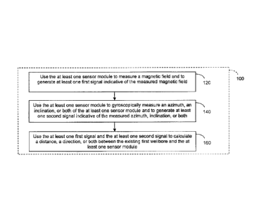
[00531 Figure
5A is a flow diagram of an exarnple method 100 to determine a
distance, a direction, or both between an existing first wellbore 10 and at
least one sensor
module 20 of a drill string 30 within a second wellbore 40 being drilled in
accordance with
certain embodiments described herein. In an operational block 120, the method
100
comprises using the at least one sensor module 20 to measure a magnetic field
and to
generate at least one first signal indicative of the measured magnetic field.
In an operational
block 140, the method 100 further comprises using the at least one sensor
module 20 to
gyroscopically measure an azimuth, an inclination, or both of the at least one
sensor module
20 and to generate at least one second signal indicative of the measured
azimuth, inclination,
or both. In an operational block 160, the method 100 further comprises using
the at least one
first signal and the at least one second signal to calculate a distance
between the existing first
wellbore 10 and the at least one sensor module 20, a direction between the
existing first
wellbore 10 and the at least one sensor module 20, or both a distance and a
direction between
the existing first wellbore 10 and the at least one sensor module 20. In
certain embodiments,
the method 100 further comprises using the calculated distance, the calculated
direction, or
both to control the drill string 30 (e.g., a rotary steerable drill string).
For example, at least
one control signal can be generated (e.g., automatically) in response to the
calculated
distance, the calculated direction, or both, and the at least one control
signal can be
transmitted to a steering mechanism of the drill string 30.
-16-
CA 02854746 2014-06-18
[0054] Figure 5B is a flow diagram of an example method 200 for
controlling a
drill string 30 spaced from an existing first wellbore 10, the drill string 30
drilling a second
wellbore 40, in accordance with certain embodiments described herein. In an
operational
block 210, the method 200 comprises receiving at least one first signal
indicative of a
magnetic field measured by at least a first sensor module 22 of the drill
string 30. The first
sensor module 22 comprises at least one magnetometer. In an operational block
220, the
method 200 further comprises receiving at least one second signal indicative
of an azimuth,
an inclination, or both measured by at least a second sensor module 24 of the
drill string 30.
The second sensor module 24 comprises at least one gyroscopic sensor. In an
operational
block 230, the method 200 further comprises calculating a distance between the
existing first
wellbore 10 and the first sensor module 22, a direction between the existing
first wellbore 10
and the first sensor module 22, or both a distance and a direction between the
existing first
wellbore 10 and the first sensor module 22. In an operational block 240, the
method 200
further comprises generating, in response to at least one of the calculated
distance and the
calculated direction, at least one control signal to be transmitted to a
steering mechanism of
the drill string 30. The method 200 can be performed by a computer system
(e.g., a
microprocessor) in operational communication with the drill string 30 (e,g.,
with at least the
first sensor module 22, at least the second sensor module 24, and the steering
mechanism of
the drill string 30).
[0055] In certain embodiments, systems and methods can be used to
advantageously address the problems or limitations of magnetic ranging systems
and
methods by using at least one sensor module comprising at least one gyroscope
("gyro") to
provide information (e.g., information regarding the azimuth) to supplement
information
provided by the magnetic ranging (e.g., information provided by at least one
sensor module
comprising at least one magnetometer). Certain such embodiments combine the
use of at
least one gyro with at least one of the magnetic ranging systems and methods
described
above to advantageously negate some of the problems described above.
[0056] In certain embodiments, the gyro-assisted magnetic ranging
systems and
methods described herein may allow accurate relative and absolute spatial
positions to be
acquired from the ranging data (e.g., providing definitive results while
avoiding complex and
imprecise calculations based on noisy magnetic measurements alone to remove
Earth's field
-17-
CA 02854746 2014-06-18
effects). In certain embodiments, comparing the gyro-derived information
regarding azimuth
and inclination to the magnetometer-derived information can be used to
identify erroneous
contributions to the magnetometer measurements (e.g., due to going out of
calibration,
magnetic contributions from ferrous formations containing magnetite or
basaltic layers or
from geothermal wells in volcanic formations). In addition, when using an
axial
magnetometer to provide information about the approach of an existing
wellbore, comparing
the gyro-derived information to the magnetometer-derived information can be
used to
optimize the magnetic ranging process by reducing (e.g., avoiding, minimizing)
the effects of
axial magnetization from the drill string itself along the tool axis, thereby
allowing for
ranging while drilling.
[0057] In certain embodiments, the gyro-assisted magnetic ranging
systems and
methods described herein may provide gyro-derived information can be used to
provide a
definitive survey of the wellbore 40 immediately after tripping the drill
string 30 out of the
wellbore 40. In contrast, using magnetic ranging- or MWD-derived information
alone can
take two to three days of analysis to generate a full survey which includes
both azimuth and
inclination. In certain embodiments, back calculations and iterative
techniques may be used
to estimate the wellbore position.
[0058] In certain embodiments, the gyro-assisted magnetic ranging
systems and
methods described herein can be used to automate rotary steerable drilling
(e.g., by reducing
the role of a human operator in steering the drill string 30 while drilling
the second wellbore
40 as compared to conventional magnetic ranging techniques). The at least one
sensor
module 20 can comprise a MWD sensor pack of a rotary steerable drilling tool.
For example,
the at least one sensor module 20 can comprise at least one gyro module and at
least one
magnetometer module, or a first sensor module 22 comprising at least one gyro
and a second
sensor module 24 comprising at least one magnetometer. The at least one sensor
module 20
can be positioned in a wide range of locations along the drill string 30
(e.g., below the
steering mechanism, in the steering mechanism, or above the steering
mechanism) and can be
used to provide the measurements to be used as part of the gyro-assisted
magnetic ranging.
For example, the at least one sensor module 20 can be above the steering
mechanism by a
distance between 40 meters and 70 meters. For another example, the at least
one sensor
module 20 positioned below the steering mechanism in proximity to the drill
bit (e.g.,
-18-
CA 02854746 2014-06-18
directly behind the drill bit, above the drill bit by a distance between 10
meters and 15
meters) in the rotary steerable tool can be used as part of the gyro-assisted
magnetic ranging.
In certain embodiments, using at least two magnetic sensor modules (e.g., one
sensor module
positioned above the steering mechanism and another sensor module positioned
below the
steering mechanism) can provide information on the angle of approach of the
drill string 30
to the existing first wellbore 10 (see, e.g., U.S. Pat. Nos. 8,095,317 and
8,185,312). In
certain embodiments, using at least two magnetic sensor modules can provide
information to
be used to reduce the effect of bias created by magnetic interference from BHA
components.
For example, measurements taken with a first magnetic sensor module near a
ferromagnetic
BHA component (e.g., sufficiently near to provide measurements affected by a
magnetic
field of the BHA component) and a second magnetic sensor module spaced away
from the
ferromagnetic BHA component (e.g., sufficiently away to provide measurements
not affected
by a magnetic field of the BHA component) can be subtracted from one another
to provide
information regarding residual biases due to the magnetic field of the BHA
component.
[0059] Certain embodiments described herein are configured to drill a
predetermined well path while locating a target well with a reduced role of a
human operator
(e.g., automatically). The predetermined well path can be selected to keep a
predetermined
distance between the target well and the well being drilled, to intercept the
target well at a
predetermined position (e.g., true vertical depth) or formation, or to find
and stay within a
formation. In certain embodiments, the gyro-assisted magnetic ranging systems
and methods
described herein can be used in conjunction with active magnetic ranging to
automate rotary
steerable drilling. In certain other embodiments, the gyro-assisted magnetic
ranging systems
and methods described herein can be used in conjunction with passive ranging
(e.g.,
detection of remnant magnetization in the target well casing, for target well
interception or
target well avoidance) to automate rotary steerable drilling.
[0060] In certain embodiments, the gyro-assisted magnetic ranging
systems and
methods described herein can provide more accurate detection or warnings of
approaching a
target well. For example, while magnetic ranging alone may give a warning of
the second
wellbore 40 approaching the first wellbore 10, the gyro measurements can be
used to
generate values of the azimuth and inclination of the second wellbore 40.
These values can
be compared to those of previous surveys of the first wellbore 10 to determine
a proximity
-19-
CA 02854746 2014-06-18
between the first wellbore 10 and the second wellbore 40. In addition, the
gyro
measurements can be used to estimate the magnetic fields expected to be
detected at the
particular azimuth and inclination determined by the gyro sensor module 24.
Deviations or
distortions between the expected magnetic fields and the measured magnetic
fields can be
indicative of the existence of the first wellbore 10 in proximity to the
second wellbore 40.
For example, deviations of the measured magnetic field magnitude and dip angle
(e.g.,
calculated using equations as disclosed more fully below) and the expected
values of these
same quantities (e.g., from the Earth's magnetic field) can be used to
indicate the existence of
the first wellbore 10 in proximity to the second wellbore 40.
[0061] In certain embodiments, the gyro-assisted magnetic ranging
systems and
methods described herein include a gyro (e.g., a gyro having small errors at
high angles of
inclination), in conjunction with magnetic survey instruments. Certain such
embodiments
may overcome the problem of poorly derived azimuths and Earth's magnetic field
removal in
conventional ranging systems. Certain such embodiments can advantageously
provide more
accurate ranging data for the relative position of the second wellbore 40. In
addition, the
gyro data may give a more reliable and accurate absolute wellbore position.
[0062] In certain embodiments, by using a gyro, the gyro-assisted
magnetic
ranging systems and methods described herein may advantageously reduce the
number of
ranging survey measurements to be taken as compared to magnetic ranging
systems and
methods that do not utilize gyro measurements. By sending inclination and
azimuth
measurements to the surface to calculate steering commands, the gyro-assisted
magnetic
ranging systems and methods described herein may reduce the number of high
resolution
magnetometer measurements (e.g., 100 nanotesla) transmitted to the surface for
the ranging
calculations, as compared to conventional MWD-based ranging systems and
methods.
[0063] For example, the number of magnetic ranging survey measurements
taken
can be reduced (e.g., to one per casing joint), thereby saving time and
allowing faster well
completion. For example, the duration of the magnetic ranging process at each
station (e.g.,
taking six high-resolution magnetometer and accelerometer measurements at each
station,
with the stations spaced from one another by about 11-13 meters) can be 8
minutes
(assuming mud pulse telemetry), resulting in a total ranging time using
magnetic ranging
alone of 96 minutes for each 100 meters drilled. By using gyro measurements in
-20-
CA 02854746 2014-06-18
combination with magnetic ranging measurements to provide information
regarding azimuth
and inclination at intervening stations (e.g., two relatively low-resolution
measurements of 2
minutes duration each), the number of magnetic survey measurements can be
reduced (e.g.,
to one per 100 meters). Thus, the total time for which drilling is stopped for
the gyro-
assisted magnetic ranging technique then can be about 24 minutes per 100
meters drilled,
which is about one hour less for every 100 meters drilled using magnetic
ranging alone.
Besides saving time during drilling, by reducing the period of time during
which the drill
string 30 is stopped for taking measurements (e.g., fewer long-duration
magnetic ranging
measurements being made), certain such embodiments can reduce the probability
of the drill
string 30 getting stuck in the wellbore 40. Note that the benefits of time
saved and reduced
probability of getting stuck for gyro-assisted magnetic ranging as compared to
magnetic
ranging alone using electromagnetic ranging relate largely to the time taken
to transmit data
to the surface, which would be less in configurations in which faster
communication is
possible (e.g., the time per magnetic ranging measurement is significantly
smaller for
electromagnetic telemetry than for mud pulse telemetry).
[0064] To
illustrate this aspect, Figures 6A schematically illustrates the positions
of a number of standard magnetic ranging survey measurements to be taken along
a target
box 50 that is 570 meters long and Figure 6B schematically illustrates the
positions of a
fewer number of gyro-assisted ranging survey measurements to be taken along
the target box
50. As shown in Figure 6A, because of the larger reference errors in magnetic
ranging, many
magnetic ranging survey measurements (at positions denoted by vertical arrows
along the
target box 50) are to be taken along the target box 50 in an attempt to keep
the second
wellbore 40 within the target box 50. In contrast, as shown in Figure 6B,
using gyro-assisted
magnetic ranging, the number of survey measurements to be taken along the
target box 50 (at
positions denoted by vertical arrows along the target box 50) can be fewer
(e.g., by
approximately a factor of 16) than in Figure 6A. For example, if a gyro has a
reference error
of 0,3 degree, then it is possible the second wellbore 40 would leave the
target box 50 after
190 meters, assuming no ranging error. With the inclusion of a gyro, the
influence of the
ranging error can be reduced (e.g., by only performing gyro-assisted ranging
survey
measurements when the uncertainty reaches the edge of the target box 50). For
example,
allowing for a horizontal positional ranging error of about +/-0.25 meter (at
5 meters), the
-21-
CA 02854746 2014-06-18
second wellbore 40 could leave the target box 50 after 143 meters has been
drilled. It may be
expedient to allow for other errors and so a 120 meter ranging interval could
be optimum,
thereby saving time and being less problematic than the standard ranging
survey practice for
surveying every joint (about every 10-13 meters). Certain embodiments
described herein
with the inclusion of a gyro could reduce the ranging survey requirement by
about 90%.
[0065] In addition, by providing azimuth and inclination information,
the gyro
measurements can be used to allow the Earth's magnetic field to be removed
from the
ranging calculations. For example, once the azimuth and inclination of the
downhole portion
are known from the gyro measurements, reference information (e.g., a model; a
database)
regarding the Earth's magnetic field at various azimuths and inclinations can
be accessed,
and the measured azimuth and inclination can be used to determine a
contribution from the
Earth's magnetic field to the measured magnetic field that can be expected at
the measured
azimuth and inclination. This expected contribution to the measured magnetic
field can then
be subtracted from the measured magnetic field to provide a corrected measured
magnetic
field to be used in the ranging calculations, as described more fully below.
[0066] Gyro-assisted magnetic ranging can be used to drill infill wells
that are
positioned between existing well pairs, and to re-drill wells positioned
adjacent to the drilled
second well. Infill wells are when the lateral sections are often about 100
meters apart, and
another well is drilled in between to aid production or injection. Re-drills
are often used
when wells have sanded up, steam jumped, or other causes. When either drilling
infill wells
or re-drilling wells, it can be advantageous to have access to an accurate
absolute position of
the existing wells. If the absolute position is accurate, then the risk of
collision can be
avoided (e.g., reduced) and the recovery from the reservoir can be optimized.
As previously
described, magnetic surveys may be adversely affected by interference from
BHAs, other
wells, magnetic storms, etc. Such interference may create large uncertainties
in the absolute
wellbore position. In certain embodiments described herein, use of a gyro in
ranging systems
and methods does not suffer from such issues and can provide increasingly
accurate absolute
and relative wellbore positions. Also, the less frequent use of the
electromagnet means the
casing in the first wellbore may be less magnetized and therefore less likely
to distort the
electromagnetic field.
-22-
CA 02854746 2014-06-18
Determining the Interference Field Due to Proximity to Another Wellbore
[0067] In
certain embodiments, gyro-assisted magnetic ranging uses a
determination of the interference field due to the proximity of the wellbore
being drilled to
another previously-drilled wellbore. At least one magnetometer module of the
at least one
sensor module 20 can be subject to the Earth's magnetic field plus an
interference field
which, for the purpose of the following analysis, can be assumed to be wholly
the result of
proximity of the at least one magnetometer module to a nearby wellbore (e.g.,
the first
wellbore 10; the target wellbore). For
example, in passive ranging, the remnant
magnetization of at least one casing or casing joint of the target wellbore
can contribute to
the interference field. In another example, in active ranging, a magnetic
field created within
the target wellbore (e.g., using an electromagnet such as a solenoid) can
contribute to the
interference field, in addition to any remnant magnetization.
[0068] The
components of the magnetic field sensed by the at least one
magnetometer module (Hõ, Hyr,[1õ) can be expressed as the sum of the
components of the
Earth's magnetic field (fix, Hy, Hz) and the components of the interference
field (H,i, Hyl,
Hzi) as follows:
Hxr = Hx Hx1
Hp- -7-- Hy + Hyi
Hzr = Hz Hzi
The ranging calculations can be based upon estimates of the interference
field, the
components of which can be determined by subtracting the components of the
Earth's
magnetic field from the components of the magnetic field measured by the at
least one
magnetometer module:
Hxi Hxr Hx
Hyi = Hy, ¨ Hy
Hzi = Hzr Hz
[0069] In
certain embodiments, the components of the Earth's magnetic field to
be subtracted from the components of the measured magnetic field can be
derived using
knowledge of the total Earth's magnetic field (He), the magnetic dip (D), and
the orientation
of the drilling tool as defined by its azimuth (A), inclination (/), and high
side rotation (R),
viz.:
-23-
CA 02854746 2014-06-18
Hx= He(cosD cosA cosl sinR sinD sinl sinR + cosD sinA cosR)
Hy = He(cosD cosA cosI cosR ¨ sinD sinl cosR ¨ cosD sinA sinR)
Hz = He(cosD cosA sinl + sinD cosI)
[0070] Values
of the inclination and high side rotation can be obtained from
accelerometer measurements by the at least one sensor module 20 (e.g., by one
or more
accelerometers), values of the azimuth can be obtained from gyroscopic
measurements by the
at least one sensor module 20 (e.g., by one or more gyros), and values of the
total Earth's
magnetic field and the magnetic dip can be known.
[0071] Note
that the azimuth of the drilling tool is used to define the Earth's
magnetic field effect on the magnetometers. If the azimuth is not well known
(e.g., guessed),
then the results of Hz, Hy, and Hz will be in error. Any results that follow
that are used to
determine ranging data (e.g., distance and direction to the target well), such
as the total
interference field (H,), the magnetic inclination (111i), and the direction of
the interference
vector (Di,), will also be in error. If the azimuth is well known (e.g., from
an accurate gyro
measurement), then the resulting ranging data should also be accurate.
Furthermore, if any
of these values are not well defined, then the computed components of the
Earth's magnetic
field (H,, Hy, Hz) will be in error, and it follows that any ranging
calculations carried out
based on the estimated interference field will also be in error.
[0072] For
ranging, the following values can be calculated using the components
of the estimated interference field (Ht, Hyi, The
total interference field (Hi) can be
expressed as: Hi= (Hxi2 Hyi2 4. H2)112. The magnetic inclination (M,) with
respect to the
longitudinal axis of the tool can be expresses as the angle: M, = ATan[(11,,2
+ H),2)Ir2 I
The direction of the interference vector (Dv) with respect to the projection
of the longitudinal
axis of the tool into the horizontal plane can be expressed as:
Dv= ATan[qGx2+Gy2+Gz2)1/2*(fixi*Gy_ -0*
Gx))/(Hz,(Gx2+Gy2)+Hzi*Gz*Gz+ Hy,* Gy* Gz)]
where Gx, Gy, and Gz are the three orthogonal components of the gravitational
vector
pointing towards the Earth's center.
[0073] Other
effects on the reliability of the interference vector include, but are
not limited to, BHA magnetic interference, adjacent wells, magnetic storms,
formation
effects (e.g., high Fe content, etc.) and noise in the electromagnet system.
Some of these
effects can be negated (see, e.g., "Location Determination Using Vector
Measurements," G.
McElhinney, EP Pat. No. 0682269, 12.5.95; "Electromagnetic Array for
Subterranean
-24-
CA 02854746 2014-06-18
Magnetic Ranging Operations," G. McElhinney, R. Moore. US Pat. Appl. Publ. No.
2012/0139530, 7 June 2012. An estimation of these effects, after corrections
have been
applied, may be a ranging distance error of the order of 10 to 50 centimeters
at 5 meters
displacement.
[0074] It can be advantageous to correct as many detrimental effects as
possible
to increase the accuracy of the ranging data. For example, using methods such
as Earth's
field monitoring at or near the rig site, multi-station analysis to remove BHA
interference,
and measuring the BHA interference, pre-run, can be used to supplement the
gyro-assisted
magnetic ranging systems and methods described herein. Alternative methods,
including but
not limited to interpolated in-field referencing (IIFR) which takes into
account diurnal
variations in the magnetic field and uses interpolation between measurements
from reference
stations located some distance apart to determine field variations at the
drill site, may also be
employed.
[0075] For BHA interference measurements, an analysis of the
electromagnetic
vectors can indicate the presence of BHA interference and can be used to help
remove its
detrimental effect. For example, Figure 7 schematically illustrates a
comparison between
balanced electromagnetic vectors and unbalanced electromagnetic vectors due to
BHA
interference (note that Figure 7 omits the contribution from the Earth's field
for clarity). In
certain embodiments, the BHA interference contribution can be considered to be
a constant,
and it can be subtracted from the measured magnetic field to derive the
magnetic field due to
the electromagnet 60 and the Earth's field. If there is a BHA interference
vector present,
then an imbalance in the +/- electromagnetic vector will be measured, as shown
in Figure 7.
This imbalance can be solved for by removing the BHA interference vector
(e.g., to create a
balanced +/- electromagnetic vector once the contribution from the Earth's
field has been
removed). Various mathematical processes (see, e.g., "Method for Correcting
Directional
Surveys," G. McElhinney, EP Pat. No. 0793000, May 14, 1996) may be employed to
remove
the BHA interference vector. Once the magnetic fields (e.g., electromagnetic
vectors) due
solely to the electromagnet 60 are determined at a position of the at least
one sensor 20, these
values can be used as described herein to determine the position of the at
least one sensor
module 20 within the second wellbore 40 relative to the electromagnet 60 in
the first
-25-
CA 02854746 2014-06-18
wellbore 10. This determined position can then be used to steer the drill
string 30 in the
second wellbore 40 to a predetermined position relative to the first wellbore
10.
Rotary steerable drilling in conjunction with gyro-assisted magnetic ranging
surveys
[0076] While
the discussion below addresses the drilling of a second wellbore 40
alongside (e.g., parallel) to an existing first wellbore 10, the systems and
methods described
are equally applicable for the drilling of a second wellbore 40 configured to
intercept a first
wellbore 10 (e.g., in the event of a blowout). Similar guidance strategies may
be adopted for
the automation of such a process. For example, gyro-assisted magnetic ranging
can be used
for the terminal stages of the interception process to reduce the role of a
human operator in
steering the second wellbore to intersect the first wellbore.
[0077] In
certain embodiments, a drilling tool 30 (e.g., a drill string) is controlled
(e.g., steered) in response to signals derived from gyro-assisted magnetic
ranging survey
measurements to follow a desired path (e.g., trajectory). For example, the
drilling tool 30 can
be steered to drill a second wellbore 40 that follows a course alongside and
parallel to an
existing first wellbore 10. The desired path of the second wellbore 40 can be
controlled to
remain within at least one target box 50 that follows the existing first
wellbore path at a pre-
defined distance (e.g., a fixed distance above, a fixed distance below, a
fixed distance left, a
fixed distance right) from the first wellbore path. Steering signals (e.g.,
commands) can be
generated to cause the drilling tool 30 to form the second wellbore 40 to
follow, and to
attempt to intercept, a sequence of target boxes 50 defined at intervals along
the first
wellbore path. In certain such embodiments (e.g., where bending is applied to
a flexible
shaft of the rotary steerable tool in proportion to the angle between the tool
axis and the
target line of sight), the steering signal magnitudes are proportional to the
angular differences
(e.g., in inclination and azimuth) between the next target line of sight and
the orientation of
the drilling tool 30. Given
knowledge of the coordinates of the drilling tool 30 and the
location of the first wellbore 10 in the chosen reference frame, the target
line of sight relative
to the drilling tool 30 can be updated for each well section.
[0078] In
certain embodiments, the second wellbore path may be a predetermined
distance (e.g., 3 ¨ 5 meters separation) from the first wellbore path that is
sufficiently small
such that magnetic ranging is conducted. In certain such embodiments (e.g.,
when a new
well is to be drilled in close proximity to an existing well, such as in the
case of SAGD
-26-
CA 02854746 2014-06-18
applications), magnetic ranging is viable and gyro-assisted magnetic ranging
can be used to
provide information used to achieve the desired second wellbore path (e.g.,
trajectory). For
example, standard survey methods may be used to guide the second wellbore 40
to within
range of the first wellbore 10 such that magnetic ranging can be used.
Thereafter, a guidance
strategy based on a local reference frame defined by the relative separation
and orientation of
the second wellbore 40 with respect to the first wellbore 10 may be adopted.
In certain such
embodiments, the drilling tool location with respect to the next target boxes
can be updated
periodically as new ranging measurements becomes available.
[0079] In certain embodiments, a closed-loop drilling process is used
to control
(e.g., steer) a drilling tool 30 (e.g., a rotary steerable drill string). For
example, a BHA
within the second wellbore 40 can comprise a drill bit at an end of the rotary
steerable drill
string, a first sensor module 22, and a second sensor module 24 spaced from
the first sensor
module 22 along the rotary steerable drill string in a direction away from the
drill bit. The
first sensor module 22 can comprise a plurality of rotary steerable sensors
(e.g., a plurality of
magnetometers, accelerometers, and/or gyros). The second sensor module 24 can
comprise a
magnetic MWD sensor pack and a gyroscopic GWD sensor pack.
100801 Figure 8A schematically illustrates an example configuration of
a drilling
tool 30 configured to drill a second wellbore 40 (e.g., drilling well) along a
desired path
parallel to and in close proximity to a first wellbore 10 (e.g., target well).
The drilling tool 30
comprises a steering mechanism configured to controllably adjust the tool path
direction
(e.g., direction in which the second wellbore 40 is being drilled) in response
to at least one
steering signal (e.g., command) from a computer system (e.g., a computer
processor mounted
on the drilling tool 30 or outside the second wellbore 40). The drilling tool
30 further
comprises at least a first sensor pack 22 positioned below the steering
mechanism (e.g., in
proximity to a drill bit of the drilling tool) and at least a second sensor
pack 24 positioned
above the steering mechanism (e.g., such that the steering mechanism is
between the first
sensor pack 22 and the second sensor pack 24).
[0081] Figure 8B is a flow diagram of an example method 400 of drilling
a
second wellbore 40 (e.g., drilling well) along a desired path parallel to a
first wellbore 10
(e.g., target well). The second wellbore 40 can be in close proximity to the
first wellbore 10
(e.g., within 3-5 meters). The method 400 can be performed by the computer
system of the
-27-
CA 02854746 2017-01-03
=,=-=
drilling tool 30. In an operational block 410, a target position can be
defined along a desired
path of the second wellbore 40. The target position can be spaced a distance
(d) from the
current position of the drilling tool 30. In an operational block 420,
magnetic ranging
measurements relative to the first wellbore 10 and gyroscopic measurements of
an azimuth,
an inclination, or both of the drilling tool 30 are made, and these
measurements are used to
determine a distance () between the current position of the drilling tool 30
and the first
wellbore 10. For example, the distance () can be measured or derived using
magnetic
ranging measurements using the first sensor module 22, the second sensor
module 24, or both
the first sensor module 22 and the second sensor module 24 with these magnetic
ranging
measurements corrected using the gyroscopic measurements as described herein.
Magnetic
ranging measurements can be used to provide information regarding the distance
of the
drilling tool 30 (e.g., an end portion of the drill string, the drill bit, the
first sensor module 22)
from the first wellbore 10 and the direction of the second wellbore path with
respect to the
first wellbore path.
[0082]
In an operational block 430, a distance (As = ¨ s) between the first
wellbore path and the desired path of the second wellbore 40 can be
calculated. In an
operational block 440, a target sightline angle (fl = arctan{1) with respect
to the desired
path of the second wellbore 40 can be calculated. In an operational block 450,
a tool path
direction (a) with respect to the first wellbore path can be measured (e.g.,
using the first
sensor module 22, the second sensor module 24, or both the first sensor module
22 and the
second sensor module 24). In an operational block 460, a steering angle (y = a
¨ /3) can be
calculated. In an operational block 470, a steering signal (e.g., command) can
be transmitted
to the steering mechanism (e.g., a shaft bending mechanism, an example of
which is
described in U.S. Pat. No. 8,579,044) to control the steering mechanism to
adjust the tool
path direction by the steering angle. In certain embodiments, the steering
signal has a
magnitude proportional to the steering angle. In an operational block 480, a
new target
position along the desired path of the second wellbore 40 is defined, the new
target position a
distance (d) from the current position of the drilling tool 30 (e.g., since
the drill string has
moved by virtue of drilling the second wellbore 40). The method 400 can
further comprise
iterating the operational blocks 420-480 (denoted in Figure 8B by the arrow
490).
-28-
CA 02854746 2014-06-18
[0083] Figure 9 schematically illustrates an example measurement of the
tool path
direction (a) with respect to the first wellbore path using the first sensor
module 22 and the
second sensor module 24. Using information regarding the distance (h) between
the first
sensor module 22 and the second sensor module 24, the measured distance (1)
between the
current position of the first sensor module 22 and the first wellbore 10, and
the measured
distance ( 2) between the current position of the second sensor module 24 and
the first
wellbore 10, the tool path direction can be provided by the relation: a =
arcsinC2-h 1). A
similar calculation can be performed for a "dogleg" section of the drilling
tool 30, given an
estimate of the bend of the drilling tool 30 between the first sensor module
22 and the second
sensor module 24.
[00841 Figure 10 schematically illustrates an example progression of
the drilling
tool 30 using multiple iterations of the example method 400 of Figure 88. With
each
successive target point along the desired path of the second wellbore 40, the
achieved path of
the second wellbore 40 gets closer to the desired path.
[0085] In certain embodiments, the second wellbore path may be a
predetermined
distance (e.g., 30 ¨ 50 meters separation) from the first wellbore path that
is sufficiently large
such that magnetic ranging is not conducted. In certain such embodiments
(e.g., when so-
called in-fill drilling is carried out), the steering signals can be based on
information
regarding the absolute spatial position of the first wellbore 10 and the
second wellbore 40.
The first wellbore path may be provided by surveys conducted earlier while the
second
wellbore path may be determined using an on-board survey system (e.g., a
magnetic survey
system, a gyro survey system, or a combination of a magnetic and a gyro survey
system) of
the drilling tool 30 within the second wellbore 40. For example, a gyro survey
system can be
used to provide information regarding the second wellbore path, and
information from
magnetic sensors can be used to supplement the gyro-derived information (e.g.,
for quality
assurance of changes in the gyro-derived information). In certain embodiments,
the distance
between the second wellbore 40 and the first wellbore path is too large for
magnetic ranging
to be used, while in certain other embodiments, magnetic ranging measurements
are used to
supplement the absolute spatial position measurements.
[0086] For example, the inclination of the drilling tool 30 may be
determined
using measurements of the gravitational vector obtained from a plurality
(e.g., a triad) of
-29-
CA 02854746 2017-01-03
=
accelerometers of the drilling tool 30, the accelerometers mounted to have
their sensitive
axes nominally coincident with the xyz axes of the drilling tool 30. The tool
azimuth may be
determined using a combination of the gravitational measurements and
measurements of the
Earth's rotation vector obtained from a plurality (e.g., a triad) of rate
gyroscopes, also
mounted with their sensitive axes nominally coincident with the xyz axes of
the drilling tool
30. Steering signals (e.g., commands) can then be generated (e.g., by the
computer system)
and transmitted to the steering mechanism, with the steering signals being
functions of the
inclination and azimuth differences between the target direction and tool
orientation so as to
cause the drilling tool 30 to rotate to point in the direction of the next
target location as
drilling proceeds.
[0087] To define accurately the target vector in the chosen reference
frame,
accurate information regarding the drilling tool position is desirable. Such
accurate drilling
tool position information can be generated by combining the measured
inclination and
azimuth with the distance moved along the path of the second wellbore 40
(e.g., the
measured depth of the second wellbore 40). For example, such information can
be generated
using a minimum curvature process. Other methods for determining the depth of
the second
wellbore 40 can be based entirely on downhole measurements (rather than
surface
measurements), examples of which are described in U.S. Patent Nos. 6,957,580
and
8,065,085.
[0088] In general, the path of the first wellbore 10 will not be
straight. Therefore,
the absolute location of the target box 50 will move as the second wellbore 40
is drilled in
order to maintain a fixed relative position with respect to the first wellbore
10. A strategy is
therefore desirable for moving from one target box location to the next as the
second
wellbore 40 is drilled. One possible strategy is to select a new target box 50
as the second
wellbore 40 approaches the previous target box 50. The frequency of the target
boxes along
the desired wellbore path, along with the dog-leg capability of the rotary
steerable tool, can
be selected to ensure that the distance of the second wellbore 40 from the
first wellbore 10 is
maintained to within acceptable limits.
Examples of Gyro-Assisted Magnetic Ranging
[0089] In certain embodiments, the techniques described herein can utilize
combinations of static gyro surveying, static magnetic surveying, magnetic
ranging
-30-
CA 02854746 2014-06-18
surveying, and dynamic magnetic analysis during drilling at various phases of
the drilling
process. In the example case of steam assisted gravity drainage (SAGD)
drilling, the ends
12, 42 at or near the Earth's surface of the first wellbore 10 (e.g., the
previously-drilled target
wellbore) and the second wellbore 40 (e.g., the wellbore being drilled),
respectively, are
spaced substantially apart from one another, as schematically illustrated in
Figure 11. Figure
11 includes a plan view of the first and second wellbores 10, 40 from above
the Earth's
surface in a direction perpendicular to the Earth's surface, and a section
view in a direction
parallel to the Earth's surface. In certain such configurations, there is
little or no magnetic
interference from the casings of the first wellbore 10 to be detected by the
at least one sensor
module 20 of the drilling tool 30 in the second wellbore 40 being drilled. In
certain such
configurations, standard gyro surveying can be performed during the initial
phase of the
drilling process to determine the position of the second wellbore 40, while
monitoring data
generated by the at least one sensor module 20 (e.g., by at least one
longitudinal axis
magnetometer) to detect the approach to the first wellbore 10 (e.g., the
approach to the
casings of the first wellbore 10 and/or the electromagnet 60 within the first
wellbore 10).
[0090] In
certain embodiments, the electromagnet 60 can be positioned at or near
the planned interception point 70 of the two wellbores (e.g., at the point at
which the second
wellbore 40 is first at the desired distance for "twinning" the first wellbore
10). In certain
embodiments, the electromagnet 60 can be switched on (e.g., for a single shot
of about 40
seconds) and positioned at a distance (e.g., between about 10 meters and about
60 meters;
about 40 meters) before the interception point 70 and the measurements by the
axial
magnetometer of the at least one sensor module 20 can be monitored for the
switch point, as
described below. Due to the possibility of any accumulative or gross errors
having been part
of each well survey, the spatial positions may be incorrect. To compensate for
the possibility
of any such spatial positional errors, it can be advantageous to start the
magnetic ranging
process sufficiently ahead of the perceived interception point 70. In certain
embodiments,
the electromagnet 60 is positioned at a distance before the interception point
70 that
advantageously allows safe drilling of the second wellbore 40 to within a
predetermined
distance from the first wellbore 10 at which magnetic ranging can be initiated
and then used
(e.g., to follow a second wellbore path that is parallel to the first wellbore
path).
-31-
CA 02854746 2017-01-03
,
[0091] As the second wellbore 40 approaches the electromagnet 60 in the first
wellbore 10, the measured magnetic field 62 from the electromagnet 60 will
increase and the
flux angle will change. The measurements of the magnetic field can be used to
derive (e.g.,
converted into) information regarding the position of the at least one sensor
module 20
relative to the electromagnet 60.
In certain embodiments, this derivation uses a
predetermined mapping of the parameters of the magnetic field generated by the
electromagnet 60 (e.g., the three orthogonal components of the magnetic field;
the axial field
component and the cross axial field component; the magnitude and the flux
angle) as a
function of position relative to the electromagnet 60. This mapping can be
stored in memory
of the computer system controlling the drilling of the second wellbore 40
(e.g., can be stored
in the form of a model, simulation, database, lookup table, or other format).
For example, a
finite element calculation package (e.g., David Meeker, "Finite Element Method
Magnetics,"
Version 4.2, User's Manual, 2010) can be used to derive the mapping of
expected magnetic
parameter values for two-dimensional planar or axisymmetric configurations.
The mapping
can have sufficient resolution to provide the desired level of precision in
position as a
function of measured magnetic field 62. In certain embodiments, interpolation
among the
values in the mapping can be used to find the appropriate position
corresponding to the
measured magnetic field parameter values.
[0092]
In certain embodiments, as described more fully below, the measured axial
field component (Mz) of the magnetic field along the longitudinal axis of the
second wellbore
40 may advantageously be compared to the predetermined mapping of the magnetic
field so
as to be used to determine the position of the at least one sensor module 20
relative to the
electromagnet 60. The measured axial field component can be measured in this
manner
during drilling of the second wellbore 40 (e.g., while the at least one sensor
module 20 is
rotating about the longitudinal axis) or during periods when drilling using
the drill string 30
has stopped (e.g., while the at least one sensor module 20 is not rotating
about the
longitudinal axis). Use of the measured axial field component is possible
during drilling
since the values of the axial field component measured by the rotating sensor
module 20
remain unchanged during the drilling-related rotation of the at least one
sensor module 20
about its longitudinal axis. In other words, the measured axial field
component is not
-32-
CA 02854746 2014-06-18
dependent on the rotation of the at least one sensor module 20 about its
longitudinal axis. In
addition, while the measured cross axial field components (Mx and My) do vary
while the at
least one sensor module 20 rotates about its longitudinal axis, the measured
flux angle
relative to the longitudinal axis of the at least one sensor module 20 (e.g.,
atan[(Mx2+My2) I /2/m,]) does not; it is dependent on the spatial position of
the at least one
sensor module 20 relative to the electromagnet 60.
[0093] In
certain embodiments, during periods in which drilling using the drill
string 30 has stopped, the measured cross axial field components (Mx and My)
may be used
in addition to the measured axial field component (M), as described more fully
below. In
certain such embodiments, the measured flux angle relative to the longitudinal
axis of the at
least one sensor module 20 can be calculated from the axial and cross axial
field components
(e.g., atan[(Mx2+My2)1/2/mz])s
without using accelerometer measurements (e.g., from the at
least one sensor module 20). In
certain other embodiments, such accelerometer
measurements may be used in conjunction with the measured axial and cross
axial field
components (e.g., to determine the orientation relative to the Earth's
gravity). In certain
embodiments, the spatial position of the at least one sensor module 20 in the
second wellbore
40 relative to the electromagnet 60 in the first wellbore 10 can be determined
by deriving the
flux angle using the orientation of the at least one sensor module 20 (e.g.,
using
accelerometer data), the angle of interception of the longitudinal axis of the
at least one
sensor module 20, the cross axial tool face interception (e.g., using
accelerometer data), and
the orientation of the electromagnet 60 (e.g., from historical data). Other
methods may also
be used to derive the target well flux angle interception. In certain
embodiments, the relative
position of the second wellbore 40 to the first wellbore 10 can be derived
(e.g., while steering
the drilling tool 30 with a rotary steerable assembly or a three-dimensional
steerable device).
[0094] Figure
12A schematically illustrate the magnetic field 62 generated by an
electromagnet 60 in accordance with certain embodiments described herein. The
left side of
Figure 12A schematically illustrates a side view of the first wellbore 10, the
electromagnet
60, and the magnetic field 62, showing that the magnetic field 62 is cross
axial to the first
wellbore 10 (e.g., with an axial field component parallel to the longitudinal
axis of zero) at
various positions spaced from the first wellbore 10 and along the first
wellbore 10 (e.g., as
denoted by the dashed lines). As described more fully below, these positions
can be
-33-
CA 02854746 2014-06-18
considered to be "switch points." The right side of Figure 12A schematically
illustrates a
view of the first wellbore 10, the electromagnet 60, and the magnetic field
62, which also
shows that the cross axial component of the magnetic field 62 at these switch
points are
directed either towards or away from the first wellbore 10. While an increase
or decrease of
the current running through the electromagnet 60 results in a respective
increase or decrease
of the magnetic field intensity, the flux line shape of the magnetic field
remains unchanged
by such changes of the current. Therefore, a set of predetermined values of
the parameters
that characterize the magnetic field generated by the electromagnet can be
obtained (e.g., by
measuring these values for at least one current running through the
electromagnet 60 prior to
the electromagnet 60 being inserted into the first wellbore 10). The set of
predetermined
values of the parameters that characterize the magnetic field can then be used
in comparison
with values measured while the electromagnet 60 is within the first wellbore
10 (once the
predetermined values are scaled to the same current running through the
electromagnet 60
during the measurements using the at least one sensor module 20 in the second
wellbore 40)
in accordance with certain embodiments described herein.
[0095] The
top portion of Figure 12B schematically .illustrates an SAGD
configuration in which a portion of the second wellbore 40 (e.g., the drilling
well) is in
proximity to and parallel to a portion of the first wellbore 10 (e.g., the
target well) containing
the electromagnet 60. The bottom portion of Figure 12B schematically
illustrates measured
values of the axial field component (in arbitrary units) measured by a
longitudinal axis
magnetometer at various positions along the second wellbore 40. As the
longitudinal axis
magnetometer of the at least one sensor module 20 moves along the second
wellbore 40,
approaching the electromagnet 60 in the first wellbore 10, and traversing past
the
electromagnet 60 (e.g., moving from left to right in Figure 12B), the flux
angle detected by
the longitudinal axis magnetometer will switch direction and the axial field
component
detected by the longitudinal axis magnetometer will vary. A first switch point
(denoted in
Figure 12B by a first star) can be defined as the position of the longitudinal
axis
magnetometer where the component of the magnetic flux parallel to the second
wellbore 40
(e.g., the axial field component) switches from pointing in one direction to
pointing in the
opposite direction (e.g., changes sign from having a negative value to having
a positive
value). A second switch point (denoted in Figure 12B by a second star) can be
defined as the
-34-
CA 02854746 2014-06-18
position of the longitudinal axis magnetometer where the component of the
magnetic flux
parallel to the second wellbore 40 (e.g., the axial field component) switches
back to pointing
in the direction it pointed prior to reaching the first switch point (e.g.,
switches sign from
having a positive value to having a negative value). At each switch point, the
intensity of
the detected magnetic field 62 can be used to derive the total distance and
cross axial distance
to the pole of the electromagnet 60. For example, by comparing the measured
magnetic field
parameters to a set of predetermined values of these parameters that
characterize the
magnetic field generated by the electromagnet 60 (e.g., in a table, database,
model,
simulation, or other form), certain embodiments described herein can derive
(e.g., convert;
translate) the measurements of the magnetic field to values of the total
distance and cross
axial distance from the at least one sensor module 20 to the pole of the
electromagnet 60.
[0096] At the first switch point, a magnetic ranging survey can be
taken to
determine the relative position of the second wellbore 40 with respect to the
first wellbore 10.
In certain embodiments, a second magnetic ranging survey may be taken at the
second switch
point if deemed necessary. For example, if the first magnetic ranging survey
is deemed to
have a sufficiently reduced quality (e.g., noisy; large jumps in values
between adjacent
points), then the second magnetic ranging survey may be taken. One or both of
the switch
points can be optimal positions at which to take a magnetic ranging survey as
the cross axial
component of the magnetic flux is large at the switch points, which can help
define more
accurately the relative position of the second wellbore 40 to the first
wellbore 10.
[0097] Upon determining the relative position of the second wellbore 40
to the
first wellbore 10, action can be taken to steer the second wellbore 40 within
the target box
50. Once the relative position of the second wellbore 40 is determined with
respect to the
target box 50, the electromagnet 60 can be moved to a new position further
down the first
wellbore 10 (e.g., 96 meters further down the first wellbore 10) and gyro
survey
measurements can be resumed at each survey station (e.g., at positions spaced
from one
another by 11-13 meters). As the second wellbore 40 again approaches the
electromagnet 60,
the above-described procedure can be repeated.
[0098] The magnetic field 62 from the first wellbore 10 (e.g., the
electromagnet
60) should be detectable many tens of meters before the second wellbore 40 is
parallel to the
first wellbore 10. Although optimal positions for the magnetic ranging survey
has been
-35-
CA 02854746 2014-06-18
described above at the first and second switch points, it is not essential
that a magnetic
ranging survey is taken at one or both of these positions. In certain
embodiments, a magnetic
ranging survey can be carried out at any position along the second wellbore 40
where the
magnetic field 62 from the first wellbore 10 is detectable.
[0099] In certain embodiments, the procedure described herein can be
used for
horizontal to vertical interceptions, or for high angle interceptions (e.g.,
for Coal 13.&1
Methane drilling, synthetic gas drilling, and many other applications). For
example, as
schematically illustrated by the top left portion and the right portion of
Figure 12C, a second
wellbore 40 can extend in a direction that is not generally parallel to the
first wellbore 10
(e.g., that crosses above or below the first wellbore 10). As shown in the
bottom left portion
of Figure 12C, as the longitudinal axis magnetometer of the at least one
sensor module 20
moves along the second wellbore 40, approaching the electromagnet 60 in the
first wellbore
10, and traversing past the electromagnet 60 (e.g., moving from left to right
in the top left
portion of Figure 12C), the measured axial field component (shown in arbitrary
units in the
bottom left portion of Figure 12C) detected by the longitudinal axis
magnetometer will
switch direction at the point of closest approach of the second wellbore 40 to
the first
wellbore 10 (e.g., the switch pattern in the high angle interceptions occurs
at the point of
closest approach of the second wellbore 40 to the first wellbore 10).
[0100] In certain embodiments, the rate of change of the intensity of
the magnetic
field, the flux angle, and the flux direction may be used to determine the
distances between
the second wellbore 40 and the first wellbore 10 and the relative cross axial
position. For
example, as the pole of the electromagnet 60 is approached, the detected rate
of change
increases, and this information can be used to dynamically monitor the
approach of the
drilling tool 30 to the first wellbore 10.
[0101] Figure 13A schematically illustrates an example configuration
including a
table of example measured values of the various parameters of the magnetic
field 62 from the
electromagnet 60 in accordance with certain embodiments described herein.
These measured
values can be determined by the at least one sensor module 20 (e.g., a
longitudinal axis
magnetometer) within the second wellbore 40, and can be used in conjunction
with a set of
predetermined correlation of these parameters (e.g., magnetic field
intensities; magnetic field
components; flux angle; gradients of these parameters) with the distance
between the at least
-36-
CA 02854746 2014-06-18
one sensor module 20 and the electromagnet 60 to derive the position of the at
least one
sensor module 20 to the electromagnet 60. Besides the magnetic flux lines of
the magnetic
field 62, Figure 13A includes dashed lines which denote lines of constant
total magnetic
intensity. The values shown in Figure 13A are representative of values after
contributions
from the Earth's magnetic field have been removed.
[0102] For example, a longitudinal axis magnetometer within the second
wellbore
40 at a first position relative to the electromagnet 60 in the first wellbore
10 can measure the
values of (measured total magnetic field intensity; the axial magnetic field
component; flux
angle) to be (300 nT; -260 nT; 300 degrees). Using the set of predetermined
correlations of
these parameters with position, these measurements can be used to derive a
relative distance
of 5.5 meters between the long axis magnetometer and the electromagnet 60.
Depending on
the trajectory taken by the second wellbore 40, a second set of measurements
taken by the
long axis magnetometer at a second position can have different values of the
measured
parameters. For example, a second set of measurements taken by the long axis
magnetometer at a second position can measure the values to be (300 nT; +254
nT; 58
degrees). Again using the predetermined correlation of these parameters with
position, the
second position can be determined to be at the location labeled "1" in Figure
13A which is a
relative distance of 6.7 meters from the electromagnet 60. If instead the
second position is at
either the location labeled "2" or "3" in Figure 13A, the measured values will
be different
and so will the relative distance to the electromagnet 60.
[0103] The gradients of one or more of the parameters of the magnetic
field can
be used to determine the relative distance between the at least one sensor
module 20 and the
electromagnet. In certain embodiments, the relative distance at the second
position (e.g., at
one of the locations labeled "1", "2", or "3" as shown in Figure 13A) can be
determined
using only the gradient of the axial magnetic field component from the first
position to the
second position. In certain other embodiments, the gradient of the flux angle
may also be
used.
[0104] In certain embodiments, these gradients are determined using
measurements taken while drilling (e.g., when the at least one sensor module
20 is rotating)
or while the drill string 30 is stationary (e.g., the at least one sensor
module 20 is not
rotating). As described above, if the at least one sensor module 20 is
rotating, the long axis
-37-
CA 02854746 2014-06-18
magnetometer can still provide useful measurements (e.g., to determine the
gradient), while
the variations (e.g., noise) of measurements from the cross axial
magnetometers may not.
The gradient values are dependent on the angle of orientation and the relative
spatial position
between the at least one sensor module 20 and the electromagnet 60. The
derivation of the
relative distance during drilling can be useful in determining whether the
second wellbore 40
is approaching the first wellbore 10, paralleling the first wellbore 10, or
deviating away from
the first wellbore 10.
[0105] However, while the relative distance may be derived from the
magnetic
field measurements, because the magnetic field is radially symmetric around
the
electromagnet 60, additional inforrnation may be used to make a determination
of the angular
position of the at least one sensor module 20 with respect to the
electromagnet 60. For
example, the orientation (e.g., inclination and azimuth) of both the at least
one sensor module
20 and the electromagnet 60 can be known from static and historical surveys,
and using such
information, the spatial position of the second wellbore 40 relative to the
first wellbore 10
can be derived. In certain embodiments, measurements taken while the at least
one sensor
module 20 is not rotating (e.g., stationary) can be used to determine which
cross axial
quadrant the at least one sensor module 20 is in with respect to the
electromagnet 60. Once
this additional information is obtained, the second wellbore 40 can then be
steered correctly
during drilling to its optimum position using only the axial magnetic field
component
measurements, thereby providing the ability to dynamically monitor the
approach of the
second wellbore 40 to the first wellbore 10.
[0106] Figure 13B schematically illustrates an example well paralleling
configuration including a table of example measured values of the various
parameters of the
magnetic field 62 from the electromagnet 60 in accordance with certain
embodiments
described herein. Besides the magnetic flux lines of the magnetic field 62,
the bottom right
portion of Figure 13B is a section view that includes dashed lines which
denote lines of
constant total magnetic intensity. The bottom left portion of Figure 13B shows
a cross-
sectional view of the cross-axial magnetic flux pattern in a plane generally
perpendicular to
the first wellbore 10 and to the second wellbore 40 (denoted by a star). The
values shown in
Figure 13B are representative of values after contributions from the Earth's
magnetic field
have been removed.
-38-
CA 02854746 2014-06-18
[0107] For
example, at a series of positions labeled "A" through "F" in Figure
13B, a longitudinal axis magnetometer within the second wellbore 40 can
measure the
various magnetic field values. The values of the axial magnetic field
component in the table
of Figure 13B can be measured dynamically (e.g., during drilling) while the
values of the
total magnetic field intensity, flux angle, and cross axial magnetic field
components can be
measured statically (e.g., while the drill string 30 is stationary). Using
the set of
predetermined correlations of these parameters with position, these
measurements can be
used to derive the relative distance between the second wellbore 40 and the
first wellbore 10
and the angle of orientation of the second wellbore 40 about the first
wellbore 10. As shown
in Figure 13B, using the set of predetermined correlations of the measured
magnetic field
parameters with position, the relative distance between the second wellbore 40
and the first
wellbore 10 is determined to be substantially constant (e.g., 5.5 ¨ 5.9
meters) along the length
of the second wellbore 40 from position "A" to position "F", and the angle of
orientation of
the second wellbore 40 is also determined to be substantially constant (e.g.,
310 degrees) as
well, indicative of successful paralleling of the second wellbore 40 to the
first wellbore 10.
[0108] Figure
13C schematically illustrates an example horizontal to vertical
interception configuration including a table of example measured values of the
various
parameters of the magnetic field 62 from the electromagnet 60 in accordance
with certain
embodiments described herein. As shown in the section view in the left bottom
portion of
Figure 13C and the side view in the middle bottom portion of Figure 13C, the
second
wellbore 40 extends downward in a generally vertical direction generally
towards the first
wellbore 10 containing the electromagnet 60. At a series of positions labeled
"J" through
"0" in Figure 13C, a longitudinal axis magnetometer within the second wellbore
40 can
measure the various magnetic field values. The values of the axial magnetic
field component
in the table of Figure 13C can be measured dynamically (e.g., during drilling)
while the
values of the total magnetic field intensity, flux angle, and cross axial
magnetic field
components can be measured statically (e.g., while the drill string 30 is
stationary). Using
the set of predetermined correlations of these parameters with position, these
measurements
can be used to derive the relative distance between the second wellbore 40 and
the first
wellbore 10 and the angle of orientation of the second wellbore 40 about the
first wellbore
10.
-39-
CA 02854746 2014-06-18
[0109] As shown in Figure 13C, using the set of predetermined
correlations of the
measured magnetic field parameters with position, the region of the second
wellbore 40 in
closest approach to the first wellbore 10 (e.g., between points labeled "M"
and "N" in Figure
13C) has a relative distance between the second wellbore 40 and the first
wellbore 10
between 7.8 meters and 8.1 meters. At these two positions (e.g., where the
measurements
taken during drilling) indicate the closest approach, additional measurements
can be taken
while the drill string 30 is stopped to measure the cross axial field
components to get further
information regarding the relative position of the second wellbore 40 to the
first wellbore 10.
While Figure 13C shows example values for a second wellbore 40 that passes by
the first
wellbore 10, similar information can be used to steer the second wellbore 40
to intersect the
first wellbore 10 while drilling commences. In certain embodiments in which
previously-
obtained measurements of the magnetic field parameters with position are not
available (e.g,
for certain passive ranging situations), the shape of the magnetic field can
be derived (e.g.,
determined) from symmetry-based assumptions (e.g., symmetry about the
longitudinal axis
of the wellbore casing) and using triangulation to provide a set of
predetermined correlations
of the measured magnetic field parameters with position.
[0110] In certain embodiments, upon completion of drilling the second
wellbore
40, the gyro of the at least one sensor module 20 may be used in continuous
mode, static
mode, or in a combination of the two modes, while the at least one sensor
module 20 is
pulled out of the second wellbore 40. In certain such embodiments, these
measurements may
be used in conjunction with the gyro survey data gathered while drilling the
second wellbore
40 to generate a definitive wellbore position or trajectory.
[0111] In certain embodiments, the current flowing through the
electromagnet 60
can be switched from one direction to the opposite direction, thereby
switching the directions
of the magnetic flux lines of the resulting magnetic field 62. By taking
ranging
measurements while the current is flowing in one direction and then the other,
certain
embodiments described herein are able to remove the effect of the Earth's
magnetic field
from the measurements. In certain embodiments, the components of the magnetic
field
sensed by the at least one magnetometer module when current is flowing in a
first direction
in the coils of the electromagnet, denoted by the subscript 1, (H,1, Hyri,
lizri) can be
-40-
CA 02854746 2014-06-18
=
expressed as the sum of the components of the Earth's magnetic field (Hx, Hy,
Hz) and the
components of the interference field (11,i, Hyt, 11,1) as follows:
Hxrl Hx Hxt
Hyr1 = Hy + Hyi
Hzr1 = Hz Hzi
[0112] If the current in the electromagnet is reversed, the
direction of the
measured interference field is reversed, and components of the magnetic field
sensed by the
at least one magnetometer module, denoted by the subscript 2, (H,2, Hyr2,
Hzr2) can be
expressed as follows:
Hxr2 = Hx Hxi
Hyr2 = Hy - Hyi
Hzr2 = Hz Hzi
The interference field can now be determined by subtracting the second set of
readings from
the first set of readings and dividing the result by two, viz.
Hxi = (Hxr1- Hxr2)/2
Hyi = (Hyrl- Hyr2)12
Hzi (Hzr1- Hzr2)/2
[0113] These readings can then be used to compute the range
and direction to the
target well as described above.
[0114] In certain other embodiments, a single magnetic
ranging survey is taken at
each desired position without switching the current of the electromagnet 60,
and the Earth's
magnetic field is removed by using the gyro measurements of the azimuth,
inclination, and
rotation angles, and using the magnetic dip and total magnetic field from
measurements at
the rig site or derived from models (e.g., BGGM, HDGM, etc.)(e.g., as
described above,
using explicit knowledge regarding the components of the Earth's magnetic
field, such as the
azimuth component). By taking only a single survey, certain such embodiments
can
advantageously save time. In certain other embodiments, two measurements with
the
reversal of the current direction in the electromagnet coils, Earth's field,
and knowledge of
the azimuth may not be used.
[0115] Figure 14 is a flow diagram of an example method 500
for gyro-assisted
magnetic ranging in the context of SAGD drilling using a rotary steerable
drilling tool 30 in
accordance with certain embodiments described herein. In an operational block
510, the
-41-
,
CA 02854746 2014-06-18
method 500 comprises steering the drilling tool 30 to a position at which a
magnetic field 62
from an electromagnet 60 in the first wellbore 10 (e.g., the target wellbore)
can be detected
by at least one sensor module 20 of the drilling tool 30. For example, the
electromagnet 60
(e.g., solenoid) can be positioned within the first wellbore 10 at a location
at which the
second wellbore 40 is to begin "twinning" to the first wellbore 10, and the
drilling tool 30
can be steered to a position sufficiently close to the electromagnet 60 such
that the at least
one sensor module 20 detects the magnetic field 62.
[0116] In an operational block 520, the method 500 further comprises
performing
a multi-station analysis to detect BHA biases. In certain embodiments,
performing the multi-
station analysis in the operational block 520 can occur while steering the
drilling tool 30 to
the position in the operational block 510. The detected BHA biases can be used
subsequently
in the method 500 as described more fully below.
[0117] In an operational block 530, the method 500 further comprises
monitoring
measurements from a longitudinal axis magnetometer of the at least one sensor
module 20 as
the drill path of the second wellbore 40 approaches the electromagnet 60 in
the first wellbore
10. For example, the electromagnet 60 may be activated once, twice, or more,
and can be
activated for a predetermined period of time (e.g., 40 seconds). In certain
embodiments,
monitoring the measurements from the longitudinal axis magnetometer comprises
determining an angle of interception (e.g., a slant range) and a direction of
the at least one
sensor module 20 with respect to the electromagnet 60. In certain such
embodiments,
determining the angle of interception and the direction comprises using the
detected BHA
biases to correct the measurements from the longitudinal axis magnetometer
(e.g., to remove
the BHA biases) and using knowledge of the Earth's field (e.g., in conjunction
with
gyroscopic measurements of azimuth of the at least one sensor module 20) to
correct the
measurements from the longitudinal axis magnetometer (e.g., to remove the
contributions
from the Earth's magnetic field).
[0118] In an operational block 540, the method 500 further comprises
making
stationary magnetic ranging survey measurements using the at least one sensor
module 20.
Making the measurements can comprise halting drilling of the second wellbore
40 upon the
at least one sensor module 20 reaching a predetermined location with respect
to the
electromagnet 60. For example, the drilling of the second wellbore 40 can be
halted upon the
-42-
CA 02854746 2014-06-18
at least one sensor module 20 reaching the first switch point, as discussed
herein, and then
the stationary magnetic ranging survey measurements can be made while the at
least one
sensor module 20 is at the first switch point. In certain embodiments, making
the stationary
magnetic ranging survey measurements comprises using the detected BHA biases
and the
knowledge of the Earth's magnetic field at the azimuth of the at least one
sensor module 20
to correct the stationary magnetic ranging survey measurements.
[0119] In an operational block 550, the method 500 fiirther comprises
moving the
electromagnet 60 to a different position within the first wellbore 10. For
example, the
electromagnet 60 can be advanced to a position a predetermined distance (e.g.,
96 meters)
further down the first wellbore 10.
[0120] In an operational block 560, the method 500 further comprises
making
magnetic ranging measurements and further drilling the second wellbore 40 in a
trajectory
that is substantially parallel to the first wellbore 10. In certain
embodiments, the magnetic
ranging measurements are used to compute drilling commands to be performed by
the
drilling tool 30 to advance a predetermined distance (e.g., sufficient for the
creation of the
next wellbore section; an example of which includes 11-13 meters) in the
trajectory
substantially parallel to the first wellbore 10.
[0121] In an operational block 570, the method 500 further comprises
making
stationary gyro survey measurements using the at least one sensor module 20
and using the
stationary gyro survey measurements in determining a separation and angle of
approach of
the at least one sensor module 20 to the first wellbore 10. Making the
measurements can
comprise halting drilling of the second wellbore 40 upon reaching the
predetermined
distance.
[0122] In an operational block 580, the method 500 further comprises
using the
stationary gyro survey measurements to compute drilling commands to be
performed by the
drilling tool 30 to advance a predetermined distance (e.g., sufficient for the
creation of the
next wellbore section; an example of which includes 11-13 meters) and
continuing the
drilling of the second wellbore 40.
[0123] The method 500 can further comprise iterating the operational
blocks 560-
580 (denoted in Figure 14 by the arrow 590) until the magnetic field 62 from
the
electromagnet 60 is again detected. The method 500 can further comprise
iterating the
-43-
CA 02854746 2014-06-18
operational blocks 530-580 (denoted in Figure 14 by the arrow 592) for
drilling subsequent
sections (e.g., 96 meters) of the second wellbore 40.
[0124] Conditional language used herein, such as, among others, "can,"
"could,"
"might," "may," "e.g.," and the like, unless specifically stated otherwise, or
otherwise
understood within the context as used, is generally intended to convey that
certain
embodiments include, while other embodiments do not include, certain features,
elements
and/or states. Thus, such conditional language is not generally intended to
imply that
features, elements and/or states are in any way required for one or more
embodiments or that
one or more embodiments necessarily include logic for deciding, with or
without author input
or prompting, whether these features, elements and/or states are included or
are to be
performed in any particular embodiment.
[0125] Depending on the embodiment, certain acts, events, or functions
of any of
the methods described herein can be performed in a different sequence, can be
added,
merged, or left out completely (e.g., not all described acts or events are
necessary for the
practice of the method). Moreover, in certain embodiments, acts or events can
be performed
concurrently, e.g., through multi-threaded processing, interrupt processing,
or multiple
processors or processor cores, rather than sequentially.
[0126] The various illustrative logical blocks, modules, circuits, and
algorithm
steps described in connection with the embodiments disclosed herein can be
implemented as
electronic hardware, computer software, or combinations of both. To clearly
illustrate this
interchangeability of hardware and software, various illustrative components,
blocks,
modules, circuits, and steps have been described above generally in terms of
their
functionality. Whether such functionality is implemented as hardware or
software depends
upon the particular application and design constraints imposed on the overall
system. The
described functionality can be implemented in varying ways for each particular
application,
but such implementation decisions should not be interpreted as causing a
departure from the
scope of the disclosure.
[0127] The various illustrative logical blocks, modules, and circuits
described in
connection with the embodiments disclosed herein can be implemented or
performed with a
general purpose processor, a digital signal processor (DSP), an application
specific integrated
circuit (ASIC), a field programmable gate array (FPGA) or other programmable
logic device,
-44-
CA 02854746 2014-06-18
discrete gate or transistor logic, discrete hardware components, or any
combination thereof
designed to perform the functions described herein. A general purpose
processor can be a
microprocessor, but in the alternative, the processor can be any conventional
processor,
controller, microcontroller, or state machine. A processor can also be
implemented as a
combination of computing devices, e.g., a combination of a DSP and a
microprocessor, a
plurality of microprocessors, one or more microprocessors in conjunction with
a DSP core,
or any other such configuration.
[0128] The blocks of the methods and algorithms described in connection
with
the embodiments disclosed herein can be embodied directly in hardware, in a
software
module executed by a processor, or in a combination of the two. A software
module can
reside in RAM memory, flash memory, ROM memory, EPROM memory, EEPROM
memory, registers, a hard disk, a removable disk, a CD-ROM, or any other form
of
computer-readable storage medium known in the art. An exemplary tangible,
computer-
readable storage medium is coupled to a processor such that the processor can
read
information from, and write information to, the storage medium. In the
alternative, the
storage medium can be integral to the processor. The processor and the storage
medium can
reside in an ASIC. The ASIC can reside in a user terminal. In the alternative,
the processor
and the storage medium can reside as discrete components in a user terminal.
[0129] While the above detailed description has shown, described, and
pointed
out novel features as applied to various embodiments, it will be understood
that various
omissions, substitutions, and changes in the form and details of the devices
or algorithms
illustrated can be made without departing from the spirit of the disclosure.
As will be
recognized, certain embodiments described herein can be embodied within a form
that does
not provide all of the features and benefits set forth herein, as some
features can be used or
practiced separately from others. The scope of certain inventions disclosed
herein is
indicated by the appended claims rather than by the foregoing description. All
changes
which come within the meaning and range of equivalency of the claims are to be
embraced
within their scope.
-45-