Note: Descriptions are shown in the official language in which they were submitted.
CA 02857190 2014-05-28
WO 2013/079099 1 PCT/EP2011/071311
MOTION-STABILISED LIDAR AND METHOD FOR WIND SPEED MEASUREMENT
FIELD OF THE INVENTION
This invention concerns a motion-stabilised Light Detection And Ranging
(LIDAR) for wind
speed measurement, and a method for wind speed measurements using the LIDAR
system. More particularly, the invention relates to a motion-stabilised LIDAR
(LIDAR) and
method for use on floating platforms such as buoys.
BACKGROUND TO THE INVENTION
Selecting suitable sites for wind turbine placement is important to ensure the
energy
generated by wind turbines is sufficient to offset the relatively high
construction costs,
particularly when the turbine is located off-shore. Recording off-shore data
has been
achieved in the art using mast mounted mechanical or sonic anemometers, and
buoy-
mounted LI DARs. Off-shore LIDAR systems are known, for example, from WO
2005/008284. LIDAR systems provide wind speed data by measuring the Doppler
shift
imparted to laser light that is scattered from natural aerosols (e. g. dust,
pollen, water
droplets etc.) present in air. An example of a CO2 laser based LIDAR system is
described
by Vaughan and Forrester in VVind Engineering, Vol 13, No 1, 1989, ppl-15; in
particular
section 8. More recently, lower cost optical fibre based LIDAR devices of the
type
described in Karlsson eta!, Applied Optics, Vol. 39, No. 21,20 July 2000 have
been
developed.
LIDAR systems measure the Doppler shift imparted to reflected radiation within
a certain
remote probe volume and can thus only acquire wind speed data in a direction
parallel to
the transmitted/returned laser beam. A problem in the art is how to obtain
more accurate
measurements. Transportable LIDAR systems can be subject to movements that
lead to
distortions in readings. Off-shore LIDARs, for example, may rely partly on the
natural
motion of the waves to obtain a measurement volume, however, this volume can
be
enlarged during certain weather conditions which decreases the accuracy of the
measurement. Another problem is the movement of the LIDAR itself can
contribute to a
false reading. Moreover, erratic motions of the floating LIDAR can lead to
further
inaccuracies, and may fail to scan a volume sufficiently completely. A problem
in the art is
how to accurately measure wind speed still accounting for the any movement in
the lidar
itself.
CA 02857190 2014-05-28
WO 2013/079099 2 PCT/EP2011/071311
SUMMARY OF SOME EMBODIMENTS OF THE INVENTION
One embodiment of the invention relates to a motion-stabilised LIDAR (100), MS-
LIDAR,
for measurement of wind speed, comprising:
- a stabiliser unit (25) having a having a probe end (30) for attachment to
a
laser radar, LIDAR (10), and a base end (40) for attachment to a buoyant
platform (80), which stabiliser unit (25) is configured for at least partial
isolation
of motions of the base end (40) from the probe end (30);
- a LIDAR (10), attached in fixed relation to the probe end (40);
- a motion detector in fixed relation to the probe end (30);
which MS-LI DAR (100) is arranged to make wind speed measurements at one or
more remote probe volumes.
The stabiliser unit (25) may be arranged to at least partially isolate one or
more of pitch,
roll and yaw motions of the base end (40) from the probe end (30).
The motion detector (50) may be arranged to measure one or more of pitch, roll
and yaw
motions of the probe end (30).
The remote probe volumes may be at an unknown position relative to the base
end (40).
The LIDAR (10) may be a pulse wave LIDAR and optionally a scanning LIDAR.
The stabiliser unit (25) may comprise a gimbal mechanism.
The MS-LI DAR (100) may be further provided with a processor (60) configured
to
calculate wind speed at the one more remote probe volumes and the position of
the probe
volume relative to a fixed point in space using data obtained from the motion
detector (50).
The processor may be configured to calculate wind speed measurements using a
correction method applied to data obtained from the LIDAR (10) and motion
detector (50).
The correction method may comprise the steps:
- obtaining from the motion detector (50) information as to the rotational and
optionally translational movement of the probe end (30),
- calculating at regular intervals, a transformation matrix from the motion
detector
information to calculate the position of the probe end (30), wherein the
interval is
determined by a maximum angular rotational movement of the probe end (30),
CA 02857190 2014-05-28
3
WO 2013/079099 PCT/EP2011/071311
- obtaining a movement trajectory of the probe end (30) from the
transformation
matrix,
- correcting wind speed measurements obtained by the LI DAR for the
movement
trajectory of the probe end (30).
The transformation matrix may be calculated at regular intervals such that the
maximum
angular rotational movement detected at the probe end (30) by the motion
detector does
not exceed 1 degree in any one of roll, pitch or yaw, or wherein the
transformation matrix
is calculated 2 to 9 times per second.
The correction method may comprise the step:
- obtaining wind speed measurements for a plurality of line of sight
measurements
(15, 15' - FIG. 8), wherein a line of sight measurement comprises a plurality
of
remote probe volumes at different measurement heights (L0SH1', LoSH2', LoSH3',
LoSH4', L0SH5') along the line of sight, in which wind speed is measured,
- generating by interpolation, wind speed data between two or more of said
remote
probe volumes for the line of sight measurement (15'),
- calculating from the interpolated wind speed data and data from the motion
detector
(50), the wind speed as a function of atmospheric height for at least two of
the plurality of
line of sight measurements (15, 15')
The processor may be further configured to calculate a wind speed vector in
three-
dimensional Cartesian co-ordinates using at least three different line of
sight beam
directions
The MS-LIDAR (100) may be attached to a buoyant platform (80).
The invention also concerns a method for the measurement of wind speed,
comprising
use of an MS-LI DAR (100) or MS-LIDAR system (200) as defined herein.
FIGURES
FIG. 1 shows a drawing of a motion-stabilised LIDAR (MS-LIDAR) of the present
invention, whereby the base end and probe end are aligned
FIGs. 1 a and lb shows a drawing of an MS-LIDAR of the present invention,
whereby the
probe end maintains a vertical alignment isolated from the motions of the base
end
FIG. 2 shows a schematic drawing of an MS-LIDAR provided with a processor and
data
transfer system.
CA 02857190 2014-05-28
4
WO 2013/079099 PCT/EP2011/071311
FIG. 3 shows an example of an MS-LIDAR of the invention where the stabiliser
unit
comprises a gimbal mechanism having a pair of gimbals in which the axes of
rotation are
orthogonal.
FIG. 4 shows an example of an MS-LIDAR system of the present invention.
FIG. 5 is a schematic illustration of some of the processing steps for
acquiring wind speed
along a line of sight.
FIG. 6a shows a schematic representation of an MS-LIDAR that is static with
respect of
translational movement.
FIG. 6b shows a schematic representation of an MS-LIDAR undergoing
translational
movement.
FIG. 7 shows roll, pitch and yaw movements of the probe end and LI DAR of an
MS-
LI DAR.
FIG. 8 is a schematic illustration of the effect of LI DAR orientation motion
upon the
atmospheric measurement height.
DETAILED DESCRIPTION OF THE INVENTION
Before the present system and method of the invention are described, it is to
be
understood that this invention is not limited to particular devices, systems
and methods or
combinations described, since such devices, systems and methods and
combinations
may, of course, vary. It is also to be understood that the terminology used
herein is not
intended to be limiting, since the scope of the present invention will be
limited only by the
appended claims.
As used herein, the singular forms "a", "an", and "the" include both singular
and plural
referents unless the context clearly dictates otherwise.
The terms "comprising", "comprises" and "comprised of' as used herein are
synonymous
with "including", "includes" or "containing", "contains", and are inclusive or
open-ended
and do not exclude additional, non-recited members, elements or method steps.
It will be
appreciated that the terms "comprising", "comprises" and "comprised of" as
used herein
comprise the terms "consisting of", "consists" and "consists of".
The recitation of numerical ranges by endpoints includes all numbers and
fractions
subsumed within the respective ranges, as well as the recited endpoints.
The term "about" or "approximately" as used herein when referring to a
measurable value
such as a parameter, an amount, a temporal duration, and the like, is meant to
CA 02857190 2014-05-28
WO 2013/079099
PCT/EP2011/071311
encompass variations of +/-10% or less, preferably +/-5% or less, more
preferably +/-1%
or less, and still more preferably +/-0.1% or less of and from the specified
value, insofar
such variations are appropriate to perform in the disclosed invention. It is
to be understood
that the value to which the modifier "about" or "approximately" refers is
itself also
5 specifically, and preferably, disclosed.
Whereas the terms "one or more" or "at least one", such as one or more or at
least one
member(s) of a group of members, is clear per se, by means of further
exemplification, the
term encompasses inter alia a reference to any one of said members, or to any
two or
more of said members, such as, e.g., any or etc. of said members, and
up to all said members.
All references cited in the present specification are hereby incorporated by
reference in
their entirety. In particular, the teachings of all references herein
specifically referred to are
incorporated by reference.
Unless otherwise defined, all terms used in disclosing the invention,
including technical
and scientific terms, have the meaning as commonly understood by one of
ordinary skill in
the art to which this invention belongs. By means of further guidance, term
definitions are
included to better appreciate the teaching of the present invention.
In the following passages, different aspects of the invention are defined in
more detail.
Each aspect so defined may be combined with any other aspect or aspects unless
clearly
indicated to the contrary. Any feature indicated may be combined with any
other feature.
In particular, any feature indicated as being preferred or advantageous may be
combined
with any other feature or features indicated as being preferred or
advantageous.
In the present description of the invention, reference is made to the
accompanying
drawings that form a part hereof, and in which are shown by way of
illustration only of
specific embodiments in which the invention may be practiced. Parenthesised or
emboldened reference numerals affixed to respective elements merely exemplify
the
elements by way of example, with which it is not intended to limit the
respective elements.
It is to be understood that other embodiments may be utilised and structural
or logical
changes may be made without departing from the scope of the present invention.
The
following detailed description, therefore, is not to be taken in a limiting
sense, and the
scope of the present invention is defined by the appended claims.
CA 02857190 2014-05-28
WO 2013/079099 6 PCT/EP2011/071311
The present invention provides a motion-stabilised LIDAR (MS-LIDAR). The lidar
is
arranged to acquire wind speed measurements at one or more remote probe
volumes.
The remote volumes remain essentially constant with respect to a fixed point
in space, for
example, with respect to the Earth; for instance a position measured relative
to the ground
or the sea-bed, or sea surface.
The MS-LIDAR of the invention comprises a stabiliser unit having a base end
and a probe
end. The base end is configured for attachment to a buoyant platform. The
probe end is
configured for attachment to the LIDAR. The stabiliser unit at least partly,
preferably fully,
isolates the motions of base end from motions of the probe end. The stabiliser
unit
maintains the LIDAR in an essentially vertical position. A stabiliser connects
the base end
to the probe end and contains a mechanism that at least partly, preferably
fully, isolates
said movements of base end from said movements of the probe end.
The base end, (also known as a "base", "base part", or "base member") may be
configured for permanent or dismountable connection to the buoyant platform.
The base
end may comprise a base plate. A dismountable connection allows the MS-LIDAR
to be
removed for servicing and repair and a replacement swapped-in thereby avoiding
downtime. The probe end (also known as a "probe attachment part", "probe
attachment
member") may be configured for permanent or dismountable connection to the
LIDAR.
The probe end may comprise a cavity or space to receive the LIDAR. A
dismountable
connection allows the LIDAR to be removed for servicing and repair and a
replacement
swapped-in thereby avoiding downtime.
The motions isolated by the stabiliser unit and stabiliser therein may be
rotational
(angular) or translational or both, but are preferably rotational only.
Typically at least
some, preferably all of the pitch and/or roll motions of the buoyant platform
are absorbed
by the stabiliser. The yaw (compass bearing) motions may or may not be
isolated. In view
of the stabiliser unit, the probe volume measured according to the invention
is at an
unknown position relative to the base end and hence the buoyant platform.
Advantageously, the stabiliser unit allows the one or more remote probe
volumes to
remain essentially constant with respect to a fixed point in space; for
example a position
measured relative to the ground or the sea-bed. Accordingly, a probe volume
that is
otherwise extended by the roll and pitch of the buoyant platform is reduced or
avoided, so
providing a more accurate determination of wind speed and/or velocity.
CA 02857190 2014-05-28
7
WO 2013/079099 PCT/EP2011/071311
The stabiliser of the stabilising unit is a mechanism that at least partly,
preferably fully
isolates the motions of base end from motions of the probe end. The stabiliser
may be
passive mechanism, such as a universal joint or gimbal mechanism or ball joint
arrangement. A gimbal mechanism may comprise a pair of orthogonally arranged
gimbals.
A passive stabiliser is preferred which does not contribute to the overall
power
consumption. However, it is also envisaged that an active stabiliser may be
employed, for
instance based on gyroscopic stabilisation, or on electronic motion sensors in
a closed
loop feedback with an electromechancial system (servo motors) which actively
maintain
the probe end at an essentially constant level.
The MS-LIDAR of the invention further comprises a LIDAR instrument, configured
to
record the wind speed and/or velocity measurements. The LIDAR comprises a
laser and
light sensor. The LIDAR laser transmits a laser beam along a line of sight
(LoS) which is a
particular direction of the beam relative to the LIDAR; light scattered by
particles in the air
are reflected back and detected by a light sensor in the LIDAR. Wind speed
measurements are determined by virtue of a Doppler effect created by movement
of the
light-scattering particles along the LoS. The wind speed returned is in the
direction of the
LoS. A horizontal component of the measurement - relevant for turbine
applications - can
be calculated from the returned wind speed using known values of the length of
the LoS
and the angle of the LoS relative to the horizon.
FIG. 5 describes a typical measurement process of a pulse LIDAR in fixed
position.
Along a single LoS, a plurality of measurements is taken by the LIDAR, which
are
averaged out to reduce noise. Typically, around 10 000 short pulses are
transmitted along
a LoS. The length of the pulse partly determines the height of the
measurement; a longer
pulse corresponds to a greater height. The length of the pulse may be 0.8
microseconds,
for example. Each of return signals attributable to a pulse and detected by
sensor contains
Doppler-modified frequencies through a plurality of planes tangential the LoS.
Each return
signal 62, in the time domain is converted to the frequency domain using a
Fast Fourier
Transform (FFT). In order to obtain wind speed information at a particular
height, the
return signal 62 may be divided into a plurality of windows 62a/63a, 62b/63b,
62c/63c,
62d/63d, 62e/63e known as a range gates. The signal of one or more, preferably
all the
range gates 63a, 63b, 63c, 63d, 63e is FFTd (FFT) into the frequency domain,
thereby
obtaining a plurality of frequency peaks 64a, 64b, 64c, 64d, 64e, each
pertaining to a light
frequency and intensity at a different measurement height along the LoS. The
signals are
averaged (AVG) either before or after FFT to obtain a plurality of peaks
having improved
signal to noise ratio 65a, 65b, 65c, 65d, 65e. The one or more of the height-
relevant
CA 02857190 2014-05-28
WO 2013/079099 8 PCT/EP2011/071311
signals in the frequency domain is compared (CMP) 66a, 66b, 66c, 66d, 66e with
the
frequency of transmitted light 61; an indication of a difference between the
two allows the
calculation (SPD) of wind speed along the LoS 67a, 67b, 67c, 67d, 67e, in the
illustration,
at heights H1 to H5. Using known values of the measurement height along the
LoS and
the angle of the LoS relative to the horizon, the atmospheric height of the
measurement
can be determined. A horizontal component of the measurement may also be
calculated
using known values of the length of the LoS and the angle of the LoS relative
to the
horizon.
Advantageously, the MS-LIDAR may be arranged to acquire wind speed
measurements
from remote probe volumes at a plurality of positions such that a true wind
velocity vector
can be determined. For example, the LIDAR in the MS-LIDAR may conveniently
comprise
a beam scanner. In this way, a plurality of remote probe volumes of known
position
relative to the probe-end of the MS-LIDAR can be provided. The inclusion of a
beam
scanner is advantageous, but not essential. The beam scanner may
advantageously be
arranged to cause the laser beam to scan in different directions. The
directions may
constitute a pattern (e.g. cone). Preferably, the scanning comprises separate
beam
measurements at 3 or more, preferably 4 different directions around a conical
air volume.
The cone angle is preferably 28 deg. The measurement so made are sometimes
known
as radial wind speed measurements. By performing a patterned scan of different
directions, wind speed measurements can be intersected at a range of angles
enabling
the true velocity vector to be deduced for a region in space. Other scanning
patterns
besides conical are known and can be used to determine the true wind velocity
vector,
provided that the LIDAR range and pointing (or look) direction is always known
with a
sufficient degree of accuracy. According to one aspect of the invention, the
movement of
the probe-end alone, not fully compensated by the stabiliser unit, (e.g. the
roll and pitch
caused by wave motion), may provide a passive beam scanner that has lower
power
consumption.
Advantageously, the LIDAR may be bistatic. Bistatic LIDAR systems have
separate
transmit and receive optics. Monostatic LIDAR systems are also known and are
so called
because they have common transmit and receive optics. The non-parallel
transmit and
receive beams of a bistatic system are particularly advantageous because they
can be
arranged to intersect at a certain point thereby accurately defining the
remote probe
volume (i.e. the area in space from which Doppler wind speed measurements are
acquired). Although confinement of the probe volume may lead to a reduction in
the
CA 02857190 2014-05-28
9
WO 2013/079099 PCT/EP2011/071311
strength of the returned signal for distributed targets, the noise generated
by spurious
reflections is greatly reduced compared with monostatic systems.
Preferably, the LIDAR is optical fibre based. For example, the LIDAR may be of
the type
described by Karlsson et al, Applied Optics, Vol. 39, No. 21,20 July 2000.
Fibre based
LIDAR systems are advantageous compared with CO2 laser based systems because
of
their small size, low power consumption and robustness.
The LIDAR may be a pulse wave or continuous wave LIDAR. Preferably it is a
pulse wave
LIDAR.
Advantageously, the MS-LIDAR further comprises a motion detector configured to
monitor
the motion of the probe end, and hence of the LIDAR, and of the remote probe
volumes.
The motion detector thus allows an orientation and/or absolute position of the
remote
probe volume of the LIDAR to be determined for each of the wind speed
measurements.
From that, a trajectory of motion can be determined. Herein, the term absolute
position is
a position in space that is defined relative to a fixed point in space (for
example on Earth);
for example a position measured relative to the ground or the sea-bed. It is
understood
that the accuracy with which the relative position of the remote probe volume
is translated
into an absolute remote probe volume position would depend on the accuracy of
the
motion detector. Typically, the accuracy of the motion detector is around one
degree in
angle and a few centimetres per second in velocity (in any direction). The
motion detector
is preferably mounted in fixed relation to the probe end of the MS-LIDAR.
The present invention thus provides an MS-LIDAR that can give reliable data on
the wind
speed at absolute positions in space. Advantageously, wind speed measurements
acquired from remote probe volumes at a plurality of absolute positions allow
a true wind
speed and/or velocity vector to be determined in a given region of space (e.g.
at the
potential location of a wind turbine).
Advantageously, the motion detector monitors probe end and hence LIDAR
velocity,
independent of motions of the base end such that acquired wind velocity
measurements
for the one or more remote probe volumes can be corrected for any minor probe
end
velocities.
The motion detector may comprise one or more of a number of motion sensors.
The type
of motion sensors used in the motion detector would depend on the type of
motion
CA 02857190 2014-05-28
WO 2013/079099 10 PCT/EP2011/071311
adopted by the probe end and hence the connected LIDAR, and the importance of
the
effect of this motion on the data being acquired. The combination of motion
sensors
enables the orientation and/or position of the LIDAR probe volume to be
determined for
each measurement. The motion detector may be activated when measurements are
being
recorded. It is understood that the motion detector may be provided as a
single housed
unit, or may be house in multiple units, for example, one unit for each
sensor.
Conveniently, the motion detector may comprise a yaw (rotation) sensor. In
other words,
the compass direction (i.e. the bearing in which the apparatus is pointing) is
measured.
This allows the compass bearing of the probe end and hence of the LIDAR to be
determined and thus the wind direction to be calculated. The yaw sensor is
preferably
mounted in fixed relation to the probe end of the MS-LIDAR. A yaw sensor may
be based
on a compass sensor.
The motion detector may conveniently comprise a roll sensor and/or pitch
(rotation)
sensor. For example a two dimensional pitch and roll sensor may be provided.
When both
roll and pitch are measured, the sensor is sometime known as as inclination
sensor. This
allows the inclination of the probe end and hence of the LIDAR to be
determined and
hence the wind direction to be calculated. The roll sensor and/or pitch sensor
are
preferably mounted in fixed relation to the probe end of the MS-LIDAR. A roll
and/ or pitch
sensor may be based on a gyroscopic sensor.
Advantageously, the motion detector may comprise a heave sensor. This sensor
is used
to determine the vertical velocity of the measurement platform and hence
allows any
change in vertical position of the MS-LIDAR to be established. The measured
vertical
velocity component may also be used to correct the vertical component of the
measured
wind speed. The heave sensor may be attached in fixed relation to the MS-LIDAR
probe
end or base end. A heave may be based on an accelerometer and/or gyroscopic
sensor.
The motion detector may also advantageously comprise a translation (sway
and/or surge)
sensor. This sensor is used to determine the horizontal velocity of the
measurement
platform (in two dimensions) allowing the MS-LIDAR position to be determined.
It
preferably detects speed in a given direction. The measured horizontal
velocity may also
be used to correct the horizontal component of measured wind speed. The
translation
sensor may be attached in fixed relation to the MS-LIDAR probe end or base
end. A sway
or surge sensor may be based on an accelerometer and/or gyroscopic sensor.
CA 02857190 2014-05-28
WO 2013/079099 11 PCT/EP2011/071311
A global positioning system (GPS) may also be provided to monitor the absolute
position
of the MS-LIDAR. A translation sensor would generally be unnecessary if the MS-
LIDAR
was constrained to remain within a defined area. For example, if the platform
to which the
MS-LIDAR was attached was a tethered buoy. However, approximate positional
information as provided by current low-cost GPS systems would be enable the
location of
a drifting platform to be monitored (e. g. for oceanographic studies) or
simply to guard
against mooring failure or theft. The GPS may be attached in fixed relation to
the MS-
LIDAR probe end or base end.
According to a particular aspect of the invention, the motion detector
comprise a gyro-
enhanced Attitude and Heading Reference System (AHRS). Such AHRS is known in
the
art, for instance, the MTi as manufactured by Xsens. The AHRS preferably
contains an
internal low-power signal processor that provides drift-free three-dimensional
orientation
as well as calibrated three-dimensional acceleration, three-dimensional rate
of turn (rate
gyro) and three-dimensional earth-magnetic field data. It preferably comprises
one or
more, preferably all of the following: one or more three-dimensional
acceleration sensors
(i.e. 3 sensors in a three-dimensional orientation), one or more three-
dimensional gyro
sensors, one or more three-dimensional magnetic sensors, one or more
temperature
sensor, one or more static pressure sensor, one or more GPS receivers. The
processor
may employ one or more embedded algorithms and filters for calibration, error
correction
and aggregation to useful data. The configuration of how the different sensors
are
incorporated in the calculations can be adapted to the circumstances in which
the AHRS
is used.
It would be appreciated by a skilled person that a single or multiple sensors
could be
provided to perform all or a combination of the sensor functions described
above. For
example, a single absolute positioning and orientation sensor could be used
for
measurement of rotation, roll, heave and position if sufficiently accurate and
affordable.
Calculation of wind speed may rely on some assumptions, including horizontal
homogeneity (assumption for averaging beams), a constant speed in interbeam
distance
for measurement, and spatial variation within a beam measurement volume. In
practice,
however, there may be movement by the LIDAR, for example, due to translations
and
angular motions at sea which can be additive to the Doppler effect used to
measure wind
speed which can distort a wind speed reading. The movement may not necessarily
be
dampened by the stabiliser. Additionally or alternatively, different
atmospheric
measurement heights due to movements by the LI DAR leads to a distortion of
readings, in
CA 02857190 2014-05-28
WO 2013/079099 12 PCT/EP2011/071311
particular for calculation of wind speed vectors. Consequently, there is a
need to correct
wind speed measurements for motion by the LIDAR, and additionally or
alternatively for
different atmospheric measurement heights.
The present invention thus provides a method of correcting the acquired wind
speed
measurements to take into account any movements of the probe end and hence
LIDAR as
measured by the motion detector. In particular, the speed of the moving probe
end and
hence LIDAR may be subtracted from the wind speed reading. The method may
alternatively or additionally correct for differences in atmospheric
measurement height
between measurements using interpolation.
The effect of LIDAR motion on wind speed measurement is described further in
detail in
as following. While the instant MS-LIDAR is motion stabilised, there may be
small
movements of the probe end where the base end is under motion. These may be
small
angular movements and/or translations which may not be stabilised by the
stabiliser.
Probe end motions are transmitted to the LIDAR and impact the measurement
process
resulting in a measurement of a combined wind speed composed of the speed of
the
LIDAR beam at a certain height and the real wind speed along the line of
sight. To
illustrate better the phenomenon, the following simplified example is provided
in FIGs. 6a
and 6b which considers a translation movement by the probe end 30. FIGs. 6a
and 6b,
show an MS-LIDAR 100 of the present invention comprising a stabiliser unit 25
having a
probe end 30, a base end 40 and a stabiliser 20 connecting the base end 40 to
the probe
end 30. A LIDAR 10 is mounted on the probe end 30. In FIGs. 6a and 6b, the
stabilising
unit 25 maintains an essentially vertical position of the probe end 30 and
LIDAR 10 when
the base end diverges from a neutral position. In FIG. 6a, a volume of air 92
is measured
when the probe end 30 is static. The measurements along the LoS of the beam 15
allows
calculation of the speed of an airborne particle 90 along the LoS (vi) and the
subsequent
_
calculation of the horizontal wind wind speed (vh ) with knowledge of the cone
angle (28 )
and measurement length along the beam. Now consider the probe end 30 at a
constant
(non-accelerating) horizontal translational motion, as illustrated in FIG. 6b.
The motion is
indicated with arrow 94. The measurements along the LoS of the beam 15
indicates an
effective increase of wind speed measured along the LoS (v'1); this would be
accompanied by a subsequent increase in the horizontal wind speed (v'h)
vector; the
increases in speed vectors are indicated by the thick black arrows in FIG. 6b.
The
resulting measurement corresponds to a volume of air 96 enlarged by the
movement of
the probe end 30 and hence LIDAR beam 15; the resulting wind speed vector
amounts to
CA 02857190 2014-05-28
WO 2013/079099 13 PCT/EP2011/071311
the combination of real wind flow 90 and probe end LI DAR motion 94 at the
measurement
height. Thus, movement by the probe end distorts the measurement of the real
wind flow
90.
end, it is well understood that distortions in measurement may also arise from
angular
motions by the probe end.
Consequently, the correction method of the present invention compensates for
Using inputs from the motion detector and using kinematic equations, the
correction
method may construct a transformation matrix, where for a given position of
the probe
end, the position of measurement (3D positioning) in a fixed coordinate system
can be
A generalisation of a typical transformation matrix formation is presented in
Eq 1, where
BA R is the rotation matrix of co-ordinate system B referenced to A, cBR is
the rotation
matrix of co-ordinate system C referenced to B. The matrices are multiplied BA
R * cBR to
obtain a relationship of C referenced to A. AP and BP are a translations which
are
CA 02857190 2014-05-28
WO 2013/079099 14 PCT/EP2011/071311
AD BD ADBDj_A p
= Bit C B CORG 1p,jpG
0 0
[Eq. 1]
The top left part of the matrix represents the rotations in a 3D coordinate
reference
system. The coordinate system is preferably the co-ordinate system of the
motion
detector. The top right part of the matrix represents a translation part. The
translation may
be attributable to a vertical translation (e.g. a heave at sea) which would
affect the target
measurement height. The lower part of the matrix represents scale and zoom
(lower left
and right respectively). The scale and zoom may not necessary be used.
In order to account for the rotations of the probe end or lidar in the
measurement process,
the following separate transformation matrices (Ti to T3) may be constructed:
Ti : Probe end or lidar rotation with respect to the motion detector co-
ordinate system,
T2: Probe end or lidar translation, particularly in respect of measurement
height,
T3: Rotation of measurements at measurement height dependent on the probe end
or lidar
rotation position
The final transformation matrix may be obtained by the sequence of
transformation matrix
multiplication in Eq. 2:
Tfinal = T3* T2 * Ti [Eq. 2]
The final matrix may be resolved, depending on the motion or motions which
require
correction. Resolving Eq. 2, for example, with respect to lidar motion for the
North beam
(FIG. 7), the measurement height change with respect to motion of the probe
end or lidar
for a North beam amounts to Hb1 in Eq. 3.
Hb1 = cos(b)*cos(fba)*cos(g)*1-sin(fba)*(sin(a)*sin(g)-cos(a)*sin(b)*cos(g))*I
[Eq. 3]
where:
fba is the cone-angle (fixed at 28 ),
a, b, g are the yaw, pitch and roll angle inputs from the motion sensor,
I the targeted measurement height
CA 02857190 2014-05-28
WO 2013/079099 15 PCT/EP2011/071311
In application of the correction method, the order in which rotations and, to
a lesser extent,
translations detected by the motion detector are applied to the starting probe
end position
by the transformation matrix is important i.e. rotation transformations are
non-
commutative. For small rotation angles, rotation sequence is of limited
importance; for
higher rotation angles the sequence of rotations become more important.
Consequently,
the correction method calculates a transformation matrix when each of the
rotations (roll,
pitch, yaw) is small in angle. Small rotation angles may be regarded as equal
to or less
than 1.0, 0.9, 0.8, 0.7, 0.6, 0.5, 0.4, 0.3, 0.2, or 0.1 degrees; in other
words, these would
be a maximum angular rotational movement of the probe end (30). The
transformation
matrix is recalculated based upon updated angles detected by the motion
detector,
reflecting a new LI DAR orientation.
By recalculating the matrix at high regularity, small changes in angles are
inherently
provided. Thus, alternatively or additionally, the transformation matrix may
be computed at
high regularity; this does not allow sufficient time for a large rotation
angle to evolve. By
computing the transformation matrix a high regularity, it is meant that the
matrix is
recalculated at a rate equal to or greater than 0.2, 0.4, 0.5, 0.6, 0.8, 1, 2,
3, 4, 5, 6, 7, 8, 9,
10, 11, 12, 13, 14, 15, 16, 17 18, 19 or 20 times per second, or a value in
the range
between any two of the aforementioned values. Preferably, the transformation
matrix is
recalculated at a rate equal to or greater than 2 times per second, preferably
2 to 9 times
per second. A maximum angular rotational movement and/or a minimum computation
rate
may be set.
Advantageously, the use of small rotation angles and/or high recalculation
regularity
combined with the transformation matrix allows a reduction in sampling time.
Using the
present invention, a high measurement quality is obtained with less pulses
compared with
the prior art e.g. 2000 pulses using the present invention which provides a
reading every
0.2 seconds. The reduction in pulses leads to a reduction in power
consumption.
Alternatively, it may provide data at a high resolution owing to the
possibility for obtaining
more samples in the same time frame.
Thus, according to one aspect of the invention, wherein the correction method
may
comprise the steps:
- obtaining from the motion detector (50) information as to the rotational and
optionally translational movement of the probe end (30),
CA 02857190 2014-05-28
WO 2013/079099 16 PCT/EP2011/071311
- calculating at regular intervals, a transformation matrix from the motion
detector
information to calculate the position of the probe end (30); the interval may
be determined
by a maximum angular rotational movement of the probe end (30),
- obtaining a movement trajectory of the probe end (30) from the
transformation
matrix, and
- correcting wind speed measurements obtained by the LIDAR for the movement
trajectory of the probe end (30).
The transformation matrix may be calculated based on new angles such that the
maximum angular rotational movement detected at the probe end (30) by the
motion
detector does not exceed 1 degree in any one of roll, pitch or yaw, or
the transformation matrix may be recalculated 2 to 9 times per second.
The result of the transformations is a trajectory of motion. The trajectory of
motion
provides the coordinates of the trajectory of the probe end in a fixed co-
ordinate system
(e.g. relative to the motion detector). It may also provide the speed of the
motion along the
trajectory; this is useful for correction of the measured wind speed and
calculated vectors
by subtraction or addition. It may also provide the acceleration of the motion
along the
trajectory; this would be useful for obtaining a weighted wind speed average.
Motions by the LIDAR between beam measurements, whether taken in the same LoS
beam direction (e.g. N in FIG. 7), or at a different LoS beam direction (e.g.
N, S, E, W in
FIG. 7) may lead to distortions to the values of the wind speed returned. For
instance, a
change in angular position of the LIDAR between consecutive measurements at
the same
LoS direction (e.g. between several N readings) or between consecutive
measurements at
different LoS directions (e.g. between N and S readings), would cause
measurement of
wind speed at a different height in the atmosphere; data from the motion
detector may be
used to adapt the measurement to the specified atmospheric height, taking into
account
that the measurements are taken at different heights.
This is illustrated in FIG. 8. A typical LIDAR wind speed measurement along a
LoS 15, 15'
comprises a plurality of wind speed measurements at different height
measurements
along the LoS (LoS heights) which LoS heights generally remain fixed for each
and every
reading. In present specification LoS height or LoS measurement height refers
to the
distance along the LIDAR beam, from the LIDAR to the position in atmosphere at
which
the wind speed measurement is taken. The atmospheric height refers to the
essentially
CA 02857190 2014-05-28
WO 2013/079099 17 PCT/EP2011/071311
vertical distance from the position in atmosphere at which the wind speed
measurement is
taken to an imaginary horizontal plane essentially level with the LI DAR.
In FIG. 8, the LI DAR in a first orientation (solid line LI DAR 10) takes wind
speed
measurements at five discrete probe volumes along a LoS 15 corresponding to
five
different LoS heights LoSH1, LoSH2, LoSH3, LoSH4, LoSH5. These intersect with
atmospheric heights h1, h2, h3, h4 and h5 at which the wind speed is desired.
When the
LI DAR adopts a different (second) orientation as shown in FIG. 8 (dotted line
LIDAR 10'),
the five LoS heights LoSH1', LoSH2', LoSH3', LoSH4', LoSH5' intersect
different
atmospheric heights compared with the first orientation, and so would return
wind speed
measurements for different atmospheric layers. It is an aspect of the
invention that wind
speed measurement at a plurality of LoS heights for a LoS reading are
interpolated i.e.
wind speed data points are generated between real LoS height measurements. The
result
is wind speed data for a height-graduated LoS. Height-graduated LoS refers to
LoS
measurement heights having one or more interpolated data points; it may have a
regular
spacing between points. In the case of FIG. 8 for the LI DAR in the second
orientation,
wind speed and LoS height data between LoSH1' and LoSH2' may be generated, for
instance; this would enable calculation of wind speed at atmospheric height h1
even
though the acquired data would not enable a direct calculation thereof.
Accordingly, wind
speed data for a LoS measurement across a range of LoS heights is generated,
from
which the wind speed at a given atmospheric height can be determined from the
interpolated height data and using data from the motion detector. The result
is wind speed
data for a graduated atmospheric height; it may have a regular spacing between
points. A
graduated atmospheric height refers to atmospheric measurement heights having
one or
more interpolated data points Correction by interpolation allows a more
accurate
calculation of the wind speed at one or a plurality of atmospheric heights.
Techniques for interpolation are known in the art, for instance linear
interpolation. The
linear interpolation may be combined with curve fitting techniques, for
instance, those
which use a first degree polyonium in the form of y= a* x + b where , y stands
for
response, x stands for the independent variable and a, b are the slope and
intercept of
the line.
Consequently, according to one aspect, the correction method of the invention
may
comprise the steps:
- obtaining wind speed measurements for a plurality of line of sight
measurements
15, 15', wherein a (single) line of sight measurement comprises a plurality of
CA 02857190 2014-05-28
WO 2013/079099 18 PCT/EP2011/071311
remote probe volumes disposed at different measurement heights LoSH1',
LoSH2', LoSH3', LoSH4', LoSH5' along the line of sight, in which wind speed is
measured,
- generating by interpolation, wind speed data between two or more of said
remote
probe volumes at different LoS measurement heights e.g. LoSH1', LoSH2' for a
line of sight measurement 15'; the result is height-graduated wind speed data
for
the line of sight measurement 15'; the two or more of said remote probe
volumes
are preferably adjacent along the LoS; data is preferably interpolated between
all
the probe volumes of the LoS;
- calculating from the interpolated from the wind speed data and data from the
motion detector (50), the wind speed as a function of atmospheric height for
at
least two of the plurality of LoS measurements 15, 15'.
Where insufficient return signal is available, for example, because the height
of the
measurement is insufficient, then data obtained from another LoS direction may
be used,
corrected for orientation.
It may be a further desirable to transform a plurality of LoS LIDAR data
measurements
taken at different directions into Cartesian measurements i.e. u, v, w
components of wind
speed at a particular atmospheric height. This may be achieved through the
combination
of different beam measurements taken at different directions across the
measurement
cone, as shown for instance in FIG. 7 (15, 15', 15", 15"). It is noted the
present
specification refers to a LoS direction as meaning an angular position of the
LIDAR beam
as set by the LIDAR, for example, using an internal mirror; the direction
relative to a fixed
point in space can be altered, however, as a result of movements by the LIDAR.
The
technique of transformation is known in the art, for example, from
http://mst.nerc.ac.uk/v3_signal_processing_overview.html (Deriving Cartesian
VVind
Components) and the mathematical equations are presented in
http://mst.nerc.ac.uk/dbs_wind_deriv.html which are incorporated herein by
reference.
To derive a measurement of wind speed, typically at least 2 radial components
i.e. 2 beam
measurements at different directions are needed. In order to arrive at a final
3D Cartesian
vector for wind speed, at minimum, measurements at 3 different LoS beam
directions are
needed. Preferably, 4 different beam directions are recorded. Preferably, the
directions
are spatially radial. Equations which may be used in extracting Cartesian
measurements
from radial LoS measurements are described below. Where, for example, the
LIDAR
CA 02857190 2014-05-28
WO 2013/079099 19 PCT/EP2011/071311
probes the atmosphere at four different directions, East, West, North and
South, the
system of wind equations may be described be according to Eq. 4:
VrN = u sine + w cose
VrE = 17 sine + w cost)
Vrs = ¨u sine + w cos()
,Vrw V sine + w cose
[Eq. 4]
where Vr is a LI DAR LoS wind speed along directions East (E), West (V\/),
North (N) and
South (S), 0 is the cone angle, and u, v, w are the wind speed in Cartesian co-
ordinates.
The retrieved wind speed components, assuming they are the same at the four
directions
may be derived according to Eq. 5:
VrN ¨ Vrs
u _________________________________
2sin0
VrE Vrw
V = ________________________________
2sin0
VrN +VrE -1- Vrs Vrw
W _______________________________________
4cose [Eq. 5]
Following Eq. 5, and taking into account that each beam measurement is
recorded at
different time intervals, there is a co-dependency in calculating Cartesian
vectors both in
terms of space (different beam directions) and in time (combination of
measurements from
different beam directions that are taken in different time intervals).
As mentioned earlier, motions by the LIDAR between beam measurements (e.g. N,
S, E,
W directions) used to calculate the Cartesian vectors may lead to distortions
of the
Cartesian vector values returned. These may be corrected owing to data of the
motion
detector in the probe end. A change in height or orientation of the LI DAR
between
consecutive measurements at the same LoS direction (e.g. between several N
readings),
would cause measurement of wind speed at a different atmospheric height; data
from the
motion detector is used to adapt the measurement to the specified atmospheric
height,
taking into account that the measurements are taken at different heights as
described
above. Where insufficient return signal is available, for example, because the
height of the
measurement is insufficient, then data obtained from another LoS direction may
be used,
corrected for orientation.
The wind speed at each of the different LoS directions (e.g. N, E, S, VV) is
typically
measured by the LI DAR sequentially and not simultaneously. It is an aspect of
the
invention that a measurement at a particular LoS direction is repeated more
than once.
CA 02857190 2014-05-28
WO 2013/079099 20 PCT/EP2011/071311
The repeat measurement may be made after the other directions have been
measured. In
other words, the LIDAR may measure sequentially a plurality of directions, and
repeat the
sequential measurement of a plurality of directions a number of times (e.g. N,
E, S, W, N,
E, S, W, N, E, S, W, etc) to improve the signal to noise ratio.
It is noted that the aforementioned correction to the wind speed by
interpolation and/or the
correction applied for Doppler shift due to LIDAR movement may be applied in
the
calculation of 3D Cartesian co-ordinates of wind speed.
Conveniently, a processor may be provided with the MS-LIDAR. The processor may
receive the output of the motion detector. The processor may receive the
output of the
LIDAR. It may calculate the position relative to a fixed position in space of
the remote
probe volume of each wind speed measurement, in addition to the wind speed at
that
volume. The processor may calculate a 3D Cartesian vector for wind speed as
described
above.
In addition, the processor may advantageously be arranged to compensate for
LIDAR
movements in calculating wind speed. The processor may be configured to
calculate wind
speed measurements using a correction applied to data obtained from the LIDAR
and
motion detector. Specifically, motions of the LIDAR which combine with the
real wind
speed to give an apparent wind speed, as described above, may be subtracted by
the
processor. Specifically, motions of the LIDAR between a plurality of readings
which affect
the atmospheric measurement height as described above, may be corrected by the
processor. Specifically, motions of the LIDAR between a plurality of readings
used to
determine the wind speed vector may be corrected by the processor.
Preferably, a data storage device is also included. The processor and data
storage device
may be provided by a computing device, preferably a low energy consumption
portable
computing device such as a smart phone, laptop computer, netbook computer,
tablet
computer or the like. Collected data may be stored locally on a storage medium
(e.g. hard
drive, flash card, SD card) for subsequent collection by a service engineer.
Advantageously, the processor comprises a computer readable medium comprising
a
computer program comprising instructions for performing a method of correction
as
described elsewhere herein. Advantageously, the processor comprises a computer
readable medium comprising a computer program comprising instructions for
performing a
method of correcting the acquired wind speed measurements to take into account
any
CA 02857190 2014-05-28
WO 2013/079099 21 PCT/EP2011/071311
movements of the probe end and hence LIDAR as measured by the motion detector.
The
method of correcting the acquired wind speed measurements may comprise one or
more
of the elements described above.
A data transfer system (e.g. transmitter, receiver or transceiver) may also be
provided with
the MS-LIDAR. The acquired data may be periodically transmitted to a remote
system via
known communication device; e.g. cellular telephone, satellite telephone,
satcoms, short
wave radio or meteorburst. If more detailed data is required then higher
bandwidth
communication systems may alternatively be employed. Very detailed information
may not
be transmitted but stored locally on the storage medium (e.g. hard drive,
flash card, SD
card) for subsequent collection by a service engineer.
The invention further provides an MS-LIDAR system comprising the MS-LIDAR
mounted
on a support. The support may be transportable such as a buoyant platform
(i.e. a
platform that will float on water), a truck, a car, a lorry, a quad bike etc.
The present
invention thus provides a LIDAR system that can be quickly and easily deployed
at any
desired location on water or land, and can provide reliable wind speed
measurements. In
particular, the LIDAR system may be readily deployed off-shore.
Advantageously, the MS-LIDAR of the MS-LIDAR system is mounted within the
buoyant
platform. A transparent window may be provided within the platform through
which the
laser can be directed and return signals passed. Alternatively, the MS-LIDAR
may be
attached to an external portion of the platform. Advantageously, the MS-LIDAR
is
arranged to have a substantially vertical look direction.
The buoyant platform (which may also be termed a floating platform)
conveniently
comprises a buoy. The term buoy is well known to those skilled in the art as
meaning an
unmanned and autonomous buoyant platform. The buoy may be tethered in position
or
may drift with the tide. A buoy of the present invention may be used off-shore
in the
ocean/sea or may be used in inland expanses of water such as lakes, rivers
etc. The
buoyant platform may alternatively comprise any platform that is arranged to
float on
water; for example, a vessel such as a boat, ship, etc.
Means may also be provided to clean the output port through which the
radiation
generated by the MS-LIDAR is emitted and returning signal pass. For example, a
wiper or
a wash-wipe system may be provided.
CA 02857190 2014-05-28
WO 2013/079099 22 PCT/EP2011/071311
Measurements made using the MS-LI DAR system include one or more of air
temperature,
air pressure, water temperature, differential temperature, wave height, wave
period, wave
direction, water level, current velocity, and current direction, higher-
frequency wind
velocity data, components of turbulence intensity.
According to a second aspect of the invention, a method of determining wind
velocity in
the vicinity of a buoyant platform is provided and is characterised by the
steps of (i)
providing an MS-LIDAR or MS-LIDAR system as described herein and (ii) using
the
LIDAR to acquire wind velocity measurements from one or more remote probe
volumes.
Conveniently, the method further comprises the step of (iii) using a motion
detector to
measure motion of the probe end and hence of the LIDAR. This enables the
absolute
position of the probe volume wind velocity measurement to be determined.
Conveniently, the method also comprises the additional step of (iv) acquiring
wind velocity
measurements from a plurality of probe volumes of known position relative to a
position in
space that is defined relative to a fixed point relative in space (on Earth);
for example a
position measured relative to the ground or the sea-bed.
Referring to FIG. 1, an MS-LIDAR 100 of the present invention is shown. The MS-
LIDAR
100 comprises a stabiliser unit 25 having a probe end 30, a base end 40 and a
stabiliser
20 connecting the base end 40 to the probe end 30. A LIDAR 10 is mounted on
the probe
end 30. In FIGs. 1a and 1 b, the stabilising unit 25 maintains an essentially
vertical position
of the probe end 30 and LIDAR 10 when the base end diverges from a neutral
position.
FIG. 2 illustrates another example of a MS-LIDAR of FIG. 1, further comprising
motion
detector 50, a processor 60 and a data transfer system 70. The motion detector
50 is
attached to the probe end 30. The LIDAR 10 motion detector 50, and data
transfer system
70 are in data communication 72, 74, 76 (respectively) with the processor
60.The MS-
LIDAR 100 has a fixed range and emits and receives laser radiation (as
indicated by the
beam 15) in a known direction relative to the probe end 30; i.e. the probe
volume of the
device relative to the probe end 30 of the MS-LIDAR 100 is known.
Although a fixed range LIDAR is described, a LIDAR system may also be used
which
incorporates a means by which the range (e.g. height) of the measurement probe
may be
varied to enable wind fields to be interrogated at varying heights. This may
be
accomplished, for example by varying the position of intercept in a bi-static
system, by
CA 02857190 2014-05-28
WO 2013/079099 23 PCT/EP2011/071311
varying the focus in a monostatic system, or by employing a range-gated pulsed
LIDAR
system.
The LIDAR may incorporate a scanner, that can scan the beam 15 in pattern
(e.g. conical
path) relative to the probe end 30 resulting in a scanning LIDAR The scanner
may
comprise a typical prior art optical scanning system. For example, depending
upon the
area to be scanned, a raster or vector scan using angled mirrors driven by
powerful
motors may be utlised. Alternatively, or in addition, natural wave motion may
be utilised to
provide a pseudo-random scanning pattern. When a mechanical scanning is
employed,
the scanner may comprise a single mirror or an optical prism rotated about a
single axis.
This would cause the laser beam to scan in a conical fashion and such an
approach would
ensure that wind data could be recorded even under extreme calm conditions.
Any motion of the probe end 30 and hence LIDAR 10 would affect the position of
the
probe volume in which wind speed measurements are made. In the case of a buoy
mounted wind measurement system, the rotation (i. e. compass direction) and
pitch and
roll (i.e. inclination) of the buoy would affect the probe sample position,
despite the angular
stabilisation. If a LIDAR system is used that has a fixed range, the heave
(i.e. vertical
displacement) would alter the absolute height at which measurements are made
and can
thus be considered to affect the accuracy of the wind velocity data calculated
for a region
in space. Furthermore, it noted that the vertical velocity of the LIDAR 10 may
affect the
Doppler shift that is measured from a probe volume in a given region of space.
However,
the instantaneous velocity of LIDAR 10 motion can be measured and used to
correct the
velocity measured for a given probe volume.
Rotation, roll and heave can be monitored using several established motion
sensing
techniques such as magnetic compasses, gyroscopes and accelerometers.
Translation of
MS-LIDAR 100 may be relatively small and may not significantly affect probe
position, but
instantaneous MS-LIDAR 100 velocity may be compensated for to provide accurate
horizontal wind speed measurements. However, for a drifting buoy as used in
meteorological or oceanographic studies, some form of positioning system would
be
necessary. For example, a Global Positioning System (GPS) could be used.
The data from each orientation sensor (e.g. rotation, roll, heave and
translation) forming
the motion detector 50 are communicated to the processor 60 along with a wind
speed
signal from the LIDAR 10. The computer then calculates the wind speed at
various probe
CA 02857190 2014-05-28
WO 2013/079099 24 PCT/EP2011/071311
volumes and determines a three-dimensional wind vector. The aforementioned
correction
method is preferably applied to the data. The computer may be configured to
average
data over periods of many minutes.
Alternatively, it can be arranged to acquire detailed information about the
structure of the
wind on a time scale of tens of milliseconds.
The acquired data (averaged or detailed) may be stored by the computer 60, for
example
on a hard disk drive. It may be periodically downloaded to a remote system via
a
transmission component of the data transfer system 70. A receiver component of
the data
transfer system may also be provided for receiving control commands to alter
the type of
data being acquired. Alternatively, the data may be continually transmitted to
a remote
system and the integral computer 60 may be low complexity or substituted by a
dedicated
processor.
If time averaged data is output by the system, the data transfer system 70 may
comprise
an existing commercial communications systems, e.g. GSM, satcoms, SW radio or
meteorburst. However, if more detailed data is also required then higher
bandwidth
communication systems may need to be employed, but these too are readily
available,
although they may consume more electrical power.
At present, a fibre-based MS-LIDAR system would be expected to require about
two
hundred Watts of power. This, plus that required for the motion detector,
navigation lights,
communications and, possibly, a heater might increase the power budget to
perhaps four
hundred Watts. For an autonomous buoy-mounted LIDAR this power might need to
be
generated semi- continuously. Various options exist for generating the power
required; for
example solar, wave, wind, diesel/gas, fuel cells or batteries etc. A
combination of such
energy sources could also be used to provide continuous operation.
The MS-LIDAR system may be provided with a cleaning system (not shown) for the
external optics, such as a lens or window. A simple wiper system as used for
instance on
car headlamps would be adequate for most situations. A refinement might be to
include a
washer system with incorporating a reservoir of cleaning fluid. Alternatively,
a simple
transparent foil may be unrolled across the external optic; much like the
devices used by
motor sports drivers to keep clear visibility in adverse conditions. This
approach would
assist in reducing the problem of salt build up causing unwanted scattering of
the laser
beam.
CA 02857190 2014-05-28
WO 2013/079099 25
PCT/EP2011/071311
FIG. 3 is a graphic illustration of an MS-LIDAR 100 wherein the stabiliser 20
of the
stabiliser unit 25 is comprised in a pair of gimbals 22, 24 having orthogonal
axes of
rotation. The outer gimbal 24 forms part of the base end 40, while the inner
gimbal 22
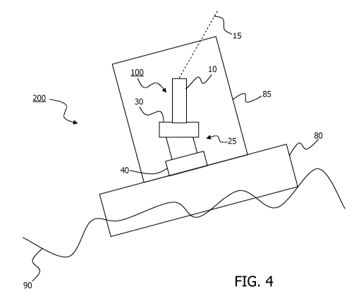
forms part of the probe end 22. FIG. 4 is a graphic illustration of an MS-
LIDAR 100
attached to a buoyant platform, in this case a buoy 80 off-shore, so
constituting an MS-
LIDAR system 200. The MS-LIDAR is covered with a protective cover 85, and the
MS-
LIDAR system is afloat at sea 90.
Numerous alternative uses for the wind speed measurement apparatus of the
present
invention would be apparent to a person skilled in the art.