Note: Descriptions are shown in the official language in which they were submitted.
CA 02858085 2014-11-19
. . =
1
SUPER-RESOLUTION FORMATION FLUID IMAGING
BACKGROUND OF THE INVENTION
1. Field of the Invention
[00011 The present invention relates to imaging sub-surface structures,
particularly
hydrocarbon reservoirs and fluids therein, and more particularly to cross-well
and borehole-
to-surface electromagnetic (EM) surveying.
2. Description of the Related Art
[00021 Cross-well and borehole-to-surface electromagnetic (EM) surveying
have involved
continuous-wave (CW) EM sources placed in one borehole and receivers/sensors
which
detected the phase and amplitude of the EM sigial in a distal borehole, using
multiple source
and receiver positions. The data readings were used to generate a synthetic
time domain
version of the signal, and inferred transit times were used along with
source/receiver
geometry to create a 2D conductivity matrix or image of the inter-well plane
via inversion
with ray-tracing.
100031 Brine which is electrically conductive is everpresent in hydrocarbon
reservoirs, and
the presence of brine attenuated EM signals in proportion to their frequency.
The presence of
brine, as well as the large inter-well distances on the order of 1 kilometer
or more, and
thermal noise limits in conventional receivers caused continuous-wave EM
surveys to require
very low frequency operation, usually about 200 Hz. The low frequency
operating range
which was required severely limited cross-well imaging resolution as it: a) is
in a diffusive
regime, and b) had a very large wavelength. At present, so far as is known, a
spatial
resolution of only 1/10th to 1/20th of the inter-well spacing has been
obtainable.
[00041 Since practical spacing for boreholes in hydrocarbon reservoirs
usually span
hundreds to thousands of meters and such reservoirs are usually associated
with electrically
conductive brines, significant EM signal attenuation across a reservoir has
been encountered.
CA 02858085 2015-04-02
2
Such attenuation is frequency-dependent, such that higher frequencies are
attenuated more
than lower frequencies. Since higher frequencies have shorter wavelengths, and
therefore
afford better imaging resolution, it would be advantageous to operate at the
highest frequency
that still gives a detectable signal after transiting the reservoir region of
interest. However,
the presence, concentration and distribution of brines are generally unknown
prior to
investigation, and the optimal frequency for investigating the reservoir with
EM surveying
could not be determined in advance.
SUMMARY OF THE INVENTION
[00051 Briefly, the
present invention provides a new and improved apparatus for
electromagnetic imaging of a subsurface hydrocarbon reservoir. The apparatus
includes an
electromagnetic energy source emitting pulses of electromagnetic energy to
travel through
the subsurface hydrocarbon reservoir. A plurality Of electromagnetic sensors
in the apparatus
form a measure of the arrival time of the emitted pulses from the
electromagnetic energy
source. The apparatus also includes a processor which analyzes the measure of
arrival time
data from the plurality of electromagnetic sensors to form a representation of
subsurface
features of the subsurface hydrocarbon reservoir. A display in the apparatus
forms an image
of the representation of subsurface features of the subsurface hydrocarbon
reservoir.
[00061 The present invention also provides a new and improved method of
electromagnetic imaging of a subsurface hydrocarbon reservoir. Pulses of
electromagnetic
energy are emitted to travel through the subsurface hydrocarbon reservoir, and
a measure of
the arrival time of the. emitted pulses at a plurality of electromagnetic
sensors is formed. The
measure of arrival time data from the plurality of electromagnetic sensors is
analyzed to form
a representation of subsurface features of the subsurface hydrocarbon
reservoir, and an image
of the representation of subsurface features of the subsurface hydrocarbon
reservoir is then
formed.
CA 02858085 2015-04-02
. .
2a
[0006A] In a broad aspect, the invention pertains to an apparatus for
electromagnetic
imaging of a subsurface hydrocarbon reservoir comprising an electomagnetic
energy source
emitting pulses of electromagnetic energy to travel through the subsurface
hydrocarbon
reservoir, a plurality of electromagnetic sensors forming a measure of the
arrival time of the
emitted pulses from the electromagnetic energy source, a processor for
analyzing the measure
of arrival time data from the plurality of electromagnetic sensors to form a
representation of
subsurface features of the subsurface hydrocarbon reservoir, and a display
forming an image
of the representation of subsurface features of the subsurface hydrocarbon
reservoir.
[0006131 In a further aspect, the invention provides a method of
electromagnetic imaging
of a subsurface hydrocarbon reservoir comprising the steps of emitting pulses
of electromagnetic
energy to travel through the subsurface hydrocarbon reservoir, forming a
measure of the arrival
time of the emitted pulses at a plurality of electromagnetic sensors,
analyzing the measure of
arrival time data from the plurality of electromagnetic sensors to form a
representation of
subsurface features of the subsurface hydrocarbon reservoir, and forming an
image of the
representation of subsurface features of the subsurface hydrocarbon reservoir.
BRIEF DESCRIPTION OF THE DRAWINGS
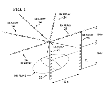
[0007] Figure 1 is a schematic diagram of a transmitter-receiver array for a
borehole to surface
electromagnetic survey.
[0008] Figure 2 is a schematic diagram of a transmitter-receiver array for a
borehole to
borehole electromagnetic survey.
[0009] Figure 3A is a schematic diagram of a transmitter of electromagnetic
energy for an
electomagnetic survey.
CA 02858085 2014-06-03
WO 2013/086270
PCT/US2012/068367
3
100101 Figure
3B is a schematic diagram of a receiver of electromagnetic energy for an
electromagnetic survey.
100111 Figure 4
is a plot of a power spectrum for a square wave electromagnetic energy
signal.
100121 Figure
5A is a schematic electrical circuit diagram of a pulse generator for an
electromagnetic survey.
100131 Figure 5B is an example waveform of a pulse generated by the pulse
generator of
Figure 5A.
100141 Figure
5C is an example waveform of an actual pulse generated by a pulse
generator for an electromagnetic survey.
100151 Figure
6A is a schematic electrical circuit diagram of a semiconductor based pulse
generator for an electromagnetic survey.
100161 Figure 6B is a plot of an example voltage and current waveform
generated by the
pulse generator of Figure 6A.
100171 Figure 7
is a schematic electrical circuit diagram of an equivalent circuit for an
induction sensor for an electromagnetic survey.
100181 Figure 8
is a schematic diagram of an example borehole to borehole
electromagnetic survey according to the present invention.
100191 Figures
9A, 9B and 9C are plots of range versus power for various frequencies and
conductivities of subsurface media.
100201 Figure
10 is a schematic diagram of another borehole to borehole electromagnetic
survey according to the present invention.
100211 Figure
11 is a schematic diagram of another borehole to borehole electromagnetic
survey according to the present invention.
100221 Figure
12 is a schematic diagram of another borehole to borehole electromagnetic
survey according to the present invention.
100231 Figure
13 is a schematic diagram of test results from a borehole to borehole
electromagnetic survey according to the present invention.
CA 02858085 2014-06-03
WO 2013/086270
PCT/US2012/068367
4
DETAILED DESCRIPTION OF THE PREFERRED EMBODIMENTS
100241 By way
of introduction, the present invention involves imaging sub-surface
structures, particularly hydrocarbon reservoirs and fluids therein. The
primary approach is
related to cross-well and borehole-to-surface electromagnetic (EM) survey
technology. The
present invention specifically focuses on fully time-domain data acquisition
using high-power
pulsed EM sources. The present invention can also include spatial over-
sampling and super-
resolution data processing technology to improve image resolution. The present
invention
can also utilize magnetic materials to provide image contrast for regions
containing injected
fluids.
100251 An
improved approach to cross-well EM imaging is provided, using a combination
of high-power pulsed magnetic field sources, fully time-domain signal
acquisition, modem
low-noise magnetic field sensors, spatial oversampling and super-resolution
image
enhancement and injected magnetic nanofluids. The approach provided by the
present
invention generates inter-well images mapping EM signal speed (group velocity)
rather than
conductivity maps. Conventional continuous wave (CW) sources are typically
limited to
about 1500 watts in the down-hole environment. In contrast, pulsed sources
according to the
present invention facilitate simple time-of-arrival data acquisition schemes
and readily
support megawatt transmitters. As will be described, simple current loop
transmit antennas
can be driven from fast-discharge energy sources (capacitors) through
Blumleins, Marx
generators, simple spark gaps, pulse forming LC networks or other sources to
generate the
requisite current and power levels. Higher power levels increase range and/or
operating
frequency in cross-well EM imaging. Using such sources and available modern
magnetic
field sensors (such flux gates, SQUIDs, search coils and the like) with noise
figures in the
pico- to femto-Tesla per Hz range, substantial improvement in the P/N ratio
(transmit power
to receiver thermal noise) are available compared to the prior art. Since the
hydrocarbon
reservoir fluid structure and composition changes only slowly, time is
available to perform
such measurements with relatively small transmitter/receiver positioning
steps. This
`oversampling' is used with super-resolution image deconvolution methods to
improve image
resolution by a factor of three to ten, depending on the amount of over-
sampling performed.
Finally, fluids (typically water) loaded with magnetic nanoparticles can be
injected, which
readily reduces group velocity by five to ten percent compared to pure water.
This fluid can
be imaged against a background of native or previously injected water. In a
water-flood
environment, this is useful to determine dynamic flow paths of injected
fluids. Accordingly,
CA 02858085 2014-06-03
WO 2013/086270
PCT/US2012/068367
the present invention provides EM velocity maps with up a resolution of up to
100th (i. e., 5 to
times greater than previously available) of the inter-well spacing for both
native and
injected fluids.
100261 With the present invention an electromagnetic (EM) pulse with known
characteristics is generated from a high power, pulsed electromagnetic pulsed
EM source at
one location in or near subsurface reservoir. The emitted pulsed EM signal is
transmitted
through the reservoir and recorded at one or more other EM energy receivers
after travel
through the subsurface formations of the reservoir. The EM signal recorded
after transiting
the reservoir differs from the transmitted signal in characteristics (e.g.
time, amplitude, power
spectrum, etc.) that depend on the properties of the intervening medium (e.g.
the reservoir)
and spatial variations of those properties.
100271 In Figure 1, an example arrangement of EM survey locations for a source
array 20
of transmitters Tx disposed in a well bore or borehole 22 to emit EM energy.
In Figure 1, a
suitable number of arrays 24 of EM energy receivers Rx are disposed on the
earthen surface
forming what is known as a borehole to surface array. As also shown in Figure
1, another set
or array 26 of EM energy receivers Rx is disposed in another well borehole 28
spaced from
the transmit borehole 22.
100281
Transmitters Tx may be placed within a borehole or at the surface of the
terrain.
Likewise, receivers Rx may be placed within a borehole or at the surface of
the terrain. More
than one borehole may be employed; and such a configuration is generally
called 'cross-
well'. If only one borehole is employed in conjunction with a surface array,
the configuration
is generally called 'borehole-to-surface'. Both of these configurations are
shown. in Figure 1.
Generally, at least one borehole is employed so that EM signals can traverse
the region of
interest
100291 A multitude of EM energy measurements are performed with different
combinations of transmitter and receiver locations in order to sample various
parts of the
reservoir from different directions, as shown in Figure 2. In Figure 2, a
number of
transmitters 32 in a transmit borehole 34 emit high power pulsed EM energy to
transit
subsurface earth formations to a set of receivers 36 in a receiver borehole
38. Waveform
displays such as those shown at 40a, 40b and 40c represent example readings
from receivers
36 at certain depths as functions of EM signal travel time. Multiple
measurements of
transmissions such as those shown in Figure 2 may be summed or averaged at a
given
CA 02858085 2014-06-03
WO 2013/086270
PCT/US2012/068367
6
transmitter and receiver location pair to improve signal to noise ratios.
Multiple transmitters
(e.g. an array) may be employed, as well as multiple receivers (e.g. an
array). Generally,
transmitters and receivers, either individual or arrays thereof, are placed at
multiple locations
to sample various parts of the reservoir and sampling each part from different
directions.
100301 According to a preferred embodiment of the present invention loop
antennas and
pulsed currents transmitters generate high power EM signals, as shown in
Figures 3.A and 3B.
An example such transmitter 32 (Figures 2 and 3A) includes a loop antenna 44
with a spark
gap 46 is connected to a power supply high voltage module 48. A capacitor 50
is connected
in the loop antenna 44 across the leads from the power supply module 48, and a
load resistor
52 is connected between the power supply module 48 and the spark gap 46.
100311 An example transmitter 32 of Figure 3A is one of a number of such units
as shown
schematically in Figure 2 and is mounted with a tool or sonde 54 lowered by a
supporting
wireline 56 from a vehicle 58 at the surface. The transmitter 32 and other
transmitters shown
in Figure 2 are moved to a number of depths in a transmit wellbore during EM
surveying. A
system control unit 60 associated with the vehicle 58 at the surface sends
signals or pulses
over the wireline as indicated at 62 to provide the energy for the pulses
being transmitted.
Once enabled, the high voltage power supply 48 charges up an energy storage
capacitor 50
through a current limiting resistor 52 until it reaches the break-down.
voltage of a spark-gap
46. The current pulse is discharged through the loop antenna 44, which may
have more than
one turn or loop. A small current loop 45, or sense coil, is supplied to
capture a small portion
of the magnetic field generated by 44; the sense coil 45 is connected to a
coaxial cable 56 that
is used to provide a start-signal to recording apparatus or instrumentation.
It should be
understood that other forms of transmitter may be used, as well.
100321 An example receiver 36 (Figures 2 and 3B) includes a loop antenna 66
connected
to a recording instrumentation or oscilloscope module or card 68. The receiver
36 of Figure
3B is one of a number of such units as shown schematically in Figure 2 and is
mounted with
a tool or sonde 70 lowered by a supporting wireline 72 from a EM logging
vehicle 74 at the
surface. The receiver 64 and other receivers shown in Figure 2 are moved to a
number of
depths in a receive wellbore during EM surveying. Recording and processing
instrumentation associated with the EM logging vehicle 74 at the surface, on
command from
surface recording and processing instrumentation over 'start bus' in wireline
72, sends
records of high energy EM pulses back over the wireline 72 as received after
transit through
the reservoir of interest from the transmit wellbore. The records are then
stored on computer
CA 02858085 2014-06-03
WO 2013/086270
PCT/US2012/068367
7
60 and available for further processing and computerized analysis. It should
be understood
that other forms of receiver may also be used.
100331
According to the present invention, generally square current pulses of high
energy
EM energy and selectable length and rise-time are provided as the generated EM
signal from
the EM energy transmitters. Such EM pulses are advantageous because they are
relatively
simple to generate and control and contain a broad range of frequency
components. Figure 4
shows a representative power spectrum. for both a single (dotted envelope 78)
and repetitive
(arrows 80 at fa and its odd harmonics) pulses of the type emitted by
transmitters according
to the present invention.
100341 Since
practical spacing for boreholes in hydrocarbon reservoirs usually span
hundreds to thousands of meters, and further since such reservoirs are usually
associated with
electrically conductive brines, significant EM signal attenuation across the
reservoir has
almost universally been encountered. Such attenuation is frequency-dependent,
and thus
higher frequencies are attenuated more than lower frequencies. Since higher
frequencies
have shorter wavelengths, and therefore afford better imaging resolution, it
has with the
present invention been advantageous to operate at the highest frequency that
still gives a
detectable signal after transiting the reservoir region of interest. Since the
presence,
concentration and distribution of brines are generally unknown prior to
investigation, the
optimal frequency for interrogating the reservoir cannot be determined in
advance.
Therefore, according to the present invention an inherently broadband EM
source has been
utilized, as is provided by the square pulsed loop antenna transmitter 32
shown in Figure 3A.
100351 A
further advantage provided with the present invention is the ability to
dynamically control the length of the emitted EM energy current pulse.
Reducing the length
of the current pulse increases fa and pushes the envelope towards higher
frequencies,
ensuring that the best possible resolution is obtained when imaging the
reservoir at a given T-
R spacing and signal power. Another useful feature of the signal shape
utilized with the
present invention occurs as a result of the frequency spectrum of the
transmitted energy
includes significant power at 0 Hz. This has value in conjunction with
injected magnetic
nanofluids, as will be described below.
100361 A number of EM sources of a several conventional types may be employed
as long
as such a source includes some time-varying feature that can be used to
determine travel-time
across the reservoir and it has enough power to allow detection at the
receiver location. The
CA 02858085 2014-06-03
WO 2013/086270
PCT/US2012/068367
8
preferred source includes a loop antenna like that shown schematically at 32
in Figure 3A,
which may have multiple conductor turns. This antenna is preferably driven by
a pulsed high
current square wave, as has been described. This current profile may be
conveniently
generated by a pulse forming circuit such as the type known in the art as a
Blumlein circuit or
a type known as a thyristor circuit. It should be understood that suitable
circuits and sources
may of course be used.
100371 An
example Blumlein source is illustrated schematically at 82 in Figure 5A. When
a switch 84 is closed, an ideally rectangular pulse 85 as shown in Figure 58
is applied across
a load 86 that has the same impedance as the pulse generator 82. The amplitude
of the pulse
85 shown in Figure 5B is determined by the charging voltage and the pulse
duration is
determined by the length of the transmission lines and the propagation
velocity, v, of the
electrical signal. Figure 5C is a plot of a single output pulse 88 from the
Blumlein pulse
generator 82 with a 10-ns time duration and an amplitude of 35kV into a 10 ohm
load. A
pressurized spark gap provides a rise time of I ns.
100381 The Blumlein source 82 typically employs a spark gap (although some
versions
may be triggered externally) to initiate the pulse. Energy is supplied by a
high voltage power
supply 90, and energy for the pulse for the purpose of EM surveying according
to the present
invention is stored in a high voltage coaxial cable or similar waveguide
structure like that
shown at 92 in Figure 5A. The length of the EM surveying pulse is determined
by the length
of the coaxial cable 92 and the characteristic impedance and capacitance per
unit length of
the cable determines the delivered current, which arrives at a nominally
constant rate. Since
hydrocarbon reservoirs are often on the order of 10,000 feet below the
surface, a coaxial
cable delivering high voltage to an EM source in a borehole can conveniently
serve as a
Blumlein source like that shown in Figure 5A and generate pulses on the order
of 10
microseconds in length.
100391 An alternative power supply for the EM source can be comprised of a
capacitor
bank and a high voltage switch, usually a thyristor device, as shown
schematically at 94
(Figure 6A). A set of waveforms 96 and 98 (Figure 6B) illustrate voltage and
current,
respectively, for a maximum current pulse in accordance with the present
invention. The
term `thyristor' is used to identify a class of closely related semiconductor
devices including
a SCR (silicon controlled rectifier) and an 1GBT (insulated gate bipolar
transistor). Such
semiconductor devices deliver longer pulses where the length of a Blumlein
source pulse
would not be suitable. Such solid-state switches also offer lower maintenance
and longer
CA 02858085 2014-06-03
WO 2013/086270
PCT/US2012/068367
9
useful lifetimes compared to mechanical or gas discharge switches, with modest
increase in
cost and complexity. It should be noted that a thyristor could be used to
switch the output of
a Blumlein pulse generator, although the more common configuration is to use a
capacitor
bank for energy storage, and to limit or regulate the current output by
selecting or controlling
the impedance of the load device.
100401
Receivers 36 used in the present invention preferably take the form of a
magnetic
field transducer and a time-domain recording device. The recording device may
be as simple
as a zero-crossing discriminator and a fast counter for recording the signal
arrival time, or a
more complex and costly transient recorder or digital oscilloscope module may
be employed.
It should be understood that a may be used. .A simple and generally suitable
transducer is a
loop antenna, as depicted in Figure 3B at 66 representing an example of a
magnetic field
sensor known as a 'search coil'. Search coils generally have many conductor
turns to
increase sensitivity.
100411 It
should be understood that a wide variety of devices may be used to capture the
magnetic field generated by the EM source 42 and convert the sensed magnetic
field readings
into electrical signals that may be recorded for later analysis. Alternative
sensors may
include superconducting devices known as SQUIDs, fluxgates, Hall sensors and
spin-valves.
An exemplary search coil sensor is shown schematically in equivalent circuit
form in Figure
7 at 100.
Spatial and Temporal Oversampling
100421 Super-
resolution image enhancement comprises a further aspect of the present
invention. Imaging resolution is often considered to be bounded by the
diffraction limited
resolution based on the wavelength of the EM probe. However, spatial
oversampling can be
performed in conjunction with an inversion model that includes some knowledge
of
boundaries and structure of the system. This is done to generate images with
resolution well
beyond what would normally be considered to be the diffraction limit ¨
especially if the
sampling is performed in the near-field.
100431 A ready
example comes from induction logging in the oil field. Induction logging
often operates at a frequency around 1 MHz, which would indicate a wavelength
and
resolution on the order of 100 to 1000 meters, depending on the impedance of
the formation.
In practice, however, with appropriate inversion code and knowledge of the
response of
CA 02858085 2014-06-03
WO 2013/086270
PCT/US2012/068367
layered models of rock formations, useful resolution on the order of 1 meter
or less is
routinely achieved.
100441 With the
present invention, cross well EM imaging resolution of up to 1/20th of the
interwell spacing is considered a practical and desirable goal. indeed, in
published literature
a signal source emitting a continuous wave signal at a frequency of about 200
Hz was used
with inter-well spacing of 850 meters to generate images with about 45 meter
blocks. A
distance of 45 meters is a miniscule fraction of the wavelength of a 200 Hz EM
signal (-1000
m in a medium with 0.05 Siemens conductivity). Thus, imaging resolution
depends on
sampling frequency much more that it does on the wavelength of the EM probe.
100451 in
contrast, with the present invention air-coil antennas oriented perpendicular
to
the borehole axis are employed. Further, broadband pulsed operation, and
measurement
spacing of 1 meter or less, especially around the locus of fluid injection and
production are
used.
Data Processing
100461
Tomographic inversion converts data acquired in the field into images of the
reservoir. An example of this processing is described by Abubalcar, et al. ("A
fast and
rigorous 2.5D inversion algorithm for cross-well electromagnetic data", SEG
Extended
Abstracts, 2005 Annual Mtg. Houston, Texas). The processing task requires
solution of a full
nonlinear inverse scattering problem that is usually ill-conditioned and non-
unique. Their
approach employs a finite-difference code as a forward simulator, wherein the
configuration
is numerically discretized using a small number of cells determined by the
optimal grid
technique. The forward problem is solved in each inversion step, and a LU
decomposition
method is used to obtain a solution for all the transmitters simultaneously.
It is to be noted
that the finite-difference approach so used in the prior art, based on coarse
rectangular grid
elements, introduces significant limitations (simplifications) on the forward
solution in order
to speed up the computations.
100471 A
slightly different approach was described in United States Patent No.
5,373,443.
The approach used was based on a solenoid (coaxial with a borehole) source
driven by a pure
sine wave and recording the amplitude and phase of the magnetic field at a
distal borehole
with another solenoid (also coaxial with the borehole). This measurement,
called the
diffusion field, was transformed mathematically into a wave field, and then
signal velocity
CA 02858085 2014-06-03
WO 2013/086270
PCT/US2012/068367
11
between source-receiver pairs was inferred from the wave field. These 'rays'
were used to
tomographically construct a conductivity map of the inter-well region.
100481 in
contrast, with the present invention a pulsed broad band EM source is
employed,
and the received waveform recorded in the time-domain. The travel times for
each source-
receiver pair are measured directly. Fourier transforms may then optionally be
used to
decompose the received signals into their various frequency components and
thereby extract
travel times as a function of frequency. The additional information thus made
available can
be used to improve an inverted velocity image when the medium has material
dispersion ¨
since different frequency components will have different travel times and
diffraction paths in
a ray-tracing model.
100491 in
addition, variable density adaptive (triangular) mesh elements are employed in
a
finite-element model for generating forward solutions, similar to the meshing
approach used
in COMSOL Multi-Physics. This approach increases the mesh density close to the
source
and receiver regions. Since geologic models are normally coarse and blocky, at
least a dual
grid paradigm is employed for generating velocity images of the region of
interest.
[00501 The
objective according to the present invention is to detect and monitor the path
of injected fluids. Thus, as a further refinement/embodiment a streamline
model is employed
for estimating the path and volumes of injected fluids. Streamline simulators
transform a 3D
block model into a number of flow paths of nominally constant flux. While the
paths are
inherently 3D, they can be solved independently as essentially one dimensional
problems,
increasing computational efficiency tremendously. Since
each streamline operates
independently, they can also be treated as a quasi-orthogonal basis set for
comprising the
total flow of injected fluids.
100511 Using
the initial geology model and pre-injection EM data, a forward solution of
the impact (change in EM field and propagation) of fluid injected along each
streamline can
be computed independently. A linear sum of these components can then be
determined that
best fits the observed EM field and travel times observed after injection of
fluid for a period
of time. The results can be mapped back onto the original geologic model to
update fluid
compositions as a function of time as well as indicate appropriate porosity
and permeability
changes in the underlying geologic model. This approach thus employs a tri-
grid modeling
system: Cartesian blocks for the geologic model, streamlines for fluid flow
and variable
CA 02858085 2014-06-03
WO 2013/086270
PCT/US2012/068367
12
triangular meshes for EM transport in an quite different fashion form than
conventional
processing.
Contrast Imaging
100521 Magnetic
contrast enhancement provides a unique signature for injected fluids.
Oil, gas, water, brine and reservoir rocks generally have essentially zero
magnetic character.
Another aspect of the present invention employs injected fluids to change the
magnetic
character of the reservoir volume invaded by such fluids. This may be
accomplished by
loading the injection fluid with pre-fabricated magnetic nanoparticles or non-
magnetic
chemicals that can subsequently react when inside the reservoir to generate
magnetic
materials.
100531 The
group velocity of an EM signal depends on the dielectric perrnittivity and
magnetic permeability of the medium in a very simple way: v = (40412. Thus, by
injecting a
fluid with IA = 10 into a formation with 20% porosity, that reservoir volume
will have an
effective magnetic permeability of 2, and the velocity of an EM wave
traversing it will
decrease by about 30% (1/1.414). This time shift is easily detectable with
modern waveform
recording instruments.
Transient Polarization & Relaxation of Magnetically Modified Geological
Structures
100541 Another
aspect of the present invention involves observing delayed magnetic
transient response of magnetic materials in the reservoir after injecting
fluids. it is to be
noted that magnetic materials channel magnetic flux in much the same way that
good
conductors channel electric fields and electric currents. Thus, the long-pulse
nature of the
EM source employed with the present invention magnetically polarizes modified
regions of
the reservoir in the vicinity of the EM source. EM energy is converted and
stored in the form
of a static magnetic field within the modified portion of the reservoir. When
the pulse ends,
the magnetic field decays, possibly in a resonant fashion, with
characteristics that depend on
the magnetic permeability of the region, as well as the dimensions of the
magnetized region.
This magnetic field can be detected both at the distal receivers (in another
borehole or at the
surface), or alternatively back in the source borehole by using the source
antenna as a
receiver.
100551 The
total magnetic energy stored in the modified region can be inferred from its B-
field magnitude and temporal decay characteristics as observed in the source
region.
Similarly, distal receivers will observe a significantly increased B-field
strength at
CA 02858085 2014-06-03
WO 2013/086270
PCT/US2012/068367
13
frequencies corresponding to the RLC time constant of the magnetized reservoir
volume. In
a sense, the modified reservoir volume acts as a magnetic antenna, and moves
the apparent
EM source closer to the receivers. Give the exponential nature of attenuation
in the reservoir,
flood front anomalies generate significantly increased signal strength at the
receivers.
Detecting such invasive anomalies is another important aspect of the
invention.
100561 Another
aspect of the present invention includes using a series of magnetic pulses
of different lengths at a given source location. Locations with deeper fluid
infiltration take
longer to fully magnetize, and the depth of infiltration can be inferred from
the time to
magnetize that region, as well as the length of the decay time as described
above when the
source is switched off.
100571 Another
aspect of the present invention involves magnetization of the fluid
modified reservoir volume from a distant EM source, which may be in another
borehole, or
may be situated at the ground surface. A surface source is particularly
convenient because it
may be moved around freely and because removing the borehole geometric
constraints,
permits larger and more powerful EM sources.
100581 in
operation, a basic cross-well configuration shown in Figure 8 is utilized in
much
the same way as depicted in Figure 2. EM pulses are generated at each of the
plurality of TX
locations 122 indicated in a first borehole 124, and the EM pulses are
recorded at each of the
plurality of RX locations 126 indicated in a second borehole 128. This matrix
of observations
is used to determine the travel time and signal strength as a function of
frequency between
each of the TX-RX location pairs. Inversion generates a 2D image of the EM
velocity over
the nominally planar surface containing the pair of nominally parallel
boreholes. The EM
velocity in water-filled rock is about four times slower than in oil filled
rock. The EM
velocity of magnetically modified injection fluid or magnetically modified
reservoir volume
can be from fractionally slower to several times slower than water-filled
rock. Conductivity
and magnetic permeability tend to attenuate the EM signal in general, so the
amplitude (or
power) of the signal as a function of frequency indicates the average
conductivity or product
of conductivity and (magnetic) permeability along the line connecting a given
TX-RX
location pair. This information provides another constraint besides simple
group velocity and
can be used during inversion to improve image quality and accuracy. The
process should be
performed prior to injection of fluids to capture the state and structure of
the pristine
hydrocarbon formation. The process is repeated periodically to image the
progress of the
flood front and/or modified reservoir volume as a function of time.
CA 02858085 2014-06-03
WO 2013/086270
PCT/US2012/068367
14
100591 An important advantage to the broad-band pulsed (all the way down to 0
Hz,
Figure 4) EM source used in the present invention essentially makes certain
that some
detectable signal from source to receiver is obtained, regardless of the
distance and
conductivity of the medium. Also made certain is that the highest frequency
that can traverse
the distance and remain detectable is being generated and sampled. The present
invention
therefore provides the maximum signal and resolution (shortest wavelength)
possible in a
given field situation and configuration.
100601 Figure 8 is a diagram of an example EM surveying configuration
according to the
present invention. A simple pulsed source is formed based on a loop antenna,
with a spark-
gap trigger (which could be a thyratron, thyristor or comparable solid-state
switch), and a
Blumlein generator comprised of a long high-voltage coaxial cable connecting
the surface
components to the transmitter 120 in the borehole. Using a typical 50-ohm
coaxial cable a
current pulse proportional in length to the length of the cable (about 1 ns
per foot of cable) is
generated. The power provided to the discharge and downstream components (e.g.
the coil
antenna) is determined by several parameters: the capacitance per foot of the
coaxial cable,
group velocity, characteristic impedance and charging voltage. The current is
primarily
limited by the characteristic impedance of the coaxial cable, and the
discharge power given
by V*I. Using typical relationships for skin depth and attenuation of an EM
signal as a
function of frequency and conductivity of the medium, reasonable ranges can be
computed
over which a detectable signal can be observed using conventional components..
A loop
antenna, constructed as a search coil, with a detection limit of about -100 dB
is assumed as a
receiver 125 in the distal borehole 128. In this simple arrangement the key
parameters are the
charging voltage and the conductivity of the medium, and these factors
determine the
maximum frequency that is readily detected at the distal borehole 128.
Discharge power
scales with the square of the coaxial voltage. With a typical capacitance of
30 pF per foot, a
charging voltage of 1,000 volts yields an output power of about 15,000 watts;
10 kV yields
about 1.5 MW; 100 kV yields about 0.15 GW. Plots of range vs. power under
various
assumptions of frequency and average conductivity of the medium detailed below
in Tables I,
II, and III are set forth in Figures 9A, 9B and 9C, respectively.
CA 02858085 2014-06-03
WO 2013/086270 PCT/US2012/068367
TABLE I - ANHYDRITE
cpf 3.00E-11 capacitance per foot
DL -100.00 db detection limit
sigma 0.00005 S/rn conductivity
freq 1,000,000 Hz frequency
lambda 4.47E+02 m wavelength
atten 0.1 db/rn attenuation
50 ohm impedance
SD 73.57180382 m skin depth
Norm Range 1471.436076 20 SD range
TABLE U ¨ OIL-FILLED ROCK
cpf 3.00E-11 capacitance per foot
DL -100.00 db detection limit
sigma 0.005 S/m conductivity
freq 50,000 Hz frequency
lambda 2.00E+02 m wavelength
atter 0.3 db/m attenuation
50 ohm impedance
SD 32.90231092 rn skin depth
NormRange 658.0462183 20 SD range
CA 02858085 2014-06-03
WO 2013/086270 PCT/US2012/068367
16
TABLE III ¨ BRINE-FILLED ROCK
cpf 3.00E41 capacitance per foot
DL -100.00 db detection limit
sigma 0.5 S/m conductivity
freq 500 Hz frequency
lambda 2.00E+02 m wavelength
atten 0.3 db/rn attenuation
50 ohm impedance
SD 32.90231092 m skin depth
Norm Range 658.0462183 20 SD range
100611 Nominal conductivities for various materials include: anhydrite
(Figure 9A):
.00005 S/m; oil-filled rock (Figure 9B): 0.005 Sim; and brine-filled rock
(Figure 9C): 0.5
S/m. The nominal conductivity of seawater is 5 S/m. Figures 9A, 9B and 9C
present tables
for anhydrite, oil-filled rock and brine-filled rock, respectively, with
operating frequencies
detectable at 1 km.
100621 In a commonly occurring situation (Figure 10) where a reservoir is
produced using
a combination of peripheral horizontal injector wells for water flooding or
pressure
maintenance and vertical producer wells elsewhere in the reservoir, EM TX
arrays 130 in an
injector well 132 and RX arrays 134 in a producing well 136 are deployed as
shown in Figure
10. Other than a non-planar sample volume, operational details are like those
described in
connection with Figure 8 above. The configuration of Figure 10 is useful for
visualizing
progress of an. oil-water contact line or fluid front 138 over time while a
formation 140 in the
reservoir is produced. This information is vital for optimizing reservoir
management.
100631 The configuration shown in Figure 11 provides an improved projection of
the oil-
water contact (or flood front) compared to that of Figures 8 and 10, and is
especially useful in
detecting flood-front anomalies that arise from super-K zones or fracture
corridors as
indicated at 148. EM TX arrays 150 arranged over ground surface 152 and RX
arrays 154 in
a horizontal injector well 156 are deployed as shown in Figure 11. A vertical
producer well is
shown at 160. Production is being had from two reservoirs 162 and 164, each
with a fluid
CA 02858085 2014-06-03
WO 2013/086270
PCT/US2012/068367
17
front as indicated at 162a and 164a, respectively. The configuration
illustrated in Figure 11
may be conveniently implemented where a given hydrocarbon reservoir has
multiple
producing horizons.
100641 A further configuration, shown in Figure 12, may be employed where only
one
borehole as indicated by a horizontal injector well 170 is available for data
to be gathered.
The well 170 contains one or more transmitters 172 and is located in a
hydrocarbon reservoir
174 shown in plan view in Figure 12. .A long duration pulse is emitted from
transmitters in
the well 170 and is used to magnetize the injected fluids and/or the modified
reservoir
volume, and magnetic transients are observed along the borehole 170 containing
the
transmitter(s) 172. High permeability anomalies (super-K or fracture corridors
175) may be
thereby detected from the single borehole 170 by estimating the total magnetic
energy stored
at each station along the borehole as indicated at 177 for several stations. A
fluid front based
on such estimates is schematically shown at 178. Regions with more injection
fluid or
greater modified reservoir volume display larger stored energies, and
therefore higher
remnant field strength and longer decay times. If a second distal borehole is
available as
shown at 176, RX stations may also be deployed and cross-well EM data
gathered, similar to
the configurations described above for Figures 8, 10 and 11.
100651 .A
simplified small-scale version of the present invention was tested in the
field
using a pulsed EM source and loop antennas for the source and receiver. The
apparatus was
configured so as to mimic a borehole-to-surface configuration similar to that
of Figure 11,
and a successful demonstration of travel time shifting of freely propagating
TEM waves
using a small ¨0.5 meter phantom comprised of water loaded with magnetic
nanoparticles.
The EM source comprised ¨50 feet of 50-ohm coax charged to ¨1000 volts, a 1 mm
air
spark-gap, and a 3-turn loop antenna 10 cm in diameter in parallel with a 200
pf capacitor.
This generated a 50 ns square wave pulse with a rise time of ¨2 ns,
superimposed with a 200
MHz sine wave. The receiver comprised a simple 3-turn loop antenna, and the
waveforms
were recorded with a 4 GHz digitizing oscilloscope. The signal delay (travel
time) was
mapped across the ground surface, while the EM signal from the buried source
traversed
unmodified sedimentary material, a water-filled phantom and a magnetic
nanofluid filled
phantom. Using unmodified sediment as a baseline ('before' signal), travel
time delays
consistent with the dielectric and magnetic properties of water and magnetic
nanofluid were
readily observed. The results are set forth in Figure 13.
CA 02858085 2014-09-15
18
[0066] From the foregoing embodiments it can be seen that the present
invention directly
visualizes the path of injected fluids in the reservoir environment, while
generating higher
resolution images of the rock and fluid characteristics and distribution in
the reservoir.
10067] The present invention thus generates information about the spatial
distribution and
composition of fluids in a hydrocarbon reservoir. Since rock and hydrocarbons
generally
both have low dielectric constants, low magnetic permeability and low
electrical
conductivity, EM propagation rates are relatively high and cross-well or
borehole-to-surface
EM travel-times are relatively short. Thus, water, with high dielectric
constant, often coupled
with high conductivity if salty, generates high contrast in a travel-time map.
Injected water,
used to displace hydrocarbons, can be imaged with the present invention, and
after a period
of injection, the paths of high permeability and invasion by such injected
water can be
mapped. In a situation where water has been injected for a long period of
time, it is difficult
to differentiate original (connate) water from injected water. By 'labeling'
new injection
water with magnetic particles, as described, in such a way that the new
injection water
imparts magnetic permeability to the invaded region, it is possible to
differentiate new from
old water. This occurs since magnetic permeability decreases EM propagation
rate and
thereby imparts travel-time contrast in the EM velocity images of the
reservoir region.
[0068] The invention has been sufficiently described so that a person with
average
knowledge in the matter may reproduce and obtain the results mentioned in the
invention
herein Nonetheless, any skilled person in the field of technique, subject of
the invention
herein, may carry out modifications not described in the request herein, to
apply these
modifications to a determined structure, or in the manufacturing process of
the same, requires
the claimed matter in the following claims; such structures shall be covered
within the scope
of the invention as set forth in the accompanying claims.
[00691 It should be noted and understood that there can be improvements and
modifications made of the present invention described in detail above without
departing from
the scope of the invention as set forth in the accompanying claims.