Note: Descriptions are shown in the official language in which they were submitted.
CA 02863396 2014-09-08
IN SITU GRAVITY DRAINAGE SYSTEM AND METHOD FOR EXTRACTING BITUMEN
FROM ALTERNATIVE PAY REGIONS
TECHNICAL FIELD
[0001] The following relates to an in situ gravity drainage system and
method for extracting
bitumen from alternative pay regions.
DESCRIPTION OF THE RELATED ART
[0002] Oil sand is a mixture of bitumen, sand and water. Bitumen is known
to be
considerably viscous and does not flow like conventional crude oil. As such,
bitumen is
recovered using what are considered non-conventional methods. For example,
bitumen
reserves are typically extracted from a geographical area using either surface
mining
techniques, wherein the overburden is removed to access the underlying pay
(e.g., ore-
containing bitumen) and transported to an extraction facility; or using in
situ techniques, wherein
subsurface formations (containing the pay) are heated such that the bitumen is
caused to flow
into one or more wells drilled into the pay while leaving formation rock in
the reservoir in place.
Both surface mining and in situ processes produce a bitumen product that is
subsequently sent
to an upgrading and refining facility, to be refined into one or more
petroleum products such as
gasoline and jet fuel.
[0003] Estimates indicate that approximately 20% of the Canadian Athabasca
oil sands are
close enough to the surface to be mined. The overburden that is removed
typically includes
layers of muskeg, earth and mudstone, to expose the thick deposit of oil sand.
The overburden
is stored for future reclamation of surface land upon completion of the mining
operation. Large
equipment such as excavators and trucks are used to mine and transport the oil
sand ore to an
extraction facility. The trucks deliver the oil sand ore to crushers, where it
is broken down in
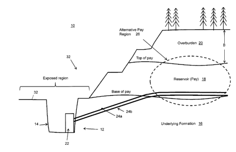
size. At the extraction facility, typically hot water and caustic soda are
added to the crushed
ore in tumblers to transform the dry sand into a slurry. Air is then added to
the oil sand and
water mixture as it is transported to primary separation cells where the
bitumen, sand and water
are separated from one another. Warm bitumen is then separated from the sand
and water and
the bitumen is next de-aerated and sent to storage tanks, then on to a
refinery. Coarse sands
and fine clays are sent to tailings settling ponds, then become fill for the
area that was
excavated by mining. Water from the extraction process and the tailings
settling ponds can
then be recycled.
- 1 -
CA 02863396 2014-09-08
[0004] The above-noted estimates also suggest that approximately 80% of the
Athabasca
oil sands are too deep to feasibly permit bitumen recovery by mining
techniques. These deeper
formations are typically accessed by drilling wellbores into the hydrocarbon
bearing formation.
[0005] There are various in situ technologies available, such as steam
driven or in situ
combustion based techniques. However, currently Steam Assisted Gravity
Drainage (SAGD) is
considered to be the most popular and effective in situ process. SAGD is an
enhanced oil
recovery process whereby a long horizontal steam injection well is located
above a long
horizontal producer well. Injected steam forms a steam chamber above the SAGD
well pair,
heating the reservoir rock and reservoir fluids. Heated bitumen plus condensed
steam flows
down the sides of the steam chamber towards the producer well. The condensed
steam and
bitumen are then lifted to surface with a downhole pump or by gas lift. SAGD
typically operates
at elevated pressures and elevated temperatures, e.g., with temperatures
exceeding 190 C.
Once at surface the bitumen and water are separated from one another in
treatment vessels
that operate at relatively high temperatures (e.g., 170 C). Bitumen is sent
to refineries, while
produced water is recycled. The reservoir rock that once contained the bitumen
remains in
place, and is not produced to surface.
[0006] SAGD has become an increasingly popular method for extracting
bitumen from oil
sand reservoirs that are too deep for surface mining, largely due to the high
recovery factor from
SAGD.
[0007] Accordingly, surface mining is normally used, and considered
economical, when the
pay is relatively close to the surface, i.e. the overburden is relatively
shallow. In other words,
surface mining is not normally used for accessing deep oil sand formations
because the volume
of overburden that would need to be removed is too great for economic recovery
of the bitumen.
[0008] In situ techniques such as SAGD are normally used to access deeper
pay wherein
wellbores are drilled from the surface into the subsurface hydrocarbon-bearing
formation. While
vertical wellbores can be drilled deep enough to access the oil sands, bitumen
recovery from
vertical wells has not been found to be as effective as SAGD, which utilizes
horizontally drilled
wells. Currently, drilling horizontal wells into a shallow formation can be
difficult to accomplish
due to technical limitations such as in the building angle from surface to
horizontal, and turning
the wells into a desired direction.
- 2 -
CA 02863396 2015-01-29
_ = --
LIT
[0009] While
surface mining can access shallow pay, and in situ techniques can access
deeper pay, there can be a band of inaccessible, uneconomical, or "unbookable"
pay that is
considered too deep for surface mining and too shallow for in situ extraction.
Pay can also be
or become unbookable for various other reasons, including without limitation,
being: adjacent to
a surface mine, stranded between surface mining and in situ sites, near bodies
of water such as
rivers or aquifers, in an area having insufficient cap rock or limestone
integrity, adjacent tailing
ponds, etc.
SUMMARY
=
[0010] In one
aspect, there is provided a method of recovering bitumen from a bitumen
reserve, the method comprising: recovering bitumen from an alternative pay
region in the
bitumen reserve via gravity drainage using an inclined horizontally drilled
well drilled from a
drainage pit upwardly into the bitumen reserve; wherein the drainage pit has
been excavated
into an area of an underlying formation that is, at least in part, adjacent to
and underlying the
bitumen reserve; and wherein the alternative pay region comprises a region
unsuitable for
recovering bitumen by surface mining or by in situ recovery using wells that
produce bitumen to
ground level above the alternative pay region.
[0011] In ahother aspect, there is provided a method of planning bitumen
recovery from a
geographical region using a plurality of recovery processes, the method
comprising: determining
a first region comprising at least one area of an underlying formation, the
underlying formation
being adjacent to and at least partially underlying a bitumen-containing
reservoir; determining at
least one alternative pay region, wherein an alternative pay region comprises
a region
unsuitable for recovery of bitumen by surface mining or in situ recovery using
wells drilled from
ground level for producing bitumen to ground level above the alternative pay
region; and
identifying a iodation for excavating at least one drainage pit into the at
least one area of
underlying formation, the at least one drainage pit enabling at least one
inclined horizontally
drilled well to be drilled towards the at least one alternative pay region to
recover bitumen from
the at least one alternative pay region.
[0012] In yet
another aspect, there is provided a system for recovering bitumen from a
geographical area, the system comprising: a drainage pit excavated into an
area of an
underlying formation in a first region, the underlying formation being
adjacent to and at least
partially underlying a bitumen-containing reservoir; at least one inclined
horizontally drilled well
-3-
22671244.1
CA 02863396 2014-09-08
from the drainage pit and towards an alternative pay region included in the
bitumen-containing
reservoir, wherein the alternative pay region comprises a region unsuitable
for recovery of
bitumen by surface mining or in situ recovery using wells drilled from ground
level for producing
bitumen to ground level above the alternative pay region; and production
equipment for
operating the well from the drainage pit to recover bitumen from the
alternative pay region.
BRIEF DESCRIPTION OF THE DRAWINGS
[0013] Embodiments will now be described by way of example with reference
to the
appended drawings wherein:
[0014] FIG. 1 is a cross-sectional elevation view of a bitumen extraction
site for recovering
bitumen from an alternative pay region;
[0015] FIG. 2 is an enlarged partial perspective view of a bottom portion
of a drainage pit
during a well drilling phase;
[0016] FIG. 3 is an enlarged partial perspective view of the bottom portion
of the drainage
pit during a production phase;
[0017] FIG. 4 is a cross-sectional elevation view of a drainage pit
incorporating a SAGD oil
recovery process showing injection and production phases;
[0018] FIG. 5(a) is a cross-sectional elevation view of a drainage pit
incorporating a cyclic
steam stimulation (CSS) oil recovery process during a steam injection phase;
[0019] FIG. 5(b) is a cross-sectional elevation view of a drainage pit
incorporating a CSS
oil recovery process during a production phase;
[0020] FIG. 6 is a cross-sectional elevation view of a drainage pit
incorporating a steam
drive configuration utilizing a vertical injector well;
[0021] FIG. 7(a) is a cross-sectional elevation view of a drainage pit
incorporating a single
well electric heating oil recovery process;
[0022] FIG. 7(b) is a partial perspective view from within a drainage pit,
of a three phase
electric heat oil recovery process;
[0023] FIG. 8 is a cross-sectional elevation view of a drainage pit
incorporating a fuel-plus-
air injection or fuel-plus-oxidant injection oil recovery process;
- 4 -
CA 02863396 2014-09-08
[0024] FIG. 9 is a cross-sectional elevation view of a drainage pit
incorporating a fuel-plus-
air injection or fuel-plus-oxidant injection oil recovery process utilizing
one or more vertical
injector wells;
[0025] FIG. 10 is an aerial plan view of a drainage pit incorporating
multiple wells or well
pairs;
[0026] FIG. 11 is a schematic elevation view of a mapping of bitumen pay
regions in a
geographical area utilizing various extraction methods;
[0027] FIG. 12 is a cross-sectional elevation view of a bitumen extraction
site for
recovering bitumen from an alternative pay region located between a surface
mining site and a
SAGD site;
[0028] FIG. 13(a) is a flow chart illustrating a method for extracting
bitumen from a
geographical area including at least one alternative pay region;
[0029] FIG. 13(b) is a flow chart illustrating a planning method for
extracting bitumen in a
geographical area;
[0030] FIG. 14 is a plot of formation water isotope composition and total
dissolved solids
(TDS) for a formation water sample;
[0031] FIG. 15 is a schematic diagram of a system for analyzing a core
sample to
determine chemical characteristics of uncontaminated formation water;
[0032] FIG. 16 is a flow chart illustrating a method for determining stable
isotope
composition from contaminated formation water extracted from a core sample;
[0033] FIG. 17 is a flow chart illustrating a method for determining TDS
from contaminated
formation water extracted from a core sample;
[0034] FIG. 18 is a schematic cross-sectional view of an example of karst
hydrogeology;
[0035] FIG. 19 is a schematic illustration of a risk matrix for surface
discharge of aquifer
water based on salinity and sulfate levels;
[0036] FIG. 20 is a schematic illustration of a risk matrix for surface
discharge of aquifer
water based on salinity and sulfate levels; and
[0037] FIG. 21 illustrates an application of the risk matrix of FIG. 20 to
a geographical site.
- 5 -
CA 02863396 2014-09-08
DETAILED DESCRIPTION
[0038] It has been recognized that unbookable, stranded, difficult to
extract, uneconomical
using existing extraction methods (e.g., SAGD, surface mining, etc.), or
otherwise "alternative"
bitumen reserves can be recovered from corresponding pay zones or regions by
excavating a
drainage pit into an exposed area of the underlying formation adjacent the
pay; drilling one or
more inclined horizontally drilled wells from the drainage pit and into the
alternative pay region;
and applying an enhanced oil recovery technique to the pay region causing
produced fluids to
drain back into the drainage pit, for example assisted by the influence of
gravity. It can be
appreciated that pay can be considered "alternative" pay based on any one or
more of
geological, technical, and economic constraints. For example, an alternative
pay region could
be otherwise bookable (e.g., accessible via surface mining and/or SAGD), but
considered an
alternative pay region for being more economically extracted using the in situ
gravity drainage
method described herein.
[0039] In some implementations, the drainage pit can be excavated at the
bottom of a
surface mine in a suitable area of exposed underlying formation such as the
Devonian
limestone, or in a naturally or artificially exposed outcrop that is found to
be adjacent or near to
what would be considered an alternative pay region. The location of the
drainage pit is
determined according to the location(s) of pay region(s) in the vicinity that
are deemed to be
less suitable for other extraction techniques such as surface mining or in
situ recovery methods
(e.g., according to geological, technical and/or economic constraints), as
will be explained in
greater detail below. That is, the region is "unsuitable" for surface mining
or conventional SAGD
on account of an economic reason. As such, alternative pay regions are regions
where that are
not suitable for bitumen recovery using surface mining or conventional SAGD
techniques ¨ for
whatever reason.
[0040] The in situ gravity assisted drainage method described herein can
incorporate
various types of oil recovery techniques, including those utilizing electrical
heating, steam,
solvent, combustion, gas drive, etc.
[0041] It has also been recognized that isotopic and chemical data from
formation water
samples taken from drill cores can be analyzed to estimate the chemical and
isotopic
composition of the uncontaminated formation water, according to a process
described below.
This process enables formation water normally contaminated with drilling fluid
to be analyzed
- 6 -
CA 02863396 2014-09-08
without necessarily having access to a sample of such drilling fluid for
comparison purposes.
Additionally, the analysis has been found to be particularly suitable in a
planning stage of the
aforementioned in situ gravity assisted drainage method, to more readily allow
for assessing the
risk of surface discharge of aquifer water, e.g., by using a risk analysis
process also described
below. In this way, the processes for analyzing formation waters from core
samples and
assessing the risk of surface discharge of water can be used to determine
areas which are less
suitable for surface mining but therefore become suitable target alternative
pay regions using
the in situ gravity assisted drainage method described herein.
In Situ Gravity Assisted Drainage Process
[0042] Turning now to the figures, FIG. 1 illustrates a schematic cross-
sectional view of an
example of a bitumen extraction site 10 (which can employ multiple extraction
techniques) that
is configured to incorporate an in situ gravity drainage system 12. The in
situ gravity drainage
system 12 in the example shown in FIG. 1 is installed in a drainage pit 14
that is excavated into
an underlying formation 16 that (at least in part) is adjacent to and
underlying a layer of bitumen
reserves, referred to herein as the "underlying formation" (shown as numeral
16 in FIG. 1). The
layer of bitumen reserves, referenced as 18 in FIG. 1, is also referred to
herein as "pay" 18.
The pay 18 itself underlies and is adjacent to a layer of overburden 20.
[0043] The system 12 includes extraction equipment 22 which is suitable to
the particular
EOR method employed, and one or more inclined horizontally drilled wells 24
directed through
the underlying formation 16 and towards an alternative pay region 26. The
inclined horizontally
drilled wells 24 are drilled using horizontal well drilling techniques with at
least some incline in at
least some of the well 24. The incline can be provided to access pay 18 due to
drilling upwardly
from below and/or to provide at least some incline to get drainage from the
well. As such, the
incline can be of varying degrees including shallow inclines according to the
application. It can
be appreciated that the pay 18 in at least some implementations is not higher
in elevation than
the well 24 and thus the incline can be other than upward in such
implementations.
[0044] In the example shown in FIG. 1, an injector well 24a and a producer
well 24b are
shown in a SAGD configuration of the system 12, in that an injector well 24a
is positioned above
a producer well 24b. However, as contrasted to a conventional SAGD
configuration, the wells
24a, 24b originate from the drainage pit 14 rather than from surface and are
inclined and
horizontally drilled from the drainage pit 14. As illustrated in FIG. 1, the
alternative pay region
- 7 -
CA 02863396 2014-09-08
26 is a zone, region, or portion of the layer of pay 18 (i.e. the subsurface
formation that includes
the bitumen reserve), that would either normally be considered unbookable due
to being in a
region that is unsuitable for surface mining, e.g., too deep to surface mine
or too close to
another geological structure (e.g. Karst, river or aquifer, etc.), and is
unsuitable for conventional
in situ recovery, i.e., too shallow to be feasibly extracted using in situ
operations that recover
bitumen to ground level (i.e. surface) above the alternative pay region, such
as SAGD or CSS.
In other implementations, the alternative pay region is unsuitable for
recovery by surface mining
or conventional in situ techniques on account of economics, i.e. the bitumen
from this region
would be more economically extracted using the in situ gravity drainage system
12 described
herein.
[0045] The drainage pit 14 is excavated into an exposed region 30 of the
underlying
formation 16 at a particular site 32. The exposed region 30 can be part of a
naturally occurring
outcrop, riverbank, etc., of the extraction site 10. The exposed region 30
could also become
artificially exposed by deliberately excavating to the underlying formation 16
to create the
exposed region 30. It has been found that the drainage pit 14 is
advantageously incorporated
into an existing or planned surface mining operation at the site 30, such that
surface mining
occurs at the site 32 with knowledge of the location of one or more
alternative pay regions 26
that can be accessed from the bottom of the surface mine. It can be
appreciated that the
exposed region 30, when part of a surface mining site 32, can be pre-planned
or can be
incorporated into an existing surface mining site 32 after determining that
there exists a suitable
alternative pay region 26 adjacent or near to the site 32. The system 12 can
therefore also be
referred to as a mine in situ gravity drainage system 12 in applications
located within an existing
or planned surface mining site 32.
[0046] FIGS. 2 and 3 illustrate partial enlarged perspective views of a
lower portion 40 of
the drainage pit 14, during drilling and production phases respectively.
[0047] After excavating the drainage pit 14, and determining where the
horizontal wells 24
will be located (e.g., by conducting typical computer simulations using
geological and reservoir
data), the corresponding locations on the wall of the drainage pit 14 are
prepared for drilling,
including providing infrastructure for water and electricity, as is known in
the art. The drilling rig
is then installed at the location and drilling commences subject to requisite
inspections. In the
example shown in FIG. 2, a drilling rig 42 is horizontally installed in the
drainage pit 14,
- 8 -
CA 02863396 2014-09-08
=
however, it can be appreciated that various other drilling configurations can
be used to achieve
the inclined horizontally drilled wells 24, such as directional drilling. The
drilling phase includes
steps of drilling, then running, and cementing new casing, which are repeated
until the drill bit
reaches the desired well length, by adding new drill pipe as the well
lengthens. The drainage pit
14 is also prepared for pumping drilling fluid down the interior of the drill
pipe, which circulates
through the drill bit, and returns via the annulus between the pipe and the
borehole to be
cleaned (i.e. processed to remove drilled particles) and cleaned fluid pumped
back down the
drill pipe. It can be appreciated that measurement while drilling (MWD)
technologies and bends
can be utilized to steer the bit and the resultant well 24 in a particular
direction. When the
drilling is completed, and deemed to be ready for production or injection,
production casing is
installed, which extends from the entry of the borehole to the end of the well
24 and is cemented
in place. Alternatively, the pay section of the well can be lined with a
slotted liner or other form
of sand control that is not cemented into place. The liner can also utilize
packers and inflow or
injection control devices (ICDs) that divide the injection or producer wells
into segments. The
drilling rig 42 can then be moved and used to drill the next well 24 in the
drainage pit 14.
[0048] In FIG. 2, drilling equipment 42, such as drilling rigs mounted to a
wall of the
drainage pit 14 in a horizontal configuration, is used to drill the one or
more inclined horizontally
drilled wells 24 (three being shown in FIG. 2 for illustrative purposes only).
[0049] After drilling the wells 24, production equipment 22 for the system
12 is installed in
one or more production facilities 44 for operating the one or more inclined
horizontally drilled
wells 24 as illustrated in FIG. 3. Completing a well for production can
involve several steps, as
is known in the art. For example, a service rig is moved into location and
used to perform a
cleanout trip to the total length of the well 24 to ensure that there is no
cement or debris left
inside the production casing. Alternatively, the well can be completed by the
drilling rig after the
production casing cement has hardened. To access the target pay 18,
perforating is performed
to create holes through the casing and cement, which can be performed before
or after
production tubing is installed in the well 24. Alternatively, the pay section
of the well can be
lined with a slotted liner or other form of sand control that is not cemented
in place. The liner
can utilize packers and inflow or ICDs that divide the injection or producer
wells into segments.
The production tubing is then installed using the service rig. In addition to
production tubing, the
operator may install downhole instrumentation that can include temperature
sensors, pressure
- 9 -
CA 02863396 2014-09-08
sensors or fiber optic cable. Once the tubing has been landed, a wellhead is
installed over the
production casing.
[0050] It can be appreciated from FIGS. 2 and 3 that various configurations
and arrays of
wells 24 can be employed, depending on the EOR technique being used, the size
and location
of the alternative pay region 26, and other application-specific
considerations such as capacity.
The equipment 22 in the production facility 44 shown in FIG. 3 includes one or
more outlet paths
46 (e.g., piping) for recovered bitumen to be pumped out of the drainage pit
14 for downstream
transportation and/or processing. The bitumen and accompanying fluids that are
collected in
the drainage pit 14 can be processed at least in part in the drainage pit 14
or can be transported
to a treatment facility outside of and away from the drainage pit 14.
[0051] FIGS. 4 through 10 illustrate example configurations illustrating
various EOR
processes that can be used in the system 12.
[0052] In most cases, bitumen is extracted using heat generated by a source
associated
with the EOR process being utilized. For example, various steam-based
processes exist,
including SAGD, single well CSS, and steam drive.
[0053] FIG. 4 illustrates a SAGD process that can be deployed in the
drainage pit 14
instead of or in addition to other EOR processes such as CSS, electric
heating, combustion, etc.
Compared to traditional SAGD implementations, in the configuration shown in
FIG. 4, an injector
well 24a and a producer well 24b (forming a well "pair" 24a, 24b) are
horizontally drilled from the
wall of the drainage pit 14 at an incline rather than directionally drilled
from surface. This allows
a SAGD configuration to be used at depths that are not traditionally
accessible to SAGD well
pairs due to limitations on building angles from surface to horizontal, and
turning the wells in a
desired direction. Otherwise, the SAGD process can be employed according to
usual methods
whereby steam is injected into the injector well 24a and heated bitumen flows
towards and into
the producer well 24b thereafter flowing in to the drainage pit 14. Similar to
other EOR
processes, the steam injection facilities can be located within or outside of
the drainage pit 14.
[0054] FIGS. 5(a) and 5(b) illustrate a CSS process, often referred to as
the "huff-and-puff'
method, that can be deployed in the drainage pit 14. In FIG. 5(a), a single
well 24 is shown into
which steam is injected during a steam injection phase. The steam injection
phase involves
injecting steam into the well 24 for a period of weeks to months after which
the well 24 is
allowed to sit for days to weeks to allow heat to soak into the formation
containing the pay 18.
- 10-
CA 02863396 2014-09-08
The production phase, shown in FIG. 5(b), follows the soaking phase in which
heated bitumen
drains from the well 24 into the drainage pit 14, which can employ the use of
a pump.
[0055] As noted above, the steam injection facilities can be incorporated
into the equipment
44 (see FIG. 3) and thus be located in the drainage pit 14, or such facilities
can be located
outside of the drainage pit 14. For example, as shown in FIG. 6, steam can
also be introduced
using vertical injector wells 24a, to heat the reservoir above a producer well
24b in a SAGD
configuration. It can be appreciated that steam, solvent, electricity, air
(for combustion), etc.,
which are used in the injection phase of a respective EOR process, could also
be added either
inside or outside of the drainage pit 14.
[0056] Other heat sources can be used to implement an EOR process in the
drainage pit
14. For example, FIG. 7(a) illustrates a single well electric heating process
in which an
electrical heat source 49 is used to heat bitumen surrounding a well 24c
having insulated
surface casing. It can be appreciated that since water is conductive, the
equipment 22 should
be operable to dissipate current from the produced bitumen. Electric heating
can utilize direct
current (DC), single phase alternating current (AC), or three-phase AC. Three-
phase AC power
can be chosen for higher power applications where constant torque is desired.
[0057] In some implementations, the electrical heat source 49 is provided
by an electrical
heating system which disposes an electrical heater cable in the well 24c. The
electrical heater
cable includes a wire surrounded by insulation (e.g., mineral insulation) and
disposed within a
metallic sheath. The wire is electrically coupled to a power source and a
controller and, in this
respect, is configured to effect heating of the pay 18 surrounding the well
24c by conduction.
An example of a suitable heater cable is a mineral-insulated ("MI") heater
cable, which includes
an electrically conducting core surrounded by a metallic sheath (e.g., a 304L
sheath) with a
mineral insulation layer (e.g., magnesium oxide) disposed between the metallic
sheath and the
core. In some implementations, the heater cable can include relatively hotter
and relatively
colder sections by using different materials in different sections of the
cable. In this way,
different heating rates can be provided for different portions along the well
24c.
[0058] The heater cable utilized by the electrical heat source 49 can be
deployed within a
coiled tube and multiple cables can be deployed within such a coiled tube. The
cables can be
mounted to a support rod for maintaining positioning of the cables. The coiled
tube is typically
-11-
CA 02863396 2014-09-08
deployed from a reel or other suitable feeding mechanism, which would be
positioned within the
drainage pit 14.
[0059] It can be appreciated that while FIG. 7(a) illustrates a single well
electrical heating
configuration which heats the pay 18 near the well 24, other electrical
heating based methods
can also be employed, for example, inter-well electrical heating which heats
the pay 18 in inter-
well regions between well pairs as shown in FIG. 7(b). As is known in the art,
inter-well electric
heating applies heating directly to the target formation by relying on current
flow between
electrode wells and is typically used to heat portions of the pay 18 some
distance from the
wellbores. In the configuration shown in FIG. 7(b), three wells 24c having
insulated surface
casing are each heated using a different electrical phase, e.g., 0 , 120 , and
240 as illustrated.
A fourth well can also be included and operated using the 07360 phase.
[0060] Combustion can also be a source of heat for extracting bitumen. FIG.
8 illustrates a
combustion-based process in which the injector well 24a is injected with a
combustible fuel and
oxidant (e.g., air), which is ignited to heat the pay 18 between injector well
24a and the
production 24b, e.g., via combustion and condensing zones as is known in the
art.
[0061] FIG. 9 illustrates a combustion-based process in which one or more
vertical injector
wells 24a are used to inject fuel plus oxidant into the pay 18. As illustrated
in FIG. 9, the
bitumen is produced into well 24b, similar to what is show in FIG. 6. It can
be appreciated that
the configurations shown in FIGS. 8 and 9 can also be used to implement a
solvent injection-
based oil recovery process, e.g., using propane, butane, CO2, etc.
[0062] As indicated above, any one or more EOR processes can be deployed
within/from
the drainage pit 14, including combinations of multiple process types. FIG. 10
illustrates a
series of wells 24 or well pairs 24a, 24b that can be deployed along the
length of a wall of the
drainage pit 14. For example, the drainage pit 14 can include multiple
electrically heated single
wells 24, multiple well pairs 24a/24b utilizing SAGD, CSS, combustion, and/or
electrical heating,
etc.
[0063] In addition to the thermal-based processes illustrated in FIGS. 4 to
10, it can be
appreciated that non-thermal processes can also be utilized. For example,
solvent-based
processes can be deployed alone or in combination with one or more thermal
processes.
Typical solvents include light hydrocarbons such as methane, ethane, and
propane; up to
heavier hydrocarbon molecules such as naphtha having 5 to 12 carbon molecules.
- 12 -
CA 02863396 2014-09-08
[0064] Carbon dioxide flooding is another example of a non-thermal process
that can be
used. Various other processes include, without limitation, flue gas flooding,
non-condensable
gas (NCG), the use of surfactants, alkaline chemicals, microbes, etc. It can
also be appreciated
that processes can be combined wherein heat is added to solvents, carbon
dioxide, or soapy
water; or wherein combustion follows steam, etc.
[0065] Regardless of the recovery process(es) employed in the drainage pit
14, bitumen
along with accompanying fluids (e.g., water, solvent, gases, etc.) are caused
to flow through the
inclined horizontally drilled wells 24 into the drainage pit 14 to be
transported to a treatment
facility (or be treated within the drainage pit 14 if applicable). As noted
above, injection facilities
for which ever process or processes are utilized in the system 12 can be
located inside or
outside the drainage pit 14 and thus any solvent or other materials can also
be injected from
inside or outside of the drainage pit 14.
[0066] While the system 12 shown in FIG. 1 can be applied to existing sites
32 and/or
previously determined or existing exposed regions 30, the system 12 is
advantageously utilized
to extract pay from alternative pay regions 26 identified when planning sites
for yet-to-be
extracted reserves. For example, as illustrated in FIG. 11, in addition to
mapping 47 out
suitable surface mining sites 32 and SAGD sites 50a, 50b for a geographical
area 46, one or
more alternative pay regions 26 can be identified and included in the planning
phase. In the
example shown in FIG. 11, a first alternative pay region 26a is identified
between a river 48 and
a first SAGD site 50a. The first alternative pay region 26a could also be in
an area having a
naturally occurring or feasibly accessible exposed region 30 of an underlying
formation 16 (e.g.,
via some overburden excavation) to allow for excavation of a drainage pit 14.
A second
alternative pay region 26b surrounding a mine site 32 is also illustrated by
way of example to
demonstrate that multiple portions of an alternative pay region 26b can be
accessed from the
same mine site 32 when applicable. For example, the same drainage pit 14 can
be excavated
to be large enough to reach multiple portions of the alternative pay regions
26b by drilling in
opposite directions, or multiple drainage pits 14 can be excavated at the mine
site 32. Similarly,
multiple distinct alternative pay regions can also be accessed from the same
mine site 32. It
can be appreciated from FIG. 11 that SAGD sites 50 can also be considered in
planning
alternative pay regions 26 to be exploited, e.g., in order to reach between
the mine site 32 and
the SAGD site 50, and/or to facilitate or complement the production of the in
situ wells 24 due to
the potential to reach towards a planned SAGD site 50 and thus contribute to
the heating of the
- 13-
CA 02863396 2014-09-08
reserves in that area. Similar considerations are also applicable to existing
or planned sites
using other EOR methods such as CSS.
[0067] FIG. 12 illustrates one example of a bitumen extraction site 10a
that can be
retrofitted to include the system 12 to access alternative pay regions 26, or
can be planned such
that it incorporates the system 12 at a particular stage of production. In the
example shown in
FIG. 12, an alternative pay region 26' is identified as being stranded between
a surface mine
region 32' and a SAGD region 50'. As can be appreciated from this
illustration, whereas the
mine region 32' includes pay 18 that is beneath overburden 20 having a depth
of approximately
distance A (e.g., 30-50 m), making the pay 18 suitable and economical for
surface mining
operations in that area; and the SAGD region 50' includes pay 18 that is
beneath overburden 20
having a depth of approximately distance C (e.g. 70 m) or greater, making the
pay 18 suitable
for in situ recovery; there is a band of pay 18 that is beneath overburden 20
having a depth of
approximately distance B (e.g., 30 - 50m < B < 70 m). When a region of pay 18
is beneath an
overburden of distance B, and determined to be unsuitable (or less suitable)
for surface mining
and in situ techniques, such a region can be considered for recovery using the
in situ gravity
drainage system 12 described herein, rather than being left behind as being
considered
unbookable pay 18.
[0068] In addition to being considered unbookable due to the depth of the
pay 18, the
alternative pay region 26' can also be identified as being suitable for the in
situ gravity drainage
system 12 described herein for other reasons. For example, also illustrated in
FIG. 12 is a Karst
hole 70. A Karst hole 70 or other Karst feature such as fractures 71 or faults
emanating from a
Karst hole 70 in the vicinity of the alternative pay region 26' can make the
underlying formation
16 unsuitable for high pressure recovery or mining operations by increasing
the risk of seepage
of gas or fluids to the surface. On the other hand, Karst holes 70 can create
areas having a
relatively thicker band of pay 18 due to the depression in the formation.
Since the system 12
can operate using a low pressure in situ technique, the inclined horizontally
drilled wells 24 can
be drilled into and through such a Karst feature as illustrated in FIG. 12.
[0069] Moreover, since surface mining typically includes the development of
several
benches 54 to facilitate removal of excavated overburden 20 and pay 18 using
excavation
equipment (not shown), the alternative pay region 26' can include or otherwise
be adjacent or
- 14 -
CA 02863396 2014-09-08
beneath such benches 54, wherein the system 12 enables the recovery of
additional pay 18 that
would otherwise be considered unbookable in the example shown.
[0070] The mine region 32', as illustrated in FIG. 12, can also include
multiple drainage pits
14 to access multiple alternative pay regions 26 in different directions. It
can be appreciated
that as discussed above, multiple sets of one or more wells 24 can also be
drilled from the same
drainage pit 14.
[0071] It has also been recognized that in at least some embodiments, the
production of the
alternative pay region 26' using the system 12 can also enhance or otherwise
complement
production of a nearby SAGD site 50 by effectively contributing heat to that
region. Such
additional heating can therefore contribute to additional recovery in, for
example the producer
well of a SAGD well pair 24a/24b. Similarly, less viscous bitumen in the pay
18 that is heated
from the in situ operation can also contribute to additional recoveries in one
or more of the wells
24 operated in the system 12.
[0072] Turning now to FIG. 13(a), a flow chart illustrating a method for
recovering bitumen
from a geographical area is shown, in which the recovery includes bitumen
recovered from at
least one alternative pay region 26. At step 100 regions are identified that
already include or
can be excavated to include (e.g., subsequent to mining) an exposed region 30
of the
underlying formation 16 that enables the excavation of a drainage pit 14. At
step 102, the
geographical area near the potential areas of exposed underlying formation 16
are analyzed to
identify alternative pay regions 26, e.g., those that are reachable using the
system 12 and would
not otherwise be bookable pay 18 recovered using surface mining or surface-
based EOR
techniques.
[0073] It can be appreciated that steps 100 and 102 can be initiated as
part of a planning
phase prior to bitumen recovery using one or more traditional techniques (i.e.
prior to surface
mining and/or in situ production), as a post-recovery phase to conduct
additional recovery, or in
identifying alternative pay regions 26 outside of a traditional bitumen
recovery plan (e.g., to take
advantage of naturally occurring outcrops or recover additional pay 18 at or
near otherwise
unsuitable regions). It can also be appreciated that, as shown in FIG. 13(a),
steps 100 and 102
may be conducted in parallel or serially in any order depending on the
information and planning
methodology employed.
-15-
CA 02863396 2014-09-08
[0074] At step 104 it is determined whether or not the potential exposed
region(s) of
underlying formation 16 is/are currently exposed. For example, an exposed area
can already
exist in a current surface mining site 32 or in a naturally occurring outcrop.
If the potential
exposed area 30 is not yet exposed, e.g., currently has at least some
overburden 20 or other
material above the area 30, it is determined at 106 whether or not the area
including and
surrounding the potential exposed area 30 is suitable for surface mining. If
not, the overburden
is excavated at 110 to expose the layer of underlying formation 16. It can be
appreciated that
step 110 can include areas near geological features that are unsuitable for
surface mining or in
situ techniques, and which require at least some excavation of the overburden
20 in order to
further excavate a drainage pit 14.
[0075] If the potential exposed area 30 is deemed at step 106 to be
suitable for surface
mining, surface mining operations are conducted at step 108, which would
eventually allow for a
region of the underlying formation 16 to be exposed.
[0076] Step 112 is conducted once there is a suitable exposed area 30, at
which time a
drainage pit 14 is excavated. Once the drainage pit 14 has been created, one
or more wells are
horizontally drilled from the drainage pit 14 at an incline along at least a
portion thereof and into
the alternative pay region(s) 26 at step 114. It can be appreciated that in
step 114, equipment
22 suitable to the chosen in situ gravity drainage technique is selected and
installed. For
example any one or more of the EOR processes shown in FIGS. 4 through 10 can
be utilized,
including combinations of multiple process types.
[0077] At step 116 the one or more wells 24 are operated from within the
drainage pit 14 to
recover the additional bitumen reserves from the alternative pay region(s) 26.
As shown in
dashed lines in FIG. 13(a), ongoing monitoring of the conditions in the
drainage pit 14 and/or
wells 24 can also be conducted, e.g., to determine, using the isotopic and
chemical analyses
described below.
[0078] FIG. 13(b) illustrates an example of a planning method for
extracting bitumen in a
geographical area which begins at step 130. Geological and reservoir data 132
associated with
the geographical area is obtained and used to determine at step 134 whether or
not the
geographical area currently being assessed is surface mineable. If so, surface
mining
operations can be conducted at step 136. If not, the geological and reservoir
data 132 and
drilling and production data 138 is used in step 140 to determine if the
geographical area
- 16 -
CA 02863396 2014-09-08
currently being assessed can be accessed using a SAGD method. If so, SAGD
operations can
be conducted at step 142. If not, the geographical and reservoir data 132 is
further utilized at
144 to determine if the geographical area currently being assessed
nevertheless has what can
be considered good pay and is thus a good reservoir. If not, the process
results in no project at
146. If so, isotopic and chemical data from formation water samples taken from
drill cores can
optionally be analyzed at A (see flow chart in FIG. 16) to estimate the
chemical and isotopic
composition of the uncontaminated formation water, which may further include
assessing risk
using a risk matrix as discussed below. At step 148 it is determined whether
or not the
geographical area being currently assessed is adjacent a mine or an outcrop.
If not, an
alternative (alt) EOR process can be considered at 150. However, if the
geographical area
currently being assessed is adjacent a mine or outcrop, the in situ gravity
drainage method
described herein is conducted at step 152.
Analyzing Isotopic and Chemical Data from Formation Water Extracted from Drill
Core
[0079] As discussed above, as part of the planning stages for recovering
bitumen from a
geographical region, for example in steps 100 and 102 of FIG. 13, various
analyses can be
conducted, to determine the suitability of certain sub-regions for
corresponding extraction
techniques, such as surface mining and traditional in situ techniques such as
SAGD. In
assessing the suitability of such sub-regions, various other unsuitable
regions can also be
identified, wherein the above-noted in situ gravity drainage method can be
used to recover
bitumen from alternative pay regions 26.
[0080] One such analysis, described below, enables water samples taken from
drill core to
be analyzed to estimate the chemical and isotopic composition of
uncontaminated formation
water, even though the water sample from the drill core is contaminated by
drilling fluid. That is,
because the water sample is taken from a drill core, the sample of water is
contaminated by
drilling fluid that was used to extract the drill core using drilling
equipment. However, the
techniques described herein can be used on such drill core water samples to
determine
characteristics of the formation water in an uncontaminated state. As will be
explained in
greater detail below, the characteristics of the formation water, e.g.,
chemical and isotopic
composition, thus determined can be used to assess the risk of surface
discharge of aquifer
water in particular geographical regions and thus assist in identifying
regions of pay that are
more suitably recovered using the in situ gravity drainage method described
above.
- 17-
CA 02863396 2014-09-08
[0081] It can be appreciated that the method for estimating the chemical
and isotopic
composition of formation water extracted from core samples can be used in any
application
where knowledge of the composition of the formation water is desired, and the
utilization of the
method in identifying alternative pay regions 26 is but one illustrative
example of an application
of this technique.
[0082] The following method permits the prediction of the chemical
composition of formation
water based on an analysis of contaminated formation water samples taken from
a drill core,
without requiring information about the drilling fluid, also referred to a
drilling "mud". The
method predicts isotopic and chemical composition of formation water based on
an analysis of
isotopic and chemical data from the contaminated formation water samples, and
information on
the local meteoric water line.
[0083] The technique described herein addresses the problem that formation
water from a
drill core are typically contaminated by drilling mud that is used during
drilling. Conventionally,
in order to estimate the chemical composition of formation water from such
contaminated
formation water samples, a sample of the drilling mud that was used had to be
analyzed for its
chemical composition. Based on the analysis of the drilling mud, data from the
contaminated
formation water samples were corrected to yield characteristics of the
formation water. An
issue with this technique is that drilling mud samples are often not retrieved
or stored for later
use. Moreover, often it is not known at the time of taking a core sample that
the core will be
used for a later formation water analysis. Another technique to analyze the
chemical
composition of formation waters is to drill an observation well. However,
observation wells
require additional time and resources, which is not always feasible.
[0084] The technique described herein allows contaminated formation water
samples to be
analyzed to estimate the chemical and isotopic composition of the
uncontaminated or "virgin"
formation water, without requiring a sample of the drilling mud that was used.
As described in
greater detail below, the technique recognizes that the intersection of a line
fitted to a plot of
particular isotopes and the meteoric water line can estimate the
decontaminated isotopic
composition of the formation water, without having to rely on a separate
analysis of the drilling
mud. Given that an estimate of the isotopic composition of the uncontaminated
formation water
is now known, the total dissolved solids (TDS) as well as various other
chemical components
- 18 -
CA 02863396 2014-09-08
can be plotted against the 6180 line to estimate uncontaminated TDS values,
i.e. where the TDS
line has a value of 6180 that is equal to the uncontaminated 6180 level.
[0085] An example of the formation water analysis is illustrated in a plot
200 shown in FIG.
14. Contaminated formation water samples are analyzed for 6180 and 62H
isotopes, yielding
several data points 202 (diamonds plotted in FIG. 14) to enable construction
of an isotope
mixing line 204 which defines 6180 and 62H isotope compositions for mixtures
of formation fluid
and drilling mud. It can be appreciated that the contaminated formation water
of the drill core is
assumed to include a mixture of both formation fluid and drilling mud. 6180
concentration within
the formation water is then estimated based on the intersection 206 of the
isotope mixing line
204 with a local meteoric water line 208. As illustrated in FIG. 14, to obtain
the isotope mixing
line 204, the 6180 and 62H isotopes are plotted (e.g., diamonds 202) on an X-Y
axis and a
straight line is fitted though these data points 202 and extended until it
crosses the local
meteoric water line 208, which is predetermined and typically well established
in many
geographical areas. The point of intersection 206 marks the decontaminated
isotopic
composition of the formation water.
[0086] Based on the estimated 6180 concentration within the formation
water, other
chemical composition information of the formation water within the drill core
can be obtained
based on the chemical composition information of the contaminated formation
water samples
taken from the drill core. Such information can be defined by another mixing
line 210
constructed from measurements of the chemical composition characteristic of
various samples
of the contaminated formation water samples taken from the drill core, such as
the TDS content.
In FIG. 14, TDS data points 212 are plotted and used to form the TDS mixing
line 210. The
intersection 214 of the TDS mixing line 210 and a line 216 perpendicular to
the X-axis which
crosses through the intersection 206 of the water line 208 and the isotope
mixing line 204 gives
an estimate of the TDS in the virgin formation water, in this example
approximately 45 000
mg/L.
[0087] FIG. 15 illustrates a schematic diagram of an example of a formation
water analysis
system 250. In the example shown in FIG. 15, the system 250 includes formation
water
extraction apparatus 254, which operates on a core sample 252 as is known in
the art, to obtain
a contaminated formation water sample 256. The contaminated formation water
sample 256 is
then analyzed by chemical analysis apparatus 258 such as a chromatography
system and an
- 19 -
CA 02863396 2014-09-08
. .
autotitration system, to determine the data points that can be analyzed by a
computing device
260 in order to generate an analysis output 262 such as a plot, report, etc.
It can be
appreciated that the chemical analysis apparatus 258 and computing device 260
are delineated
as shown in FIG. 15 for illustrative purposes only and such devices may be
integrated in other
configurations, e.g., wherein the computing device 260 forms a portion of the
chemical analysis
apparatus 258.
[0088] FIG. 16 illustrates a method of analyzing formation water
extracted from a drill core
sample to estimate stable isotope composition of the uncontaminated formation
water. As
shown in dashed lines in FIG. 16, the method of analyzing formation water may
be performed in
connection with a planning process for determining alternative pay regions 26
by following "A" in
FIG. 13(b). At step 300 a core sample 252 is obtained and contaminated
formation water is
extracted from the core sample 252 at step 302 using the extraction apparatus
254. The
contaminated formation water is then analyzed at step 304 to determine the
5180 and 52H
isotopes that can be plotted at step 306 in order to generate the isotope
mixing line 204.
Additionally, the local meteoric water line 208 is determined at step 308. The
local meteoric
water line 208 can be determined at the time of conducting the chemical
analysis, or can be
predetermined and stored in the computing device 260 or chemical analysis
apparatus 258. For
example, tables of local meteoric water lines can be pre-stored for subsequent
access
according to a location that can be associated with the particular core sample
252 being
analyzed. The local meteoric water line 208 is plotted at 310, which enables
8180 concentration
to be determined in step 312 based on the intersection 206 of the isotope
mixing line 204 and
the local meteoric water line 208 as shown in FIG. 14. This intersection 206
can be plotted as
illustrated in FIG. 14, or provided in another form as an output, e.g., as an
item in a report.
[0089] As discussed above, further analyses can be conducted using
the contaminated
formation water sample 256, for example, to determine TDS content. At step
314, it is
determined whether or not such further analyses are to be conducted. If not,
the process ends
at 316, e.g., by storing and/or outputting results. If further analyses are to
be conducted, a
further process can be initiated at A, which begins in the flowchart shown in
FIG. 17.
[0090] Turning now to FIG. 17, a process is illustrated for
determining TDS from the
extracted contaminated formation water sample 256. At step 350 the
contaminated formation
water sample 256 is analyzed for TDS content, which enables TDS data points
212 to be plotted
- 20 -
CA 02863396 2014-09-08
in order to generate a TDS mixing line 210 as shown in FIG. 14. As shown in
FIG. 16, with an
isotope mixing line 204 having been generated, a line 216 perpendicular to the
intersection of
the isotope mixing line 204 and the local meteoric water line 208 is generated
at step 356 to
enable the intersection 214 of this perpendicular line 216 and the TDS mixing
line 210 to be
determined at 358, which enables the TDS content to be estimated at step 360.
It can be
appreciated that the results of the further analysis shown in FIG. 17 can also
be plotted as
shown in FIG. 14, stored for subsequent use, or output in a report or as
another form of data.
[0091] As illustrated in FIGS. 14 and 17, the analysis of the contaminated
formation water
sample 256 as described above can be used to determine the TDS concentration
and the stable
isotope composition of the uncontaminated formation water in oil sands
reservoirs. The
technique described herein utilizes two end-member mixing relationships
between the stable
isotope compositions of drilling fluids and formation waters from mechanically
extracted
formation water samples 256 to calculate the formation water TDS, 62H and 6180
values. This
technique provides an inexpensive and robust ability to characterize the
properties of reservoir
formation waters, which takes advantage of the ubiquity of drill core samples
252, while not
requiring drilling mud samples. The ability to characterize aqueous fluids
within bitumen-
saturated reservoirs advantageously enables measurement of aqueous fluid
properties that are
often found to not be easily obtained by other sampling methods. The
methodology described
herein provides a tool to understand the origin and movement of reservoir
water due to natural
groundwater flow, or to anthropogenic influence by steam injection.
[0092] The oil sands of northeastern Alberta, Canada, are among the largest
energy
resources in the world, and contain heavy oil and bitumen reserves. Of the
three major Alberta
oil sands deposits, the Athabasca Oil Sands Region (AOSR) is the largest and
shallowest,
permitting both surface mining and in-situ recovery near Fort McMurray,
Alberta, Canada. The
Athabasca oil sands deposits are primarily hosted within the Early Cretaceous
McMurray
Formation. The hydrogeology of these heavily biodegraded reservoirs is
distinct from
conventional petroleum systems due to the relatively shallow reservoir depths
and a primarily
local nature of most groundwater systems in the Athabasca region. However,
recent
observations also suggest upward flow of saline groundwater from the
underlying Devonian
karst system, resulting in heterogeneity in McMurray Formation water TDS
across the AOSR.
-21-
CA 02863396 2014-09-08
[0093] Oil sands reservoirs include a largely unconsolidated mineral phase,
typically
consisting of quartz sand with minor inter-bedded shales. Pore space in the
reservoir is filled
with bitumen and water in varying proportions throughout the reservoir. Water
saturation
increases toward the bottom of the reservoir through a gradual oil-water-
transition-zone that is
considered to be the location of greatest biodegradation within the reservoir.
Below the oil-
water-transition-zone, the McMurray Formation is water saturated, and this
zone is occasionally
described as the "basal water sands."
[0094] Recent development of in situ technologies that utilize steam to
extract bitumen from
reservoirs that are too deep to surface mine has created a need for detailed
understanding of
the hydrogeological systems associated with reservoir development. FIG. 18
illustrates karst
hydrogeology wherein sinkholes 400 are linked to sub-surface regions via
conduits. Karst
features that are small are known to be difficult to detect. However, even
small Karst features
can create preferential pathways to the surface. For example, a small fracture
of only a few
meters across can cause an influx of up to thousands of cubic meters per hour.
As such,
unknown Karst features can be particularly problematic. As shown in FIG. 18,
it can be seen
that a preferential dissolution 402 along faults below the sink holes 400 can
create a conduit
that provides a pathway between an aquifer 404 and the ground. Water entering
the ground
can cause further dissolution of the limestone.
[0095] Accurate characterization of the ratio of bitumen to water in a
reservoir is important
to economic recovery of oil sands resources using in situ extraction
technology. SAGD and
CSS have been the most commonly employed in situ extraction technologies in
Alberta during
the development of these oil sands resources. Both of these techniques extract
petroleum from
the subsurface by heating the reservoir to high temperatures (e.g., >200 C)
by injecting steam
into the reservoir. In SAGD, however, if the steam chamber penetrates the
water-saturated
portion of the reservoir, steam preferentially flows toward the water-
saturated section,
decreasing the efficiency of extraction by mobilizing heat away from the
bitumen.
[0096] Geophysical tools that use electrical resistivity to determine
bitumen and water
saturation are sensitive to the salinity of formation waters. It can be
difficult to obtain an
accurate measure of formation water salinity in oil sands reservoirs. Water
saturation in oil
sands systems is typically calculated according to Archie's law, which relates
the conductivity of
a fluid saturated rock to the conductivity of water, which is directly related
to its dissolved ion
- 22 -
CA 02863396 2014-09-08
content and composition. Typically, regional salinity estimates from published
literature, or at
most the salinities of formation waters in one or two observation wells, are
used for calibration of
petrophysical tools over a large lease area. However, the TDS values of water
in the McMurray
Formation are considered to be highly variable over small geographic areas,
and these
variations in salinity can generate incorrect estimates of water saturation
within the reservoir
based on electrical resistivity measurements. Commonly, exploration and
appraisal wells do not
permit accurate determination of water chemistry because of low water
saturation in the
reservoir and significant invasion by drilling fluids.
[0097] Traditionally, one particularly powerful use of isotope hydrogeology
is in determining
the source of water in a groundwater system. By examining the relationship
between 62H and
6180 values in water, it is possible to delineate water sources, and identify
processes that can
have affected groundwater through its history. Waters of meteoric origin plot
on the Global
Meteoric Water Line, GMWL. Waters condensed and precipitated at warmer
temperatures
generally have higher 62H and 6180 values than waters condensed and
precipitated at colder
temperatures, while the linear relationship observed between 62H and 6180 in
precipitation
remains approximately consistent through all temperature ranges.
[0098] In the present method, a stable isotope approach is utilized for
determining TDS and
stable isotope ratios of formation water in oil sands reservoirs. The method
measures selected
properties of formation water 256 that has been extracted from drill core 252,
e.g., by
mechanically squeezing the formation water 256 from the same drill core
material that is
regularly used for determining the organic geochemistry of bitumen. The method
corrects for
the impacts of drilling fluid on formation water measurements to provide both
TDS contents and
stable isotope compositions (180, 62H) of the in situ formation waters.
[0099] The present method was evaluated against drilling mud samples, using
the same
core samples 252, the experimentation being discussed below.
[00100] Formation water data from three oil sands wells from different
locations within the
Athabasca region are evaluated in the following discussion.
[00101] Four drilling muds were obtained from oil sands drilling
operations. These mud
samples were not taken from the same wells from which formation waters 256
were extracted
from core 252 in this study, but were obtained from other similar drilling
operations in the region.
- 23 -
CA 02863396 2014-09-08
[00102] Formation waters 256 squeezed from core materials and drilling fluids
were found to
be rich in particulate matter that required clean-up before introduction of
water samples into the
analytical instruments. Samples were centrifuged to remove suspended matter,
and then
decanted.
[00103] Hydrogen and oxygen isotope ratios were then determined. 62H and 6180
values
were normalized using internal laboratory water standards. Water isotope
ratios are reported in
delta notation relative to the international VSMOW reference material:
[00104] 62H or 6180 (%0) = [(Rsample Rstandard) -1] x 1000
[1]
[00105] where R represents the measured ratio of 2H/1H, or 180/160.
[00106] Accuracy and precision of 6180 and 62H measurements are generally
better than
0.1 /00 and 1.0%0 (1a) respectively for replicate measurements of 50
laboratory standards.
[00107] An analysis of concentrations of major cations (Na, K, Ca, Mg) was
completed, and a
chromatography system was used for major anion concentration analysis (Cl,
SO4). Laboratory
alkalinity (determined as bicarbonate) was determined using an autotitration
system. Total
dissolved solids were calculated for each sample by taking the sum of the
concentrations of
major cations and anions in each sample.
[00108] Samples from three representative wells from three different locales
within the
Athabasca oil sands region were used to demonstrate the present method in
determining TDS
contents and stable isotope compositions of reservoir water. The reservoirs
ranged in thickness
from ten to thirty meters, and within each reservoir up to ten individual
water samples from
different depths were obtained and analyzed for stable isotope ratios and
geochemical
parameters.
[00109] The measured TDS values in extracted formation water from the first
well were
highly variable, and there was found to be no determinable correlation between
TDS or stable
isotope compositions observed with depth in the reservoir.
[00110] The second well also had much variability in measured formation water
TDS values,
and there was found to be no determinable correlation between TDS or stable
isotope
compositions observed with depth in the reservoir.
- 24 -
CA 02863396 2014-09-08
[00111] Formation water from the third well had the lowest TDS values of the
three
investigated wells, but there was found to be no determinable correlation
between TDS or stable
isotope compositions observed with depth in the reservoir.
[00112] Drilling fluids are considered complicated mixtures of water and
chemicals from
different sources, and the chemical composition of mud is not typically
recorded in oil sands
drilling operations. Geochemistry and stable isotope compositions of four mud
samples
measured in this study were used. These were, however, not the same drilling
fluids used
during completion of any of the three wells in this study, and the data are
included to
demonstrate that these fluids do not generally plot on the local meteoric
water line 208.
[00113] To assess the chemical and isotopic composition of in situ reservoir
formation water
and to determine the impact of drilling fluids on measured water samples, both
62H and TDS
were plotted against 6180 values for all samples from each of the three wells
(e.g., similar to
what is shown in FIG. 14). The 6180 and 62H values were closely correlated in
each system,
displaying a straight line with a distinct slope plotting to the right of the
local meteoric water line
208. The example drilling mud samples plot near the far right end of these
mixing lines. This
linear trend of isotope compositions is interpreted as a two end-member mixing
line between
original formation waters that plot on the local meteoric water line 208 and
drilling fluids that plot
to the right of the local meteoric water line 208. In each of the three wells,
the relationship
between 62H and 6180 of all formation water samples was a linear trend (R2
values from 0.790 to
0.996) that intercepted the local meteoric water line 208 within the range of
isotope values that
have been previously published for waters in the McMurray Formation.
[00114] During drilling, mud penetrates the borehole and the extracted
drill core. However,
because bitumen is hydrophobic, it retards the drilling mud from completely
obscuring the in situ
formation water signal. Hence, the fluid samples obtained from drill core
represent mixtures
composed of variable proportions of drilling mud and formation water. Evidence
for water
samples representing variable mixtures between drilling mud and formation
water is based on
the following observations:
[00115] 1. The stable isotope ratios of groundwater from published
observation wells
in the McMurray Formation plot close to the local meteoric water line 208,
suggesting that
waters within the reservoirs should also plot approximately on the local
meteoric water line 208.
- 25 -
CA 02863396 2014-09-08
[00116] 2. Measured drilling fluids are enriched in 62H and 6180 compared
to formation
water obtained from drill core and to published McMurray Formation water data.
These drilling
fluids plot to the right of the local meteoric water line 208, suggesting that
drilling fluid
constitutes the 62H and 6180 enriched end-member of the mixing line, to the
right of the local
meteoric water line 208.
[00117] 3. Formation water samples from core segments of a given well
formed a
linear trend in 62H-6180 space that intercepts the local meteoric water line
208 within the range
of water isotope compositions that have been previously published for the
McMurray Formation.
[00118] 4. The stable isotope composition of the water samples extracted
from cores
from a single well are also correlated with TDS, either negatively or
positively depending on the
TDS of formation water compared to that of the drilling mud. This provides a
second line of
evidence for mixing between formation waters with lower 6.180 and 62H values
and drilling fluids
with elevated 62H and 6180 values.
[00119] Given the primary observations that 1) water samples extracted from
drill core are a
mixture of formation fluids and drilling mud, and that 2) the stable isotope
composition of
McMurray Formation waters fall on or near the local meteoric water line 208,
the intersection of
the line formed by the measured isotope data with the local meteoric water
line 208 is
interpreted as a close approximation of the stable isotope composition of the
reservoir formation
waters. The intersection point of the local meteoric water line 208 and the
formation water
6180-82H regression line was solved using Equations 2-4.
[00120] 62H = 7.66 (6180) - 1 [2]
[00121] Edmonton Local Meteoric Water Line:
[00122] 62H = ms (6180) bs
[3]
[00123] bs and ms represent the 62H-intercept and slope of the line generated
by the isotope
data for formation waters from each investigated well. Allowing Equations 2
and 3 to have equal
62H values, and re-arranging the equation, Equation 4 represents the
intersection of the two
lines:
[00124] 6180 = (b8+ 1) / (7.66 - ms) [4]
- 26 -
CA 02863396 2014-09-08
[00125]
Equation 4 permits calculation of the reservoir formation water 6180 value
generated
by the intersection of the regression line (isotope mixing line 204) with the
local meteoric water
line 208. The 62H value for reservoir formation water is calculated by
substitution into Equations
2 or 3.
[00126] The calculation of TDS values for reservoir water is conducted in a
similar fashion to
the determination of water isotope compositions. A least squares regression
line (TDS mixing
line 210) is generated for the TDS-6180 system, and the equation solved using
the 6180 value
calculated in Equation 4. In the first and second wells that were evaluated,
formation waters
with lower 6180 values had higher TDS concentrations than those with higher
6180 values,
consistent with drilling mud having lower TDS values than reservoir formation
water. However,
in the third well, TDS values decreased with lower 6180 values, suggesting
that the drilling fluid
had a greater TDS value than the reservoir formation water. These observations
are consistent
with drilling fluids for sampled wells having TDS values that fall within the
measured range of
mud samples.. These observed formation water stable isotope compositions are
also consistent
with a drilling fluid stable isotope composition that plots to the right of
the local meteoric water
line 208.
[00127] The calculated formation water 6180 value for each investigated well
was indicated
similar to the diamond plot points 202 shown in FIG. 14. The R2 values
generated by the mixing
lines for each TDS-8180 system were found to be high, ranging from 0.84 to
0.99,
demonstrating a high degree of correlation between the measured parameters.
[00128] The TDS values calculated for formation water were also plotted,
similar to the circle
plot points 212 shown in FIG. 14.
[00129] Therefore, the formation water properties obtained from the method
described herein
are consistent with regional understanding of heterogeneity in groundwater
geochemistry in the
McMurray Formation, and suggest that the data are representative of in situ
conditions in the
reservoir. The results confirm that the very large differences in observed
McMurray Formation
groundwater TDS values are also present in the reservoir itself, and thus
should be considered
a variable during resource evaluation.
[00130] It may be noted that the method should be performed using multiple
water samples
from several depths within a reservoir to effectively determine original
reservoir water chemistry
and stable isotope composition of formation water. For example, at least five
water samples
- 27 -
CA 02863396 2014-09-08
> 5.0 mL representing different levels of drilling fluid contamination is
recommended to generate
adequate mixing lines. It may also be noted that reservoir waters investigated
in this study were
homogenous in TDS, as the R2 values of the mixing lines for the respective
parameters for
samples from the three wells were very high, suggesting a two-end member
mixing relationship.
However, multiple different water sources can be observed in systems where
shales are
barriers to fluid flow.
[00131] The method described herein therefore provides a method for
determining the
formation water 6180, 52H, and TDS values directly from drill core samples 252
in a bitumen-
saturated reservoir, by calculating a mixing relationship between selected
parameters in
formation waters and drilling fluids. The results obtained by this technique
are generated
independent of the drilling fluid compositions, and therefore do not require
knowledge of drilling
fluid chemistry to calculate TDS and isotope compositions of original
formation water. The
stable isotope ratios and total dissolved solids concentrations calculated
using this method are
consistent with regional TDS and stable isotope trends known from groundwater
well sampling,
suggesting that accurate values for original formation water can be determined
on a well-by-well
basis using this method. As such, information about reservoir water salinity
and stable isotope
composition can be obtained throughout a lease area using data from
exploration wells, thus
greatly increasing the frequency of TDS and stable isotope measurements within
oil sands
lease areas.
[00132] The method can also be used to improve calibration of geophysical
tools for
characterization of water and bitumen saturation, and resultant improvement in
efficiency of
steam-based bitumen recovery techniques.
[00133] The analyses described above and shown in FIGS. 14 to 17 can therefore
be
performed for various purposes, including for planning bitumen extraction
sites that are not
suitable for mining or existing in situ techniques but can be accessed using
the in situ gravity
drainage technique described in FIGS. Ito 13.
Predicting High Risk Areas for Bitumen Recovery
[00134] In addition to estimating the stable isotope composition and other
characteristics
such as the TDS from formation water extracted from a core sample 252, the
following
describes a process for using such chemical data from the formation water
samples 256 in one
of multiple techniques that can be used to assist in predicting high risk
areas associated with
-28-
CA 02863396 2014-09-08
bitumen recovery. For example, the following process can be used as a
technique to assist in
predicting or analyzing potential large scale seepage into mines and/or high
risk areas for
caprock integrity, e.g. a surface release of steam from SAGD operations.
[00135] It has been recognized that faults or fractures that are very
permeable (or open) and
penetrate from surface or McMurray to the Devonian can be associated with high
risk areas for
caprock integrity or seepage into oil sands mines. In general, there is an
impermeable barrier
between the McMurray formation and the deeper Devonian. If permeable faults
exist providing
connectivity between the Devonian and McMurray, there can be an elevated risk
for sudden
large seepage events into oil sands mines. Similar faults can continue to
surface where they
can pose weaknesses in the caprock, creating areas of potential elevated risk
for caprock
integrity.
[00136] In certain areas of the Athabasca where there is enough pressure in
the formation
water of the Devonian, these permeable faults can have water flowing up
through the faults from
the Devonian into the McMurray. Where faults exist that are not very
permeable, water is less
likely to move up these faults.
[00137] The following process provides a technique to assist in, e.g., the
prediction of a
release of formation water and/or steam resulting from the disturbance of the
earth, so that such
disturbance can be avoided. Such disturbance can be caused by mining
operations or by SAGD
operations. The risk of such release is present in the Athabasca region, and,
in particular, within
areas with an active karst system. It is possible that karst processes have
locally weakened
the overburden, and/or provided conduits through which fluids can
preferentially flow from an
overpressurized Devonian aquifer. With further disturbance of the subterranean
formation,
vertical connectivity can become effected between the surface and the Devonian
aquifer,
thereby resulting in the surface discharge of water from the aquifer. If
extension of a
subsurface fracture, resulting in vertical connectivity between the surface
and the aquifer, is
effected by SAGD operations, this can also result in the surface discharge of
steam.
[00138] Geochemical data can be used in two ways to detect permeable faults.
First the
water from the Devonian is typically much more saline than formation water in
the McMurray
that is sourced from surface recharge. Hence, areas of high salinity in the
McMurray formation
water indicate upward movement of groundwater along these faults. Second, the
Devonian
formation waters have high levels of sulfate. Sulfate in the McMurray
formation will be quickly
- 29 -
CA 02863396 2014-09-08
. .
eliminated in geological time by biodegradation. Hence areas of elevated
sulfate, particularly
those with a calcium-to-sulfate ratio near 1 indicate very recent upwelling of
water from the
Devonian in geological time. It can be appreciated that the above-described
method for
determining TDS can be used to determine the salinity of the formation water,
when analyzing
contaminated water from a core sample. A similar process can be used to
determine the level
of sulfate. It can also be appreciated that the risking methodology described
herein can be used
on any water analysis, the above-described porewater method being but one
example.
[00139] The process includes analyzing formation water (whether contaminated
or
uncontaminated) for salinity and sulphate ions, as well as for the ratio of
calcium ions to
sulphate ions. Formation waters from Devonian aquifers are primarily Na-CI
type, and also
contain dissolved calcium and sulphate ions. Due to the presence of bacteria
within oil sands
reservoirs, and because such bacteria tends to consume the sulphate ions, the
ratio of sulphate
ions to calcium ions tends to be low within formation water present in oil
sands reservoirs,
unless there has been recent vertical flow from the Devonian aquifers to
replenish the
consumed sulphate ions. Accordingly, high salinity, high sulphate ion
concentration, and high
ratio of sulphate ion to calcium ion within the formation water are risk
factors for water or steam
discharge.
[00140] It has been found therefore, that areas of particular high
risk will have elevated
salinity and sulfate levels in the McMurray formation water and calcium to
sulfate ratios near 1.
Areas of moderate risk will have high salinity and low sulfate or high sulfate
and low salinity.
Areas of low risk would have low salinity and low sulfate levels.
[00141] FIG. 19 illustrates a risk matrix 500 in which levels of risk
are assigned based on
different levels of detected salinity and sulfate in the formation water. In
the risk matrix 500,
formation waters with low salinity and low sulfate levels are designated as
lower risk, while
formation waters with high salinity and high sulfate levels are designated as
higher risk. As
either salinity or sulfate levels increase while the other level is similar,
intermediate levels of risk
can be identified, such as formation waters that indicate high salinity but
low sulfate or which
indicate low salinity but some sulfate, e.g., > 100 mg/L. The risk matrix 500
shown in FIG. 19 is
for illustrative purposes. In other examples, further granularity can be added
by creating
additional levels or gradients of risk, e.g., by creating a 5x5 matrix, a 6x6
matrix, etc.
- 30 -
CA 02863396 2014-09-08
. .
[00142] FIG. 20 illustrates additional parameters that can be used to
determine into which
cell in the risk matrix 500' a particular formation water sample falls. In the
example shown in
FIG. 20, lower risk samples are detected based on TDS being <4 000 mg/L and
sulfate levels
of SO4 < 100. For example, with such readings, the area would be considered
lower risk except
near karst features suggesting that recent subsidence should be determined
above the
McMurray formation.
[00143] Higher risk samples in this example would be those having TDS > 20 000
mg/L and
sulfate levels of SO4 > 1000. A higher risk area can indicate a high risk of
upward vertical flow
suggesting active karst conduits nearby (see also FIG. 18).
[00144] The intermediate risk areas can occur when detecting a TDS > 20 000
mg/L but
sulfate levels of SO4 < 100 thus indicating a possible risk. For example, past
karst connectivity
could be present which could be reactivate by steam injection. Alternatively,
the possible risk
could stem from bacterial sulfate reduction which has consumed the sulfate,
thus explaining the
lower sulfate levels.
[00145] Intermediate risk areas can also occur when detecting a TDS in the
range of 500 to
20 000 mg/ L and a sulfate level of SO4 > 100. Moreover, in the example shown
in FIG. 20, the
ratio of Ca:SO4 of between 0.6 and 1.7 can also indicate a possible risk. The
possible risk could
stem from dilution of the Devonian water, e.g., near karst features. The
ranges and values
shown in FIG. 20 are illustrative and can be varied according to the field
data acquired, etc.
[00146] FIG. 21 illustrates the application of the risk matrix 500 to
a particular mine known to
have had a large unexpected influx of formation water into a mine. The area of
influx is marked
by reference numeral 600. In this example, the area of influx 600 is on the
edge of a
depression created by karsting, which is a high risk zone for faulting that
can create a
permeable pathway from the Devonian to the McMurray. It may be noted that
while the salinity
levels are low, the sulfate ratios are close to 1 in the area where the influx
occurred.
[00147] Accordingly, formation waters in potential mineable formations can be
analyzed
using any water analysis, including analyses conducted on uncontaminated
formation waters,
and analyses conducted on contaminated formation waters, e.g., using the
process illustrated in
FIGS. 14 to 17 (e.g., determination of TDS, and sulfates). These analyses can
then be used to
assess risk using the matrices of FIGS. 19 and 20, e.g., to determine the risk
of surface
discharge of aquifer water. The determination of such risk areas can be used
in planning
- 31 -
CA 02863396 2014-09-08
. .
bitumen extraction sites to determine areas that are more suitable for the in
situ gravity drainage
method described herein than surface mining or other in situ techniques such
as SAGD.
[00148] It will be appreciated that any module or component exemplified herein
that executes
instructions can include or otherwise have access to computer readable media
such as storage
media, computer storage media, or data storage devices (removable and/or non-
removable)
such as, for example, magnetic disks, optical disks, or tape. Computer storage
media can
include volatile and non-volatile, removable and non-removable media
implemented in any
method or technology for storage of information, such as computer readable
instructions, data
structures, program modules, or other data. Examples of computer storage media
include
RAM, ROM, EEPROM, flash memory or other memory technology, CD-ROM, digital
versatile
disks (DVD) or other optical storage, magnetic cassettes, magnetic tape,
magnetic disk storage
or other magnetic storage devices, or any other medium which can be used to
store the desired
information and which can be accessed by an application, module, or both. Any
such computer
storage media can be part of the computing device 260, chemical analysis
apparatus 258, or
any component of or related thereto, or accessible or connectable thereto. Any
application or
module herein described can be implemented using computer readable/executable
instructions
that can be stored or otherwise held by such computer readable media.
[00149] For simplicity and clarity of illustration, where considered
appropriate, reference
numerals can be repeated among the figures to indicate corresponding or
analogous elements.
In addition, numerous specific details are set forth in order to provide a
thorough understanding
of the examples described herein. However, it will be understood by those of
ordinary skill in the
art that the examples described herein can be practiced without these specific
details. In other
instances, well-known methods, procedures and components have not been
described in detail
so as not to obscure the examples described herein. Also, the description is
not to be
considered as limiting the scope of the examples described herein.
[00150] The examples and corresponding diagrams used herein are for
illustrative purposes
only. Different configurations and terminology can be used without departing
from the principles
expressed herein. For instance, components and modules can be added, deleted,
modified, or
arranged with differing connections without departing from these principles.
[00151] The steps or operations in the flow charts and diagrams described
herein are for
example. There can be many variations to these steps or operations without
departing from the
- 32 -
CA 02863396 2014-09-08
. .
principles discussed above. For instance, the steps can be performed in a
differing order, or
steps can be added, deleted, or modified.
[00152] Although the above principles have been described with reference to
certain specific
examples, various modifications thereof will be apparent to those skilled in
the art as outlined in
the appended claims.
- 33 -