Note: Descriptions are shown in the official language in which they were submitted.
CA 02865371 2014-09-26
1
GEO-SPATIAL ASSET CLUSTERING
TECHNICAL FIELD
[0001] The following relates to systems and methods for geo-spatial asset
clustering.
BACKGROUND
[0002] Assets being utilized in various industrial or commercial capacities
(e.g.,
construction, civil projects) typically need to be monitored in order to
understand their
utilization, performance, and location. Monitoring systems can be installed on
an asset
which provides the ability to monitor the asset's location and performance.
This
information can be analyzed and viewed by the other or a third party.
Exemplary
monitoring systems can include Global Positioning Systems (GPS) or cellular
systems
used to triangulate the location of the asset. Transmission systems such as
cellular or
satellite systems can be used to relay and transmit information regarding the
asset.
[0003] Similarly, methods currently are in place for the setup and
administration of
work site locations in a machine to machine application ("M2M"); a work site
comprising
any region where particular type of work or application takes place. However,
traditional
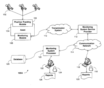
systems have been found to have limitations, for example, they can be
laborious and
time consuming. For example, system administrators are typically required to
create
(e.g., 'draw') the geographical boundaries of each work site. This activity
can be rather
slow and inefficient as there can be a delay from the time that the asset
arrives on the
work site to the time an administrator defines the work site in the M2M
application.
[0004] The following provides a system and method to address the above.
SUMMARY
[0005] In one aspect, there is provided a method of visualizing a site
having at least
one cluster of assets, the method comprising: determining a location for an
asset;
determine at least one additional asset within a particular region, based on
the location
of the asset; determine a subset of assets to be analyzed, the subset
including the
asset; performing an asset clustering of the subset to create at least one
cluster of
assets; and providing an output incorporating the at least one cluster of
assets.
[0006] In another aspect, there is provided a computer readable medium
comprising
22617350.1
CA 02865371 2014-09-26
2 =
computer executable instructions for visualizing a site having at least one
cluster of
assets, the computer readable medium comprising instructions for: determining
a
location for an asset; determine at least one additional asset within a
particular region,
based on the location of the asset; determine a subset of assets to be
analyzed, the
subset including the asset; performing an asset clustering of the subset to
create at
least one cluster of assets; and providing an output incorporating the at
least one cluster
of assets.
[0007] In yet another aspect, there is provided a system for
visualizing a site having
at least one cluster of assets, the system comprising at least one server
device
configured for: determining a location for an asset; determining at least one
additional
asset within a particular region, based on the location of the asset;
determining a subset
of assets to be analyzed, the subset including the asset; performing an asset
clustering
of the subset to create at least one cluster of assets; and providing an
output
incorporating the at least one cluster of assets.
BRIEF DESCRIPTION OF THE DRAWINGS
[0008] Embodiments will now be described by way of example only with
reference to
the appended drawings wherein:
[0009] FIG. 1A is a block diagram showing an exemplary embodiment of
a system
architecture for implementing asset information allocation and reporting
[0010] FIG. 1B is a block diagram showing another exemplary
embodiment of a
system architecture for implementing asset information allocation and
reporting
[0011] FIG. 2 is a block diagram showing exemplary components of the
position
tracking module; with on example embodiment
[0012] FIG. 3 is a block diagram showing a monitoring module, in
accordance with
an example embodiment;
[0013] FIG. 4 is a block diagram showing a monitoring system
processor, in
accordance with an example embodiment;
[0014] FIG. 5 is a block diagram showing a geospatial analysis system
architecture,
in accordance with an example embodiment;
22617350.1
CA 02865371 2014-09-26
3
[0015] FIG. 6 is a flow diagram showing a method for asset clustering, in
accordance
with an example embodiment;
[0016] FIG. 7 is a flow diagram illustrating data collection analysis and
reporting, in
accordance with an example embodiment;
[0017] FIG. 8 is a block diagram showing a plurality of reports, in
accordance with an
example embodiment;
[0018] FIG. 9 shows a clustering report, in accordance with an example
embodiment; and
[0019] FIG. 10 shows a detailed report on asset parameters aggregated into
clusters, in accordance with an example embodiment;
DETAILED DESCRIPTION
[0020] It has been recognized that a system that is configured provide an
efficient
and dynamic way to consolidate remotely connected (e.g. mobile) assets into
work site
clusters, analyze data on the clusters, and be able to do so in real-time
would be
advantageous.
[0021] The following describes a system and method to provide dynamic
consolidation of remotely connected, mobile assets into sites, done in real-
time.
Additionally, the utilization of each asset can be calculated and aggregated
into a
utilization value for the entire cluster. The cluster data (e.g., included
assets, health and
maintenance, utilization, etc.) is presented to end users through a
communication
device and its user interface.
[0022] In the following discussion, the assets contained within the sites
(clusters)
that are being monitored are typically portable pieces of construction
equipment. For
example, generators, compressors, aerial work platforms, light towers, etc.
They are
being consolidated so that interested parties can have a holistic view of the
equipment
at a work site. A cluster represents what the system believes to be a work
site. Work
sites are important to various constituents for the following reasons:
[0023] Field service technicians ¨ when dispatched to provide service they
can
better plan their work by knowing if the asset can be taken out of commission
and
22617350.1
CA 02865371 2014-09-26
4
. ,
replaced by another one on site. It also allows them to identify any other
work that they
could perform while in the vicinity.
[0024] Job Forman ¨ balance asset workload. Gives insight into how
they can
allocate assets to ensure that bottlenecks are not created by an unbalanced
utilization
of assets. Can also reduce job costs by removing unused assets from a site.
[0025] Rental Company ¨ can provide additional services to customers
by
suggesting which equipment should be taken on and off rent.
[0026] GPS position is remotely transmitted to a back office analysis
engine, as
described below, where the position is evaluated and compared to the most
recent GPS
positions of other assets, e.g. by executing a clustering algorithm. It is
this data point
that is used to evaluate the cluster.
[0027] The clustering algorithm may be done at the gateway level as
asset positions
arrive. A global collection of assets can be analyzed to find density-based
groupings of
assets and each grouping saved as a "site". As described below, the clustering
may be
performed by executing pre-filtering and scanning (e.g. DBSCAN) stages with
post
processing performed, and regions defined, thereafter.
[0028] It has also been recognized that run hour data is another data
point (like
GPS) that can be transmitted from the remote asset. For example, the number of
hours
that the asset has been running can form the "run hour data", analogous to the
odometer in a car. The run hour data can be used to determine how the asset is
utilized
on site. The real-time aspect is important, as it needs to be re-evaluated as
equipment
moves on/off of the job site. An algorithm described below uses statistical
analysis and
subsequent application in real-time based on the cluster results.
[0029] To illustrate an environment in which the above-noted
clustering and geo-
spatial analyses may be conducted and utilized, FIGS. 1-4 are now described.
[0030] FIG. 1A illustrates an example environment 100A, within which
asset
information reporting can be implemented. The example environment 100A
comprises
an asset 104, which can, in turn, include an installed position tracking
module 106 and a
monitoring module 108. The position tracking module can integrate a GPS
transceiver
22617350.1
CA 02865371 2014-09-26
. ,
to communicate with GPS satellites 102. The monitoring module 108 collects,
stores,
receives, (and possibly processes) and transmits various information related
to the
positional and operational data of the asset 104. The monitoring module 108
can
communicate with the position tracking module 106 in order to monitor the
position of
the asset 104. The monitoring module 108 can also integrate a
cellular/satellite
transceiver, local wireless technology, and/or various computing technologies
into a
single mobile positioning and communication system. The monitoring module 108
can
also include a GPS transceiver on its own, in another exemplary embodiment.
The
monitoring module 108 can send position coordinates, such as GPS data
coordinates
and sensor events, and messages from the asset 104 to monitoring system
service
provider 112 running software specifically designed to process this type of
information.
The monitoring module 108 processes information and make decisions on
intelligent
reporting of data that is to be collected and reported. The monitoring module
108 can
also receive messages sent from the monitoring system service provider 112.
[0031] The environment 100A can include a transmission system 110.
This
transmission system can be utilized for transmitting and receiving positional
and
operational data to and from the monitoring module 108. The transmission
system 110
in this example includes a satellite network and/or a cellular network. The
transmission
system 110 can also be a short range wireless network used by computer
systems.
Transmission system 110 can also receive and transmit the positional and
operational
data from a monitoring system service provider 112. The monitoring system
service
provider 112 may include dedicated circuitry or a general purpose computer
configurable to make the information collected at the monitoring module 108
available
through an open architecture interface, such as an Application Programming
Interface
(API). The environment 100 can also include a communications network 114. The
network 114 can be a network of data processing nodes that are interconnected
for the
purpose of data communication (e.g., a global computer network, such as the
Internet).
[0032] The monitoring system provider 112 is communicatively coupled
to the
network 114. A monitoring system processor 120, illustrated within the
environment
100, can also be communicatively coupled to the network 114. The monitoring
system
processor 120 can be utilized to access and pull the positional and
operational data
22617350.1
CA 02865371 2014-09-26
6
associated with the asset 104 via the open architecture interface. Various
communication protocols (e.g., Web Services) can be utilized in the
communications
occurring between the monitoring system processor 120 and the monitoring
system
service provider 112. The monitoring system service provider 112 can utilize
telematics
and intelligent data processing as well as software to make the information
available via
the network 114.
[0033] While illustrated as two separated systems, in an example, the
monitoring
module 108 and the monitoring system processor 120 can be integrated and
communication between the two systems occur as an asset that is being
monitored.
[0034] The monitoring system processor 120 can be communicatively coupled
to a
database 125, in which the monitoring system processor 120 may periodically
store
results after processing of the information received from the monitoring
system provider
112. The monitoring system processor 120 can includes various modules,
discussed in
more detail below with reference to FIG. 3. The modules of the monitoring
system
processor 120 can be utilized to perform various operations discussed in more
detail
with reference to FIGS. 6 and 7.
[0035] The monitoring system processor 120 is optionally associated with an
operator 124 operating the monitoring system processor 120 via a computer 122.
The
computer 122 can include a Graphical User Interface (GUI) facilitating display
and
manipulation of the monitoring system processor 120. The computer 122 can also
enable the operator 124 to view and manipulate reports 126 that can be used to
manage and monitor one or more of the assets associated with the authorized
user.
The monitor can be remote and the graphics being displayed can be over a
computer
network. A computer 122 is shown as an exemplary device for operating the
monitoring
system processor 120 in this particular embodiment; however, it can be
appreciated that
any device that can communicate instructions with a monitoring system
processor 120
can be utilized in place of a computer 122. Devices such as a tablet computer,
mobile
phone, personal digital assistant, and/or laptops can be used for this
purpose. The
monitoring system processor 120 can also be housed on a cloud and accessed by
any
device that can act as a terminal with access to the cloud.
22617350.1
CA 02865371 2014-09-26
7
[0036] The authorized user can receive real-time reports related to the
asset usage,
performance, and location. Using detailed map views, the authorized user can
see up-
to-date data related to location of the asset 104. The reports 124 can include
a
production report. The production report, for example, can detail number of
loads, cycle
times, and amount of material moved by the asset 104. The reports 126 can
include a
utilization report. The utilization report, for example, can detail fuel
efficiency, idle and
working time of the asset 104. The reports 126 can also include a maintenance
report.
The maintenance report can include a record of the asset 104 maintenance
history. The
reports 126 can also include a health report. The health report can include
the current
health of the asset 104 by analyzing faults and alarms. These reports 126 can
provide
the data on a collection of individual assets 104 by combining them into
clusters based
upon their location, as discussed in relation to FIG. 5.
[0037] The monitoring system processor 120 can provide the reports 126 to
an
authorized user 118 via the communication network 114. The authorized user 118
can
view the reports 126 using a general purpose computer 116 or any other device
providing an ability to view the reports 126. In some example embodiments, the
monitoring system processor 120 can send copies of the reports 126 to the
authorized
user 118 attached or embedded in a body of an electronic email. The reports
126 are
based on the information initially provided by the monitoring module 108. The
monitoring module 108 is described below, by way of example with reference to
FIG. 2.
[0038] FIG. 1B is illustrates an example system 100B, within which asset
information reporting can be implemented in a manner similar to that described
herein
with reference to FIG. 1A. However, environment 100B includes a further asset
user
device 128 that can sense and provide data associated with the asset 104, e.g.
an
embedded computer, coupled electronic device, integrated sensor, etc.. The
device 128
can provide the data to a network 132, which in turn can communicate the data
to at
least one of a transmission system 110, the monitoring system service provider
112,
directly to a user computer 116, monitoring system processor 120 or the
further
communication network 114. In a further example, the device 128 stores data in
its
memory and then downloads the data when connected to a user device, e.g., when
plugged into a user computer for synchronization or battery charging.
22617350.1
CA 02865371 2014-09-26
8
. .
[0039] System 100B includes an asset device 128 that can provide
additional data
regarding the asset 104. Asset device 128 can be a mobile device that is
physically
separate from the asset 104 but can provide additional data regarding the
asset. Asset
device 128 can include its own position tracking module 130. For example, the
asset
device 128 can be the mobile phone of the asset operator. In this case the
mobile-
phone, asset device 128 can determine the location of the device 128 and
report it
through network 132, which can also include one of more of the communication
network
114, the transmission system 110 in any of its embodiments, to at least one of
the
monitoring system service provider 112, the authorized user 118 through the
general
purpose computer 116 and the monitoring system processor 120. The additional
data
from the asset device 128 can be used to supplement the data used in
processing the
received data to produce reports.
[0040] The data collection device 128 can be an asset user electronic
device that
includes a processor and memory. The device 128 can sense or input data
relating to
the asset 128 for reporting performance and status of the asset. In an
example, the
device 128 includes a navigational positioning system that tracks the position
of the
device 128. During certain known times, the device 128 is closely associated
with the
asset as the operator/user is controlling the asset. The device 128 can then
report
positional data that can be used to evaluate the performance of the asset. The
device
128 can run a program that stores its location at certain times. The time of
the location
data will also be stored to correlate the location data with operational data
from the
asset 104.
[0041] The device 128 can further execute instructions that provide a
template or
structured input box to prompt the user to input desired information that can
be used to
evaluate asset performance. In an example, certain predicted events can be
part of the
template. Examples of predicted events can be lunch breaks, arrival at a known
location, loading event, unloading event, maintenance event, etc. Any data
type can be
input into the reporting system by the device 128.
[0042] The device 128 can further input data for reporting in an
unstructured format.
Any event or other data that a user believes to be important to the
performance can be
22617350.1
CA 02865371 2014-09-26
9
input from the device into the report system. The device 128 can communicate
with
other components of the reporting system using other electronic
communications, e.g.,
email, text message, voice mail, etc. The additional data provided by the
device 128 can
be used to for maintenance tracking, asset mechanical status, asset electrical
status, or
other performance. The additional data can further document fluid checks or
odometer
readings. The additional data can also include images of the asset, for
example, after
an accident or mishap, or routine documentation of the asset according to
contractual
agreements, e.g., insurance agreement or rental agreement. The third party
agreements can be implemented in an application, (i.e., stored and executable
instructions), that requests the required data to be input by the user through
the device
128.
[0043] In a further example, the device 128 can provide data relating to
the asset to
the user. The data provided to the device 128 can be parts lists, maintenance
data,
operating instructions, links to acquire reports, data, or templates, or other
data. This
data can be provided by the monitoring system provider 112 or the monitoring
system
processor 120 or from third parties through these environment components and
communication networks.
[0044] The monitoring system provider 112 or processor 120 can filter
and/or
process the data into reports that can be provided to an end user or owner of
the
assets. The reports can be populated with data from the device 128 to provide
a more
robust report and automate asset reporting, maintenance, and other efficient
reporting.
[0045] Data communication as described in FIGS. 1A and 1B couples the
various
devices together. The network 114 is preferably the Internet, but can be any
network
capable of communicating data between devices can be used with the present
system.
In addition to the Internet, suitable networks can also include or interface
with any one
or more of, for instance, an local intranet, a PAN (Personal Area Network), a
LAN (Local
Area Network), a WAN (Wide Area Network), a MAN (Metropolitan Area Network), a
virtual private network (VPN), a storage area network (SAN), a frame relay
connection,
an Advanced Intelligent Network (AIN) connection, a synchronous optical
network
(SONET) connection, a digital Ti, T3, El or E3 line, Digital Data Service
(DDS)
22617350.1
CA 02865371 2014-09-26
connection, DSL (Digital Subscriber Line) connection, an Ethernet connection,
an ISDN
(Integrated Services Digital Network) line, a dial-up port such as a V.90,
V.34 or V.34bis
analog modem connection, a cable modem, an ATM (Asynchronous Transfer Mode)
connection, or an FDDI (Fiber Distributed Data Interface) or CDDI (Copper
Distributed
Data Interface) connection. Furthermore, communications can also include links
to any
of a variety of wireless networks, including WAP (Wireless Application
Protocol), GPRS
(General Packet Radio Service), GSM (Global System for Mobile Communication),
CDMA (Code Division Multiple Access) or TDMA (Time Division Multiple Access),
cellular phone networks, GPS (Global Positioning System), CDPD (cellular
digital
packet data), RIM (Research in Motion, Limited) duplex paging network,
Bluetooth
radio, or an IEEE 802.11-based radio frequency network. The communication
network
114 can further include or interface with any one or more of an RS-232 serial
connection, an IEEE-1394 (Firewire) connection, a Fiber Channel connection, an
IrDA
(infrared) port, a SCSI (Small Computer Systems Interface) connection, a USB
(Universal Serial Bus) connection or other wired or wireless, digital or
analog interface
or connection, mesh or Digie networking. In an example, the network 132 can be
capable of communicating using any one or a plurality of the above
communication
means discussed herein.
[0046] FIG. 2 is a block diagram showing the exemplary subcomponents of a
position tracking module 106. The position tracking module 106 comprises a GPS
antenna 202 which can interface with a built-in GPS component 204. The GPS
component 204 transmits and receives location data through the GPS antenna 202
in
order to communicate with GPS satellites. This communication is used to
determine the
location of the position tracking module 106. A CPU 206 processes the data
from the
GPS 204 and allows interfacing between the various subcomponents of the
position
tracking module 106. A GSM/GPRS modem 210 allows for communication with
cellular
networks to transmit and receive data (including but not limited to positional
data)
across the GSM and GPRS antenna 208. The GSM/GPRS modem 210 is connected to
the CPU 206 for further processing of data.
[0047] The CPU 206 has connections to digital inputs 212 for interfacing
with any
digital device or a digital signal inputted into the position tracking module
106.
22617350.1
CA 02865371 2014-09-26
11
Exemplary digital inputs can come from switch closures, relay contacts, or
transistor¨
transistor logic interface signals. Similarly, a digital output 214 can send
digital signals
from the position tracking module 106. These digital signals can be received
by any
device or group of devices capable of receiving digital signals. An analog
input 216
allows for the input analog of signals. Exemplary analog signals can include
signals
from transducers that can sense pressure and temperature. The signals inputted
as
analog can be converted to digital or vice versa, in order to make processing
by the
CPU 206 more efficient as desired. A motion sensor 218 is also present in the
position
tracking module. The motion sensor 218 can be used to ensure the tracking
module 106
is safe and to sense any unexpected behavior in terms of motion for the
position
tracking module 106. Memory components 220 can be used to store any data
received
from the inputs or being processed by the CPU 206. Exemplary memory components
include RAM, ROM, and/or flash storage. A battery 222 is used to power the
position
tracking module. The status of the battery 222 health and charge level can be
monitored
by the CPU 206. The battery can be either chargeable or rechargeable, with
exemplary
battery types comprising of Li-Ion, Alkaline, Ni-Li, NiMH, and NiCd among
others. A
display 224 can be used to interface with a user or viewer. The display 224
can include
LED lights to indicate functionality and errors, or a screen such as LCD to
display
information regarding the position tracking module 106 and its subcomponents.
[0048] FIG. 3 is a block diagram showing a monitoring module 108, in
accordance
with an example embodiment. The monitoring module 108 can includes a wiring
harness 302, an antenna 304, a transmitter 308, a receiver 312 an enclosure
306, an
isolation relay 316, an adjustable relay 310, a monitoring device 320,
sensor(s) 314,
and processor(s) 318. The monitoring module 108 can be a stand-alone component
utilized to determine and communicate asset status, which can include
position, speed,
and direction. The monitoring module 108 can also interface with the sensors
314 and
external accessories as part of an on-board system that monitors asset's
performance.
Events being monitored include an ignition status, a distance moved since last
valid
loading or unloading event, a time elapsed since last valid loading or
unloading event, a
loading sensor "on" time and "off" time, an unloading sensor "on" time and
"off" time.
[0049] The transmitter 308 and the receiver 312 are electrically connected
to the
22617350.1
CA 02865371 2014-09-26
12
. .
antenna 304 for respectively sends in receiving over the air electromagnetic
signals.
The transmitter 308 includes electronic circuits to receive an input signal
from the
antenna 304. The transmitter 308 can include a power supply, an oscillator, a
modulator, and amplifiers for specific frequencies. The modulator adds signal
information onto a carrier frequency, which is then broadcast from the antenna
304. The
receiver 312 can include electronic filters to separate a desired radio signal
from noise
and other signals sensed by the antenna 304. The receiver 312 amplifies the
desired
signal to a level suitable for further electronic processing, e.g.,
demodulation and
decoding, and signal processing. While the transmitter 308 and the receiver
312 are
shown as separate devices in FIG. 3, it will be recognized that a transceiver,
a device
that includes circuits for both sending and receiving is within the scope of
the present
disclosure.
[0050] The monitoring device 320 can include firmware, which supports
automated
monitoring, and reporting of the asset 104 activities and status. For example,
the
monitoring device 320 can detect an alert and cause the antenna 304 to send
the alert
to the monitoring system provider 112. The alert sent to the monitoring system
provider
112 can be, in an example, accompanied by a location and operational data of
the asset
104. Information related to other events can be detected, stored, and
transmitted by the
monitoring device 320. The monitoring device 320 can automatically report
arrival or
departure of the asset 104 from a job or home site location. The monitoring
device 320
can also record and transmit various machine utilization parameters, such as a
time and
distance traveled. The monitoring device 320 can be mounted on the asset 104
and
does not require operator access or involvement.
[0051] The monitoring device 320 can include processors that execute
applications,
which are instructions stored on computer readable media. The local processing
capability of the monitoring can perform simple and complex logic, including
but not
limited to, power management, communication management, data storage,
encrypted
communication, and/or real time clock processing and management.
[0052] The wiring harness 302 includes, in an example, a string of
cables and/or
wires, which transmit electrical signals or operating currents between other
components
22617350.1
CA 02865371 2014-09-26
13
. .
of the monitoring module 108. By binding wires and cables into a cable
harness, the
wires and cables are secured against the adverse effects of vibrations,
abrasions, and
moisture. By constricting the wires into a non-flexing bundle, usage of space
is
optimized and the risk of a short circuit is decreased. The wires bundled in
the wiring
harness 302 can be connected to various parts of the asset 104 to transmit
various
signals from sensors 314, activators (not shown), pumps (not shown), or other
asset
components to the monitoring module 108.
[0053] The sensor(s) 314 can be installed at various locations of the
asset 104. The
sensors 314 can measure loading and unloading operations associated with the
assets
such as excavators, haul trucks, loaders. To communicate the event to the
monitoring
device 320, the sensors 314 can also utilize short range radio communications
protocol
(e.g., IEEE 802.15.X, IEEE 802.15.4, or other short range wireless
technologies). A
sensor 314 can be a fuel air mixture sensor. A sensor 314 can monitor motor
exhaust
for various components of the exhaust gas. A sensor 314 can detect oil quality
or oil
pressure or time since last oil change. A sensor 314 can measure engine speed
(rpm)
or hours of operation. A sensor 314 can measure fuel level. Other fault
detection can be
sensed by sensor 314.
[0054] For example, in a scraper the wires can be utilized to
transmit electrical
signals when the apron opens and/or closes and ejector door extends and/or
retracts.
The wires can also be utilized to transmit signal back to the monitoring
device 320
when, for example, the operator of the asset 104 engages various controls.
Thus, the
components of the monitoring module 108 can be combined to enable the
transmission
of GPS position data, events, alarms, and sensor inputs to the monitoring
system
provider 112 via a satellite and/or cellular network. Data can be stored by
the monitoring
module 108 for a period of time until a transmission can be made.
[0055] The sensor 314 can also be used to determine utilization of
the asset. The
sensor 314 can sense the movement of part of the asset. In an example, the
part is
different that the prime mover, e.g., a motor. The part can be a lift
mechanism, an arm
or other part that is not in a certain determinable position when the asset is
in use. In an
example, the sensor 314 can be a contact sensor that determines if part of the
asset is
22617350.1
CA 02865371 2014-09-26
14
not in a home or rest, i.e., non-utilization position. In a further example,
the sensor
senses when a person is on the asset, controlling the asset or at a specific
location. The
sensor 314 can be switch that must be activated by the user for the asset to
work.
When activated, the sensor 314 senses a utilization event.
[0056] The isolation relay 316 and the adjustable relay 310 can be utilized
to
regulate the information transmitted and received from the monitoring device
320. In
some example embodiments, only the adjustable relay 310 is needed to provide a
signal-to-ground contact closure while monitoring the transmission between the
monitoring module 108 and the monitoring system provider 112.
[0057] The isolation relay 316 can allow a determination to be made as to
whether
the asset 104 is operational. All of the example components of the monitoring
module
108 can be provided inside the enclosure 306. The enclosure 306 is, in an
example, a
metal housing that is sealed against dirt, grime, dust, and moisture that are
generated at
building construction sites, road construction sites, and in agriculture. It
will be noted
that the monitoring module 108 is not bound to a particular monitoring system
provider.
Any hardware that can successfully interface with the monitoring module 108
can be
utilized as the monitoring system provider 112. The monitoring module 108 can,
in
some example embodiments, be specifically designed for the asset 104.
[0058] The processor(s) 318 operate to control various operations of the
asset. In an
example, the processor 318 is an electronic device to process received signals
and
output control signals to control operation of a component of the asset. An
example of a
processor 318 is an engine controller. Processors 318 can be microcontrollers
and/or
electronic control units (ECUs). Electronic control units can be made from
programmable logic controllers and/or programmable gate arrays. In an example,
a
main processor 318 is provided and it controls other processors in a
master/slave
configurations. Processor(s) 318 can further operate without a master
processor. In
operation, the processor 318 receives a sensed signal from a sensor 314
regarding the
operation of the asset. The processor 318 applies stored instructions to the
sensed data
and outputs a control signal to a component of the asset or stores the
operational data
in a memory.
22617350.1
CA 02865371 2014-09-26
. .
[0059] A bus 320 provides a data communication path between the
devices 302-318.
In an example, bus 320 is a serial bus, e.g., Modbus or ethernet. The bus 320
can also
be a controller area network, e.g., CAN-bus, CAN-open, SAE J1939 CAN-bus. A
controller area network is a multi-master broadcast serial bus standard for
connecting
electronic control units (ECUs), such as a processor 318, to other electronic
devices.
[0060] FIG. 4 is a block diagram showing a monitoring system
processor 120, in
accordance with an example embodiment. The monitoring system processor 120 can
include, in some example embodiments, a data communication module 402, a data
interpreting module 404, an analysis performing module 406, a report generator
module
408, and the database 410. The operations of the modules and the monitoring
system
processor 120 are explained in more detail within the context of example
methods for
asset information reporting illustrated in FIGS. 7 and 8.
[0061] FIG. 5 is a block diagram showing the system architecture for
analysis of
asset location data to form a geospatial analysis. Assets 500A, 500B, and
500C, are
present at their respective work site locations. The position of these assets
is
communicated through a gateway 502 to a real time engine 504. The gateway 502
can
be any exemplary network set-up used to communicate data, for instance those
shown
in FIG. 1, such as network 132 or communication network 114 in the example
embodiments provided. The real-time engine 504 can include any device or
system
capable of processing the data associated with the asset 104 in real-time.
Example
embodiments include those discussed as monitoring system processors 120 or an
authorized computer 116. The real-time engine 504 can be stored on a local
machine or
operated through access to a cloud network. The real-time engine 504 has
capabilities
for asset data analysis 506, in particular analysis for data clustering,
statistical analysis,
and data aggregation. This analysis can be done locally at the real time
engine 504, or
by the ability for the real time engine 504 to interface with a cloud or other
machine.
While the examples described herein illustrate "real-time" operations, the
principles can
also be applied to non-real-time or near-real-time configurations.
[0062] Web mapping and imagery services 508 are used to create
visualizations of
work sites 510. Web mapping and imagery services 508 can include services such
as
22617350.1
CA 02865371 2014-09-26
16
Bing imagery services, Google maps services, or other mapping services
available. The
work sites 510 represent geographic locations. These locations can be
determined by
globally administrative areas, officially recognized geo-political regions, or
custom
regions defined for the purpose of the desired geospatial analysis. The work
sites 510
can also be determined based on an ownership hierarchy to determine company or
group administered locations. The instructions from the real-time engine and
information
regarding work sites can be housed in a message queue 512. The message queue
512
stores control messages or content until they are received by the receiving
device. The
message queue 512 can achieve this in the monitoring system processor 120 or
even
within the communication network 114 as shown in FIG. 1. In this particular
embodiment, the receiving device is a database 126. The receiving device can
also be
a computer 116 or 122 as shown in FIG. 1.
[0063] FIG. 6 is a flowchart illustrating a process of clustering machines
into work
sites based on one example embodiment. The asset's positional data is
determined at
operation 600 using, for example, a GPS receiver. This can be done using the
position
tracking module 106, shown in FIG. 1. Using the data, the GPS region of the
asset is
confirmed. As discussed in relation to FIG. 5, regions include those defined
as global
administrative areas in this embodiment. When the region of the asset 104 (as
shown
in FIG. 1) is confirmed, all other assets present in the region are also
determined at
operation 604. This creates a set of assets present in the region. The assets
are
crawled for ownership at step 606 to determine which company or group the
asset
belongs to. At operation 608 all the information is compiled for analysis,
exemplary
information includes information on an asset's region, the set of assets in
the region of
the asset under consideration, and ownership information regarding the asset.
This data
is then processed using a clustering algorithm such as DBSCAN to form
clusters/work
sites at operation 610.
[0064] One example of a clustering algorithm that may be used will now be
described. The clustering analysis may be done at the gateway level as asset
positions
arrive. A global collection of assets can be analyzed to find density-based
groupings of
assets, and each grouping may be saved as a "site". An example of such
processing is
below.
22617350.1
CA 02865371 2014-09-26
17
[0065] Stage 1: Pre-filtering:
[0066] The first stage of processing is to compute the subset of assets
(out of the
entire global collection of assets) that are affected by the asset currently
being
processed. 1) An asset's GPS coordinate is used to lookup its region
(described below,
see "Regions (Geo-political)"). 2) The set of assets currently also residing
within that
region are determined (e.g., by performing a look up) and a hierarchy is
traversed by
visiting each company and group once, in breadth-first traversal. At each
iteration, the
set of assets found as direct "children" of the company/group are intersected
with the
set retrieved in 2), and at this point the subset of assets to analyze is
obtained. It may
be noted that after Stage 2 (described below) is complete, the next iteration
of Stage 1
begins.
[0067] Stage 2: DBSCAN:
[0068] A core clustering algorithm that may be used is DBSCAN. There are
two
kinds of points in a cluster, points inside of the cluster (core points) and
points on the
border of the cluster (border points). To find a cluster, DBSCAN starts with
an arbitrary
point p from the dataset and retrieves all points density-reachable from p
with respect to
an epsilon (Eps) and MinPts value. If p is a core point, this procedure yields
a cluster. If
p is a border point, no points are density-reachable from p and DBSCAN visits
the next
point of the dataset,
[0069] Ths following pseudo code illustrates an example DBSCAN:
[0070] DBSCAN (Set0fPoints, Eps, MinPts)
[0071] II SetOf Points is UNCLASSIFIED
[0072] ClusterId := nextld(NOISE);
[0073] FOR Point in Set0fPoints DO
[0074] IF Point.Clusterld equals UNCLASSIFIED THEN
[0075] IF ExpandCluster(Set0fPoints, Point, ClusterId, Eps,
MinPts) THEN
[0076] ClusterId := nextld(Clusterld)
22617350.1
CA 02865371 2014-09-26
18
. .
[0077] END IF
[0078] END IF
[0079] END FOR
[0080] END; // DBSCAN
[0081] ExpandCluster
[0082] The ExpandCluster function is an important step in the DBSCAN
algorithm. It
functions to expand from a single point to find further core points, and
assigns each
point a cluster identifier to distinguish it from a border point as follows:
[0083] ExpandCluster(Set0fPoints, Point, ClusterId, Eps, MinPts) :
Boolean;
[0084] seeds := GetNeighbors(Set0fPoints, Point, Eps);
[0085] IF seeds.size < MinPts THEN // no core point
[0086] Point.Clusterld := NOISE;
[0087] RETURN False;
[0088] ELSE // all points in seeds are density-reachable from
Point
[0089] setCluserlds(seeds, ClusterId); // iterates seed
[0090] seeds.delete(Point);
[0091]
[0092] WHILE seeds <> Empty DO
[0093] currentP := seeds.first();
[0094] result := GetNeighbors(Set0fPoints, currentP,
Eps);
[0095] IF result.size >= MinPts THEN
[0096] FOR resultP in result DO
[0097] IF resultP.Clusterld IN
{UNCLASSIFIED,
NOISE} THEN
[0098]
IF resultP.Clusterld = UNCLASSIFIED
22617350.1
CA 02865371 2014-09-26
19
. .
THEN
[0099] seeds.append(resultP);
[00100] END IF;
[00101] resultP.Clusterld := ClusterId;
[00102] END IF; // UNCLASSIFIED or NOISE
[00103] END FOR;
[00104] END IF; // result.size >= MinPts
[00105] seeds.delete(currentP);
[00106] END WHILE; // seeds <> Empty
[00107] RETURN True;
[00108] END IF
[00109] END; // ExpandCluster
[00110] Set0fPoints is the subset assets from the iteration in stage 1. Eps is
the
maximum distance in meters allowed to consider an asset a "neighbour" of
another
asset. It is determined based on the following heuristic:
[00111] IF Set0fPoints.size >= 200 THEN Eps := 1250 // 1,250 meters
[00112] IF Set0fPoints.size >= 400 THEN Eps := 1500
[00113] ELSE Eps := 1000
[00114] This accounts for large to very large fleets spanning greater
distances geo-
spatially. MinPts is always 3 (IE we will never consider a cluster of 2 or
less).
[00115] GetNeighbors:
[00116] The GetNeighbors function returns the set points in Set0fPoints that
are the
"Eps-Neighbors" of Point.
[00117] Specifically, if the spherical distance in meters between Point and a
point P' in
Set0fPoints is less than or equal to Eps, P' is included in the returned set.
22617350.1
CA 02865371 2014-09-26
[00118] Post-processing:
[00119] 1) After the density-based sets of assets are determined, each set is
saved as
a "Job Site" object with the following additional attributes:
[00120] Geo-political region used in the iteration; and
[00121] Hierarchy location (company or group) used in the iteration.
[00122] The Site is considered "new" if there is no other site in the region
with a
matching attribute for 2), and the same set of assets. New sites are saved to
storage.
[00123] 2) Each saved Site is given a centroid coordinate via a simple
"containing
rectangle" center point determination. This center point is passed to a 3rd
post-
processing unit for further augmentation of the Site object (NodeJS):
[00124] - satellite imagery is looked up for the coordinate. For example, the
BING
Maps Imagery service can be used for this purpose.
[00125] - the coordinate is reverse geocoded to a likely "place name" using
the
Google Places API.
[00126] Regions (Geo-political):
[00127] A database of geo-political world "regions" can be derived from the
datum
files at "http://www.gadm.org" and customized specifically for the processing
described
in "Stage 1: Pre-filtering". The datum files contains 379 "global
administrative areas"
(GADM) with their geo-spatial shape:
[00128] With the exception of Australia, Canada, Mexico, Netherlands, and the
United
States, all countries/territories as defined in "GADM Level 0" are included.
This
accounts for 258 regions of the total dataset. Australia, Canada, Mexico,
Netherlands
and the United States as defined by their subdivisions in "GADM Level 1" are
included.
This accounts for 121 regions of the total dataset.
[00129] FIG. 7 is a process flow diagram illustrating a method for asset
information in
accordance with an example embodiment. The method can be performed by
processing
logic that can comprise hardware (e.g., dedicated logic, programmable logic,
microcode,
etc.), software (such as software run on a general purpose computer system or
a
22617350.1
CA 02865371 2014-09-26
21
dedicated machine), or a combination of both. In one example embodiment, the
processing logic resides at the monitoring system processor 120, illustrated
in FIG. 4.
The method process depicted in FIG. 7 can be performed by the various modules
discussed above with reference to FIG. 4. Each of these modules can comprise
processing logic.
[00130] As shown in FIG. 7, the process commences at operation 700 with the
data
communication module 402 receiving data related to the operation of the asset
104. The
data received by the communication module 402 can include the positional and
operational data associated with the asset 104. The positional data can be
obtained
using the position navigation system, e.g., Global Positioning System (GPS),
or a
cellular triangulation system by the position tracking module 106 installed on
the asset
104 and transmitted to the monitoring system provider 112. The positional and
the
operational data can be made available over a network from the monitoring
system
service provider 112 using an appropriate protocol (e.g., Web Services).
[00131] Examples of operational data include, but are not limited to,
velocity,
direction, an ignition key ON event, an ignition key OFF event, a door open
event, a
door closed event, a location, a fuel efficiency (e.g., fuel burn
calculation), an idle time,
a production statistics, a preventive maintenance schedule, a maintenance
history, a
cycle time, a utilization time period, a fault data, and an alarm data. The
positional and
the operational data can be received via a transmission system 110 at the
monitoring
system service provider 112 and then pulled by the monitoring system processor
120.
[00132] In some examples described above information may not be able to be
transmitted immediately from the monitoring module 108 to the monitoring
system
service provider 112 due to, for example, a temporary unavailability of a
satellite and/or
the cellular network which comprises the transmission system 110. The
monitoring
module 108 can store information until communication over one of the networks
between the monitoring module 108 and the monitoring system service provider
112 is
restored. If the communication is disrupted due to the asset 104 moving out of
the
coverage area, the monitoring module 108 can be removed from the asset 104 and
brought back into the coverage area. Alternatively, the asset 104 can be moved
into the
22617350.1
CA 02865371 2014-09-26
22
. .
coverage area. Once the communications are restored, the monitoring module 108
can
transmit information to the monitoring system service provider 112.
[00133] At operation 704, the data interpreting module 404 of the monitoring
system
processor 120 can interpret the positional data in view of the operational
data to
accurately determine characteristics of the asset 104. At operation 706, the
data
interpreting module 404 of the monitoring system processor 120 can perform
analysis of
the operational characteristic in view of a stored target to produce a
performance
output.
[00134] The stored target can be related to the asset 104 and/or to a site'
specific data
related. In some example embodiments, a relationship between the performance
output
and the site specific data can be included in the reports 126.
[00135] The data interpreting module 404 of the monitoring system processor
120 can
intelligently interpret the positional data of the asset 104 in view of the
operational data.
Any event having a low probability of occurring in view of the positional data
associated
with the asset 104 or in view of one or more of other events occurring in the
same or
nearly the same time, can be eliminated as false. For example, the data
analyzing
module 406 can determine that at the time of the reported loading event, the
asset 104
was not operational or operational for a period of time which is too short for
the loading
to occur.
[00136] Thus, the reported loading event can be eliminate as false, if the
data related
to the ignition status shows that the asset was still in the warm-up phase. In
another
example embodiment, the data analyzing module 406 can compare the performance
data of the asset to the positional data to determine whether, at the time of
the reported
events, the asset was present at the respective job site. If the asset was not
present at
the respective job site, the reported event can be eliminated as false. In
some example
embodiments, the data analyzing module 406 can analyze the performance data to
ensure that each loading event is followed by an unloading event and vice
versa.
[00137] In some example embodiments, invalid loading events can also be
eliminated
when a determination is made by the data analyzing module 406 comparing the
performance data of the asset to the positional data, that asset has not moved
between
22617350.1
CA 02865371 2014-09-26
23
. .
two events. Furthermore, invalid loading events can also be eliminated when
the
analyzing module 406 determines that the time period elapsed between the
consecutive
loading events is less than a predetermined time period.
[00138] It will be understood that various filter values can be
associated with particular
events and particular type and location of the asset. The filters can be
adjusted by a
user per each different asset. It will be further understood, that operators
of the
monitoring system processor 120 or a customer can be provided with an ability
to set
other criteria to intelligently analyze performance data of the asset 104. The
information
can be processed and sent for interpretations and analysis in near real-time.
[00139] At operation 706, a report generating module 408 of the monitoring
system
processor 120 can provide a report that includes the operational
characteristic and the
performance output, along with data regarding the work sites and clusters for
assets. In
some example embodiments, the report can be accessed by an authorized user via
a
computer interface. In some other example embodiments a digital copy of the
report can
be sent to a predetermined user via an electronic message (e.g., email, text
message,
etc.). The report can summarize the performance output of the asset 104 or be
related
to a specific area of operational characteristics. For example, the report can
be related
to production data associated with the asset 104.
[00140] At operation 708 the reports are sent to communications devices in
order to
be viewed and analyzed by users. The report related to the production data can
include,
but is not limited to, cycle times, number of loads, an amount of material
moved, time of
operation, and costs associated with the asset 104. The report can be related
to
utilization data associated with the asset. The report related to the
utilization data can
include an idle time, an amount of fuel consumed and an amount of fuel
remaining in
the asset. The report can be related to maintenance data associated with the
asset. The
report related to the maintenance data can include a date of an upcoming
service, a
type of the upcoming service, a location of the asset, and a part associated
with the
upcoming service. The report can also be related to health data associated
with the
asset. The report related to the health data associated with the asset can
include an
alarm and a fault associated with the asset 104.
22617350.1
CA 02865371 2014-09-26
24
[00141] Databases, stored at either at the operator's computer 126 or the
authorized
user's computer 116, as well as the monitoring system database 125 can store
the
reports generated according to the methods and systems described herein. The
databases are stored on tangible computer readable media, such are magnetic
media,
electronic storage devices, optical storage devices, etc.
[00142] FIG. 8 is a block diagram showing a plurality of reports that can be
generated
for the asset 104 and/or the asset user device 128. These reports can include
a
management report 802, a production report 804, a utilization report 806, a
maintenance report 808, a health report 810, and a location report 812. The
management report 802 can represent a high-level overview of information for
each site
associated with one or more of the respective asset 104. The management report
802
can summarize the information available in one or more of other report types,
such as
the production report 804, the utilization report 806, the maintenance report
806, the
health report 810, and/or the location report 812. In some example embodiments
the
management report 802 can combine essential data from the above-mentioned
reports
and provides it in an overview format.
[00143] The production report 804 can include cycle times, number of loads per
day,
amount of the material moved each day, machine hours, and machine costs. An
aggregated site view of the data can also be generated. For example, the
production
report 804 could identify sites (vs. assets) that have over/under utilized
assets.
[00144] The utilization report 808 can include the last time the machine was
used,
how frequently the machine is used and if possible to track the user, the
frequency at
which operator is operating the machine. The maintenance report 810 can
include
machine hours, timing of scheduled services, types of scheduled services,
location of
the asset, details of the scheduled services (e.g., maintenance operations,
parts
required, etc.). The health report 810 can include machine performance
indicators,
information on any alarms that have been triggered, or any other issues with
the asset
104. The location report 812 can include information on the clustering data
regarding
the machine. It can aggregate the data regarding the location of an asset 104
and
provide information regarding other assets in its work site, as determined by
its location.
22617350.1
CA 02865371 2014-09-26
. .
[00145] FIG. 9 shows an exemplary user interface screen 902 in one embodiment,
on
a tablet computer device 900. Information regarding work sites and clusters is
displayed. A user is able to view the number of work sites present at 904.
Each work
site region is displayed with the name 906 of the work site. An aerial image
of the work
site 908 is present to show what a portion or entire work site looks like.
This image can
be acquired by a third party database or can be stored on the device 900. A
numeric
representation 910 of the number of machines present in the work site is
available. In
one exemplary embodiment, the portion of machines in their respective states
can be
displayed using a pie chart graphic 912. The graphic 912 can update in real
time to
represent the most accurate status of the machines. Machines in states that
require
high alert can be shown in the red portion of the pie while those who might
require
attention soon can be shown in yellow, those not requiring any immediate
attention can
be shown in green; in one exemplary embodiment. These alerts can represent
machines that require servicing, are being over and/or under-utilized; or any
other alerts
as configured.
[00146] FIG. 10 shows a more detailed user interface on the device 900. The
detailed
interface screen can display the name of the work site at 1002. The user can
select
from the different reports available at the device by selecting whichever one
is
necessary at 1004. These reports can include but are not limited those
described in
FIG. 8. A graphic showing the portion of machines in each state of alert is
also present
at 1006. The user can get details regarding the states of each machine in a
list 1008.
The map also shows the physical location of each machine, depicted as a point
of
interest on 1010 on the map. The indicator can be a balloon as seen in this
exemplary
embodiment or another indicator as configured.
[00147] It will be appreciated that any module or component exemplified herein
that
executes instructions may include or otherwise have access to computer
readable
media such as storage media, computer storage media, or data storage devices
(removable and/or non-removable) such as, for example, magnetic disks, optical
disks,
or tape. Computer storage media may include volatile and non-volatile,
removable and
non-removable media implemented in any method or technology for storage of
information, such as computer readable instructions, data structures, program
modules,
22617350.1
CA 02865371 2014-09-26
26
. .
or other data. Examples of computer storage media include RAM, ROM, EEPROM,
flash memory or other memory technology, CD-ROM, digital versatile disks (DVD)
or
other optical storage, magnetic cassettes, magnetic tape, magnetic disk
storage or
other magnetic storage devices, or any other medium which can be used to store
the
desired information and which can be accessed by an application, module, or
both. Any
such computer storage media may be part of the gateway 502, asset data
analysis 506,
realtime engine 504, message queuing 512, work sites 510, web center 516, web
mapping and imagery services 508, etc.; any component of or related thereto,
or
accessible or connectable thereto. Any application or module herein described
may be
implemented using computer readable/executable instructions that may be stored
or
otherwise held by such computer readable media.
[00148] The steps or operations in the flow charts and diagrams described
herein are
just for example. There may be many variations to these steps or operations
without
departing from the principles discussed above. For instance, the steps may be
performed in a differing order, or steps may be added, deleted, or modified.
[00149] Although the above principles have been described with reference to
certain
specific examples, various modifications thereof will be apparent to those
skilled in the
art as outlined in the appended claims.
22617350.1