Note: Descriptions are shown in the official language in which they were submitted.
CA 02869285 2014-10-01
WO 2013/150442
PCT/1B2013/052618
1
TITLE: DEVICE AND METHOD FOR AUTOMATICALLY CONTROLLING
A WINCH DEVICE AND VEHICLE EQUIPPED WITH SAID DEVICE
The present invention relates to a device and to a
method for automatically controlling a winch device and, in
particular, its movement, said winch device being applied
to a vehicle comprising a flying surveillance and patrol
device, which is connected to said vehicle by means of a
cable.
The relative positioning between the surveillance
device and the vehicle is controlled by said control
device, 'adapted to activate and deactivate a winch device,
and by the method associated therewith.
Flying surveillance devices are known, which are
connected to a fixed or mobile unit and are adapted to
reach a given height with respect to the fixed or mobile
unit, so as to constantly monitor a predetermined area,
such as a border area, both on the ground and at sea.
These surveillance devices are provided with
propulsion devices, adapted to keep said devices at a given
height. Said propulsion devices are electrically operated
and are, for example, electric motors. Normally, power is
supplied to said motors by means of said cable, which
comprises at least one power supply line.
Said surveillance devices are used in places where
surveillance has to be constant and, therefore, said
devices have to remain at a given height on a constant
basis. It is only at the end of a mission that said devices
are recovered by means of a common winch, which is manually
or automatically operated.
CA 02869285 2014-10-01
WO 2013/150442
PCT/1B2013/052618
2
Said surveillance devices, furthermore, are used in
places where there are no obstacles to their movement. In
particular, the mobile units, to which said surveillance
devices are connected, are adapted to move along paths
where there are no obstacles that could hinder the movement
of the surveillance devices or of the cable, which is
adapted to connect the surveillance device to the mobile
=
unit.
Finally, said devices are adapted to always remain at
the maximum height defined by the length of the cable and,
as mentioned above, are brought back to the ground when
their mission is over or when repairs have to be performed.
In case there was an obstacle that could hit the cable
or the surveillance device, there would be no way to avoid
the impact, since the winch that pulls in or lets out the
cable is not adapted to follow the movements of the
surveillance device, thus creating damages to the
surveillance device itself. Furthermore, in case the
relative height or position between the surveillance device
and the mobile unit changes, the winch is not able to
follow the movements of the surveillance device. As a
matter of fact, if the surveillance device would lose
height, the cable would become too loose, thus increasing
the chances for the cable itself to get stuck in other
objects or in the mobile unit itself, since the winch is
not able to autonomously activate itself in order to pull
in the excess cable. On the other hand, if the surveillance
device tried to increase its flying height, it would be
hindered, since the winch is not able to provide it, in a
reasonable time, with the amount of cable that it needs to
reach the desired height.
CA 02869285 2014-10-01
WO 2013/150442
PCT/1B2013/052618
3
The object of the present invention is to solve the
problems mentioned above by providing a device and a
relative method for controlling a winch device, which is
able to follow, in real time, the Movements of a flying
surveillance device, which is connected to said winch by
means of a cable, by determining the optimal length of the
cable itself and by activating said winch so as to obtain
the optimal and/or desired length of the cable.
An aspect of the present invention is relative to a
method for controlling a winch according to claim 1.
A further aspect of the present invention is relative
to a device for controlling a winch according to claim 6.
Finally, a further aspect of the present invention is
relative to a vehicle comprising a winch controlling device
according to claim 15.
Further accessory features are set forth in the
appended dependent claims.
The features and advantages of the present invention
will be best understood upon perusal of the following
description of at least one preferred embodiment with
reference to the accompanying drawings, which respectively
illustrate what follows:
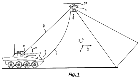
= figure 1 shows an application of the control
device according to the present invention on a
vehicle;
= figure 2 shows a flying device and a base unit
comprising a winch device controlled by the
control device according to the present
invention;
= figure 3 shows a flowchart of the control method
according to the present invention;
CA 02869285 2014-10-01
WO 2013/150442
PCT/1B2013/052618
4
= figure 4 shows a block diagram of the control
device according to the present invention.
With reference to the figures mentioned above, the method
for automatically controlling the movement of a winch
device 2, adapted to pull in or let out a cable "T", to
which at least one flying device 4 is connected, comprises
the following subsequent steps:
a) determining the relative position between said winch
device 2 and flying device 4;
b) calculating the optimal length of cable "T" as a
function of the relative position determined during
the previous step;
c) activating said winch device 2, so as to obtain the
desired length of cable "T" calculated during the
previous step;
d) repeating the sequence of steps a) c) for a desired
period, in order to obtain, in real time, the optimal
length of cable "T" as a function of the changes in
the relative position between the winch device 2 and
flying device 4.
The preferred sequence of the steps of the method according
to the present invention is shown in a flowchart
illustrated in figure 3.
Control device 5 associated with said method is adapted to
control a which device 2 applied to a base unit 3.
Winch device 2, therefore, is adapted to pull in or let out
a cable "T", which connects at least one flying device 4 to
said base unit 3, as shown, by way of example, in figure 2.
Said flying device 4 comprises at least one propulsion
device, not shown, which is adapted to allow flying device
4 itself to move, for example in "XYZ" space.
CA 02869285 2014-10-01
WO 2013/150442
PCT/1B2013/052618
Said propulsion device is, for example, at least one
propeller flush fitted to the rotor of at least one motor,
preferably an electric motor. The motor of said propulsion
device can be supplied with power by means of a battery
5 arranged on the inside of flying device 4, or it can be
supplied with power by means of a power supply line, for
example arranged inside said cable "T".
Preferably, said electric motor is supplied with a voltage
of 400+600 V, for example with a direct current. Said
flying device 4 is compliant with the standards for manging
and designing vehicles without pilot, also known as "UAV" o
"UAS".
The movements of said flying device 4 are activated only by
means of said propulsion device and can be performed
irrespective of cable "T" pulled in or let out by winch
device 2.
Said cable "T" is preferably made of a metal material, for
example mesh, with predetermined breaking loads, which is
able to flex and resist possible unintentional obstacles.
The size of said cable "T" preferably is of 6+8 mm of
diameter, with a length, for example, of 100m.
Winch device 2 preferably is a winch or a hoist comprising
an electric motor, which is also supplied with a voltage of
400+600 V in direct current.
Preferably, according to the method of the present
invention, the step a) of determining the relative position
comprises a first sub-step al) of determining the spatial
position of said winch device 2; a second sub-step a2) of
determining the spatial position of flying device 4; and a
further sub-step a3) of calculating the relative position
between flying device 4 and winch device 2. The order in
CA 02869285 2014-10-01
WO 2013/150442
PCT/1B2013/052618
6
which steps al) and a2) are performed can be reversed and
the result of the calculation performed in step a3) does
not change.
In order to determine the spatial position of winch device
2, according to step al), base unit 3 comprises a first
spatial locating system 51, for example a GPS system,
adapted to determine, with an uncertainty lower than one
meter, the spatial position in space "XYZ" defined by the
three Cartesian axes (X, Y, Z).
Furthermore, in order to determine the spatial position of
flying device 4, according to step a2), said at least one
flying device 4 comprises a second spatial locating system
52, for example a GPS system, adapted to determine, with an
uncertainty lower than one meter, the spatial position in
space "XYZ" defined by the three Cartesian axes (X, Y, Z).
Control device 5 comprises a data processing unit 50,
adapted to determine the relative position between said at
least one flying device 4 and said base unit 3 as a
function of the data obtained from said first and second
spatial locating systems (51, 52). Determining the relative
position between said at least one flying device 4 and said
base unit 3 leads to controlling, in real time, the
movement of said winch device 2, in order to obtain the
optimal length of cable "T" as a function of the changes in
the relative position. The changes in the relative distance
between said at least one flying device 4 and said base
unit 3 are in real time.
For the purposes of the present invention, the term "real
time" means that the operations aimed at calculating the
relative position are performed on a constant basis, at
predetermined time intervals, as a function of the speed at
CA 02869285 2014-10-01
WO 2013/150442
PCT/1B2013/052618
7
which the method according to the present invention is
carried out.
Said data processing unit 50 is, by way of example, a
microprocessor, adapted to process the data coming from the
first and second spatial locating systems (51, 52), thus
calculating the relative position between flying device 4
and base unit 3.
The calculation of the relative position between flying
device 4 and base unit 3, besides determining linear
distance "D", allows the user to obtain a plurality of
additional items of information, such as, for example,
elevation angle "a" and the azimuthal angle between flying
device 4 and base unit 3. These data, i.e. linear distance
"D", elevation angle "a" and azimuthal angle, allows the
user to unequivocally determine, for example in polar
coordinates, the position of flying device 4 with respect
to the reference position of base unit 3.
Said data processing unit 50, furthermore, is able to
perform the step b) of calculating the optimal length of
cable "T". Indeed, by means of a predetermined calculus,
for example a recursive algorithm, the user can calculate
the optimal tension of cable "T" and, as a consequence,
determine the optimal length as a function of the results
obtained in the step a3) of calculating the relative
position.
Preferably, said algorithm can be stored in a non-volatile
memory medium (54), aapted to be connected to said data
processing unit 50, as shown by way of example in figure 4.
For the purposes of the present invention, the term
. "optimal length" indicates a length of cable "T" that
allows flying device 4 to perform a predetermined movement,
CA 02869285 2014-10-01
WO 2013/150442
PCT/1B2013/052618
8
such as, for example, increasing the flying height by a
value lower than one meter.
The term "optimal tension" of cable "T" indicates a tension
of cable "T" that avoids the formation of loops in the
cable itself, which might get stuck in objects arranged
between base unit 3 and flying device 4. The tension of
cable "T" and, therefore, its length, in any case, are such
as to allow flying device 4 to be able to perform movements
without cable "T" reaching a tension state before control
device 5 has activated winch device 2 to let out cable "T".
The method according to the present invention comprises,
prior to the step b) of calculating the optimal length of
cable "T", a further step b0) of acquiring environmental
parameters, which are useful to calculate the optimal
length of cable "T". These parameters are, for example,
wind, humidity, etc. or presence of obstacles close to the
flying device and/or to cable "T" and/or to base unit 3.
Said environmental parameters can also include the
morphology of the ground close to unit 3.
In order to acquire said environmental parameters, control
device 5 and, in particular, data processing unit 51 are
adapted to be connected to a plurality of sensors 8, which
are adapted to acquire environmental parameters, such as
temperature, humidity and wind force, which are useful for
the calculation of the optimal length of cable "T".
Control device 5 is adapted to be connected to sensors,
which are able to detect the presence of obstacles and
objects, such as sonars, radars, infrared sensors and
visual sensors such as video cameras.
Said flying device 4 comprises a plurality of said sensors
8, which, besides acquiring environmental parameters, are
CA 02869285 2014-10-01
WO 2013/150442
PCT/1B2013/052618
9
able to provide images of places that cannot be directly
seen from the ground, where said base unit 3 is normally
positioned, so as to perform surveillance or patrol tasks
in sensitive areas. By means of said plurality of sensors
8, which are located on said flying device 4, it is
possible to patrol sensitive areas without the need for the
vehicles or the people to be directly close to said areas
to be subject to surveillance and patrol operations.
For the purposes of the present invention, the term
"sensitive areas" indicates those places where moving
around is difficult due to both natural and geopolitical
reasons, such as battle fields and border areas.
Said flying device 4, therefore, allows users to widen
their visual field without the need to directly expose
people or vehicles.
Said plurality of sensors 8 are preferably adapted to
monitor predetermined portions of space, which are
identified, for example, by an imaginary cone or visual
cone.
Said algorithm preferably is recursive, for example an
algorithm able to follow the movements of flying device 4
in real time.
According to the method of the present invention, the step
c) of activating said winch device 2 comprises a step cl)
of accelerating and decelerating the rotation speed of said
winch 2 according to a predetermined development in time.
Preferably, as a function of the acceleration with which
said flying device 4 moves with respect to unit 3, the
control device, thanks to data processing unit 50 and to
the calculation algorithm, is able to send an activation
signal to said winch device 2, which also specifies the
CA 02869285 2014-10-01
WO 2013/150442
PCT/1B2013/052618
acceleration with which said winch device 2 has to rotate
in order to let out or pull in cable "T".
The acceleration with which flying device 4 moves with
respect to unit 3, and vice versa, is determined as a
5 function of the data obtained from said first and second
spatial locating systems (51, 52).
Preferably, since winch device 2 has to follow the
movements of said flying device 4, the acceleration with
which said winch device 2 has to rotate to pull in or let
10 out cable "T" is directly proportional to the acceleration
with which flying device 4 moves.
Furthermore, in case the acceleration is equal to zero,
i.e. the movement of flying device 4 has a constant speed,
the rotation of winch device 2 to pull in or let out cable
"T" has an acceleration/deceleration that is such as to
cause the length of cable "T" to always be the optimal
length. In order to determine the rotation speed and the
acceleration/deceleration, one also has to take into
account the quantity of cable "T" already wound in winch
device 2, so as to cause cable "T" to be pulled in or let
out so as to always guarantee the optimal length of cable
"T" between winch device 2 and flying device 4. Indeed, as
a skilled already knows, the rotation speed of winch device
2 varies as a function of the length of cable wound in
winch device 2 itself.
Control device 5, thanks to said data processing unit 50,
is able to generate a control signal for the winch device
2, which is such as to obtain a rotation speed and/or an
acceleration/deceleration of the rotation speed according
to a predetermined function, so as to follow, in real time,
the relative movements between flying device 4 and unit 3.
CA 02869285 2014-10-01
WO 2013/150442
PCT/1B2013/052618
11
Said control signal is generated by said control device 5
as a function of a plurality of parameters, which are
obtained from said plurality of sensors 8 and from the data
obtained after step b).
Said function is determined in such a way that the length
of cable "T" between winch device 2 and flying device 4
always is the optimal length.
Said control device 5, in a first preferred embodiment, can
be applied to any winch device 2.
In an alternative preferred embodiment, control device 5 is
an integral part of winch device 2, said winch comprising
said control device 5.
In a further embodiment, control device 5 according to the
present invention is preferably applied to a vehicle 30,
which is considered as he above-mentioned base unit 3.
As shown in figure 1, said vehicle 30 comprises a winch
device 2, adapted to pull in or let out a cable "T", which
connects at least one flying device 4 to vehicle 30 itself.
In this embodiment, the vehicle is tracked and/or provided
with wheels.
Said vehicle 30 can also be a watercraft, for example a
boat. Said vehicle 30 can be robotized or provided with a
pilot.
Said cable "T", in the present embodiment, comprises at
least on data communication line 81 between said flying
device 4 and said control device 5, which, by way of
example, is arranged in said vehicle 30.
Both the data coming from said plurality of sensors 8 and
the commands for the movements of flying device 4 are
transferred by means of said data communication line 81.
CA 02869285 2014-10-01
WO 2013/150442
PCT/1B2013/052618
12
Preferably, flying device 4 is remotely controlled by a
console or joystick 83, which, by way of example, is
arranged in said vehicle 30.
The control signals from said console or joystick 83 are
sent by means of said data line 81.
Said plurality of sensors 8 are able to provide images of
places outside of the visual field of vehicle 30, i.e. not
directly visible.
In the preferred embodiment, said flying device 4
preferably is a small-dimension helicopter, which can move
along any desired direction, can rotate on itself and can
stand still, floating, for a desired amount of time, so as
to easily avoid obstacles along its path. The dimensions of
this flying device are small, both to reduce manufacturing
costs and to reduce the risk of being identified by third
parties; hence, such flying devices are also particularly
silent.
Said flying device 4 is moved by means of said console or
joystick 83, which can be portable or can be arranged on
said vehicle 30. Said console or joystick 83 is able to
communicate with said flying device 4 in wireless mode or
through a cable connection. Preferably, said console or
joystick 83 is arranged in vehicle 30 and communicates with
said flying device 4 through said data line 81, which is
comprised in cable "T".
The device and the method for controlling a winch device 2
according to the present invention allow said flying device
4 to be freely moved in order to perform surveillance
and/or patrol tasks in areas where there are many obstacle;
indeed, as a function of the data obtained from said
plurality of sensors 8 and of the relative position between
CA 02869285 2014-10-01
WO 2013/150442
PCT/1B2013/052618
13
flying device 3 and base unit 3 or vehicle 30, the length
of cable "T" is such as to reduce the chances of cable "T"
getting stuck in objects or obstacles available close to
the two devices (3, 4).
Furthermore, tanks to the fact that flying device 4 is
supplied with power by means of a power supply line
comprised in said cable "T", the duration of the patrol
operations can be much longer than the one of the patrol
operations performed with patrol devices having an
autonomous propulsion system; furthermore, thanks to
control device 5 according to the present invention and to
the method associated thereto, the movements carried out to
perform the surveillance and patrol operations are very
dynamic, which guarantees self-sufficient surveillance
devices.
One single cable "T" allows many different tasks to be
fulfilled, namely transmitting the energy necessary to move
flying device 4 to the propulsion device, receiving data
from said plurality of sensors 8, receiving data from said
spatial locating systems (51, 52), by means of said data
line 81, and, if necessary, transmitting commands for the
movement of flying device 4 generated by said console or
joystick 83. In alternative embodiments, like for example
the one shown in figure 4, part of the data transfer can be
performed in wireless mode.
This solution allows users to perform patrol and
surveillance tasks in special areas, with the possibility
to dynamically move, in real time, flying device 4 for a
desired amount of time. Furthermore, when applying control
device 5 according to the present invention on a vehicle
30, users can further improve the patrol and/or
CA 02869285 2014-10-01
WO 2013/150442
PCT/1B2013/052618
14
surveillance abilities of flying device 4, since they can
position vehicle 30 in the desired position, which may
change in time.
CA 02869285 2014-10-01
WO 2013/150442
PCT/1B2013/052618
NUMERICAL REFERENCES
Winch device 2
Base unit 3
Vehicle 30
5 Flying device 4
Control device 5
Data processing unit 50
First spatial locating system 51
Second spatial locating system 52
10 Non-volatile memory medium 54
Sensors 8
Data communication line 81
Console or joystick 83
Cable ANT II