Note: Descriptions are shown in the official language in which they were submitted.
CA 02871104 2016-03-10
SYSTEMS AND METHODS FOR
OPTIMAL SPACING OF HORIZONTAL WELLS
CROSS-REFERENCE TO RELATED APPLICATIONS
[0001] This application and PCT Patent Application No. PCT/US10/00774 are
commonly assigned to Landmark Graphics Corporation.
STATEMENT REGARDING FEDERALLY SPONSORED RESEARCH
[0002] Not applicable.
FIELD OF THE INVENTION
[0003] The present invention generally relates to systems and methods for
optimal
spacing of horizontal wells. More particularly, the present invention relates
to optimal spacing
of horizontal wells that maximizes coverage of a predetermined area within an
irregular
boundary by the horizontal wells.
BACKGROUND OF THE INVENTION
[0004] In today's oil and gas industry, wells that are deviated are most
common and,
more often than not, are deviated to horizontal. A horizontal well is
typically straight and
relatively flat over the final portion that extends between the heel and the
toe. The shape prior
to the heel will be whatever is necessary to get from the surface location to
that heel, building
to an inclination of roughly 90 degrees and turning to the intended azimuth,
achieving both by
the time the heel is reached. The heel and the toe may be referred to as
endpoints and the
portion between the heel and toe may be referred to as a lateral.
[0005] There are a number of established plays that utilize mass planning and
targeting
for horizontal drilling like the SAGD (steam assisted gravity drainage) in
Canada and the
Marcellus, Hornriver and Barnett shale gas plays. In order to optimize the
number of wells to
1
CA 02871104 2014-10-21
WO 2013/165437 PCT/US2012/036538
completely exploit one of these plays, companies are planning hundreds, and in
some case
thousands, of wells for an entire field, which is often very time-consuming
and requires
numerous resources. A field development plan therefore, will typically attempt
to fill one or
more predetermined polygonal areas with horizontal wells. An example of such a
polygonal area
is the area within a lease boundary, which has been reduced by a 'setback'
distance (the
minimum distance that all wells must be from the lease boundary). Each segment
between any
two sequential edge points along the boundary is thus, referred to as a
boundary segment.
[0006] There are numerous types of resource plays that require laterals to be
positioned
and spaced to fill a lease boundary. Two specific plays that utilize the
placement of laterals are
shale and heavy oil plays. The objective is to maximize the production
coverage within the lease
boundary based on lateral constraints, such as min/max lateral lengths,
lateral spacing and heel,
toe, heel,heel or toe,toe spacing. In order to fully maximize the production
coverage, the
horizontal wells are laterally spaced in proportion while maintaining
extremely accurate
subsurface depth. Likewise, the available surface locations and
surface/subsurface hazards must
be taken into account when positioning the horizontal wells.
[0007] In order to address the foregoing concerns, conventional techniques,
like that
described in WIPO Patent Application Publication No. WO 2011/115600, have
applied
horizontal targeting to fill a predetermined area, within a regular or
irregular boundary, with
horizontal wells. The horizontal targeting initially considers the boundary
filling as a two-
dimensional (2D) problem. In FIG. 3, a plan view 300 illustrates a
predetermined area within an
irregular boundary filled by horizontal wells using a conventional technique.
As demonstrated
by the open areas 302, conventional techniques may not maximize the production
coverage of
the predetermined area by the horizontal wells because the predetermined area
lies within an
2
CA 02871104 2014-10-21
WO 2013/165437 PCT/US2012/036538
irregular boundary, the horizontal wells must always be parallel and/or the
laterals must all have
the same length.
SUMMARY OF THE INVENTION
[0008] The present invention therefore, meets the above needs and overcomes
one or
more deficiencies in the prior art by providing systems and methods for
optimal spacing of
horizontal wells that maximizes coverage of a predetermined area within an
irregular boundary
by the horizontal wells.
[0009] In one embodiment, the present invention includes a method for
optimally spacing
horizontal wells within an irregular boundary, which comprises: i) determining
boundary
segments for the irregular boundary that fall within a correct azimuth range
using a computer
processor; ii) determining whether a heel, toe pair for a horizontal well
should be repositioned
based on the boundary segments that fall within the correct azimuth range; and
iii) repositioning
the heel, toe pair so that the heel, toe pair is not parallel to another heel,
toe pair for another
horizontal well nearest the heel, toe pair.
[0010] In another embodiment, the present invention includes a non-transitory
program
carrier device tangibly carrying computer executable instructions for
optimally spacing
horizontal wells within an irregular boundary, the instructions being
executable to implement: i)
determining boundary segments for the irregular boundary that fall within a
correct azimuth
range; ii) determining whether a heel, toe pair for a horizontal well should
be repositioned based
on the boundary segments that fall within the correct azimuth range; and iii)
repositioning the
heel, toe pair so that the heel, toe pair is not parallel to another heel, toe
pair for another
horizontal well nearest the heel, toe pair.
3
CA 02871104 2014-10-21
WO 2013/165437 PCT/US2012/036538
[0011] Additional aspects, advantages and embodiments of the invention will
become
apparent to those skilled in the art from the following description of the
various embodiments
and related drawings.
BRIEF DESCRIPTION OF THE DRAWINGS
[0012] The present invention is described below with references to the
accompanying
drawings in which like elements are referenced with like reference numerals,
and in which:
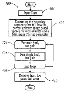
[0013] FIG. 1 is a flow diagram illustrating one embodiment of a method for
implementing the present invention.
[0014] FIG. 2A is a flow diagram illustrating one embodiment of an algorithm
for
performing step 106 in FIG. 1.
[0015] FIG. 2B is a continuation of the flow diagram illustrated in FIG. 2A.
[0016] FIG. 3 is a plan view illustrating a predetermined area within an
irregular
boundary filled by horizontal wells using a conventional technique.
[0017] FIG. 4 is a plan view illustrating the predetermined area in FIG. 3
filled by
horizontal wells using the present invention.
[0018] FIG. 5 is a plan view illustrating another predetermined area within an
irregular
boundary filled by horizontal wells using the present invention.
[0019] FIG. 6 is a block diagram illustrating one embodiment of a computer
system for
implementing the present invention.
DETAILED DESCRIPTION OF THE PREFERRED EMBODIMENTS
[0020] The subject matter of the preferred embodiments is described with
specificity
however, is not intended to limit the scope of the invention. The subject
matter thus, might also
be embodied in other ways to include different steps, or combinations of
steps, similar to the
4
CA 02871104 2014-10-21
WO 2013/165437 PCT/US2012/036538
ones described herein, in conjunction with other present or future
technologies. Although the
term "step" may be used herein to describe different elements of methods
employed, the term
should not be interpreted as implying any particular order among or between
various steps herein
disclosed unless otherwise expressly limited by the description to a
particular order. While the
following description refers to oil and gas wells, the systems and methods of
the present
invention are not limited thereto and may also be applied to other industries
to achieve 'similar
results.
Method Description
[0021] Referring now to FIG. 1, a flow diagram of one embodiment of a method
100 for
implementing the present invention is illustrated. The method 100 generally
illustrates a fanning
technique while still working with 2D coordinates, such that the horizontal
wells that are fanned
in 2D wind up being properly reflected in 3D. If the method 100 were applied
after moving to a
3D model, the amount of labor to accomplish the method 100 would require
substantially more
work, including shifting the intermediate targets to keep the horizontal wells
straight, checking
for horizontal wells that have become too close due to the pivoting, depth
shifting all targets to
maintain proper vertical relationships to the geology and checking against
depth specific hazards,
for example. The method 100 therefore, occurs between laying out the 2D
horizontal wells and
processing each heel, toe pair into 3D well path segments so the data can be
modified to move
from completely parallel heel, toe pairs to a fan fill pattern. Because depths
have not been
established for the x,y locations of the lateral heels and toes, nor any
intermediate points for
insuring that the lateral tracks the geology, the term "heel, toe pair" is
used herein to describe
each lateral.
CA 02871104 2014-10-21
WO 2013/165437 PCT/US2012/036538
[0022] In step 101, data is input for the method 100 using the client
interface and/or the
video interface described in reference to FIG. 6. The input data may include,
but is not limited
to: i) a boundary comprising boundary segments, wherein the edge points are
reflected in x,y
coordinates; ii) sets of predetermined heel, toe pairs for each horizontal
well, wherein each
endpoint is reflected as an x,y location; iii) an effective range
("RangeDistance"), which
represents the maximum distance in from the boundary that a lateral could be
positioned and still
considered for fanning; iv) a maximum change parameter ("MaximumChange"),
which
represents the maximum amount a planned azimuth may be altered in degrees; v)
a movement
percentage parameter ("MovementPercentage"), which represents the amount of
shift desired in
an attempt to line up the fanned endpoints (100%) compared to lining up the
pivot endpoints
(0%); and vi) a planned azimuth and additional data that may impact
positioning the horizontal
wells such as, for example, maximum reach to heel, minimum and maximum lateral
lengths,
beginning heel,heel and toe,toe spacing, required hazard clearance distance,
and a boundary
setback distance.
[0023] In step 102, boundary segments that fall into the correct azimuth range
are
determined. The boundary segments that fall into the correct azimuth range may
be determined
based upon the planned azimuth and the MaximumChange parameter from step 101,
Using this
data, the boundary segments that fall into the correct azimuth range may be
determined by the
azimuth for each boundary segment and whether it falls within the Maximum
Change of the
planned azimuth but not including the planned azimuth. The planned azimuth is
the azimuth
being used for the horizontal well spacing. Thus, if a planned azimuth of 295
is used, along
with a Maximum Change of 300, then any boundary segment will be considered
within the
correct azimuth range if the azimuth for that boundary segment is between 265
and 325'.
6
CA 02871104 2014-10-21
WO 2013/165437 PCT/US2012/036538
Likewise, the boundary segment will be considered within the correct azimuth
range if the
azimuth for the boundary segment is within that same 265 to 325 range. Any
boundary
segment that has an azimuth of exactly 295 will not be considered within the
correct azimuth
range, however, because the heel, toe pair will already be parallel to it.
[0024] In step 104, the method 100 selects a heel, toe pair from the data in
step 101 for
step 106. The method may select the head, tow pair at random or using any
other predetermined
criteria.
[0025] In step 106, the "fan single heel, toe pair" algorithm is executed for
the heel, toe
pair selected in step 104, which is described further in reference to FIGS. 2A-
2B,
[0026] In step 108, the method 100 determines if additional heel, toe pairs
are available
from the data in step 101. If there are additional heel, toe pairs, then the
method 100 returns to
step 104 to select another heel, toe pair. If there are no additional heel,
toe pairs, then the
method 100 proceeds to step 110.
[0027] In step 110, each heel, toe pair that crosses another heel, toe pair as
a result of the
fanning in step 106 is removed and the method 100 ends. As a result, each
horizontal well with a
heel, toe pair that is removed, is removed from the predetermined area within
the boundary.
Preferably, the heel, toe pair that crosses the most heel, toe pairs is
removed first and if there are
any heel, toe pairs that cross the same number of heel, toe pairs (e.g. each
crossing one another)
either or both may be removed.
[0028] Referring now to FIG. 2A, a flow diagram of one embodiment of the "fan
single
heel, toe" algorithm for performing step 106 in FIG. 1 is illustrated. The
method 200 generally
operates on the basic premise that the optimum placement of horizontal wells
over a
predetermined area, where the irregular boundary is not necessarily parallel
or perpendicular to
7
CA 02871104 2014-10-21
WO 2013/165437 PCT/US2012/036538
the planned azimuth, begins with a layout of parallel horizontal wells and, in
areas where it is
appropriate to do so, fans the horizontal wells by pivoting around either the
heel or toe such that
there is an increasing deviation away from the planned azimuth toward the
azimuth of the nearest
boundary segment. Appropriate areas for performing the method 200 are thus,
areas where there
is a nearby boundary segment that has an azimuth less than a user specified
delta from the
planned azimuth and where there are multiple horizontal wells from the same
row intersecting
the boundary segment.
[0029] In step 202, the nearest boundary segment(s) crossing a perpendicular
line
projected from the heel, toe and a midpoint between the heel, toe are
determined. Thus, for the
heel, toe pair selected in step 104, three lines are projected perpendicular
from the heel, toe and
the midpoint between the heel, toe to determine the nearest boundary
segment(s) from step 102
that cross(es) the three projected lines.
[0030] In step 204, the method 200 determines if the same boundary segment is
nearest
for all three projected lines. If the same boundary segment is not nearest for
all three projected
lines, then the method 200 returns to step 108 because the boundary segments
determined in step
202 are not consistent and near enough to this heel, toe pair for the method
200 to be effective.
If the same boundary segment is nearest for all three projected lines, then
the method 200
proceeds to step 206.
[0031] In step 206, the endpoint of the heel, toe pair selected in step 104
that is nearest
the boundary segment determined in step 202 is marked as Pointl and the
endpoint of the heel,
toe pair selected in step 104 that is farthest from the boundary segment
determined in step 202 is
marked as Point2. In addition, the distance from the nearest endpoint to the
boundary segment
8
CA 02871104 2014-10-21
WO 2013/165437 PCT/US2012/036538
determined in step 202 is saved as MinDist and the distance from the farthest
endpoint to the
boundary segment determined in step 202 is saved as MaxDist.
[0032] In step 208, the method 200 determines if MaxDist is greater than the
RangeDistance from step 101. If MaxDist is greater than RangeDistance, then
the method 200
returns to step 108 because the heel, toe pair selected in step 104 is too far
from the boundary
segment determined in step 202. If MaxDist is not is greater than
RangeDistance, then the
method 200 proceeds to step 210.
[0033] In step 210, the heel, toe pairs that intersect the boundary segment
determined in
step 202 and are closer to it than the heel, toe pair selected in step 104 are
counted. Thus, for the
first iteration of the method 200, there will be zero heel, toe pairs that
intersect the boundary
segment determined in step 210 and are closer to it than the heel, toe pair
selected in step 104.
[0034] In step 212, the method 200 determines if the count ("Count") from step
210 is
greater than 1. If the Count is greater than 1, then the method 200 returns to
step 108 because a
series of heel, toe pairs that all intersect the same boundary segment, when
fanned, will compress
and be effectively useless in terms of production coverage. If the Count is
not greater than 1,
then the method 200 proceeds to step 214.
[0035] In step 214, the method 200 determines if the Count is equal to 1 and
if the heel,
toe pair counted in step 210 intersects the boundary segment determined in
step 202. If the
Count is equal to 1 and if the heel, toe pair counted in step 210 intersects
the boundary segment
determined in step 202, then the method 200 returns to step 108. If the Count
is not equal to 1 or
if the Count is equal to 1, but the heel, toe pair counted in step 210 does
not intersect the
boundary segment determined in step 202, then the method 200 proceeds to step
216 in FIG. 2B.
9
CA 02871104 2014-10-21
WO 2013/165437 PCT/US2012/036538
[0036] In step 216, a line that is perpendicular to the heel, toe pair
selected step 104 is
computed through Pointl . This perpendicular line is stored as Line 1.
[0037] In step 218, RotationAngle is set equal to the difference between the
planned
azimuth for the heel, toe pair selected in step 104 and an azimuth for the
boundary segment
determined in step 202 multiplied by 1 - (MinDist/RangeDistance).
RotationAngle is thus, the
amount that Point2 is going to be rotated about Pointl . In this manner, the
heel, toe pair selected
in step 104 will be rotated all the way into the boundary segment determined
in step 202 when
the heel, toe pair is close enough to the boundary segment. If, however, the
heel, toe pair
selected in step 104 is at the RangeDistance, then it will not be rotated at
all.
[0038] In step 220, Point2 is rotated around Pointl by the RotationAngle.
[0039] In step 222, MovementDistance is set equal to the distance from Point2
to an
intersection of a line between Pointl and Point2 with Line I multiplied by the
Movement
Percentage parameter from step 101. Because the fanning represented by the
method 200 takes
heel, toe pairs that were formally lined up in straight rows with rows of
heels aligned and rows of
toes aligned, and pivots them in manner that leaves corners within the
boundary uncovered, it
may be desirable to shift the fanned heel, toe pair such that Pointl is moved
toward Point2 and
Point2 is moved toward a position that is aligned with the row of which it was
formerly a part.
The shifting therefore, is based upon the Movement Percentage parameter,
wherein 0% is no
shifting and 100% is shifting all the way so that the rotated points maintain
alignment.
[0040] In step 224, Pointl and Point2 are shifted along the line between
Pointl, Point2
by the MovementDistance.
[0041] In step 226, the method 200 determines if the heel, toe pair selected
in step 104 is
still valid ¨ meaning both the heel and the toe from the heel, toe pair are in
valid positions
CA 02871104 2014-10-21
WO 2013/165437 PCT/US2012/036538
wherein the heel, toe pair does not intersect the irregular boundary or any
hazard. If the heel, toe
pair selected in step 104 is still valid, then the method 200 returns to step
108. If the heel, toe
pair is not still valid, then the method 200 proceeds to step 228.
[0042] In step 228, Pointl and Point2 are shifted back to their original
positions because
the heel, toe pair is not still valid, and the method 200 returns to step 108.
[0043] As illustrated by a comparison of the plan view 300 in FIG. 3 and the
plan view
400 in FIG. 4, the open areas 302 in FIG. 3 are now covered by adding heel,
toe pairs and
fanning existing heel, toe pairs in the open areas 302 within the irregular
boundary. Another
example of the method 200 is illustrated by the plan view 500 in FIG. 5 of
another
predetermined area within an irregular boundary filled by horizontal wells.
The method 200
therefore, determines the best lateral spacing for horizontal wells to
maximize production
coverage across an area within an irregular boundary, while positioning each
individual target at
varied subsurface depths. This lateral spacing can also be adjusted to
complete a pattern that
maximizes production coverage within the irregular boundary.
System Description
[0044] The present invention may be implemented through a computer-executable
pro-
gram of instructions, such as program modules, generally referred to as
software applications or
application programs executed by a computer. The software may include, for
example, routines,
programs, objects, components, and data structures that perform particular
tasks or implement
particular abstract data types. The software forms an interface to allow a
computer to react
according to a source of input. AssetPlannermi, which is a commercial software
application
marketed by Landmark Graphics Corporation, may be used as an interface
application to
implement the present invention. The software may also cooperate with other
code segments to
11
CA 02871104 2014-10-21
WO 2013/165437 PCT/US2012/036538
initiate a variety of tasks in response to data received in conjunction with
the source of the
received data. The software may be stored and/or carried on any variety of
memory media such
as CD-ROM, magnetic disk, bubble memory and semiconductor memory (e.g.,
various types of
RAM or ROM). Furthermore, the software and its results may be transmitted over
a variety of
carrier media such as optical fiber, metallic wire and/or through any of a
variety of networks
such as the Internet.
[0045] Moreover, those skilled in the art will appreciate that the invention
may be
practiced with a variety of computer-system configurations, including hand-
held devices,
multiprocessor systems, microprocessor-based or programmable-consumer
electronics,
minicomputers, mainframe computers, and the like. Any number of computer-
systems and
computer networks are acceptable for use with the present invention. The
invention may be
practiced in distributed-computing environments where tasks are performed by
remote-
processing devices that are linked through a communications network. In a
distributed-
computing environment, program modules may be located in both local and remote
computer-
storage media including memory storage devices. The present invention may
therefore, be
implemented in connection with various hardware, software or a combination
thereof, in a
computer system or other processing system.
[0046] Referring now to FIG. 6, a block diagram of one embodiment of a system
for
implementing the present invention on a computer is illustrated, The system
includes a
computing unit, sometimes referred to as a computing system, which contains
memory,
application programs, a database, a viewer, ASCII files, a client interface, a
video interface and a
processing unit. The computing unit is only one example of a suitable
computing environment
12
CA 02871104 2014-10-21
WO 2013/165437 PCT/US2012/036538
and is not intended to suggest any limitation as to the scope of use or
functionality of the
invention.
[0047] The memory primarily stores the application programs, which may also be
described as program modules containing computer-executable instructions,
executed by the
computing unit for implementing the present invention described herein and
illustrated in FIGS.
1, 2A-2B and 4-5. The memory therefore, includes OpenWorksTM, which may be
used as a
database to supply data and/or store data results such as, for example, the
input data and
horizontal well spacing plans. ASCII files may also be used to supply data
and/or store the data
results. The memory also includes DecisionSpace Desktopim, which may be used
as a viewer to
display the data and data results. The horizontal well spacing module in
AssetPlannerm uses the
input data to determine the spacing and positioning requirements for the
horizontal wells. In one
application, for example, polygonal areas representing a predetermined area
within an irregular
lease boundary may be drawn directly in DecisionSpace DesktopTm using the
client interface and
TracPlannerTm. In another application, for example, a polygonal area
representing a
predetermined area within an irregular lease boundary could be defined
directly in TracPlannerm
using the client interface or by importing it from the ASCII files as
specified by the client
interface. Once the boundary is defined, the client interface may be used to
enter other
horizontal well spacing parameters. These parameters may dictate the desired
horizontal well
lengths, spacing and azimuth, which are processed by the horizontal well
spacing module in
AssetPlannerm to generate an optimal horizontal well spacing plan. The
horizontal well spacing
module thus, processes the input data using the methods described in reference
to FIGS. 1 and
2A-2B to generate the optimal horizontal well spacing plan. Although
AssetPlanner., may be
used to determine the spacing and positioning requirements for horizontal
wells, other interface
13
CA 02871104 2014-10-21
WO 2013/165437 PCT/US2012/036538
applications may be used, instead, or the horizontal well spacing module may
be used as a stand-
alone application. TracPlannerm, DecisionSpace Desktopm and OpenWorksTm are
commercial
software applications marketed by Landmark Graphics Corporation.
[0048] Although the computing unit is shown as having a generalized memory,
the
computing unit typically includes a variety of computer readable media. By way
of example,
and not limitation, computer readable media may comprise computer storage
media. The
computing system memory may include computer storage media in the form of
volatile and/or
nonvolatile memory such as a read only memory (ROM) and random access memory
(RAM). A
basic input/output system (BIOS), containing the basic routines that help to
transfer information
between elements within the computing unit, such as during start-up, is
typically stored in ROM.
The RAM typically contains data and/or program modules that are immediately
accessible to
and/or presently being operated on by the processing unit. By way of example,
and not
limitation, the computing unit includes an operating system, application
programs, other program
modules, and program data.
[0049] The components shown in the memory may also be included in other
removable/nonremovable, volatile/nonvolatile computer storage media or they
may be
implemented in the computing unit through an application program interface
("API") or cloud
computing, which may reside on a separate computing unit connected through a
computer
system or network. For example only, a hard disk drive may read from or write
to
nonremovable, nonvolatile magnetic media, a magnetic disk drive may read from
or write to a
removable, nonvolatile magnetic disk, and an optical disk drive may read from
or write to a
removable, nonvolatile optical disk such as a CD ROM or other optical media.
Other
removable/non-removable, volatile/nonvolatile computer storage media that can
be used in the
14
CA 02871104 2014-10-21
WO 2013/165437 PCT/US2012/036538
exemplary operating environment may include, but are not limited to, magnetic
tape cassettes,
flash memory cards, digital versatile disks, digital video tape, solid state
RAM, solid state ROM,
and the like, The drives and their associated computer storage media discussed
above provide
storage of computer readable instructions, data structures, program modules
and other data for
the computing unit.
[0050] A client may enter commands and information into the computing unit
through
the client interface, which may be input devices such as a keyboard and
pointing device,
commonly referred to as a mouse, trackball or touch pad. Input devices may
include a
microphone, joystick, satellite dish, scanner, or the like. These and other
input devices are often
connected to the processing unit through a system bus, but may be connected by
other interface
and bus structures, such as a parallel port or a universal serial bus (USB).
[0051] A monitor or other type of display device may be connected to the
system bus via
an interface, such as a video interface. A graphical user interface ("GUI")
may also be used with
the video interface to receive instructions from the client interface and
transmit instructions to
the processing unit. In addition to the monitor, computers may also include
other peripheral
output devices such as speakers and printer, which may be connected through an
output
peripheral interface.
[0052] Although many other internal components of the computing unit are not
shown,
those of ordinary skill in the art will appreciate that such components and
their interconnection
are well known.
[0053] While the present invention has been described in connection with
presently
preferred embodiments, it will be understood by those skilled in the art that
it is not intended to
limit the invention to those embodiments. Although the illustrated embodiments
of the present
CA 02871104 2016-03-10
invention relate to the positioning and spacing of horizontal oil and gas
wells, the present
invention may be applied to any other type of well in other fields and
disciplines. It is therefore,
contemplated that various alternative embodiments and modifications may be
made to the
disclosed embodiments without departing from the scope of the invention
defined by the
appended claims and the equivalents thereof.
16