Note: Descriptions are shown in the official language in which they were submitted.
CA 02875613 2016-04-08
1
FIELD OF VIEW TRAFFIC SIGNAL PREEMPTION
FIELD OF THE INVENTION
The present invention is generally directed to servicing preemption requests
for traffic control signals.
BACKGROUND
Traffic signals have long been used to regulate the flow of traffic at
intersections. Generally, traffic signals have relied on timers or vehicle
sensors to
determine when to change traffic signal lights, thereby signaling alternating
directions of traffic to stop, and others to proceed.
Emergency vehicles, such as police cars, fire trucks and ambulances,
generally have the right to cross an intersection against a traffic signal.
Emergency vehicles have in the past typically depended on horns, sirens and
flashing lights to alert other drivers approaching the intersection that an
emergency vehicle intends to cross the intersection. However, due to hearing
impairment, air conditioning, audio systems and other distractions, often the
driver
of a vehicle approaching an intersection will not be aware of a warning being
emitted by an approaching emergency vehicle.
Traffic control preemption systems assist authorized vehicles (police, fire
and other public safety or transit vehicles) through signalized intersections
by
making preemption requests to the intersection controllers that controls the
traffic
lights at the intersections. The intersection controller may respond to the
preemption request from the vehicle by changing the intersection lights to
green in
the direction of travel of the approaching vehicle. This system improves the
response time of public safety personnel, while reducing dangerous situations
at
intersections when an emergency vehicle is trying to cross on a red light. In
addition, speed and schedule efficiency can be improved for transit vehicles.
CA 02875613 2014-12-03
WO 2013/184438 PCT/US2013/042865
2
There are presently a number of known traffic control preemption systems
that have equipment installed at certain traffic signals and on authorized
vehicles.
One such system in use today is the OPTICOM system. This system utilizes a
high power strobe tube (emitter), which is located in or on the vehicle, that
generates light pulses at a predetermined rate, typically 10 Hz or 14 Hz. A
receiver, which includes a photodetector and associated electronics, is
typically
mounted on the mast arm located at the intersection and produces a series of
voltage pulses, the number of which are proportional to the intensity of light
pulses
received from the emitter. The emitter generates sufficient radiant power to
be
detected from over 2500 feet away. The conventional strobe tube emitter
generates broad spectrum light. However, an optical filter is used on the
detector
to restrict its sensitivity to light only in the near infrared (IR) spectrum.
This
minimizes interference from other sources of light.
Intensity levels are associated with each intersection approach to determine
when a detected vehicle is within range of the intersection. Vehicles with
valid
security codes and a sufficient intensity level are reviewed with other
detected
vehicles to determine the highest priority vehicle. Vehicles of equivalent
priority are
selected in a first come, first served manner. A preemption request is issued
to the
controller for the approach direction with the highest priority vehicle
travelling on it.
Another common system in use today is the OPTICOM GPS priority control
system. This system utilizes a GPS receiver in the vehicle to determine
location,
speed and heading of the vehicle. The information is combined with security
coding information that consists of an agency identifier, vehicle class, and
vehicle
ID, and is broadcast via a proprietary 2.4 GHz radio.
An equivalent 2.4 GHz radio located at the intersection along with
associated electronics receives the broadcasted vehicle information.
Approaches
to the intersection are mapped using either collected GPS readings from a
vehicle
traversing the approaches or using location information taken from a map
database. The vehicle location and direction are used to determine on which of
the
mapped approaches the vehicle is approaching toward the intersection and the
relative proximity to it. The speed and location of the vehicle is used to
determine
the estimated time of arrival (ETA) at the intersection and the travel
distance from
the intersection. ETA and travel distances are associated with each
intersection
approach to determine when a detected vehicle is within range of the
intersection
CA 02875613 2014-12-03
WO 2013/184438 PCT/US2013/042865
3
and therefore a preemption candidate. Preemption candidates with valid
security
codes are reviewed with other detected vehicles to determine the highest
priority
vehicle. Vehicles of equivalent priority are selected in a first come, first
served
manner. A preemption request is issued to the controller for the approach
direction
with the highest priority vehicle travelling on it.
With metropolitan wide networks becoming more prevalent, additional
means for detecting vehicles via wired networks, such as Ethernet or fiber
optics,
and wireless networks, such as cellular, Mesh or 802.11b/g, may be available.
With network connectivity to the intersection, vehicle tracking information
may be
delivered over a network medium. In this instance, the vehicle location is
either
broadcast by the vehicle itself over the network or it may be broadcast by an
intermediary gateway on the network that bridges between, for example, a
wireless
medium used by the vehicle and a wired network on which the intersection
electronics resides. In this case, the vehicle or an intermediary reports, via
the
network, the vehicle's security information, location, speed and heading along
with
the current time on the vehicle, intersections on the network receive the
vehicle
information and evaluate the position using approach maps as described in the
Opticom GPS system. The security coding could be identical to the Opticom GPS
system or employ another coding scheme.
Prior approaches to traffic signal preemption have a number of
disadvantages. For optical systems, a line of sight is required from the
emitter on
the vehicle to the receiver at the intersection. Fog, trees, and curves in the
road
may negatively impact the performance of an optical system. GPS and network-
based systems use approach maps that are constructed for each intersection.
Extensive effort is required to create the necessary maps for each different
approach to each intersection.
SUMMARY
In one embodiment, a method is provided for issuing preemption requests.
The method includes determining by an on-vehicle circuit arrangement, a
location
and a heading of a vehicle. The on-vehicle circuit arrangement determines
boundaries of a geo-window in response to the determined location and heading.
The on-vehicle circuit arrangement also determines whether or not any one of a
plurality of intersections is located within the boundaries of the geo-window.
In
CA 02875613 2014-12-03
WO 2013/184438 PCT/US2013/042865
4
response to determining that one of the plurality of intersections is located
within
the boundaries of the geo-window, a preemption request is transmitted from the
vehicle to an intersection controller at the one of the plurality of
intersections.
In another embodiment, an on-vehicle system for issuing traffic signal
preemption requests is provided. A receiver is configured and arranged to
receive
a location signal indicating a location of a vehicle. A storage device is
configured
with geographical data that identify locations of a plurality of traffic
signals. A
processor is coupled to the receiver and to the storage device. The processor
is
configured and arranged to determine a location and a heading of the vehicle
in
response to the location signal. The processor generates a representation of a
geo-window from the location and heading of the vehicle. Based on the stored
geographical data the processor determines whether or not any one of the
traffic
signals is located within boundaries of the geo-window. In response to
determining
that one of the traffic signals is located within the boundaries of the geo-
window, a
preemption request is generated. A transmitter is coupled to the processor and
is
configured and arranged to transmit the preemption request to an intersection
controller of the one of the traffic signals.
A method for issuing preemption requests is provided in another
embodiment. The method repeatedly determines boundaries of a geo-window
based on locations and headings of a vehicle as the vehicle is traveling along
a
roadway. The method determines whether or not any one of a plurality of
intersections is located within the boundaries of the geo-window in response
to
changed boundaries of the geo-window. In response to determining that one of
the
plurality of intersections is located within the boundaries of the geo-window,
a
preemption request is transmitted from the vehicle to an intersection
controller at
the one of the plurality of intersections.
An apparatus for issuing preemption requests is provided in another
embodiment. The apparatus includes means for repeatedly determining
boundaries of a geo-window based on locations and headings of a vehicle as the
vehicle is traveling along a roadway; means for determining whether or not any
one
of a plurality of intersections is located within the boundaries of the geo-
window in
response to changed boundaries of the geo-window; and means, responsive to
determining that one of the plurality of intersections is located within the
boundaries
CA 02875613 2014-12-03
WO 2013/184438 PCT/US2013/042865
of the geo-window, for transmitting a preemption request from the vehicle to
an
intersection controller at the one of the plurality of intersections.
The above summary of the present invention is not intended to describe
each disclosed embodiment of the present invention. The figures and detailed
5 description that follow provide additional example embodiments and
aspects of the
present invention.
BRIEF DESCRIPTION OF THE DRAWINGS
Other aspects and advantages of the invention will become apparent upon
review of the Detailed Description and upon reference to the drawings in
which:
FIG. 1 is a diagram that shows geo-windows associated with a vehicle as
the vehicle travels along a roadway;
FIGS. 2-1 and 2-2 show a flowchart of a process for generating preemption
requests based on intersection locations relative to a geo-window maintained
by
on-vehicle processing circuitry;
FIG. 2-3 shows an example geo-window which is referenced in the
description of the process steps for determining whether or not an
intersection is
within the boundaries of the geo-window;
FIG. 3-1 is a flow diagram that shows a process by which the geo-window is
created and updated based on the location, heading, and speed;
FIG. 3-2 is a graph that shows the calculation of the coordinates of the
midpoint of the leading edge;
FIG. 3-3 is a graph that shows the calculation of one corner of the geo-
window;
FIG. 3-4 is a graph that shows the calculation of the three other corners of
the geo-window;
FIG. 4 shows a primary geo-window 402 and a supplemental geo-window
404;
FIG. 5 is a flowchart that shows a process for generating a supplemental
geo-window; and
FIG. 6 is a block diagram showing a circuit arrangement for generating
preemption requests based on intersection locations relative to geo-windows
generated as the vehicle is moving.
CA 02875613 2014-12-03
WO 2013/184438 PCT/US2013/042865
6
DETAILED DESCRIPTION
The various embodiments of the invention provide a system and method for
traffic signal preemption that addresses the disadvantages of prior systems.
The
system does not require a line-of-sight from the vehicle to the intersection.
In
addition, the system is easily configured.
In one embodiment, an on-vehicle system for issuing traffic signal
preemption requests is provided. The system includes a receiver that is
configured
and arranged to receive a location signal indicating the location of the
vehicle. A
processor in the system uses the location information to determine whether or
not a
request should be made to preempt a nearby traffic signal. In making the
determination, the system uses the location information and heading of the
vehicle
to define an area that extends from the vehicle in the direction of travel.
The
defined area is referred to as the geo-window. The size of the window may be
defined as a function of the speed of the vehicle or may be static, depending
on
implementation requirements. Data that indicate the geographical locations of
a
plurality of intersection are used by the on-vehicle system to determine
whether or
not an intersection falls within the boundaries of the geo-window. If the
system
determines that an intersection is located within the boundaries of the geo-
window,
a preemption request is generated. A transmitter transmits the preemption
request
to the intersection controller at the intersection.
The on-vehicle system determines whether or not to request preemption
based on the geo-window it creates. This eliminates the need to create
approach
maps for the multiple approaches at all the controlled intersections in a
jurisdiction.
Having the decision made on-vehicle instead of at the intersections permits
the
decision making to be integrated with other vehicle management systems, such
as
route management systems. This allows route-specific information to be
provided
to the on-vehicle system as well as control over the enabling and disabling of
the
capability to request preemption.
As used herein, a preemption request refers to both preemption requests
that emanate from emergency vehicles, as well as to what are sometimes
referred
to as priority requests, which emanate from mass transit vehicles, for
example.
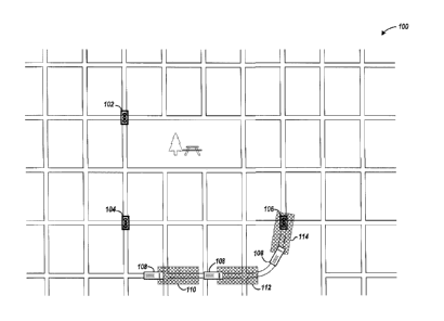
FIG. 1 is a diagram that shows geo-windows associated with a vehicle as
the vehicle travels along a roadway. The map 100 shows a grid of roads and
controlled intersections, which are represented by traffic signal icons 102,
104, and
CA 02875613 2014-12-03
WO 2013/184438 PCT/US2013/042865
7
106. The vehicle 108 is shown at three different positions in order to depict
the
vehicle approaching intersection 106. At each of the three positions, the on-
vehicle
preemption system generates a geo-window. The geo-windows are shown as
blocks 110, 112, and 114.
For emergency vehicles, the on-vehicle preemption system may be activated
when the vehicle is traveling to the site of the emergency. For mass transit
vehicles, the on-vehicle preemption system may be activated when the vehicle
is
traveling its assigned route.
Once activated, as the vehicle is moving the system repeatedly determines
the boundaries of the geo-window and checks whether or not the location of the
intersection is within the boundaries of the geo-window. The boundaries of the
geo-window are determined based on the vehicle location and heading, which may
be determined by way of a satellite positioning system, such as the GPS, or
from a
terrestrial system. The speed of the vehicle may be used in determining the
size of
the geo-window. Once the location of the traffic signal 106 falls within the
geo-
window 114, the on-vehicle system generates and transmits a preemption request
to the traffic signal 106.
FIGs. 2-1 and 2-2 show a flowchart of a process for generating preemption
requests based on intersection locations relative to a geo-window maintained
by
on-vehicle processing circuitry. At block 202, the location of the vehicle is
determined, and at block 204, the heading and speed of the vehicle are
determined. As indicated above, the location and heading may be determined
using the GPS or a terrestrial system.
Based on the location, heading, and speed, the process determines the
boundaries of the geo-window at block 206. In an alternative embodiment, the
speed of the vehicle may be ignored and the size of the geo-window may be
fixed.
FIGS. 3-1 through 3-4 further describe the process of determining the
boundaries of
the geo-window. In one embodiment, the geo-window is rectangular, and the four
corners of the rectangle are specified as GPS coordinates. FIG. 2-3 shows an
example geo-window which is referenced in the description of the process steps
for
determining whether or not an intersection is within the boundaries of the geo-
window.
At block 208, the process converts the coordinates of the location of the
vehicle to a decimal degrees format (e.g., 123.005 degrees) from a format of
the
CA 02875613 2014-12-03
WO 2013/184438 PCT/US2013/042865
8
World Geodetic System. At block 210, the process computes conversion factors
based on the longitude and latitude of the vehicle. The conversion factors are
used
to compensate for changes in the distance between longitudinal points due to
convergence of lines of longitude and latitude at the poles. The conversion
factors
are used as longitude and latitude correction values in block 214.
At block 212, the process retrieves the location of the next intersection to
process from the database. For ease of reference, geo-location is used to
refer to
the location of the intersection. In one embodiment, multiple locations may be
associated with the location of the intersection in order to compensate for
curves in
the road. An example case is for an intersection at the end of a cloverleaf
off-ramp.
The GPS coordinates of additional locations along the cloverleaf may be
associated with the intersection, such that when any of those additional
locations
fall within the geo-window, a preemption request is issued to preempt the
traffic
signal. This allows the rectangular geo-window to be used in issuing
preemption
requests for approaches of different shapes, while obviating the need to
construct
extensive approach maps along the curved road. These additional locations are
used as geo-locations in the process of FIGS. 2-2 and 2-3.
At block 214, the process determines the coordinates of the geo-location
relative to the location of the vehicle. The relative coordinates of the geo-
location
are labeled (Xi, Yi) and are shown in the geo-window of FIG. 2-3. The
longitude of
the geo-location is Xi = (intersection longitude ¨ vehicle longitude) *
longitude
correction. The latitude of the geo-location is Yi = (intersection latitude ¨
vehicle
latitude) * latitude correction. The process continues at decision block 216
in FIG.
2-2.
Taken together, decision blocks 216, 218, and 220 screen for intersections
that are clearly outside boundaries of the geo-window. Decision blocks 216 and
218 check whether or not the relative coordinates are beyond the minimum and
maximum X and Y coordinates of the geo-window. In the geo-window shown in
FIG. 2-3, the minimum X coordinate is X,,4, the maximum X coordinate is Xw2,
the
minimum Y coordinate is Yw3, and the maximum Y coordinate is Ywi. If the
relative
coordinates are beyond the minimum and maximum X and Y coordinates of the
geo-window, the process is directed to decision block 242 since the geo-
location is
not within the geo-window. Otherwise, processing continues at decision block
220.
CA 02875613 2014-12-03
WO 2013/184438 PCT/US2013/042865
9
Decision block 220 checks whether or not the relative geo-location is less
than a configurable number of degrees (e.g., 45 degrees) away from the heading
of
the vehicle. If the absolute value of the difference between the intersection
(J in
FIG. 2-3) and the heading of the vehicle (H) is less than the configured
number of
degrees, then the process continues at block 222. Otherwise, the process is
directed to decision block 242. Thus, a geo-location may be within the
boundaries
of the rectangle (FIG. 2-3) formed by (Xwl, Yw2), (Xw2, Yw2), (Xw3, Yw3), and
(Xwa,
Yw4) but not qualify as being within the geo-window for triggering a
preemption
request.
At block 222, the process computes lengths of vectors that are used in
computing dot products and a cross product, which are used in determining
whether or not the relative geo-location is within the geo-window. At block
224, a
forward dot product (DPF) is calculated as DPF = (VX1 * AX1) + (VY1 * AY1). At
block 226, a backward dot product (DPB) is calculated as DPB = (VX2 * AX2) +
(VY2 * AY2). In the example shown in FIG. 2-3, the forward dot product (DPF)
is
the distance from 0,0 to the projection of the relative geo-location onto the
vector L.
The backward dot product (DPB) is the distance from the projection of the
relative
location of the intersection onto the vector L to Xm,
At block 228, a cross product CP is calculated as:
CP = KVX1 * AY1) ¨ (AX1 * VY1)I / L
The cross product CP represents the distance from vector L to the relative geo-
location, Xi,
Decision block 230 uses the forward dot product, the backward dot product,
and the cross product to determine whether or not the relative geo-location is
within
the geo-window. If the cross product (CP) is less than or equal to 1/2 the
width of
the geo-window (W), and either the forward dot product (DPF) and the backward
dot product (DPB) are both greater than or equal to 0, or at least one of the
absolute value of the forward dot product (DPF) and the absolute value of the
backward dot product (DPB) is less than or equal to L, then the relative geo-
location falls within the geo-window. The comparison of the cross product (CP)
to
W is used to check whether or not the length of CP (see FIG. 2-3) extends
outside
of either edge Xwa, Ywa to Xwl, Ywi or edge Xw3, Yw3 to Xw2, Yw2. The
comparisons
of the forward dot product (DPF) and backward dot product (DPB) to the origin
and
L are used to check whether the relative geo-location projects onto L, or
whether
CA 02875613 2014-12-03
WO 2013/184438 PCT/US2013/042865
the intersection location lies beyond 0,0 or Xm, Ym. If the geo-location is
within the
geo-window, block 230 directs the process to decision block 232. A track list
is
maintained to track which intersections were previously determined to fall
within the
geo-window and a preemption request issued. Preemption requests need not be
5 reissued for such intersections. If the current geo-location is not yet
on the track
list, at block 234 the geo-location is added to the track list and a
preemption
request is issued to the intersection. Otherwise, the process is directed to
decision
block 246.
If at decision block 230 the geo-location is determined to be outside the geo-
10 window, the process continues at decision block 242. Decision block 242
tests
whether a geo-location that has been determined to fall outside the geo-window
is
on the track list. If so, at block 244 the geo-location is removed from the
track list,
and a preemption clear message is sent to the intersection. The process
continues
at block 246. If the geo-location is not on the track list, decision block 242
directs
the process to decision block 246, at which it is determined whether or not
there
are more geo-locations to process. If there are more geo-locations not yet
considered relative to the current vehicle location, the process returns to
block 212
to repeat the determining of the boundaries of the geo-window and checking
whether or not any intersections fall within the boundaries. Otherwise, the
process
is directed to block 202 to obtain a new location of the vehicle and repeat
the
process of determining whether or not any intersections fall within the geo-
window
based on the changed vehicle location.
In another embodiment, the process may consider multiple geo-windows.
For example, if a turn signal has been activated, a supplemental geo-window
may
be generated. The supplemental geo-window extends from an intersection that
the
vehicle is approaching and in the direction of the turn signal. If an
intersection is
located within the boundaries of the supplemental geo-window, preemption
requests may be sent both to the intersection in the main geo-window and the
intersection in the supplemental geo-window. This feature is further described
in
FIGs. 4 and 5.
In an embodiment in which a supplemental geo-window is generated in
response to activation of a turn signal and to account for a possible change
in
direction, the process may further include making a determination as to which
of
the intersections that are within the primary geo-window preemption requests
CA 02875613 2014-12-03
WO 2013/184438 PCT/US2013/042865
11
should be sent. For example, if there are multiple intersections in the
primary geo-
window and the turn signal is activated, the on-vehicle system may disregard
the
intersection(s) that lies beyond the intersection nearest the vehicle. In
disregarding
an intersection, preemption requests are not sent to the intersection
controller at
that intersection.
In another embodiment, the geo-fence may temporarily assume a
trapezoidal shape in response to the heading of the vehicle changing such as
when
the vehicle is turning. This may be beneficial for situations in which an
emergency
vehicle is entering a roadway from a fire station or parking lot, for example.
In response to determining that the intersection is located within the geo-
window or there being a location that is associated with an intersection and
within
the boundaries of the geo-window, the preemption request is transmitted to the
identified intersection at block 212. Depending on application requirements,
the
preemption request may be transmitted by way of short-range radio signal or
optical emitter, or by wide area network or Wi-Fi, for example.
In order to preempt the desired traffic signal, and since preemption requests
are transmitted to intersections identified by the on-vehicle system, the
transmitted
preemption requests include information that identifies the targeted
intersection(s).
In one embodiment, this may be a unique intersection identifier or a network
address, such as an IP address. In addition, the preemption request further
includes data that indicate at least one of signal phase, heading, or
position. The
signal phase, heading, and position data permit the intersection controller to
force
or extend a green light in the desired direction.
FIG. 3-1 is a flow diagram that shows a process by which the geo-window is
created and updated based on the location, heading, and speed. In one
embodiment, the system is configurable to make the size of the geo-window
either
inversely proportional to the speed of the vehicle or directly proportional to
the
speed.
Configuring the system to size the geo-window inversely proportional to
speed may be useful in scenarios where the vehicle is stopped, such as a bus
stop,
in order to provide sufficient time for intersection controllers in the path
of the
vehicle to schedule an extended green phase of the traffic signal. When
deployed
in an emergency vehicle, the system may be configured to size the geo-window
in
direct portion to the speed since a fast moving vehicle may arrive at an
intersection
CA 02875613 2014-12-03
WO 2013/184438 PCT/US2013/042865
12
in less time. The system may be further configured to employ both a minimum
and
a maximum length for the geo-window. The minimum length allows a minimum
number of intersections to fall within the geo-window when the vehicle is not
moving, and the maximum length limits the number of intersections that would
fall
within the geo-window for a fast moving vehicle.
If the system is configured to size the geo-window in inverse proportion to
speed, decision block 302 directs the process to block 304. At block 304, the
length of the geo-window is computed to be the greater of the minimum
distance, or
the maximum distance ¨ (maximum time * speed). The maximum time is a
configurable parameter that is the maximum period of time to look ahead (the
product of the maximum time and speed provides a distance for subtracting from
the maximum distance).
If the system is configured to size the geo-window directly proportional to
speed, decision block 306 directs the process to block 308. At block 308, the
length of the geo-window is computed to be the lesser of the maximum distance,
or
the minimum distance + (maximum time * speed).
If the system is configured to use a fixed size geo-window, at block 310, the
length of the geo-window is set to the static length setting. For both the
dynamic
and fixed geo-window sizes, the width of the window is static, but may be
implemented as a setting that is configurable by the user.
Blocks 312, 314, and 316 determine the Cartesian coordinates of the four
corners of the geo-window based on the determined geo-window length and the
heading of the vehicle.
At block 312, the process determines the coordinates of the midpoint of the
leading edge of the geo-window using the determined length and the heading of
the
vehicle. FIG. 3-2 is a graph that shows the calculation of the coordinates of
the
midpoint of the leading edge. For a rectangular geo-window that extends from
the
vehicle into the direction of travel, the leading edge is the side that is
farthest from
the vehicle, and the trailing edge is opposite the leading edge and is the
side
nearest the vehicle. The other two sides of the geo-window are generally
parallel
to the heading of the vehicle.
As shown in FIG. 3-2, the midpoint of the leading edge of the geo-window is
labeled with the coordinates Xm, Ym. The heading, H, is measured from the Y
axis.
CA 02875613 2014-12-03
WO 2013/184438 PCT/US2013/042865
13
The x-coordinate is calculated as Xm = length * sin(H), and the y-coordinate
as Ym
= length * sin(90-H).
At block 314, one corner of the leading edge of the geo-window is
determined. FIG. 3-3 is a graph that shows the calculation of one corner of
the
geo-window. For ease of expression, the fixed width of the geo-window is 2W,
and
1/2 the width is W.
The length from the origin to the corner of the leading edge is computed as Z
= square root (W2 + L2), and the angle Q is computed as arctan(VV/L). Angle D
= H
¨ Q. Thus, the x-coordinate is X1 = Z * sin(D), and the y-coordinate is Ywi =
Z *
cos(D).
From the midpoint of the leading edge and the one corner of the leading
edge, the coordinates of the other three corners may be determined as shown in
block 316. FIG. 3-4 is a graph that shows the calculation of the three other
corners
of the geo-window.
In another embodiment, the orientation of the geo-window may vary from the
orientation of the vehicle. The orientation of the vehicle as used herein is
the
direction of a line that extends from the rear wheel to the front wheel on the
same
side of the vehicle. It will be appreciated that similar, equivalent
constructs may
serve to illustrate the orientation of a vehicle. When the vehicle is moving
along a
linear path, the geo-window is oriented parallel to the vehicle. When the
vehicle is
changing its direction of travel, such as turning at an intersection or moving
along a
curve, the rate of change in the heading of the vehicle may be used to orient
the
geo-window. Rather than orienting the geo-window parallel to the vehicle when
the
vehicle is turning, the geo-window is oriented to a greater degree into the
direction
of the turn. The degree by which the geo-window is offset from the orientation
of
the vehicle may be a function of the rate of change in heading of the vehicle.
That
is, for a greater rate of change in heading of the vehicle, the difference
between the
orientation of the geo-window and the orientation of the vehicle may be
greater
than the difference between the orientation of the geo-window and the
orientation
of the vehicle when the rate of change in heading of the vehicle is a lesser
amount.
The example in FIG. 1 shows different orientations of the geo-window
relative to the orientation of the vehicle. Geo-windows 110 and 112 are
oriented
parallel to the vehicle 108. In moving around the curve in the road, the
orientation
of geo-window 114 is offset (not parallel to) from the orientation of the
vehicle. For
CA 02875613 2014-12-03
WO 2013/184438 PCT/US2013/042865
14
a sharper curve or turn, the offset may be pronounced. That is, the
orientation of
the geo-window is closer to being perpendicular to the orientation of the
vehicle for
greater rates in change of direction.
FIG. 4 shows a primary geo-window 402 and a supplemental geo-window
404. The supplemental geo-window 404 may be created in response to the
activation of a turn signal in the host vehicle 406, for example. The primary
geo-
window 402 is generated as described above. Intersections 408 and 410 are
within
the boundaries of the primary geo-window 402, and intersections 408 and 412
are
within range of the supplemental geo-window 404.
FIG. 5 is a flowchart that shows a process for generating a supplemental
geo-window. In response to the turn signal having been turned on, decision
block
502 directs the process to block 504. At block 504, the turn signal direction
is
determined (left or right).
At block 506, the process creates a supplemental geo-window. In one
embodiment, the trailing edge of the supplemental geo-window is centered on
the
nearest intersection that the vehicle is approaching (intersection 408 in FIG.
4), and
the supplemental geo-window extends in the direction of the turn signal from
the
nearest intersection and perpendicular to the orientation of the primary geo-
window. The length of the supplemental geo-window may be made equal to the
length of the primary geo-window. The coordinates of the four corners of the
supplemental geo-window may be calculated in a manner similar to that
described
above for the primary geo-window, with the location of the midpoint of the
trailing
edge of the supplemental geo-window being analogous to the origin in FIGs. 3-2
¨
3-4. In response to the turn signal having been turned off, the supplemental
geo-
window is removed at block 508.
FIG. 6 is a block diagram showing a circuit arrangement for generating
preemption requests based on intersection locations relative to geo-windows
generated as the vehicle is moving.
The preemption circuitry 600 includes a processor(s) 602, memory 604,
storage 606 for program instructions and intersection data 6'10, all of which
are
coupled by bus 620. The preemption circuitry further includes a location
signal
receiver 612, a transmitter 614, and peripheral interface(s), which are also
coupled
to bus 620. The peripheral interface(s) provide access to data and control
signals
from a turn signal 628 and speedometer 630, for example.
CA 02875613 2014-12-03
WO 2013/184438 PCT/US2013/042865
In an example implementation, the preemption circuitry is implemented on a
Nexcom VTC 6100 in-vehicle computer. The computer includes a processor,
memory, peripheral interfaces, a bus, and retentive storage for program code
and
data. In one implementation, the location signal receiver is a TRIMBLE Placer
5 Gold Series receiver, and the transmitter is a Sierra Wireless GX-400
cellular
modem. Those skilled in the art will recognize that other products may be
suitably
configured or circuitry custom built to provide the capabilities described
herein.
The storage device 606 is configured with program instructions 608 that are
executable by the processor and with intersection data 610. In executing the
10 instructions, the processor 602 performs the processes and functions
described
herein. The intersection data include data that identify the intersections and
a set
of GPS coordinates associated with each intersection identifier. The set of
GPS
coordinates associated with an intersection may identify one or more
locations. For
one of the one or more locations, the GPS coordinates identify the location of
the
15 intersection. Additional locations may be associated with an
intersection identifier
in order to compensate for curves in the road as described above. The GPS
coordinates of additional locations along curves in road may be associated
with the
intersection identifier, such that when the coordinates of any of those
additional
locations fall within the geo-window, a preemption request is issued to the
associated intersection.
Since the on-vehicle preemption circuitry is transmitting preemption requests
to intersections identified by the on-vehicle system, the transmitted
preemption
requests include information that identifies the targeted intersection(s). In
one
embodiment, this may be the same identifier that identifies the intersection
in the
intersection data 610. In another embodiment, a network address, such as an IP
address may be sent by the transmitter 614 in order for the preemption request
to
be routed to and accepted by the intersection controller. For implementations
using
network addresses for the intersection controller, the network addresses may
be
stored in association with the intersection identifier in the storage device
606.
The speed of the vehicle may be determined by the processor 602 from the
location and heading data received from the location signal receiver.
Alternatively,
the speed of the vehicle may received by the processor from the speedometer
630
if available.
CA 02875613 2014-12-03
WO 2013/184438 PCT/US2013/042865
16
The processor receives turn signal information from the turn signal control
628 via a peripheral interface 626. The data from the turn signal indicate
activation
or deactivation and the direction of the turn. As described above, the turn
signal
information may be used to generate a supplemental geo-window.
The present invention is thought to be applicable to a variety of systems for
controlling the flow of traffic. Other aspects and embodiments of the present
invention will be apparent to those skilled in the art from consideration of
the
specification and practice of the invention disclosed herein. It is intended
that the
specification and illustrated embodiments be considered as examples only, with
a
true scope and spirit of the invention being indicated by the following
claims.