Note: Descriptions are shown in the official language in which they were submitted.
CA 02881673 2015-02-10
WO 2014/047682 PCT/AU2013/001096
1
A METHOD OF PROCESSING GRAVITY GRADIENT DATA
Field of the Invention
The present invention relates to a method of processing gravity
gradient data indicative of an output generated by an airborne
gravity gradiometer that is moving along a flight path over a
terrain and relates particularly, though not exclusively, to a
method of processing gravity gradient data for locating valuable
materials, such as an ore.
Background of the Invention
Valuable materials in the ground, such as ores or oil deposits,
can be detected directly or indirectly using suitable airborne
gravity gradiometers. Such valuable materials usually have a
density other than that of surrounding materials, which results
in a local variation or "anomaly" in gravity gradient that is
detectable by the gravity gradiometer when the gravity
gradiometer is flown over a terrain including the valuable
material. The gravity gradient anomaly is usually extremely
small and its detection requires high precision instrumentation.
The valuable material often is below the surface of the terrain
and the gravity gradient anomaly is proportional to 1/r3 (r:
distance from the centre of the valuable material to a detector
of the gravity gradiometer).
Topographical changes of the surface of the terrain also cause
variations in gravity gradient and these variations may be
larger than the gravity gradient anomalies arising from the
valuable material, as the surface of the terrain is closer to
the airborne gravity gradiometer than the (usually deeper)
targets. It is consequently desirable to correct gravity
gradiometer measurements for these terrain effects in order to
facilitate recognition of anomalies from deeper sources.
2
US patent application publication number US 2010/0094556 discloses a method of
correcting
gravity gradient data. The measured gravity gradient data is integrated in the
time domain and
then corrected for terrain effects. The present invention used an alternative
approach that
provides further improvement.
Summary of the Invention
The present disclosure provides a method of processing gravity gradient data
indicative of an
output generated by an airborne gravity gradiometer that is moving along a
flight path over a
terrain, the method comprising the steps of:
providing the gravity gradient data using the airborne gravity gradiometer,
the gravity
gradient data comprising gravity gradient data elements, each gravity gradient
data element
being associated with a respective flight path segments of the airborne
gravity gradiometer and
being provided in the form of an integral of the gravity gradient data
corresponding to that
respective flight path segment along which the gravity gradiometer moved;
providing terrain data indicative of a topography and a density or a density
distribution of
the terrain above a datum that is below the surface of the terrain over which
the airborne gravity
gradiometer is moved;
providing information concerning the flight path of the airborne gravity
gradiometer in
three dimensions;
calculating a theoretical gravity gradient response of the terrain using the
provided terrain
data and the provided information concerning the flight path, the theoretical
gravity gradient
terrain response being calculated for a plurality of locations along each of
at least some of the
flight path segments of the airborne gravity gradiometer; and
CA 2881673 2019-08-30
3
correcting the provided gravity gradient data comprising calculating a
difference
between the calculated theoretical gravity gradient terrain response and
corresponding provided
gravity gradient data.
The theoretical gravity gradient response may be calculated for a plurality of
locations of the
gravity gradiometer along each of at least the majority of the flight path
segments.
The gravity gradient may be measured continuously while the gravity
gradiometer is moved over
the ground plane. The flight path segments may have any suitable length, such
as 30, 40, 50, 60,
70, 80, 90, or 100m and may correspond to periods of flying time ranging from
a fraction of a
second to one second or more.
The step of calculating the theoretical gravity gradient terrain response may
comprise providing
theoretical gravity gradient terrain response data corresponding to any number
of locations, such
as 2, 3, 5 10 or more locations along each of the flight path segments.
Further, the step of calculating the theoretical gravity gradient terrain
response may comprise
integrating gravity gradient terrain response data along the respective flight
path segments to
provide integrals of the theoretical gravity gradient terrain response data
that correspond to the
respective flight path segments along which the gravity gradiometer is moved.
The theoretical
gravity gradient terrain response data may initially be fitted using a curve
or spline and the fitted
data may then be integrated.
3
CA 2881673 2019-08-30
CA 02881673 2015-02-10
WO 2014/047682 PCT/A112013/001096
4
The step of calculating the difference between the calculated
theoretical gravity gradient terrain response and the provided
gravity gradient data may comprise calculating a difference
between the gravity gradient data elements provided in the form
of integrals and the integrals of the theoretical gravity
gradient terrain response data.
In one specific embodiment the step of providing flight path
information comprises providing flight path data indicative of a
plurality of locations along each of at least some (typically at
least the majority) of the flight path segments, for example at
2, 5, 10 or more locations along each flight path segment. The
step of providing flight path information may further comprise
fitting the provided flight path data using a curve or spline to
approximate the actual flight path segments of the gravity
gradiometer. In this embodiment the step of calculating the
theoretical gravity gradient terrain response may comprise
integrating the theoretical gravity gradient terrain response
data using the curve or spline fitting flight path data.
The step of calculating the theoretical gravity gradient
response of the terrain may comprise calculating the terrain
response for a number of locations that are closer together in
areas in which the terrain response changes more rapidly than in
areas in which the terrain changes less rapidly.
The method may also comprise selecting a spacing between
locations along the flight path for which the gravity gradient
response of the terrain is calculated. Selecting the spacing may
be performed as a function of a change in the gravity gradient
data along the flight path and/or as a function of a change in
the gravity gradient response of the terrain initially
calculated for some of the locations.
The step of correcting the gravity gradient data may comprise
forming a difference between the calculated theoretical gravity
CA 02881673 2015-02-10
WO 2014/047682 PCT/A112013/001096
gradient terrain response of the terrain topography and the
provided gravity gradient data in a manner such that the formed
difference is only indicative of variations from an assumed
density above the datum, and any variations below the datum.
5 The step of providing terrain data may comprise providing a
digital terrain model that may be determined independent of
gravity gradient measurements that were used to provide the
above-mentioned gravity gradient data. Further, the step of
providing the terrain data may comprise selecting or estimating
a density or density distribution of the terrain between the
datum and the surface of the terrain.
The invention will be more fully understood from the following
description of specific embodiments of the invention. The
description is provided with reference to the accompanying
drawings.
Brief Description of the Drawings
Figures 1, 2 (a) and 2(b) illustrate a method of processing
gravity gradient data indicative of an output generated by an
airborne gravity gradiometer in accordance with a specific
embodiment of the present invention;
Figures 3 and 4 illustrate terrain and flight path data; and
Figures 5 illustrates a plot of the difference between terrain
correction using a method in accordance with a specific
embodiment of the present invention and results of a point
determination of terrain effects using a known terrain
correction method.
CA 02881673 2015-02-10
WO 2014/047682 PCT/A112013/001096
6
Detailed Description of Specific Embodiments
Referring initially to Figures 1 and 2, a method of processing
gravity gradient data indicative of an output generated by an
airborne gravity gradiometer is now described.
The gravity gradiometer is in this embodiment provided in the
form of the gravity gradiometer as described in US patent number
7823449 in the name of the present applicant. However, it will
be appreciated by a person skilled in the art that the gravity
gradiometer may also be provided in other forms.
The gravity gradiometer may be flown over a terrain 200 and may
be used to detect deposits of valuable materials (ores or other
deposits) below the surface 202 of the terrain 200.
The gravity gradiometer is a high precision instrument that is
used to detect very small variations in gravity gradients. In
the present example the gravity gradiometer is flown along a
flight path 203 over a topographic surface 202 in an aircraft in
a predetermined grid pattern and in this embodiment detects the
gravity gradient continuously. In this example the gravity
gradient data is integrated to provide gravity gradient data
elements that correspond to segments of the flight path 203,
such as flight path segments along which the gravity gradiometer
was moved during 1 second. However, it will be appreciated by a
person skilled in the art that alternatively the gravity
gradiometer data may be integrated in any other suitable manner.
Generally, an output of the gravity gradiometer is integrated
such that a sequence of data elements is generated and each data
element corresponds to a flight path segment along which the
gravity gradiometer was flown.
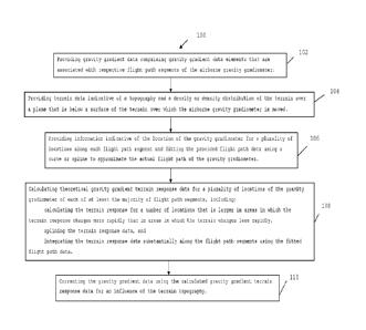
Consequently, the method 100 comprises the initial step of
providing gravity gradient data comprising gravity gradient data
elements (values) that are associated with respective flight
path segments of the airborne gravity gradiometer.
CA 02881673 2015-02-10
WO 2014/047682 PCT/A112013/001096
7
The gravity gradient response is proportional to 1/r3 (r:
distance from the body causing the gravity gradient response to
the gravity gradiometer) and consequently deposits of valuable
material that are located well below the surface 202 of the
terrain 200 often only cause a very small variation in gravity
gradient compared to that arising from topographical changes of
a surface 202 of the terrain 200. Consequently, it is often
desirable to correct measured gravity gradient data for terrain
effects.
Information concerning the topography of the terrain 200 over
which the gravity gradiometer is flown is in this example
provided using Laser Imaging Detection and Ranging (LIDAR) or
other suitable techniques. The method 100 comprises step 104 of
providing such terrain data indicative of the topography of the
terrain 200. Further, step 104 provides a density distribution
of the terrain 200 over a datum that is below the surface 202 of
the terrain 200. The density is usually, but not necessarily,
assumed to be uniform between the datum and the surface 202 of
the terrain 200. The datum typically is a flat plane, but in
very large surveys, this datum may also be a curved surface e.g.
the Geoid or mean sea level.
As mentioned above, the gravity gradient is detected
continuously, but integrated over finite intervals. In this
example, the intervals correspond to flight path segments along
which the gravity gradiometer is moved during one second. The
lengths of the flight path segments dependent on a velocity of
the aircraft. For example, the lengths may be of the order of
50 to 60 metres.
The method 100 comprises step 106 of providing detailed
information concerning the flight path 203 of the gravity
gradiometer. For example, this information may be provided
using a global positioning system (GPS) at suitable time
intervals, such as 0.1 to 1 second. Flight path data is provided
CA 02881673 2015-02-10
WO 2014/047682 PCT/A112013/001096
8
in three dimensions and for a plurality of locations along each
flight path segment (such as 2, 5, 10 or any other number of
locations). The flight path data is then fitted using a curve or
spline to approximate the actual flight path of the gravity
gradiometer.
Using the provided data regarding the terrain 200 and the flight
path 203, theoretical gravity gradient terrain response data are
then calculated for a plurality of positions along each of at
least the majority of the flight path segments. The number of
locations for which the theoretical gravity gradient response is
calculated may or may not be the same as the number of locations
for which the flight path data is provided for each flight path
segment. Figure 2 (a) indicates these locations in the form of
vertical lines along the flight path 203. Generally, the
theoretical gravity gradient response data may be calculated for
any number of locations along the flight path segments, such as
two, five or ten or more locations along each flight path
segment. In the present example the theoretical gravity gradient
response is calculated for more locations at regions in which
the terrain surface 202 changes more rapidly than for locations
at regions at which the terrain surface 202 changes less
rapidly, which will be described in further detail below.
Step 108 of the method 100 comprises calculating the theoretical
gravity gradient terrain response data for a plurality of
locations along each of the majority of the flight path segments
and the calculated data are visualised in the form of dots 204
in Figure 2 (b). These values of the theoretical gravity
gradient terrain response are spline-fitted (spline 208) and
then integrated substantially along the flight path segments and
using the curve or spline fitting flight path data. As mentioned
above, a uniform density is assigned for the region between the
terrain surface and the datum. The theoretical gravity gradient
terrain response is dependent on topographical changes along the
CA 02881673 2015-02-10
WO 2014/047682
PCT/A112013/001096
9
surface 202 of the terrain 200 and may be represented
schematically in terms of the area between datum 209 and the
spline 208 as shown in Figure 2 (b). The straight portions 210
represent terrain response approximations obtained using
conventional point correction methods (one calculated gravity
gradient terrain response element per flight segment), and the
difference between the straight portions 210 and the spline 208
is representative of an improvement of the method in accordance
with an embodiment of the present invention.
Step 110 of the method 100 comprises correcting the gravity
gradient data using the calculated gravity gradient terrain
response data. In this step the calculated gravity gradient
terrain response data (processed in the above-described manner)
for each flight path segment is subtracted from the
corresponding gravity gradient data. Consequently, a variation
of a terrain effect along each flight path segment (provided in
the form of the plurality of calculated gravity gradient
response data along each flight path segment) is taken into
account for correcting the gravity gradient data for terrain
effects, which improves the estimate of terrain effects which,
when removed, enables better detection of small "anomalies" from
deeper sources.
Figure 3 shows plot 302 that illustrates a determined cross-
section (topography) of a terrain surface over which a gravity
gradiometer was flown. Plot 304 illustrates a profile of the
flight path of the airborne gravity gradiometer and each dot
corresponds to a location representative of a length of a
respective flight path segment along which the gravity
gradiometer was moved during the period of 1 second
(approximately 60 metres in this example). In order to choose
an optimum degree of sub sampling of the flight path, without
adding unnecessary additional detail, an initial estimate is
made of the "rate of change" of the terrain component of the
CA 02881673 2015-02-10
WO 2014/047682 PCT/A112013/001096
total gravity gradient signal, and this is used to enable an
"adaptive" sampling regime, which relates to the above
description of the embodiment visualised in Figure 2 (b).
Figure 4 shows the plot 302 having an area of interest 402 and
5 the adaptive sampling regime. Dots of plot 404 represent
locations along flight path segments for which the terrain
response is calculated. In order to increase the accuracy, the
terrain response is calculated for more locations at or near
areas at which the terrain response changes more rapidly than at
10 other areas.
Figure 5 shows also the plots 302, 304 and 306 at a scale that
is different to that of Figures 3 and 4. Further, Figure 5
shows plot 509, which illustrates the difference between gravity
gradient data that were corrected using one gravity gradient
response data point along each flight path segment (conventional
method) and a method in accordance with an embodiment of the
present invention which uses a plurality of gravity gradient
response data points along each flight path segment (in this
example 12). In this example, which uses relatively gentle
terrain, the difference may be as much as 5 Eo and even larger
differences are expected in areas of steeper terrain.
The terrain corrected gravity gradient data may then be plotted
as a 2D grid map or further processed in various ways, including
inversion modelling, to facilitate interpretation and the
location of deposits of valuable material below the terrain
surface.
It is to be appreciated that various variations of the described
embodiments are possible. For example, the gravity gradiometer
may be flown at any suitable speed and the gravity gradiometer
may take measurements during any suitable time intervals.
Further, a suitable number of gravity gradient terrain response
data points may be taken into account for correcting the gravity
CA 02881673 2015-02-10
WO 2014/047682 PCT/A112013/001096
11
gradient data for the terrain effects.
The reference that is being made to prior patent documents is
not an admission that the disclosure of these documents is part
of the common general knowledge of a skilled person in Australia
or any other country.