Note: Descriptions are shown in the official language in which they were submitted.
CA 02882663 2015-02-19
WO 2014/031094
PCT/US2012/051568
1
METHODS AND SYSTEMS OF INCORPORATING PSEUDO-SURFACE
PICK LOCATIONS IN SEISMIC VELOCITY MODELS
BACKGROUND
[0001] Advances in horizontal drilling have increased the ability to
economically
recover hydrocarbons from hydrocarbon bearing formations. However,
placement of the horizontal borehole (also known as a lateral) requires
particular
accuracy. For example, a shale formation may be several thousand feet below
the surface, and the shale formation itself may be on the order of 1000 feet
thick.
Within the illustrative 1000 feet of thickness only a few relatively thin
zones, each
zone on the order of tens of feet thick, may be suitable locations for
placement of
the lateral and extraction of hydrocarbons (i.e., target zones). Outside the
target
zones, some hydrocarbon extraction may be possible, but such extraction is in
most cases not economically viable.
[0002] Moreover, physical phenomena such as faulting and differential
compaction may make the true vertical depth of a target zones different as a
function of horizontal location within the hydrocarbon bearing formation. Even
if
one is able to identify at a particular location a target zone for lateral
placement
(e.g., at a survey borehole), the precise depth of the target zone may change
as a
function of distance from the particular location.
[0003] Thus, any advance which results in better steering of horizontal
boreholes would provide a competitive advantage.
BRIEF DESCRIPTION OF THE DRAWINGS
[0004] For a detailed description of exemplary embodiments of the
invention, reference will now be made to the accompanying drawings in
which:
[0005] Figure 1 shows a perspective cutaway view of a portion of hydrocarbon
bearing formation, and in accordance with at least some embodiments;
[0006] Figure 2 shows a user interface in accordance with at least some
embodiments;
CA 02882663 2015-02-19
WO 2014/031094
PCT/US2012/051568
2
[0007] Figure 3 shows a user interface in accordance with at least some
embodiments;
[0008] Figure 4 shows a user interface in accordance with at least some
embodiments;
[0009] Figure 5 shows a user interface in accordance with at least some
embodiments;
[0010] Figure 6 shows a method in accordance with at least some
embodiments; and
[0011] Figure 7 shows a computer system in accordance with at least some
embodiments.
NOTATION AND NOMENCLATURE
[0012] Certain terms are used throughout the following description and claims
to
refer to particular system components. As one skilled in the art will
appreciate,
different companies may refer to a component by different names. This
document does not intend to distinguish between components that differ in name
but not function.
[0013] In the following discussion and in the claims, the terms "including"
and
"comprising" are used in an open-ended fashion, and thus should be interpreted
to mean "including, but not limited to... ." Also, the terms "couple" or
"couples"
are intended to mean either an indirect, direct, optical or wireless
electrical
connection. Thus, if a first device couples to a second device, that
connection
may be through a direct connection or through an indirect connection via other
devices and connections.
[0014] "Measured log" shall mean a series of values where each value is
indicative of a measured parameter of a rock formation at a position along a
borehole. Measured log shall include not only an entire measured log, but also
portions of a measured log less than the entire measured log.
[0015] "Predicted log" shall mean a series of values where each value is
indicative of a predicted parameter of a rock formation at a position along a
borehole. Predicted log shall include a log created by one more actual logs or
may include a measured log determined at a different position within the same
CA 02882663 2015-02-19
WO 2014/031094
PCT/US2012/051568
3
borehole. Predicted log shall include not only an entire predicted log, but
also
portions of a predicted log less than the entire predicted log.
[0016] "Borehole" shall mean a hole drilled into the Earth's crust used
directly or
indirectly for the exploration or extraction of natural resources, such as
oil, natural
gas, or water.
[0017] "Horizontal borehole" shall mean a borehole where at least a portion of
the borehole has a deviation from the vertical orientation that exceeds at
least 20
degrees. The fact that a borehole may initially be drilled with a vertical
orientation, and the fact that the horizontal borehole may not be exactly
horizontal
in relation to a face of the earth or a horizontal plane, shall not obviate
the status
as a horizontal borehole.
[0018] "Drag-and-drop" shall mean that a feature on a display device is
selected
responsive to commands received from a pointing device, and while selected,
the
position of the feature is changed responsive to commands received.
[0019]"Surface pick location" shall mean a point at which a borehole actually
penetrates a physical location corresponding to a modeled subsurface horizon.
[0020]"Pseudo-surface pick location" shall mean a point at which an indication
is placed within a modeled subsurface horizon based on a borehole, but where
the borehole does not penetrate the physical depth/location corresponding to
the point within the modeled subsurface horizon.
[0021]"Non-linear" with respect to a modeled subsurface horizon, shall mean
that the subsurface horizon has curvature as opposed to representing a
straight
line. Non-linear shall not refer to discontinuities (e.g., step functions) in
the
modeled subsurface horizon.
[0022]"Real-time" in relation to performing a task related to a seismic
velocity
model or a modeled horizon shall mean completing the task with in one minute
or less from a trigger event.
[0023]"Animating" or "animation" in relation to operations associated with a
display device shall mean that changes in a plotted object are presented at 15
frames per second or greater.
CA 02882663 2015-02-19
_
WO 2014/031094
PCT/US2012/051568
4
DETAILED DESCRIPTION
[0024] The following discussion is directed to various embodiments of the
invention. Although one or more of these embodiments may be preferred, the
embodiments disclosed should not be interpreted, or otherwise used, as
limiting
the scope of the disclosure, including the claims. In addition, one skilled in
the art
will understand that the following description has broad application, and the
discussion of any embodiment is meant only to be exemplary of that embodiment,
and not intended to communicate that the scope of the disclosure, including
the
claims, is limited to that embodiment.
[0025] Underground hydrocarbon bearing formations may reside several
thousand feet below the face of the earth, and may be several thousand feet
thick. While an entire formation may be saturated to some extent with
hydrocarbons, hydrocarbons may be economically produced from particular
locations (e.g., near the top of the formation of porous rock, or within
particular
zones of shale formations). The relatively small zones from which hydrocarbons
can be economically produced are referred to herein as target zones.
[0026] Various embodiments are directed to methods and systems of refining
not only modeled surfaces, but also by refining seismic velocity models such
that
seismic depth volumes better indicate the locations of various subsurface
horizons of interest. In order to more fully describe the methods and system,
the
specification first turns to a high level description to orient the reader.
[0027] Figure 1 shows a perspective cutaway view of a portion of the earth's
crust. In particular, Figure 1 shows the face 100 of the earth (referred to as
the
face rather than the "surface" as "surface" has a particular meaning discussed
more below). Below the face 100 is a portion of a hydrocarbon bearing
formation
102 (shown in solid lines). Though the materials that make up hydrocarbon
bearing formation 102 may initially be deposited in horizontal layers,
differential
compaction and faulting may result in dip. In particular, dashed line 104 may
illustrate two edges of a horizontal plane, and thus the illustrative
hydrocarbon
bearing formation 102 dips downwardly in the direction of the viewer in Figure
1.
[0028] Figure 1 also shows several boreholes drilled into the hydrocarbon
bearing formation. For example, borehole 106 is shown to be a vertically
oriented
CA 02882663 2015-02-19
WO 2014/031094
PCT/US2012/051568
borehole that extends through the hydrocarbon bearing formation 102. Borehole
106 is associated with wellhead 108 to illustrate that borehole 106 has been
previously drilled, and in some situations borehole 106 may have a casing
therein. Likewise, Figure 1 illustrates borehole 110 as a vertically oriented
borehole that extends through the hydrocarbon bearing formation 102. Borehole
110 is associated with wellhead 112 to illustrate that borehole 110 has been
previously drilled, and in some situations may have a casing therein. In the
industry, boreholes 106 and 110 may be referred to as "offset wells" or "type
wells" when discussed in relation to horizontal boreholes which are planned or
currently being drilled, and thus will be referred herein as offset wells 106
and 110. While offset wells 106 and 110 are shown as vertically oriented and
extending completely through the hydrocarbon bearing formation 102 so as to be
distinguishable from the proposed horizontal borehole (discussed more below),
offset wells need not necessarily be vertically oriented, or extend through
the
hydrocarbon bearing formation. Stated otherwise,, offset wells may be any type
of
borehole, including horizontal boreholes.
[0029] Information useful for planning a trajectory of a horizontal borehole
may
be determined from the offset wells 106 and 110. For example, by way of offset
well 106, the vertical depth 114 of the top of the hydrocarbon bearing
formation 102 at the location of the offset well 106 may be accurately
measured.
Likewise, by way of offset well 110, the vertical depth 116 at the top of the
hydrocarbon bearing formation 102 at the location of offset well 110 may be
accurately measured. Moreover, a plurality of well logs may be taken within
offset wells 106 and 110. For example, the offset wells may be logged while
drilling, may be logged during the overall drilling process but with the drill
string
removed (e.g., logged by way of wireline logging devices), and/or may be
logged
after drilling has completed and a casing has been cemented therein. The well
logs may provide a host of information about the hydrocarbon bearing
formation 102. For example, the well logs taken in the offset wells may
provide
identifying information (i.e., marker information) for various depths within
the
hydrocarbon bearing formation 102. That is, the marker information may be
CA 02882663 2015-02-19
WO 2014/031094
PCT/US2012/051568
6
based on any measurable property of the hydrocarbon bearing formation, such as
natural gamma radiation or electrical resistivity.
[0030] In addition to measurements gathered from offset wells 106 and 110, a
seismic survey may be conducted to provide seismic mapping of the hydrocarbon
bearing formation 102. In order to conduct a seismic survey, a seismic source
device, such as the explosion of dynamite or a thumper truck, generates
seismic
waves which travel into the subsurface layers, including into hydrocarbon
bearing
formation 102. The seismic waves partially reflect off the subsurface horizons
of
each subsurface layer the seismic waves encounter. The seismic waves
reflected back towards the earth's face are received by an array of seismic
receivers, such as geophones, and arrival times and amplitudes are recorded.
The set of arrival times and amplitudes may be referred to as a seismic
time/amplitude volume. A seismic velocity model, comprised of known or
estimated seismic velocity properties of each subsurface layer, is applied to
the
seismic time/amplitude volume which creates a seismic amplitude/depth volume
(hereafter just "seismic depth volume"). In other words, the seismic depth
volume
is a seismic volume represented by an array of amplitude/depth information. It
is
to be understood that the seismic time/amplitude volume, the seismic velocity
model, and the seismic depth volume are separate data structures. As better
information regarding the seismic velocity is determined, the seismic velocity
model may be updated, and a new and/or updated seismic depth volume may be
created. The seismic depth volume, as describe in further detail below,
provides
the geologist information to aid in the placement of a horizontal boreholes.
[0031] For purposes of further discussion, it is assumed that a target zone
118
of interest is a location just under the top of the hydrocarbon bearing
formation 102; however, target zones need not be near the top of the
hydrocarbon bearing formation. For example, in shale formations the target
zone
may reside at any depth within the formation. Once the target zone in relation
to
offset wells 106 and 110 is identified, and also based on the seismic depth
volume, one or more "modeled" surfaces are created. Modeled surfaces shall be
understood to be a mathematical creation ¨ fictional line or surface ¨ and do
not
necessarily have any true physical components.
CA 02882663 2015-02-19
WO 2014/031094
PCT/US2012/051568
7
[0032] In the illustrative case of Figure 1, an upper modeled surface 120 may
be
created which represents the assumed top of the hydrocarbon bearing
formation 102. It may be known in advance from the seismic depth volume that
the hydrocarbon bearing formation 102 dips in the direction of the viewer in
Figure 1, but because there is not an offset well at the point in the
hydrocarbon
bearing formation 102 closest to the viewer, the magnitude of the dip may not
be
precisely known. For this reason, the initial upper modeled surface 120
(defined
in part by dashed-dot-dot-dash lines 121) may be initially assumed to have a
slight dip, but as illustrated in Figure 1, the dip may not necessarily match
that of
the actual formation 102.
[0033] In some cases, a lower modeled surface 122 may be created which
identifies the assumed lower boundary of the target zone 118. In the
illustrative
case of Figure 1, the lower modeled surface is defined in part by dash-dot-dot-
dash lines 124. Before proceeding, it should be understood that having both an
upper and a lower modeled surface is merely illustrative. The correlations
between the measured log and predicted log discussed below may take place in
the presence of a single modeled surface, which could be the upper modeled
surface in some cases, or just the lower modeled surface.
[0034] Based on the modeled surfaces 120 and 122, a plan for a horizontal
borehole is made (the proposed trajectory or proposed path 125 is showed by
dashed-dot-dash line), with the proposed path of the horizontal borehole to
reside
just below modeled surface 120 (or in cases where two modeled surfaces are
used, between the modeled surfaces). In the illustrative case of Figure 1,
because of inaccuracies in the seismic velocity model, if the horizontal
borehole is
drilled exactly along the proposed path 125, the distal end of the horizontal
borehole will exit the top of the hydrocarbon bearing formation. As discussed
more below, however, as the horizontal borehole is being drilled, the relative
location within hydrocarbon bearing formation 120 can be determined (based on
the marker information), and the direction of the horizontal borehole
corrected to
take into account the actual dip of the information.
[0035] After the proposed path 125 planning has been complete, drilling of a
horizontal borehole along the proposed path 125 begins, and the drill string
used
CA 02882663 2015-02-19
WO 2014/031094
PCT/US2012/051568
8
to create the horizontal borehole may have one or more measuring-while-
drilling
("MWD") tools (e.g., inclination sensor, directional sensor) to facilitate
measuring
actual physical placement with respect to modeled surfaces 120 and 122. That
is to say, knowing the vertical depth of the modeled surfaces 120 and 122 at
any
particular location, and using information gathered by the MWD tools, the
horizontal borehole drilled along proposed path 125 can be somewhat accurately
placed in relation to the modeled surfaces 120 and 122. Physical placement
based on knowledge of the direction and depth of the horizontal borehole as
the
horizontal borehole is being drilled is not a perfect science, however, and is
subject to measurement inaccuracies, undershoot, and overshoot. Thus, some
deviation from the proposed path 125 is to be expected in most situations.
[0036] The drill string used to create the horizontal borehole along the
proposed
path 125 may also comprise one more logging-while-drilling ("LWD") tools which
create one or more measured logs of formation parameters, the measured logs
created contemporaneously with the drilling. While a variety of logging tools
may
be used, in order to correlate or compare the measured logs to the marker
information derived from the offset wells, at least one of the logging tools
creates
a measured log from which marker information is indicated or can be derived
(e.g., a natural gamma tool). At various times, after the horizontal borehole
has
entered the hydrocarbon bearing formation, the measured log is compared to a
predicted log (the predicted log created, at least in part, by the marker
information
measured within the offset wells). The comparison of the measured log to the
predicted log is used to make a determination as to where in the formation the
horizontal borehole actually resides and to make corrections to the modeled
surfaces (if needed), to make corrections to the seismic velocity model (if
needed), and to make corrections to the drilling direction of the horizontal
borehole (if needed). Comparing the measured log to the predicted log may be
referred to as correlation of the measured log to the predicted log. The
predicted
log and the correlating are discussed more with respect to Figure 2.
[0037] Figure 2 shows a user interface through which a user can interact with
a
program to correlate a measured log and a predicted log, to refine the
location of
a modeled surface, and/or to refine a seismic velocity model. The user
interface
CA 02882663 2015-02-19
WO 2014/031094
PCT/US2012/051568
9
may be displayed on a display device of a computer system. In particular, the
illustrative user interface 200 comprises an upper window or upper pane 202,
and
a lower pane 204. The lower pane 204 may be referred to as a measured and
predicted log window, and the upper pane 202 may be referred to as a borehole
and surface pane. Within the background of illustrative upper pane 202 is
plotted
a two-dimensional cross-sectional view of seismic horizons 260 and 262 from a
seismic depth volume. In this example embodiment, only two horizons are
shown, although any number of horizons and/or seismic attributes may be
plotted. In addition, within upper pane 202 is plotted a two-dimensional view
of
the upper modeled surface 120 and the lowered modeled surface 122 (e.g., the
view taken along lines 2-2 of Figure 1). That is, in the two-dimensional view
of
the upper pane 202 of Figure 2, the upper modeled surface 120 and the lower
modeled surface 122 appear as line segments so as not to unduly complicate the
figure. Also plotted in the illustrative upper pane 202 is the actual
trajectory of the
horizontal borehole 206 (the proposed path is not shown), which also appears
as
a line segment. The portion of the seismic depth model 264 (comprising
horizons
260 and 262), the upper modeled surface 120, lower modeled surface 122, and
the trajectory of the horizontal borehole 206 are plotted against the abscissa
axis
208 illustratively being a distance, and an ordinate axis 210 being depth
(with
illustrative depth 6000 feet at the top of the pane 202, and 6350 feet at the
bottom
of the pane).
[0038] In the example case plotted in upper pane 202, the horizontal
borehole 206 penetrates the upper modeled surface 120 at point 212, and also
penetrates the lower modeled surface 122 at point 214. The horizontal
borehole 206 thus illustrates an overshot in trying to place the borehole 206
in the
target zone 118. Once the horizontal borehole 206 enters again the target
zone 118 between the upper modeled surface 120 and the lower modeled
surface 122, the distal end of the horizontal borehole 206 illustratively
exits the
target zone 118. The locations where the borehole 206 penetrates a modeled
surface may be referred to as surface picks. That is, a surface pick location
is a
location at which a borehole actually penetrates a physical location
corresponding
,
CA 02882663 2015-02-19
WO 2014/031094
PCT/US2012/051568
to a modeled subsurface horizon. The depth of the modeled surface is thus
known precisely at the surface pick locations.
[0039] Within the illustrative lower pane 204 are plotted values of a measured
log, as well as values of a predicted log, with the plotted values appearing
as line
segments. The measured log and predicted log are plotted against the abscissa
axis 208 illustratively being a distance, and an ordinate axis 218
illustratively
being magnitude of the values of the logs. Thus, both the measured log and the
predicted log are plotted against the same ordinate and abscissa axis. A
measured log is a series of values of actually measured or derived formation
parameters (e.g., values measured by a LWD tool within the horizontal
borehole 206). Any suitable formatiofl parameter may be measured and used for
the measured log, but in some embodiments, the measured parameter may be
natural gamma radiation or electrical resistivity.
[0040] The predicted log, by contrast, is a modeled or synthetic log created
from
values of the measured parameter at offset wells 106 and 110, taking into
account dip of the hydrocarbon bearing formation. Stated otherwise, each value
of the predicted log is a valued expected to be measured at each particular
location along the trajectory of the horizontal borehole 206 taking into
account the
distance the borehole 206 is above or below a geological feature represented
by
the modeled surfaces. However, as discussed above, the dip of the portions of
the modeled surfaces between offset wells may not match the actual dip of the
hydrocarbon bearing formation 102 because of inaccuracies in the seismic
velocity model. More particularly, the dip of the modeled surfaces may not
match
the actual dip of the formation at each position (or depth) because of
cumulative
difference in dip along the length of the planned borehole, which, in
combination
'carry' the actual depth to deeper or shallower positions as compared to the
model surfaces. When the cumulative dips of the modeled surface accurately
matches the cumulative dips of the hydrocarbon bearing formation 102, the
measured log and predicted log should (in theory) fully overlap. Measurement
inaccuracies, and inaccuracies in interpolation (due to structural complexity)
may
cause the data to not precisely align point-for-point; however, major features
of
the measured log and predicted log should substantially align when the
CA 02882663 2015-02-19
WO 2014/031094
PCT/US2012/051568
11
cumulative dips of the modeled surfaces accurately matches the actual
cumulative dips of the hydrocarbon bearing formation.
[0041] With the various issues regarding overlap of the measured log and
predicted log in mind, reference is again made to the lower pane 204 of the
user
interface 200 of Figure 2. For purposes of explanation, in Figure 2, portions
of
the measured log and predicted log have already been correlated. In
particular,
portion 230 and portion 232 have been correlated, and thus the measured log
and predicted log overlap in these regions (the overlap shown by the heavy,
dark
line). When the measured log and predicted log are correlated, a fixed point
or
marker may then be created in one or both of the modeled surfaces. The fixed
point represents a location (e.g., an X, Y, Z location in Cartesian Space)
where
the modeled surface is presumed to accurately match the geological boundary of
interest, and thus future adjustments to the modeled surface do not affect or
change at the fixed point. Three illustrative fixed points are shown in the
upper
pane 202 ¨ fixed points 240, 242, and 244. However, in portion 234, the
measured log 236 (solid line) and predicted log 238 (dashed line) do not
overlap
(i.e., are not correlated). Thus, within the portion 234, the measured log 236
and
predicted log 238 need to be correlated.
[0042] Correlation in accordance with various embodiments involves selecting
an inflection point in the predicted log 238. The inflection point selected
may be a
maxima, a minima, or just an inflection point between a set of maxima and
minima. For purposes of explanation, consider that a user (e.g., a geologist)
would like to select the inflection point 250. Selection of the inflection
point may
take many forms. In some embodiments, a pointing attribute 252 (illustratively
shown as an arrow) may be moved about the display device responsive to a
pointing device (e.g., mouse, or touch-screen overlaying the display device).
Based on the location of the pointing attribute 252 being placed on or near
the
inflection point 250, and possibly other action (e.g., mouse click), the
inflection
point is selected. In the illustration of Figure, 2, the selected inflection
point
represents a value of the predicted log at a particular distance D below the
upper
modeled surface 120 (the correlation between the inflection point 250, upper
modeled surface, and distance D shown in relation to dashed line 254). When
CA 02882663 2015-02-19
WO 2014/031094
PCT/US2012/051568
12
the value of the selected inflection point 250 does not match or overlay the
measured log, such indicates that the local dip of the modeled surface (and
correspondingly the seismic depth volume) does not accurately match the actual
dip of the hydrocarbon bearing formation 102.
[0043] Once a particular inflection point is selected, a correlation may be
made
by moving the inflection point left or right on the screen ¨ that is, shifting
the
horizontal position of the inflection point. At a high level, the user shifts
the
inflection point until a match of the predicted log 238 and measured log 236
is
found. The specification first discusses the visual aspects of shifting the
horizontal location of the inflection point 250 within the lower pane 204, and
then
discusses conceptually the changes to the modeled surfaces and seismic
velocity
model responsive to shifting of the inflection point 250.
[0044] With respect to the visual aspects within the lower pane 204, shifting
the
horizontal position of the inflection point 250 correspondingly shifts the
predicted
log 238. Consider, for example, the portion of the predicted log 238 between
the
inflection point 250 and the portion corresponding to fixed point 242.
Shifting the
infection point 250 in the direction of the fixed point 242 causes the portion
of the
predicted log 238 to contract, with plotted values of the predicted log 238
closer to
the fixed point 242 moving less than plotted values of the predicted log 238
close
to the inflection point. Likewise, shifting the inflection point 250 away from
the
fixed point 242 causes the portion of the predicted log 238 to expand, though
still
with plotted values of the predicted log 238 closer to the fixed point 242
moving
less than plotted values of the predicted log 238 close to the inflection
point. The
portion of the predicted log between the inflection point 250 and fixed point
244
expands and compresses oppositely in this example. In the illustrative case of
Figure 2, portion 234 of the predicted log 238 that remains uncorrelated
resides
between two fixed points (fixed points 242 and 244), and thus movement of the
inflection point 250 causes changes to the portion 234 between fixed points
242
and 244, but portions 230 and 232 remain unchanged.
[0045] In some embodiments, changes to the predicted log responsive to the
shifting of the inflection point 250 are animated. That is, the display device
on
which the user interface 200 is displayed is updated at about 15 frames a
second
,
CA 02882663 2015-02-19
WO 2014/031094
PCT/US2012/051568
13
or greater such that the compression and/or expansion of the predicted log 238
responsive to movement of the inflection point appears to be a smooth change.
In other cases, particularly situations where the frame rate is limited or
where the
processing power of the underlying computer system is limited, the predicted
log 238 may not be redrawn until movement of the inflection point stops of the
inflection points is deselected (i.e., dropped in the drag-and-drop
operation).
[0046] The visual aspects of the changes in the predicted log 238 responsive
to
horizontally shifting the inflection point 250 are actually a consequence of
changing the dip of one or both of the modeled surfaces 120 and 122. Still
referring to Figure 2, and particularly the upper frame 202, each value or
point on
the predicted log represents a value related to the distance or depth D. When
the
inflection point 250 does not overlay or correspond to the measured log 236,
such
a lack of correspondence means that the dip of the modeled surface may not
match that of the actual formation. Shifting of the inflection point thus can
be
thought of as changing the dip of the modeled surface 120 until the predicted
log 238 overlays or matches the measured log 236. In these embodiments, the
distance or depth D remains constant, but is shifted responsive to shifting of
the
inflection point. In other words, the distance between representation of D
remains
constant, but is shifted responsive to shifting of the inflection point.
Stated
otherwise again, the distance between representation of the horizontal
borehole 206 and the modeled surface (here the upper modeled surface 120) at
the horizontal location of the inflection point 250 remains constant as the
inflection point 250 is shifted (in the lower pane 204). The shifting and
constant
depth D results in changes in the dip of the modeled surface, and
corresponding
changes in the predicted log.
[0047] Figure 3 shows a view of the user interface 200 similar to that of
Figure 2, but illustratively shows the inflection point 250 shifted to the
left from
that of Figure 2. Shifting the inflection point 250 to the left, but holding
the
depth D constant, results in changes in dip of the upper modeled surface 120.
In
particular, portion 300 of the modeled surface 120 dips from fixed point 242
to the
corresponding location of the inflection point 250 (correlated by dashed line
254),
and the dip has greater magnitude than that of Figure 2. Likewise for portion
302
CA 02882663 2015-02-19
WO 2014/031094
PCT/US2012/051568
14
of the upper modeled surface, portion 302 of the modeled surface 120 dips from
fixed point 244 to the corresponding location of the inflection point 250, and
the
dip has greater magnitude that that of Figure 2. Figure 3 also illustrates
that in
changing the dip of the upper modeled surface 120, the corresponding portions
of
the predicted log change. Portion 304 has the appearance of contraction in
relation to the corresponding portion of Figure 2, while portion 306 has the
appearance of expansion in relation to the corresponding portion in Figure 2.
In
some cases, however, the predicted log 238 in the lower pane 204 is
recalculated
with each new dip adjustment shown in the upper pane 202, and the
recalculation
gives the appearance of expansion and contraction of the predicted log 238.
[0048] Figure 4, however, shows a view of the user interface 200 similar to
that
of Figure 2, but illustratively shows the inflection point 250 shifted to the
right from
that of Figure 2. In particular, for portion 400 of the modeled surface 120,
the dip
has decreased from fixed point 242 to the corresponding location of the
inflection
point 250 (correlated by dashed line 254). Likewise, for portion 402 of the
upper
modeled surface, for potion 402 of the modeled surface 120 the dip has
increased from fixed point 244 to the corresponding portions of the predicted
log 238 in the lower pan 204. The changes in the predicted log 238 caused by
the illustrative changes in the dip make the predicted log 238 and measured
log 236 overlay, and thus correlate. Given the substantial correlation, the
user
may "drop" the inflection point at the shifted location, thus creating a new
fixed
point 404 within the modeled surface 120.
[0049] A few points before proceeding: firstly, notice how the illustrative
fixed
point 404 modifies the modeled surface 120. In particular, initially at least,
inserting a fixed point into the modeled surface results in straight-line
changes
between points ¨ a straight line connects fixed point 242 and fixed point 404,
and
a straight line connects fixed point 404 and fixed point 244. Further,
initially at
least, the changes implemented to the modeled surface 120 are bounded by fixed
points ¨ the new fixed point 404 does not affect the modeled surface beyond
(here, to the right of) fixed point 244. Further notice that the new fixed
point 404
and corresponding modeled surface 120 no longer match the horizon 260 of the
seismic depth volume 264.
CA 02882663 2015-02-19
WO 2014/031094
PCT/US2012/051568
[0050] As discussed previously, modeled surfaces 120 and 122 are created, at
least in part, by data from the seismic depth volume 264 (and in particular
horizons 260 and 262 within the seismic depth volume 264). When a fixed point
is placed in a modeled surface that changes the dip of the modeled surface,
the
change is indicative of inaccuracies in the seismic velocity model used to
create
the seismic depth volume. Thus, in accordance with various embodiments, once
a fixed point is placed in a modeled surface, the computer system updates the
seismic velocity model, recalculates the seismic depth volume so that the
corresponding horizon in the seismic depth model is corrected, and in some
cases recalculates the modeled surface based on the updated horizon or
horizons. Stated otherwise, a new fixed point in the modeled surface is
treated
similarly to a surface pick from the standpoint of location of the modeled
surface
(and thus the fixed point may be referred to as a pseudo-surface pick). The
pseudo-surface pick is a time/depth pair which uses the depth measured in the
well and the time of the seismic horizon. Based on the pseudo-surface pick,
other time/depth pairs in the seismic velocity model may be updated, and/or
additional time/depth pairs added to the seismic velocity model.
[0051] Figure 5 shows a view of the user interface 200 similar to that of
Figure 4, but illustratively shows recalculated seismic depth volume and
recalculated modeled surfaces. In particular, in the view of Figure 5, the
computer system has modified at least a portion of the seismic velocity model
based on the pseudo-surface pick, recalculated the seismic depth volume based
on the seismic velocity model, and plotted modified horizons 260 and 262.
Notice
the illustrative dipping portion 500 in the horizon 260 and corresponding
dipping
portion 502 in the horizon 502. Further still, in the view of Figure 5, the
computer
system has recalculated the modeled surfaces 120 and 122 based on the
updated horizons 260 and 262. In particular, the modeled surface 120 now more
closely matches the horizon 260, and also the modeled surface 120 is no longer
constrained to straight lines between fixed points. That is, modeled surface
120
now has non-linear or curved portions 504 corresponding to the horizon 260.
For
purposes of illustration, the straight line portions of the modeled surface
120 prior
to recalculation are shown in dashed lines.
CA 02882663 2015-02-19
WO 2014/031094
PCT/US2012/051568
16
[0052] Moreover, Figure 5 illustrates that changes to the seismic velocity
model
may also change portions of the modeled surfaces beyond fixed points. For
example, in zone 506, residing beyond the fixed point 244, the updated seismic
depth volume may be used to recalculate the modeled surface 120. The
recalculated modeled surface 120 beyond the fixed point 244 is shown in as a
solid line, while the previous version of the modeled surface 120 beyond the
fixed
point 244 is shown as a dashed line to illustrate the change in this
particular
example. Stated otherwise, refining the seismic velocity model further
provides
information related to the modeled surfaces beyond the fixed points. With the
new
information regarding the modeled surfaces, the drilling direction of the
borehole
206 may be modified accordingly, in this illustrative case to turn to again
reside
between the modeled surfaces 120 and 122.
[0053] In some embodiments, changes to the modeled surfaces responsive to
the shifting of the inflection point 250 are animated. That is, the display
device on
which the user interface 200 is displayed is updated at about 15 frames a
second
or greater such that the changes to the modeled surfaces responsive to
movement of the inflection point appear to be smooth changes. In other cases,
particularly situations where the frame rate is limited or where the
processing
power of the underlying computer system is limited, the modeled surfaces may
not be redrawn until movement of the inflection point stops or the inflection
point
is deselected (i.e., dropped in the drag-and-drop operation).
[0054] Further still, in some embodiments changes to the seismic velocity
model
(and thus the seismic depth volume) responsive to the placing of fixed points
within the modeled surfaces are made in real-time. That is, the display device
on
which the portion of the seismic depth volume is displayed is updated in real-
time
when a new fixed point is placed in a modeled surface. It follows that
recalculating the modeled surface based on the updated seismic velocity model
takes place in real-time, and in some cases the changes are animated. In other
cases, particularly situations where the size of the seismic depth volume is
large
and/or where the processing power of the underlying computer system is
limited,
the updated seismic depth volume may be redrawn at a later time, such as after
several fixed points have been located.
CA 02882663 2015-02-19
WO 2014/031094
PCT/US2012/051568
17
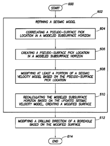
[0055] Figure 6 shows a method in accordance with at least some
embodiments, and some of which may be implemented by way of computer
instructions. In particular, the method starts (block 600) and comprises
refining a
seismic model (block 602). In some cases, refining may comprise correlating a
predicted log to a measured log (block 604). The method may then comprise
creating a pseudo-surface pick location in a modeled subsurface horizon (block
606); modifying at least a portion of the seismic velocity used in the seismic
velocity model based on the pseudo-surface pick location (block 608), and then
recalculating the modeled subsurface horizon based on the seismic velocity
model, creating a modified surface (block 610). After the seismic model has
been
refined, the method moves to modifying the drilling direction of a borehole
based
on the modified surface (block 612). Thereafter, the method ends (block 614),
possibly to be restarted.
[0056] Figure 7 illustrates a computer system 700 in accordance with at least
some embodiments. Any or all of the embodiments that involve use of a user
interface, or a computer system to perform calculations, may be implemented on
a computer system such as that shown in Figure 7. In particular, computer
system 700 comprises a main processor 710 coupled to a main memory array
712, and various other peripheral computer system components, through
integrated host bridge 714. The main processor 710 may be a single processor
core device, or a processor implementing multiple processor cores.
Furthermore,
computer system 700 may implement multiple main processors 710. The main
processor 710 couples to the host bridge 714 by way of a host bus 716, or the
host bridge 714 may be integrated into the main processor 710. Thus, the
computer system 700 may implement other bus configurations or bus-bridges in
additional to, or in place of, those shown in Figure 7.
[0057] The main memory 712 couples to the host bridge 714 through a memory
bus 718. Thus, the host bridge 714 comprises a memory control unit that
controls
transactions to the main memory 712 by asserting control signals for memory
accesses. In other embodiments, the main processor 710 directly implements a
memory control unit, and the main memory 712 may couple directly to the main
processor 710. The main memory 712 functions as the working memory for the
CA 02882663 2015-02-19
WO 2014/031094
PCT/US2012/051568
18
main processor 710 and comprises a memory device or array of memory devices
in which programs, instructions and data are stored. The main memory 712 may
comprise any suitable type of memory such as dynamic random access memory
(DRAM) or any of the various types of DRAM devices such as synchronous
DRAM (SDRAM), extended data output DRAM (EDODRAM), or Rambus DRAM
(RDRAM). The main memory 712 is an example of a non-transitory computer-
readable medium storing programs and instructions, and other examples are disk
drives and flash memory devices.
[0058] The illustrative computer system 700 also comprises a second
bridge 728 that bridges the primary expansion bus 726 to various secondary
expansion buses, such as a low pin count (LPC) bus 730 and peripheral
components interconnect (PCI) bus 732. Various other secondary expansion
buses may be supported by the bridge device 728.
[0059] Firmware hub 736 couples to the bridge device 728 by way of the LPC
bus 730. The firmware hub 736 comprises read-only memory (ROM) which
contains software programs executable by the main processor 710. The software
programs comprise programs executed during and just after power on self-tests
(POST) procedures as well as memory reference code. The POST procedures
and memory reference code perform various functions within the computer
system before control of the computer system is turned over to the operating
system. The computer system 700 further comprises a network interface card
(NIC) 738 illustratively coupled to the PCI bus 732. The NIC 738 acts as to
couple the computer system 700 to a communication network, such the Internet.
[0060] Still referring to Figure 7, computer system 700 may further comprise a
super input/output (I/O) controller 740 coupled to the bridge 728 by way of
the
LPC bus 730. The Super I/O controller 740 controls many computer system
functions, for example interfacing with various input and output devices such
as a
keyboard 742, a pointing device 744 (e.g., mouse), a pointing device in the
form
of a game controller 746, various serial ports, floppy drives and disk drives.
The
super I/O controller 740 is often referred to as "super" because of the many
I/O
functions it performs.
CA 02882663 2015-02-19
WO 2014/031094
PCT/US2012/051568
19
[0061] The computer system 700 may further comprise a graphics processing
unit (GPU) 750 coupled to the host bridge 714 by way of bus 752, such as a PCI
Express (PCI-E) bus or Advanced Graphics Processing (AGP) bus. Other bus
systems, including after-developed bus systems, may be equivalently used.
Moreover, the graphics processing unit 750 may alternatively couple to the
primary expansion bus 726, or one of the secondary expansion buses (e.g., PCI
bus 732). The graphics processing unit 750 couples to a display device 654
which may comprise any suitable electronic display device upon which any image
or text can be plotted and/or displayed. The graphics processing unit 750 may
comprise an onboard processor 756, as well as onboard memory 758. The
processor 756 may thus perform graphics processing, as commanded by the
main processor 710. Moreover, the memory 758 may be significant, on the order
of several hundred megabytes or more. Thus, once commanded by the main
processor 710, the graphics processing unit 750 may perform significant
calculations regarding graphics to be displayed on the display device, and
ultimately display such graphics, without further input or assistance of the
main
processor 710.
[0062] In the specification and claims, certain components may be described in
terms of algorithms and/or steps performed by a software application that may
be
provided on a non-transitory storage medium (i.e., other than a carrier wave
or a
signal propagating along a conductor). The various embodiments also relate to
a
system for performing various steps and operations as described herein. This
system may be a specially-constructed device such as an electronic device, or
it
may include one or more general-purpose computers that can follow software
instructions to perform the steps described herein. Multiple computers can be
networked to perform such functions. Software instructions may be stored in
any
computer readable storage medium, such as for example, magnetic or optical
disks, cards, memory, and the like.
[0063] It is noted that while theoretically possible to perform some or all
the
calculations, simulations, and/or modeling by a human using only pencil and
paper, the time measurements for human-based performance of such tasks may
range from man-days to man-years, if not more. Thus, this paragraph shall
serve
CA 02882663 2015-02-19
WO 2014/031094
PCT/US2012/051568
as support for any claim limitation now existing, or later added, setting
forth that
the period of time to perform any task described herein less than the time
required to perform the task by hand, less than half the time to perform the
task
by hand, and less than one quarter of the time to perform the task by hand,
where
"by hand" shall refer to performing the work using exclusively pencil and
paper.
[0064] References to "one embodiment", "an embodiment", "a particular
embodiment" indicate that a particular element or characteristic is included
in at
least one embodiment of the invention. Although the
phrases "in one
embodiment", "an embodiment", and "a particular embodiment" may appear in
various places, these do not necessarily refer to the same embodiment.
[0065] From the description provided herein, those skilled in the art are
readily
able to combine software created as described with appropriate general-purpose
or special-purpose computer hardware to create a computer system and/or
computer sub-components in accordance with the various embodiments, to
create a computer system and/or computer sub-components for carrying out the
methods of the various embodiments and/or to create a computer-readable
media that stores a software program to implement the method aspects of the
various embodiments.
[0066] The above discussion is meant to be illustrative of the principles and
various embodiments of the present invention. Numerous
variations and
modifications will become apparent to those skilled in the art once the above
disclosure is fully appreciated. For example, the various embodiments have
been
discussed in terms of refining a seismic velocity model by adding pseudo-
surface
points; however, the application is not limited to just that embodiment. In
addition,
while correlation has illustratively been described in terms of a horizontal
orientation, correlation may also be accomplished in a vertical orientation.
It is
intended that the following claims be interpreted to embrace any and all such
variations and modifications.