Note: Descriptions are shown in the official language in which they were submitted.
CA 02883345 2015-02-25
1
A Method and an On-Board System for Ensuring the Minimum
Longitudinal Separation Distance under Wake Turbulence Conditions
Field of invention
The invention relates to the safety systems of aircraft operation, more
particularly, to the methods for ensuring pilot's compliance with the
minimum distance between aircraft, set in relation to the conditions of safe
separation in the predicted wake turbulence areas for aircraft moving close to
the airport terminals, during takeoff and landing.
Prior art
With the continuous growth of air traffic, the problem of flight safety
associated with aircraft wake vortices is becoming increasingly important
around the world, especially for the aircraft flight conditions near airports
during take-off and landing.
Aircraft's encounter with wake vortices can lead to such phenomena as
buffeting (frequency-resonant excitation of the aircraft's structural
elements),
uncontrolled angular velocity rotation about the roll axis (up to 200 degrees
per second) with the loss of altitude (up to 150-200 m), as well as to the
loss
of aircraft control. In this context, the International Civil Aviation
Organization (ICAO) developed and introduced the rules defining the
longitudinal separation between the first and the second aircraft that ensured
safe entry of the second aircraft into the wake vortices generated by the
first
aircraft, taking into account the design characteristics of both aircraft and
atmospheric conditions within the flight area. Later, these rules were subject
to the iterated offset intended to increase the minimum distance. This has led
to the fact that the major international airports are working at the breaking
point of their capacity. However, separation standards for aircraft in terms
of
wake vortex safety are obligatory during in-trail takeoff or landing
operations
I
CA 02883345 2015-02-25
A i
2
on the same runway or on two closely spaced parallel runways, or during
in-trail flight at neighboring altitudes.
Development of methods and systems which would reduce the distance
between aircraft and thereby increase airport handling capacity and aircraft
separation density without jeopardizing flight safety, is a very important
task.
However, increasing the handling capacity by reducing the standards of
intervals between the aircraft, i.e. increasing the flying intensity, leads to
a
decreased wake vortex safety during takeoff and landing operations.
Well-known is the WakeVortex Advisory System (US, 4137764, B1), in
which the separation distance between the aircraft near runways is
minimized by identifying the severity of the existing wind conditions at a
pre-selected path point and forecasting the wake turbulence movement, in
particular, its moving away from the flight path under determined weather
conditions. However, the use of this system implies a possibility of reducing
the minimum distance between aircraft depending on the actual weather
conditions in each of the real-life situations, which is unacceptable for
flight
planning and traffic control in terms of obligatory compliance with
established separation standards.
It is known that entering a wake vortex or turbulence hazard area- can
be avoided through maneuvering with a consistent change in current aircraft
speed, e.g. by a change in engine thrust or power.
For example, a passenger aircraft navigation device is known (JP,
2000062698, Al) that is intended for turbulence avoidance by evaluating the
detected turbulence, flight routing and fast change of the aircraft flightpath
to
exit the turbulence area. Moreover, when the turbulence area is detected and
analyzed by the flight management system, the cockpit receives an alarm
signal, and simultaneously a device for automatic adjustment of engine power
turns on. An automatic steering control device is continuously operated to
CA 02883345 2015-02-25
3
avoid entering into such an air space by starting the flight management
system for the required minimal change of the flight route.
A method for safely managing aircraft separation (US, 2008030375,
Al) is known, in which, based on the information about the leading and
following aircraft and weather data; the future wake positions of the leading
aircraft are predicted. One can determine whether the future trajectory of the
following aircraft will cross the predicted area of the wake vortices
generated
by the leading aircraft, and alert the ATC service to the possible point of
intersection. Then the correction of the following aircraft flight is
determined,
compatible with the traffic, to avoid the point of intersection with wake
vortices, and the correction is transmitted to the ATC. However, the
decision-making system is not quick-operating; the decision to change the
course is taken by the flight operations officer, who informes the pilot of
the
following aircraft about the corrected subsequent flight parameters.
However, the above-described navigation device (JP, 2000062698, Al)
and safely managing aircraft separation method (US, 2008030375, Al)
cannot be used for tense flight complying with the specified minimum
separation distances, as maneuvering with a temporary change of course and
the subsequent return to the original predetermined course requires
considerable space, time and fuel and can lead to undesirable significant
increase in the distance between the aircraft and to the airport capacity
reduction.
Furthermore, the authors note that the abovementioned methods provide
the pilot with the visualization of not real, but predicted situations that
require
the pilot's logic conclusions in order not to enter the area of forecasted
danger
by making changes in flight parameters, performing an evasive maneuver to
change the course and/or position of the aircraft in space within the limits
agreed with the ATC officer. This leads to the risk of "human factor",
I
CA 02883345 2015-02-25
*
'
4
significantly impacting the flight operation, as being conditioned by the
experience of the pilot and ATC officer and their ability of making quick
decisions, while not ensuring compliance with the separation requirements
and required level of safety when resolving real time conflict situations.
Disclosure of the invention
The aim of the present invention is to provide a method for monitoring
and correction of separation distances during in-trail flight, providing an
increase in airport capacity without compromising wake vortex safety, in full
compliance with the established standardized longitudinal separation
distances.
When creating the present invention, the authors were tasked to develop
a method and on-board system for ensuring standardized minimum
longitudinal separation distance for in-trail flight during takeoff or landing
on
the same runway or on two parallel runways located near each other, or
during in-trail flight at neighbouring altitudes when there is a risk of
possible
wake turbulence from the first aircraft along the course of the second
aircraft.
This is achieved through continuous wake vortex flight safety monitoring and
velocity control for the second aircraft in a situation of decreasing wake
vortex safety, to ensure the distance between the aircraft that exceeds the
standardized minimum longitudinal separation distance by the permissible
value defined with regard to the ability of the second aircraft to change its
velocity at the command for deceleration or acceleration.
The task was solved by developing a method for ensuring minimum
longitudinal separation distance under wake turbulence conditions with at
least one leading aircraft, generating wake vortices and the second aircraft
following the first one, during takeoff or landing of said aircraft on the
same
runway or on two parallel runways located near each other, or during in-trail
CA 02883345 2015-02-25
flight at neighboring altitudes when there is a risk of possible wake
turbulence from the first aircraft along the course of the second aircraft, in
which:
- value of the buffer zone, which ensures the responsiveness of the
pilot and the control system of the second aircraft to the command for
changing its flight velocity, is selected;
- value of the recommended maximum distance between the first and
the second aircraft is determined as the sum of values of the standardized
minimum separation distance for the interaction of the first and the second
aircraft under wake turbulence conditions, and the buffer zone value. At the
same time, the maximum recommended distance is defined as the distance
along the sight line connecting the gravity centers of the first and the
second
aircraft;
- value of the reference distance is determined as the arithmetic
average between the values of the specified standardized minimum
separation distance and the recommended maximum distance, to monitor the
current actual deviation from this recommended maximum distance;
- value of the current actual distance between the first and the second
aircraft is continuously determined and compared with the values of the
recommended maximum distance, the reference distance and the minimum
separation distance ,to detect the exceedance, equality or reduction of the
actual distance value in comparison with the specified values;
- air space along the course of the second aircraft in a simulated
reference plane on the edge of the buffer zone with the standardized
minimum separation distance is continuously monitored, and the presence or
absence of wake turbulence in the specified reference plane and its danger for
the second aircraft is reported;
- when detecting wake turbulence in the reference plane, endangering
I
CA 02883345 2015-02-25
6
the second aircraft, the risk of interaction of the second aircraft with the
specified turbulence is estimated, and, if the obtained risk assessment
exceeds
the acceptable risk thresholds, the location of the specified turbulence is
defined as inadmissible for entering by the second aircraft;
- a deceleration command is generated in case of detection of an
inadmissible area on the edge of the buffer zone and if the actual distance is
less than the value of the reference distance;
- a deceleration command is generated when no inadmissible area is
present on the edge of the buffer zone and if the actual distance is less than
the
value of the reference distance,
- a deceleration command is generated when no inadmissible area is
present on the edge of the buffer zone and if the actual distance is equal to
the
standardized minimum separation distance;
- an acceleration command is generated when no inadmissible area is
present on the edge of the buffer zone and if the actual distance is larger
than
the maximum reference distance;
- an acceleration command is generated when no inadmissible area is
present on the edge of the buffer zone and if the actual distance is larger
than
the recommended maximum distance;
- the following information is saved and transmitted to the traffic
control unit in the dynamic mode:
- mutual position of the second and the first aircraft along the
course of the second aircraft;
- value of the selected buffer zone;
- value of the calculated recommended maximum distance;
- value of the calculated reference distance;
- value of the actual distance between the first and the second
aircraft;
'
CA 02883345 2015-02-25
'
7
- information on the necessity of transition to the deceleration
mode, on the receipt of the deceleration command by the control system
of the second aircraft, on the movement of the second aircraft in the
deceleration mode, on the termination of the deceleration mode;
- information on the necessity of transition to the acceleration
mode, on the receipt of the acceleration command by the control system
of the second aircraft, on the movement of the second aircraft in the
acceleration mode, on the termination of the acceleration mode;
- , the screen of the second aircraft displays in the dynamic mode
information at least on the value of the actual distance between the first and
the second aircraft and, with the help of at least light indication,
information
on the necessity of transition to the deceleration mode, on the deceleration
command receipt, on the execution of the deceleration mode, on the
termination of the deceleration mode; information on the necessity of
transition to the acceleration mode, on the receiving the acceleration
command by the control system of the second aircraft, on the execution of the
acceleration mode, on the termination of the acceleration mode;
-
during the respective light indication, the pilot of the second aircraft
is provided with a possibility to execute the deceleration mode or the
acceleration mode using standard techniques of deceleration or acceleration,
or to maintain the current mode without changes.
Furthermore, according to the invention, it is expedient to perform the
light indication of deceleration, acceleration and constant velocity modes by
activating indicators of different colors.
Furthermore, according to the invention, it is expedient to display the
expedient or acceleration command receipt by an intermittent light
indication.
Furthermore, according to the invention, it is expedient to determine the
CA 02883345 2015-02-25
8
standardized minimum longitudinal separation distance for wake turbulence
by taking into account the type and categories of both aircraft.
Furthermore, according to the invention, it is expedient to calculate the
actual distance between the aircraft on the basis of data on their velocity
and
positions in space.
Furthermore, according to the invention, it is expedient to analyze the
hazard of wake turbulence based on the data concerning wake vortex
circulations, distance between them and their location with respect to the
intersection point of the sight line with the reference plane.
The specified task was also solved by the development of an on-board
system ensuring minimum longitudinal separation distance under conditions
of wake turbulence with at least one leading aircraft generating wake vortices
and the second aircraft following the first one during takeoff or landing of
said aircraft on the same runway or on two parallel runways located near each
other, or during in-trail flight at neighboring altitudes when there is a risk
of
possible wake turbulence from the first aircraft along the course of the
second
aircraft, which includes a distance control device, a wake turbulence control
device, a flight dynamics control device, and a visualization device that are
connected to the aircraft electronic computing device, to the aircraft
surveillance system, to the aircraft control system, and to the aircraft
communication system, wherein:
- the distance control device includes a data receiving unit, a data
transmitting unit, a distance calculating unit, a reference plane simulating
unit, and a distance comparing unit, and is intended for:
- obtaining and storing information and building databases, which
contain at least: data on the current movement parameters of the aircraft,
in respect of which the provision of the minimum separation distance is
assumed; data on the standardized minimum separation distance for the
CA 02883345 2015-02-25
9
interaction of the aircraft in wake turbulence conditions; data describing
the capabilities of the aircraft to change its velocity mode;
- selecting the buffer zone value, providing the responsiveness of
the pilot and the control system of the second aircraft to the command
for changing its flight velocity, and for preserving the buffer zone value
in the memory of the electronic device onboard the second aircraft;
- estimating the recommended maximum distance value coinciding
with the sight line and connecting gravity centers of the first and the
second aircraft as the sum of the standardized minimum separation
distance value and the buffer zone value, and storing the value of
recommended maximum distance in the memory of the electronic
device onboard the aircraft;
- defining the reference distance value as the arithmetic average
between the values of the specified standardized minimum separation
distance and the recommended maximum distance;
- simulating the reference plane on the edge of the buffer zone with
the standardized minimum separation distance perpendicular to the sight
line;
- continuously calculating the current actual distance between the
first and the second aircraft along the sight line and its continuous
comparison with the value of recommended maximum distance, the
value of reference distance, and the value of standardized minimum
separation distance;
- generating a report on exceedance, equality or reduction of the
actual distance value in relation to the recommended maximum
distance, the reference distance and the standardized minimum
separation distance;
- transmitting the generated report to the flight dynamics control
CA 02883345 2015-02-25
device of the aircraft and to the communication system of the aircraft for
further communication to the traffic control unit;
- the wake turbulence control device includes a data receiving unit, a
data transmitting unit, a unit for determination of the wake hazard level, and
a
unit for computing the risks of aircraft's interaction with the wake
turbulence
, and is inteded for:
- obtaining and storing information and building databases, which
contain at least: data on the characteristic values of the wake vortex
circulations of the first aircraft, on the distance between the circulations
in the vicinity of the first aircraft, and on the change of this distance
when progressively moving further away from the first aircraft; data on
the acceptable risk thresholds of interaction of the second aircraft with
dangerous wake turbulence;
- receiving from the aircraft surveillance system of the airspace
scan results obtained in the area of the specified reference plane on the
edge of the buffer zone with the standardized minimum separation
distance, that contain information on the parameters of the detected
wake turbulence;
- determination of the wake turbulence hazard level on the
specified edge and risk assessment of the aircraft's interaction with
dangerous wake turbulence by comparing the risk value to the
admissible risk threshold;
- generating a report on an inadmissible entrance area present on
the edge of the buffer zone on the course of the second aircraft if the risk
value exceeds the abovementioned threshold value, or generating a
report on the absence of such an area;
- continuous transmission of the generated report to the flight
dynamics control device of the aircraft and to the communication system
1
CA 02883345 2015-02-25
o
11
of the aircraft for their further communication to the traffic control unit;
- the flight dynamics control device includes a data receiving unit, a data
transmitting unit, a data complexification unit, and a unit for generating
commands to the aircraft control system, and is intended for:
- obtaining reports from the distance control device on the
following events: the actual distance value exceeds the recommended
maximum distance value ; the actual distance is reduced the value
smaller than the reference distance, but it exceeds the standardized
minimum separation distance value ; the actual distance value equals the
recommended maximum distance; the actual distance value is reduced
to the recommended maximum distance value and it exceeds the
reference distance value;
- obtaining the following reports from the turbulence control device
: on an inadmissible area present on the edge of the buffer zone in case of
the design risk value exceeding the threshold value; on the absence of an
inadmissible area on the edge of the buffer zone if the design risk value
is less than the threshold value;
- generating a deceleration command incase an inadmissible area is
detected on the edge of the buffer zone and the actual distance value is
less than the value of the reference distance;
- generating a deceleration command if an inadmissible area is
absent on the edge of the buffer zone and the actual distance value is less
than the value of the reference distance,
- generating a deceleration command if an inadmissible area is
absent on the edge of the buffer zone and the actual distance value is
equal to the standardized minimum separation distance;
- generating an acceleration command if an inadmissible area is
absent on the edge of the buffer zone and the actual distance value is
t
CA 02883345 2015-02-25
. '
12
larger than the maximum reference distance;
- generating an acceleration command if an inadmissible area is
absent on the edge of the buffer zone and the actual distance value is
larger than the maximum recommended distance;
- transmitting the acceleration or deceleration command to the
second aircraft control system;
- the visualization device is adapted for dynamically generating and
displaying on the screen of the second aircraft at least the following
information: on the value of the actual distance, on the necessary transition
to
the deceleration mode, on receiving the deceleration command by the second
aircraft control system, on the movement of the second aircraft in the
deceleration mode, on the termination of the deceleration mode; on the
necessity of transition to the acceleration mode, on receiving the
acceleration
command by the control system of the second aircraft, on the movement of
the second aircraft in the acceleration mode, on the termination of the
acceleration mode; on the constant velocity flight mode.
Furthermore, according to the invention, it is expedient that the
visualization device shall be adapted to perform light indication of
deceleration', acceleration and constant velocity modes with activation of
indicators of different colors.
Furthermore, according to the invention, it is expedient that the
visualization device shall be adapted to displaying the deceleration command
receipt and acceleration command receipt with an intermittent light
indication.
Furthermore, according to the invention, it is expedient that the distance
control device shall be adapted to determine the standardized minimum
separation distance based on the standards, set for the wake turbulence
conditions at longitudinal separation taking into account the type and
CA 02883345 2015-02-25
13
categories of both aircraft.
Furthermore, according to the invention, it is expedient that the distance
control device shall be adapted to calculate the current actual distance
between the aircraft based on the data concerning their velocity and location
in space.
Furthermore, according to the invention, it is expedient that the wake
turbulence control device shall be adapted to analyze the level of the wake
turbulence hazard based on wake circulations, the distance between them and
their location with respect to the point of intersection of the sight line
with the
reference plane.
List of drawings
Hereinafter, the method for ensuring minimum longitudinal separation
distance under wake vortex turbulence conditions and on-board system for its
implementation according to the invention are illustrated by the examples of
embodiment and the drawings attached, which demonstrate:
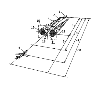
Fig. 1 ¨ a diagram illustrating relative position of the standardized
minimum separation distance , buffer zone, reference distance and
recommended maximum distance at implementation of the method according
to the invention;
Fig. 2 ¨ a diagram of the on-board system according to the invention.
However, the implementation examples are not exhaustive, do not limit
the possibilities of the invention embodiment and are not beyond the scope of
the claims.
Best embodiment of the invention
The method for ensuring minimum longitudinal separation distance
under wake turbulence conditions according to the invention can be
I
CA 02883345 2015-02-25
. '
14
implemented with the movement of at least one leading aircraft, generating
wake vortices and the second aircraft following the first one during takeoff
or
landing on the same runway or on two parallel runways located near each
other, or during in-trail flight at neighboring altitudes, when there is a
risk of
possible wake turbulence from the first aircraft along the course of the
second
aircraft, as illustrated in Figure 1.
When moving along the course of the leading aircraft 1, generating a
wake 2, and of the aircraft 3 following the aircraft 1 at the current actual
distance 4, for example, during in-trail flight at neighboring altitudes,
according to the invention, the compliance with the standardized minimum
separation distance 5 shall be ensured, which is determined on the basis of
the
data on wake vortex turbulence conditions provided by the traffic control unit
for longitudinal separation, taking into account the type and category of
aircraft 1 and 3. According to the method for ensuring minimum longitudinal
separation distance, the pilot of the aircraft 3 selects the value of the
buffer
zone 6, which provides the responsiveness of the pilot and the control system
of the aircraft 3 to the command for changing its flight velocity. At the same
time, the value of the buffer distance 6 can be selected based on the skills
of
the pilot and velocity control system of the aircraft 3; it may be changed
during the flight as the flight performances of the aircraft are changed; it
may
be different for different types of aircraft.
According to the invention, along the sight line 7 connecting the gravity
centers of the aircraft 1 and 3, it is possible to define the design value of
the
recommended maximum distance 8 as the sums of the value of the specified
minimum separation distance 5 and the value of the buffer zone 6.
It is known that the intensity of acceleration and deceleration of the
aircraft in nearly horizontal flight depends on the excess thrust, and
aircraft
acceleration performances depend, to a large extent, on the engine
CA 02883345 2015-02-25
acceleration capability ¨ the time interval from the beginning of throttle
advancing to the achievement of the specified increased thrust mode. It is
also
known that for the in-flight deceleration of the aircraft, the engines are
switched to the flight idling power mode, and to increase the drag, brake
flaps, gear extension, and other means may be applied. Due to the fact that
according to this method, control over the execution of the aircraft braking
and acceleration mode is granted to the pilot, he can execute the deceleration
or acceleration command and maintain the deceleration or acceleration mode
by using standard techniques of deceleration or acceleration or maintain the
current mode unchanged if the command to change the mode has not been
received.
According to the invention, the value of the reference distance 9 is
defined as the arithmetic average between the values of the specified
standardized minimum separation distance 5 and the recommended
maximum distance 8.
According to the invention, a simulation of the reference plane 10 on the
edge 11 of the buffer zone 6 with the limit of the standardized minimum
separation distance 5 is performed. The reference plane 10 is used to
determine the presence or absence of wake turbulence at the edge 11 of the
buffer zone 6 according to the airspace observation results made by the
aircraft surveillance system, and to assess their hazard level for the
aircraft 3,
for example, based on the data that characterize in the reference plane 10
wake vortex circulations 12 , distance between circulations 12, and location
of circulations 12 with respect to the intersection point 13 of the sight line
7
with the reference plane 10.
On-board system for ensuring minimum longitudinal separation
distance under wake turbulence conditions , according to the invention and in
the variant presented in Figure 2, includes the distance control device 18,
the
CA 02883345 2015-02-25
16
wake turbulence control device 19, the flight dynamics control device 20, and
the renderer 21 that are connected at least to the aircraft electronic
computing
device 14, to the aircraft surveillance system 15, to the aircraft control
system
16, and to the aircraft communication system 17.
The distance control device 18 includes the data receiving unit 22, the
data transmitting unit 23, the distance calculating unit 24, the reference
plane
simulating unit 25, and the distance comparing unit 26, and ensures:
- obtaining and storing of information and building databases;
- determining the standardized minimum separation distance 5;
- selecting the buffer zone 6 value in the dynamic mode and saving the
selected value;
- calculating the recommended maximum distance 8 value and
preserving the calculated values;
- calculating the reference distance 9 value as the average between the
values of recommended maximum distance 8 and standardized minimum
separation distance 5;
- simulating the reference plane 10 on the edge 11 of the buffer zone 6
with the standardized minimum separation distance 5 perpendicular to the
sight line 7;
- continuously calculating the current actual distance 4 and its
continuous comparison with the recommended maximum distance 8 value,
reference distance 9 value, and standardized minimum separation distance 5
value;
- generating a report on exceeding or reducing the actual distance 4 in
relation to the recommended maximum distance 8, reference distance 9 and
minimum separation distance 5, or reports on the equality of the actual
distance 4 to one of the specified values;
- transmitting the generated report to the flight dynamics control device
CA 02883345 2015-02-25
17
20 of the aircraft 3, to the aircraft electronic computing device 14 and to
the
aircraft communication system 17 for their communication to the traffic
control unit.
Furthermore, according to the invention, the distance control device 18
can be adapted to determine the standardized minimum separation distance 5
based on the standards set for wake turbulence conditions for longitudinal
separation taking into account the type and category of the aircraft 1 and 3.
Furthermore, the distance control device 18 can be adapted to calculate
the actual distance 4 based on the velocity of the aircraft 1 and 3 and their
location in space.
Furthermore, the data receiving unit 22, data transmitting unit 23,
distance calculating unit 24, reference plane simulating unit 25, and distance
comparing unit 26 can be realized by using the existing on-board aircraft
equipment and implementing various acceptable computing algorithms.
The wake turbulence control device 19 contains the data receiving unit
27, the data transmitting unit 28, the unit for determination of the wake
hazard level 29, and the unit for computing the risks of aircraft's
interaction
with wake turbulence 30, and ensures:
- obtaining and storing information and construction of databases;
- receiving from the aircraft surveillance system 15 the results of the
airspace scan obtained in the area of the specified reference plane 10 on the
edge 11 of the buffer zone 6 with the standardized minimum separation
distance 5 ;
- generating a report on an inadmissible entrance area 31 (Fig. 1) present
on the edge 11 of the buffer zone 6 at the direction of the aircraft 3
movement
if the risk value exceeds the abovementioned threshold value, or generating a
report on the absence of such an area;
- determining the hazard level of the wake vortex 2 turbulence on the
1
CA 02883345 2015-02-25
'
18
edge 11 and assessing the risk of aircraft 3 interacting with the dangerous
wake turbulence in an inadmissible area 31 by comparing the risk value to the
admissible risk threshold;
- continuously transmitting the generated report to the aircraft electronic
computing device 14, to the flight dynamics control device of the aircraft 20
and to the communication system of the aircraft 3 for their further
communication to the traffic control unit.
Furthermore, according to the invention, the wake turbulence control
device 19 can be adapted for analysis of the wake turbulence hazard level
based on its circulations 12, distance between circulations 12, and location
of
circulations 12 with respect to the point of intersection 13 of the sight line
7
with the reference plane 10.
The data receiving unit 22, data transmitting unit 23, distance
calculating unit 24, reference plane simulating unit 25, and distance
comparing unit 26 can be realized by using the existing on-board equipment
and implementing different methods of analyzing wake turbulence hazard
level.
The flight dynamics control device 20 includes the data receiving unit
32, the data transmitting unit 33, the data complexification unit 34, and the
unit 35 for generating commands to the aircraft control system, and ensures:
- obtaining reports from the distance control device 18 concerning the
following events: the value of the actual distance 4 exceeds the value of the
recommended maximum distance 8; the value of the actual distance 4 equals
the recommended maximum distance 8; the actual distance 4 value equals or
exceeds the maximum reference distance 9; the value of the actual distance 4
is less than the value of the reference distance 9; the value of the actual
distance 4 equals the standardized minimum separation distance 5;
- obtaining reports from the turbulence control device 19 on the absence
'
CA 02883345 2015-02-25
. ,
19
or presence of the inadmissible area 31 on the edge 11 of the buffer zone 6;
- generating a deceleration command if the inadmissible area 31 is
present on the edge 11 of the buffer zone 6, and if the actual distance 4 is
less
than the reference distance 9 value;
- generating a deceleration command if the inadmissible area 31 is
absent on the edge 11 of the buffer zone 6, and if the actual distance 4 is
less
than the value of the reference distance 9;
- generating a deceleration command if the inadmissible area 31 is
absent on the edge 11 of the buffer zone 6, and if the actual distance 4 is
equal
to the standardized minimum separation distance 5;
- generating an acceleration command if an inadmissible area 31 is
absent on the edge 11 of the buffer zone 6, and if the actual distance is
larger
than the maximum reference distance 9;
- generating an acceleration command if an inadmissible area 31 is
absent on the edge 11 of the buffer zone 6, and if the actual distance 4 is
larger
than the recommended maximum distance 8;
- transmitting the acceleration or deceleration command to the aircraft 3
control system 16.
The visualization device 21 ensures dynamically generating and
displaying on the screen of the aircraft 3 information at least on the value
of
the actual distance 4, on the necessary transition into the braking mode, on
receiving the braking command by the control system 16 of the aircraft 3, on
the movement of the aircraft 3 in the deceleration mode, on the termination of
the deceleration mode; on the necessity of transition to the acceleration
mode,
on receiving the acceleration command by the aircraft 3 control system 16, on
the movement of the aircraft 3 in the acceleration mode, on the termination of
the acceleration mode; on the constant velocity flight mode.
The visualization device 21, according to the invention, can be adapted
,
CA 02883345 2015-02-25
=
to perform light indication of deceleration, acceleration, and constant
velocity
modes, with activation of indicators of different colors and configurations,
for example, according to the traffic light type: red light ¨ deceleration,
green
light ¨ constant velocity mode, blue light ¨ acceleration mode. This
indication
can be performed in different modes of interruption while indicating the
necessity to transit to another flight mode and indicating deceleration or
acceleration command receipt by the control system 16 of the aircraft 3 and in
continuous mode, during the aircraft's movement in the deceleration or
acceleration mode , respectively.
These specified distance control device 18, wake turbulence control
device 19, flight dynamics control device 20, visualization device 21, and
their integrated units can be realized with adaptation of the existing on-
board
aircraft equipment to the fulfilment of new tasks using appropriate
computational algorithms and software.
The method for ensuring minimum longitudinal separation distance
under wake turbulence conditions ,according to the invention, is implemented
by using the selected standardized minimum separation distances , the
calculated values of the recommended maximum distance 8, reference
distance 9, and buffer zone 6, and database information generated by the
distance control device 18 and containing, data at least on: the current
movement parameters of the aircraft, in respect of which the provision of the
minimum separation distance is assumed; the standardized minimum
separation distance for the interaction of the aircraft in wake turbulence;
the
capacities of the aircraft to change the velocity modes; as well as database
information generated by the wake turbulence control device 19 and
containing, data at least on: the characteristic values of the wake2
circulations
12 of the aircraft 1, on the distance between the circulations 12 in the
vicinity
of the aircraft 1, and on the change of this distance as the wake 2
r
CA 02883345 2015-02-25
'
21
progressively moves away from the aircraft 1; data on the acceptable risk
thresholds of the interaction of the aircraft 3 with the dangerous wake
turbulence.
To implement the method in accordance with the invention, it is required
to carry out, with the help of the distance control device 18, a continuous
calculation of the current actual distance 4 between the aircraft 1 and, to
perform its continuous comparison with the recommended maximum
distance 8 value, the reference distance 9 value, and the standardized
minimum separation distance 5 value, stored in the database of the distance
control device 18. Using the distance control device 18, it is possible to
generate a report on exceedance, equality or reduction of the actual distance
4
in relation to the recommended maximum distance 9 and to the minimum
separation distance 5; or a report on the equality of the actual distance 4 to
one of these values. The generated reports are transmitted to the flight
dynamics control device 20 and to the aircraft communication system 17 for
their further communication to the traffic control unit. The calculations,
specified in this method, can be performed using electronic means and known
calculation algorithms.
The wake turbulence control device 19 communicates directly with the
aircraft 3 surveillance system 15 and receives the results of the airspace
scan,
obtained in the area of the specified reference plane 10 at the edge 11 of the
buffer zone 6 with the standardized minimum separation distance 5, that
contain information on the parameters of the detected wake turbulence;
determines the wake hazard level on the edge 11; assesses the risk of the
interaction of plane 3 with the dangerous turbulence from the wake 2 by
comparing the risk assessment to the acceptable risk threshold . In case the
risk value exceeds the abovementioned threshold value, the wake turbulence
control device 19 generates a report on the presence of an inadmissible
CA 02883345 2015-02-25
=
22
entrance area 31 on the edge 11 of the buffer zone 6 on the course of the
aircraft 3 and, if the risk value is less than the threshold value, a report
on the
absence of the inadmissible area is generated. The wake turbulence control
device 19 continuously transmits the generated reports to the flight dynamics
control device 20 and to the aircraft 3 communication system 17 for their
further communication to the traffic control unit.
The flight dynamics control device 20, based on the report from the
distance control device 18 on the exceedance, equality or reduction of the
actual distance 4 in relation to the recommended maximum distance 8 value,
the reference distance 9 value, and the standardized minimum separation
distance 5 value, as well as based on the reports received from wake
turbulence control device 19 on the presence or absence on the edge 11 of the
buffer zone 6 of an area 31, inadmissible for the entrance of aircraft 3,
generates a deceleration or acceleration command or generates a report on the
absence of such a necessity.
If the report on the presence of an inadmissible area 31 on the edge 11 of
the buffer zone 6 is urgent, and if the value of the actual distance 4 is less
than
the value of the reference distance 9, a deceleration command is generated,
which increases the actual distance 4 up to the value of reference distance 9
and, therefore, increases the distance between the aircraft 3 and the edge 11
of
the standardized minimum separation distance 5.
If both reports on the presence of an inadmissible area 31 on the edge 11
of the buffer zone 6 and on the value of the actual distance 4 being less than
the value of the reference distance 9 turn out to be simultaneously urgent, a
deceleration command is generated, which increases the actual distance 4, for
example, up to the value of the reference distance 9.
If both reports on the presence of an inadmissible area 31 on the edge 11
of the buffer zone 6 and on the value of the actual distance 4 being equal to
CA 02883345 2015-02-25
23
the standardized minimum separation distance 5 turn out to be
simultaneously urgent, a deceleration command is generated, which ensures
an increase of the actual distance 4, for example, up to the value of the
reference distance 9.
If both reports on the absence of an inadmissible area 31 and on the
value of the actual distance 4 being larger than the value of the maximum
reference distance 9, but less than the recommended maximum distance 8,
turn out to be simultaneously urgent, an accelerating command is generated,
which reduces the actual distance 4 down to the value of the reference
distance 9.
If both reports on the absence of an inadmissible area 31 and on the
value of the actual distance 4 being larger than the value of the recommended
maximum distance 8 turn out to be simultaneously urgent, an accelerating
command is generated, which reduces the actual distance 4 down to the value
of reference distance 9.
During the deceleration or acceleration mode of the aircraft 3, the real
situation will be altered, and, at receiving of other reports, the flight
dynamics
control device 20 will generate another command or stay in the previous
mode depending on whether the change of the aircraft velocity takes place to
change the actual distance 4 between the aircraft.
It should be clear to the air traffic specialists that, according to the
invention, the present method not only ensures the protection of the following
aircraft 3 from the hazard of the wake 2 behind the leading aircraft 1 and the
maintenance of the standardized minimum separation distance 5 , but also
compensates the non-observance of the distances between the aircraft caused
by deceleration or acceleration of the leading aircraft 1.
Information on the actual flight situation and its changes, which led to
the need for a prompt response, is displayed by the renderer 21 on the screen
CA 02883345 2015-02-25
24
of the aircraft 3 and may contain information on the actual distance value; on
velocity changes; on the receipt of a deceleration command by the control
system 16 of the aircraft 3; on movement of the aircraft 3 in the deceleration
mode, ; on the termination of the deceleration mode; on the receipt of an
acceleration command by the control system 16 of the aircraft 3; on the
movement of the aircraft 3 in the acceleration mode; on the termination of the
acceleration mode; on the constant velocity flight mode.
The visualization device 21 can provide a symbolic and/or light
indication, for example, with activation of indicators of different colors and
configurations according to the traffic light type: red light ¨ deceleration,
green light ¨ constant velocity mode, blue light ¨ acceleration mode. This
indication can be, for example, intermittent, with different intervals of
signal
interruption, when informing about the necessity to change the velocity and
receiving a command by the aircraft control system 16; and continuous, when
the aircraft moves in the deceleration or acceleration mode, respectively.
It should be clear to the air traffic specialists that the information coming
from the on-board system may be used to generate the black box reference
data that, in the event of dangerous collision, will allow to analyze the
compliance with the longitudinal separation and pilot's behavior regardless
of the actions of the ATC officer.
The method and on-board system for ensuring minimum longitudinal
separation distance under wake turbulence conditions according to the
invention have obvious advantages in comparison with the known proposed
and currently implemented technical solutions, as they both ensure
compliance with the standardized minimum separation distance and offer the
means of its maintenance within the set limits without compromising wake
vortex safety, which allows to improve the flight dispatching process and
increase the airport capacity, as well as to avoid the impact of the "human
CA 02883345 2015-02-25
=
factor" conditioned by the experience of the pilot and flying control officer
and by their ability to make quick decisions on the flight operation process
in
dangerous situations.
Industrial applicability
Method and on-board system for ensuring minimum longitudinal
separation distance under wake turbulence conditions according to the
invention can be implemented using the known technologies and equipment
and can find their application for aircraft of any category and destination,
which will help to increase the airport capacity and reduce the probability of
flight accidents.