Note: Descriptions are shown in the official language in which they were submitted.
CA 02883668 2015-03-02
=
SYSTEM AND METHOD FOR ANALYSIS OF DESIGNS OF A SEISMIC SURVEY
TECHNICAL FIELD
[0001] The present invention relates to seismic imaging of subsurface
features.
BACKGROUND
100021 In hydrocarbon exploration, seismic imaging may be used to determine
likely
locations for exploitable resources. Planning for a seismic imaging project
requires modeling
the expected velocity and reflection response in the subsurface region under
study. Modeled
predictions may be used to generate the illumination pattern for the imaging
operation.
Methods of modeling illumination may suffer from various drawbacks relating to
accuracy
and/or computational burden. Thus, the inventors have determined that an
improved
approach to illumination modeling would be useful.
BRIEF DESCRIPTION OF DRAWINGS
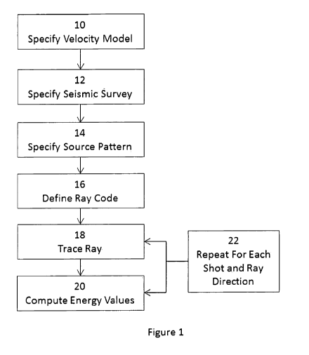
100031 Figure 1 is a flow chart illustrating a workflow in accordance with an
embodiment of
the invention; and
[00041 Figure 2 is a map of illumination energy over a selected horizon
produced using a
method in accordance with an embodiment of the invention.
DETAILED DESCRIPTION
[00051 In a seismic survey, illumination may be considered to be the seismic
energy from a
source or sources that reflects off of a given region of a target horizon and
is returned to
receivers. As will be appreciated, this means that seismic energy that is
attenuated or scattered
prior to reaching the reflector, energy that reflects but is not recorded, or
energy that is not
reflected (e.g., energy that is absorbed or transmitted) is not considered to
be "illumination."
[00061 Understanding how a selected seismic survey geometry (location of
sources and
receivers) acts to illuminate the subsurface allows for changes in survey
design to improve the
1
CA 02883668 2015-03-02
WO 2014/074173 PCT/US2013/046387
likelihood of capturing a clear image of the region under study. For example,
if there is an
elongated trench in the zone, it may be useful to ensure good illumination
along the axis of the
trench. If there are shallow reflectors that may tend to shadow deeper
features of interest, it may
be useful to design the survey so as to undershoot the obstacles.
[0007] In an embodiment, a ray tracing technique is used to simulate an
illumination response of
a reflecting surface to a specified acquisition geometry. In the simulation,
an energy source has a
substantially uniform distribution of emerging rays over all solid angles, so
that each ray models
an equal contribution of source energy. This may allow for a simplification by
avoiding the
requirement of explicit computation of spreading factors. At the receiving
surface, a Fresnel zone
is applied at the dominant frequency around the point of the arriving ray. In
embodiments, the
method employs the first Fresnel zone, though in principle higher order zones
could be used.
Receivers, each weighted by position within the Fresnel zone on the receiving
surface, contribute
to the energy of the ray. Receivers outside the Fresnel zone contribute zero
energy for the ray
and can be ignored, generally reducing the computational burden. The energy is
summed to
predict the illumination energy at the reflecting point of the ray.
[0008] Because Fresnel zones are used, the wave-equation response is
approximated, and
illumination over a reflecting horizon for a given acquisition geometry and
reflecting horizon
shape is predicted with good accuracy. Because the Fresnel zone calculation is
performed for the
receiving surface, a useful degree of accuracy is achieved without requiring
excessive
computational burden, which may allow for generating larger numbers of test
geometries for a
given project.
[0009] In an embodiment, the product of the method is a triangulated surface
with computed
energy value as a property of that surface. That is, each vertex of the
surface may have an
illumination energy value associated with it. Once this product is generated,
it may be used
as the basis for a survey design. More typically, a number of such surfaces,
each generated
for a respective set of assumptions (e.g., different realizations of the
velocity model, different
geometries for the design) are generated to allow design choices to be
evaluated. Given the
illumination product, a decision may be made regarding redesign of the seismic
survey.
Alternately, the illumination surface may allow a decision maker to make an
informed
decision regarding the sufficiency of a particular design. That is, while a
different design
might provide superior illumination at a greater cost, the improvement in
illumination may be
small compared to the increased cost.
2
CA 02883668 2015-03-02
WO 2014/074173 PCT/US2013/046387
[0010] In an embodiment illustrated in Figure 1, a workflow begins with
specification of a
velocity model for the subsurface region under study 10. The velocity model
may include
structural horizons in the form of triangulated surfaces, and velocities
representing the
modeled speed of seismic waves in the material present in the subsurface. For
velocity
models having high degrees of non-homogeneity, and in particular, where there
is a high
spatial frequency variation (e.g., structures having steep dip, rapidly
varying geology, or
other complex structures), calculated illumination may tend to be poor and
many regions
may be shadowed, blurred or otherwise poorly imaged.
[0011] A corresponding seismic survey is specified 12. The specification may
include
structural surfaces where the sources (shots) and receivers are positioned as
well as X-Y
coordinates for the sources and receivers. The X-Y coordinates along with the
structural
surfaces together define X-Y-Z locations for each source and each receiver.
[0012] A set of starting ray directions at the source (i.e., a source
radiation pattern) is
specified 14. The specification may include minimum and maximum inclination
angles,
which may be measured from the downward vertical) and a delta angle. A set of
starting
directions is derived so that the solid angle separating adjacent directions
is uniform.
[0013] A sequence of structural boundaries with which each ray will interact
is defined,
along with the type of interaction 16. This sequence may be referred to as a
ray code.
Relevant types of interaction may include reflection, transmission, and/or
mode conversion.
A primary reflector corresponding to the horizon for which the illumination
map is to be
generated is selected.
[0014] For each shot and each ray starting direction, a ray is traced in
accordance with the
ray code 18, using any appropriate ray tracing approach.
[0015] For each ray that satisfies the ray code, an energy value is computed
20. Energy is
determined by determining a velocity (for example, a root mean squared
velocity may be
used), computing a Fresnel zone radius and producing a weighted sum over all
receivers
within the Fresnel zone. That energy is then added to the energy totals of all
vertices of the
primary reflector within the capture radius of the ray's reflection point. The
ray trace and
energy value computation is repeated for every shot and ray takeoff direction
22. As will be
appreciated, the method may provide an illumination map that approximates the
actual
3
CA 02883668 2015-03-02
WO 2014/074173 PCT/US2013/046387
illumination without requiring any wave equation computation, thereby greatly
reducing the
computational burden. An example of an implementation of the foregoing steps
are
described in greater detail below.
[0016] An example of such an illumination map is illustrated in Figure 2 for a
mirror
wavefield. In the illustrated example, the inner rectangle is the area of
interest. That is, if
that portion of the horizon is sufficiently illuminated for the proposed
acquisition survey
geometry, that geometry is acceptable.
[0017] A root mean squared velocity is computed for a in accordance with
Equation 1:
IP"' *-1-*
Ennz
I ak.
(Eqn. 1)
where V is the interval velocity and t is time.
[0018] A Fresnel zone radius is computed for a selected dominant frequency fin
accordance
with Equation 2:
(Eqn. 2)
The dominant frequency will generally be in the range of 8Hz-60Hz, and a
frequency of
about 25Hz may be of particular use in typical seismic imaging applications.
[0019] The central frequency of the wavelet may be selected for convenience,
and may be
determined based on the spectrum of the energy source and on any attenuation
and/or
frequency dispersion along the travel path. As will be appreciated, other
frequencies may be
selected as best representing the energy of the ray. For example, where the
ray's spectrum is
not particularly Gaussian, a non-central frequency may better represent the
energy of the ray.
Likewise, because attenuation is frequency dependent and the wave will tend to
lose high
frequency as it penetrates deeper, for deeper horizons, a lower frequency will
generally be
used, while for shallower horizons higher frequencies are applicable.
4
CA 02883668 2015-03-02
WO 2014/074173 PCT/US2013/046387
[0020] The weighted sum of the receivers is calculated:
I * IP PCI1
cos
*
E¨
(Eqn. 3)
where P is the two dimensional location of a receiver and Po is the two
dimensional location
of the receiver end of the ray. As will be appreciated, a different weighting
function could be
used, but the above is generally a useful approach.
[0021] Finally, for each surface vertex of the reflector that lie within a
capture radius, Q, E is
added to its total energy using a cosine taper as a weighting function:
_
,
'3 =cos _____
1*,
26'r - (Eqn. 4)
where qo is the location of the primary reflection point of the ray and q is
the location of a
vertex.
[0022] In an embodiment, the illumination surface may be used as the basis for
image
compensation algorithms (e.g., adjusting amplitudes in view of predicted
illumination
values).
[0023] While the disclosure relates primarily to seismic acquisition
techniques where the
receivers are at the surface, it may find applicability to other techniques.
For example, in a
vertical seismic profile in which sensors are in a borehole, the same approach
may be used.
[0024] The above described methods can be implemented in the general context
of
instructions executed by a computer. Such computer-executable instructions may
include
programs, routines, objects, components, data structures, and computer
software technologies
that can be used to perform particular tasks and process abstract data types.
Software
implementations of the above described methods may be coded in different
languages for
application in a variety of computing platforms and environments. It will be
appreciated that
the scope and underlying principles of the above described methods are not
limited to any
particular computer software technology.
CA 02883668 2015-03-02
WO 2014/074173 PCT/US2013/046387
[0025] Moreover, those skilled in the art will appreciate that the above
described methods
may be practiced using any one or a combination of computer processing system
configurations, including, but not limited to, single and multi-processer
systems, hand-held
devices, programmable consumer electronics, mini-computers, or mainframe
computers. The
above described methods may also be practiced in distributed computing
environments where
tasks are performed by servers or other processing devices that are linked
through a one or
more data communications networks. In a distributed computing environment,
program
modules may be located in both local and remote computer storage media
including memory
storage devices.
[0026] Also, a tangible article of manufacture for use with a computer
processor, such as a
CD, pre-recorded disk or other storage devices, could include a computer
program storage
medium and machine executable instructions recorded thereon for directing the
computer
processor to facilitate the implementation and practice of the above described
methods. Such
devices and articles of manufacture also fall within the spirit and scope of
the present
invention.
[0027] As used in this specification and the following claims, the terms
"comprise" (as well
as forms, derivatives, or variations thereof, such as "comprising" and
"comprises") and
"include" (as well as forms, derivatives, or variations thereof, such as
"including" and
"includes") are inclusive (i.e., open-ended) and do not exclude additional
elements or steps.
Accordingly, these terms are intended to not only cover the recited element(s)
or step(s), but
may also include other elements or steps not expressly recited. Furthermore,
as used herein,
the use of the terms "a" or "an" when used in conjunction with an element may
mean "one,"
but it is also consistent with the meaning of "one or more," "at least one,"
and "one or more
than one." Therefore, an element preceded by "a" or "an" does not, without
more constraints,
preclude the existence of additional identical elements. The use of the term
"about" with
respect to numerical values generally indicates a range of plus or minus 10%,
absent any
different common understanding among those of ordinary skill in the art or any
more specific
definition provided herein.
[0028] While in the foregoing specification this invention has been described
in relation to
certain preferred embodiments thereof, and many details have been set forth
for the purpose
of illustration, it will be apparent to those skilled in the art that the
invention is susceptible to
6
CA 02883668 2015-03-02
WO 2014/074173 PCT/US2013/046387
alteration and that certain other details described herein can vary
considerably without
departing from the basic principles of the invention. For example, the
invention can be
implemented in numerous ways, including for example as a method (including a
computer-
implemented method), a system (including a computer processing system), an
apparatus, a
computer readable medium, a computer program product, a graphical user
interface, a web
portal, or a data structure tangibly fixed in a computer readable memory.
7