Note: Descriptions are shown in the official language in which they were submitted.
CA 02890150 2016-10-05
PASSIVE MAGNETIC RANGING FOR SAGD AND RELIEF WELLS VIA A
LINEARIZED TRAILING WINDOW KALMAN FILTER
BACKGROUND OF THE DISCLOSURE
1. Field of the Disclosure
[0001] The present disclosure relates to directional drilling and, in
particular, to a
method of determining a location of a well drilled with respect to a pre-
existing reference
well.
2. Description of the Related Art
[0002] Passive magnetic ranging arises out of the need to accurately determine
the
location of an existing well relative to a well being drilled. Relative
position accuracy from
survey-derived estimates is often insufficient due to the accumulation of
measurement errors
as the depth of the well increases. Passive magnetic ranging is a process for
determining a
relative position of a magnetic source in a reference well with respect to a
magnetometer in a
new well. A number of measurements and variables are used to determine the
relative
position. Exemplary measurements include, but are not limited to, measurement
of the earth's
magnetic field, orientation of the sensor, the strength and distribution of
the source field (i.e.,
the residual magnetic fields in the reference well), sensor biases, scale
factors, etc. These
variables and measurements have uncertainties associated with them that make
it difficult to
determine relative position from a single magnetometer vector measurement.
Thus, there is a
need for improved methods for directional drilling of a well next to a
reference well that
account for all such error sources.
SUMMARY OF THE DISCLOSURE
[0003] In one aspect, the present disclosure provides a method of drilling a
well,
including: obtaining a first estimate of a location of the well with respect
to a reference well
at a selected depth; obtaining a magnetic measurement at the selected depth
using a sensor,
wherein the obtained magnetic measurement is related to a residual magnetic
charge
distribution in the reference well; determining an expected value of the
magnetic
measurement at the selected depth from the residual magnetic charge
distribution; obtaining a
1
CA 02890150 2015-04-30
WO 2014/070536 PCT/US2013/066278
second estimate of the location of the well using the first estimate of the
location, the
obtained magnetic measurement and the expected value of the magnetic
measurement; and
altering a drilling parameter of the well using the second estimate of the
location.
[0004] In another aspect, the present disclosure provides a system for
drilling a well
proximate a reference well, the system includes a drill string configured to
drill the well; a
sensor disposed on the drill string configured to measure a downhole magnetic
field; and a
processor configured to: obtain a first estimate of a location of the well
with respect to a
reference well at a selected depth of the sensor, obtain from the sensor a
magnetic
measurement at the selected depth related to a residual magnetic charge
distribution in the
reference well, determine an expected value of the magnetic measurement at the
selected
depth from the residual magnetic charge distribution, obtain a second estimate
of the location
of the well using the first estimate of the location, the obtained magnetic
measurement and
the expected value of the magnetic measurement, and alter a drilling parameter
of the well
using the second estimate of the location.
[0005] In yet another aspect, the present disclosure provides a computer
readable
medium having stored thereon instructions that when read by at least one
processor enable
the at least one processor to perform a method of drilling a well, the method
including:
obtaining a magnetic measurement from a sensor at a selected depth, wherein
the obtained
magnetic measurement is related to a residual magnetic charge distribution in
the reference
well, determining an expected value of the magnetic measurement at the
selected depth from
the residual magnetic charge distribution, obtaining a second estimate of the
location of the
well using the first estimate of the location, the obtained magnetic
measurement and the
expected value of the magnetic measurement, and altering a drilling parameter
of the well
using the second estimate of the location.
[0006] Examples of certain features of the apparatus and method disclosed
herein are
summarized rather broadly in order that the detailed description thereof that
follows may be
better understood. There are, of course, additional features of the apparatus
and method
disclosed hereinafter that will form the subject of the claims.
BRIEF DESCRIPTION OF THE DRAWINGS
[0007] For detailed understanding of the present disclosure, references should
be
made to the following detailed description of the exemplary embodiment, taken
in
conjunction with the accompanying drawings, in which like elements have been
given like
numerals and wherein:
2
CA 02890150 2015-04-30
WO 2014/070536 PCT/US2013/066278
FIG. 1 is a schematic diagram of an exemplary drilling system that includes a
drill
string having a drilling assembly attached to its bottom end that includes a
steering unit
according to one embodiment of the disclosure;
FIG. 2 shows a reference wellbore and a new wellbore being drilled alongside
the
reference wellbore at a location laterally displaced from the reference
wellbore;
FIG. 3 shows an exemplary array suitable for use in determining a wellbore
location
using the methods disclosed herein; and
FIG. 4 shows a flowchart of an exemplary method of drilling a well with
respect to a
reference well.
DETAILED DESCRIPTION OF THE DISCLOSURE
[0008] FIG. 1 is a schematic diagram of an exemplary drilling system 100 that
includes a drill string having a drilling assembly attached to its bottom end
that includes a
steering unit according to one embodiment of the disclosure. FIG. 1 shows a
drill string 120
that includes a drilling assembly or bottomhole assembly ("BHA") 190 conveyed
in a
borehole 126, also referred to herein as a well or wellbore. The drilling
system 100 includes
a conventional derrick 111 erected on a platform or floor 112 which supports a
rotary table
114 that is rotated by a prime mover, such as an electric motor (not shown),
at a desired
rotational speed. A tubing (such as jointed drill pipe) 122, having the
drilling assembly 190
attached at its bottom end extends from the surface to the bottom 151 of the
borehole 126. A
drill bit 150, attached to drilling assembly 190, disintegrates the geological
formations when
it is rotated to drill the borehole 126. The drill string 120 is coupled to a
draw-works 130 via
a Kelly joint 121, swivel 128 and line 129 through a pulley. Draw-works 130 is
operated to
control the weight on bit ("WOB"). The drill string 120 may be rotated by a
top drive (not
shown) instead of by the prime mover and the rotary table 114. The operation
of the draw-
works 130 is known in the art and is thus not described in detail herein.
[0009] In one aspect, a suitable drilling fluid 131 (also referred to as
"mud") from a
source 132 thereof, such as a mud pit, is circulated under pressure through
the drill string 120
by a mud pump 134. The drilling fluid 131 passes from the mud pump 134 into
the drill
string 120 via a desurger 136 and the fluid line 138. The drilling fluid 131a
from the drilling
tubular discharges at the borehole bottom 151 through openings in the drill
bit 150. The
returning drilling fluid 131b circulates uphole through the annular space 127
between the drill
string 120 and the borehole 126 and returns to the mud pit 132 via a return
line 135 and drill
cutting screen 185 that removes the drill cuttings 186 from the returning
drilling fluid 13 lb.
3
CA 02890150 2015-04-30
WO 2014/070536 PCT/US2013/066278
A sensor S1 in line 138 provides information about the fluid flow rate. A
surface torque
sensor S2 and a sensor S3 associated with the drill string 120 provide
information about the
torque and the rotational speed of the drill string 120. Rate of penetration
of the drill string
120 may be determined from the sensor S5, while the sensor S6 may provide the
hook load of
the drill string 120.
[0010] In some applications, the drill bit 150 is rotated by rotating the
drill pipe 122.
However, in other applications, a downhole motor 155 (mud motor) disposed in
the drilling
assembly 190 also rotates the drill bit 150. The rate of penetration ("ROP")
for a given drill
bit and BHA largely depends on the WOB or the thrust force on the drill bit
150 and its
rotational speed.
[0011] A surface control unit or controller 140 receives signals from the
downhole
sensors and devices via a sensor 143 placed in the fluid line 138 and signals
from sensors Si-
S6 and other sensors used in the system 100 and processes such signals
according to
programmed instructions provided from a program to the surface control unit
140. The
surface control unit 140 displays desired drilling parameters and other
information on a
display/monitor 141 that is utilized by an operator to control the drilling
operations. The
surface control unit 140 may be a computer-based unit that may include a
processor 142
(such as a microprocessor), a storage device 144, such as a solid-state
memory, tape or hard
disc, and one or more computer programs 146 in the storage device 144 that are
accessible to
the processor 142 for executing instructions contained in such programs. The
surface control
unit 140 may further communicate with a remote control unit 148. The surface
control unit
140 may process data relating to the drilling operations, data from the
sensors and devices on
the surface, data received from downhole and may control one or more
operations of the
downhole and surface devices.
[0012] The drilling assembly 190 also contain formation evaluation sensors or
devices (also referred to as measurement-while-drilling, "MWD," or logging-
while-drilling,
"LWD," sensors) determining resistivity, density, porosity, permeability,
acoustic properties,
nuclear-magnetic resonance properties, corrosive properties of the fluids or
formation
downhole, salt or saline content, and other selected properties of the
formation 195
surrounding the drilling assembly 190. Such sensors are generally known in the
art and for
convenience are generally denoted herein by numeral 165. The drilling assembly
190 may
further include a variety of other sensors and communication devices 159 for
controlling
and/or determining one or more functions and properties of the drilling
assembly (such as
velocity, vibration, bending moment, acceleration, oscillations, whirl, stick-
slip, etc.) and
4
CA 02890150 2015-04-30
WO 2014/070536 PCT/US2013/066278
drilling operating parameters, such as weight-on-bit, fluid flow rate,
pressure, temperature,
rate of penetration, azimuth, tool face, drill bit rotation, etc.
[0013] The drilling assembly may further include a magnetometer 192 for
determining a local magnetic field. The magnetometer 192 may be a three-axis
magnetometer for obtaining magnetometer measurements along three orthogonal
directions.
In an exemplary embodiment, one of the orthogonal directions (i.e., the z-
direction) is
directed along a longitudinal axis of the drill string and the other
orthogonal directions (i.e.,
the x-direction and y-direction) are in a transverse plane of the drill string
and extending
radially outward from the drill string. The magnetometer 192 may measure the
local
magnetic field to obtain a measurement affected by the presence of the
residual magnetic
charge on a casing in a nearby reference well. These measurements may be sent
to a
processor that uses the measurements to determine a relative distance to the
reference well.
The drilling assembly may further include survey instruments for obtaining
survey
parameters, such as borehole inclination and azimuth. In one embodiment, the
magnetometer
192 is located proximate a drill bit 215, thereby improving the relevancy of
obtained
measurements to the drill bit location and therefore the accuracy of the drill
bit location. The
estimated relative distance may be related to a sensor, a BHA, a drill bit or
other suitable
location of the drill string.
[0014] Still referring to FIG. 1, the drill string 120 further includes energy
conversion
devices 160 and 178. In an aspect, the energy conversion device 160 is located
in the BHA
190 to provide an electrical power or energy, such as current, to sensors 165
and/or
communication devices 159. Energy conversion device 178 is located in the
drill string 120
tubular, wherein the device provides current to distributed sensors located on
the tubular. As
depicted, the energy conversion devices 160 and 178 convert or harvest energy
from pressure
waves of drilling mud which are received by and flow through the drill string
120 and BHA
190. Thus, the energy conversion devices 160 and 178 utilize an active
material to directly
convert the received pressure waves into electrical energy. As depicted, the
pressure pulses
are generated at the surface by a modulator, such as a telemetry communication
modulator,
and/or as a result of drilling activity and maintenance. Accordingly, the
energy conversion
devices 160 and 178 provide a direct and continuous source of electrical
energy to a plurality
of locations downhole without power storage (battery) or an electrical
connection to the
surface.
[0015] FIG. 2 shows a target borehole 200 (also referred to herein as a
"reference
borehole") and a new borehole 202 being drilled alongside the reference
borehole 200 at a
CA 02890150 2015-04-30
WO 2014/070536 PCT/US2013/066278
location laterally displaced from the reference borehole 200. In FIG. 2, the
two boreholes
200 and 202 are shown as being drilled from two separate rigs 220 and 222,
respectively, but
they may also be drilled using the same rig. The reference borehole 200
includes a casing
205 therein that may include one or more casing tubulars 205a, ..., 205n
coupled end-to-end
to each other. In various embodiments, the casing tubulars 205a, ..., 205n
have a residual
magnetic charge on their surface. Typically, the residual magnetic charge
results from an
integrity check of the tubular casings 205a, ..., 205n performed uphole prior
to inserting the
casing tubulars in the reference borehole 200. The magnetic inspection process
generally
involves imparting a strong magnetic charge to the casing and using the
resulting magnetic
field to observe imperfections. Once the tubular has been inspected, the
tubular is
demagnetized. Due to imperfections in the demagnetization process, a residual
magnetic
charge remains on the tubular. In various embodiments, the residual charge is
measured at
the uphole location and the measurements are stored in a memory location such
as storage
device 144. Once the tubular casing is installed in the reference borehole
200, the order of
the tubular casings 205a, ..., 205n and their locations in the reference
borehole 200 is also
stored in the memory location. Thus, a magnetic profile of the casing 205 may
be obtained.
The magnetic profile may be stored at a memory location and then used to
perform the
exemplary methods of the present disclosure to determine a relative location
and/or
orientation between new borehole 202 and reference borehole 200. The magnetic
charge
concentrations along the cased reference borehole 200 distort the Earth field
in the proximity
of the casing, usually by a few hundred nanoTesla (nT) at 5 meters distance.
In comparison,
the Earth's magnetic field is approximately 50,000nT.
[0016] Exemplary new borehole 202 contains a drill string 214 having one or
more
sensors, such as a magnetometer 212 and survey instruments. The magnetometer
212 may
include various single axis magnetometers 212x, 212y and 212z aligned along
orthogonal
directions of a coordination system of the drill string 214. An exemplary
coordinate system
includes axes X, Y and Z, wherein the Z direction is along the longitudinal
axis of the drill
string 214 and X and Y directions are in a plane transverse to the
longitudinal axis of the drill
string 214. The axial locations of transmitter and receiver coils in the
magnetic induction tool
202 are not limited to a particular configuration. The magnetometers 212x,
212y and 212z
detect the distortion in the earth's magnetic field due to the presence of the
residual magnetic
charge of the casing 205 in the reference borehole 200. A processor may be
coupled to the
magnetometer 212 to determine relative location and/or orientation or the
magnetometer 212
with respect to the reference borehole 200 using the measured magnetic fields.
In various
6
CA 02890150 2015-04-30
WO 2014/070536 PCT/US2013/066278
aspects, the determined location and/or orientation may then be used to drill
the well 202 at a
selected relation to the reference borehole 200 such as parallel to the
reference borehole 200.
[0017] In another embodiment, the residual magnetic charge distribution from
the
plurality of casings may be measured prior to insertion into the target well,
and an average
charge distribution determined. Based on an arc of downhole measurements of
the magnetic
field performed by the magnetometer 212 in the new borehole 202, a processor
may calculate
an estimated charge distribution at the casing 205 that produces the downhole
measurements.
Parameters calculated from this estimated charge distribution may then be
compared to
corresponding parameters calculated from the average charge distribution to
determine the
measured depth offset and forward/backward orientation of the pieces of casing
205 in the
target well 200 that are in the vicinity of the magnetometer 212. This casing
identification
result may be used in conjunction with the average charge distribution to aid
in determining a
location and orientation of the new borehole 202.
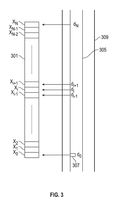
[0018] FIG. 3 shows an exemplary array 301 suitable for use in determining a
wellbore location using the methods disclosed herein. The array 301 includes a
number of
array locations X0-XN that store data obtained at given depths, wherein the
stored data is
related to determining a relative position of the well with respect to the
reference well at the
given depths. In an exemplary embodiment, the data array may hold enough
measurements
to cover a span of 60 meters of depth, with measurements being obtained every
0.5 meters.
However, the array may be selected to span any selected depth intervals and
the interval
between adjacent depths may be any selected distance or variable. The array
301 is shown in
relation to exemplary drill string 305 having a sensor 307 thereon. In an
exemplary
embodiment, as the drill string 305 moves downward into the borehole 309, the
sensor
obtains measurement at selected locations. The obtained measurements are
stored at the first
array location (X0) of the array. Any data that has been previously stored in
the first array
location X0 is moved to the second array location (Xi) and data that has been
previously
stored in the second array location (Xi) is moved to the third array location
(X2), and so on.
Data stored in the last array location (XN) is removed from the array, but not
before updating
location information for array location XN_i using methods disclosed herein.
Thus, in the
exemplary configuration of FIG .3, array location X0 corresponds to data
obtained at depth
d0, array location Xi corresponds to data obtained at depth di, etc.
[0019] In one embodiment, the data stored in the array is used to determine a
location
and/or orientation of the sensor 307 with respect to the reference well. Data
stored at array
location XN includes an estimate of the sensor location and/or orientation
relative to the
7
CA 02890150 2015-04-30
WO 2014/070536 PCT/US2013/066278
reference well when it was at depth dN. This estimate of relative location
and/or orientation is
used along with other data stored an array location XN to determine a relative
location and/or
orientation corresponding to depth dN_,. This estimated relative location
and/or orientation
corresponding to dN_, is used along with data stored at array location XN_1 to
determine an
estimated relative location and/or orientation corresponding to depth dN_2,
and so on until a
relative location and/or orientation is estimated for the sensor at depth do.
In various
embodiments, determining a relative location and/or orientation at depth di
from an adjacent
depth di+, further includes utilizing a Kalman filter or suitable estimation
process. The
process of determining the location and/or orientation at the selected depth
(do) using the data
stored at depths d1 through dN using the iterative process described above may
be referred to
as a filtering process.
[0020] In another aspect, a trailing filter is performed at array location XN
to provide
a nominal location and/or orientation estimate for the depth dN_,
corresponding to array
location XN_1. This information is stored in array location XN_1 prior to
adding a new
measurement at a subsequent depth that forces the XN data off of the array.
Thus, the XN
array location always includes an updated nominal location and/or orientation
that can be
used to determine location and/or orientation at the most recent depth
measurement using the
filtering process disclosed above. In addition, the trailing filter may be
used to determined
additional downhole parameters, including components of the background
magnetic field,
strength and location of a charge concentration on the casing, biases in build
rate and/or turn
rate, etc.
[0021] In various embodiments, the data stored at a given array location X,
includes,
for example, a measured depth di, survey data obtained at depth di, magnetic
measurements at
depth di, drilling rate, a build rate or turn rate and any additional
measurements that may be
used to determine a relative well location at array location Xi corresponding
to depth di-1.
Associated uncertainties and covariances of the measurements, as well as of
relative position
and orientation, corresponding to depth di may further be stored at array
location X,.
Exemplary additional measurements may be stored in a separate data file and
may include,
for example, survey measurements from the reference well, residual magnetic
profiles on the
tubular casings in the reference well, locations of the tubular casings in the
reference well,
casing length, gravity reading from the reference well, etc.
[0022] In one embodiment, the magnetometer measurements are processed to
obtain
rotationally invariant magnetic fields in the well. The rotationally invariant
magnetic fields
may include total magnetic field (BT), magnetic field magnitude in the x-y
plane (Bxy) and the
8
CA 02890150 2015-04-30
WO 2014/070536 PCT/US2013/066278
z-axis magnetic field (By). These rotationally invariant magnetic fields are
used in
determining relative well location and/or orientation. The rotationally
invariant magnetic
field measurements may be obtained during drilling of the well, i.e., during
rotation of the
drill string. In one embodiment, a plurality of measurements of the magnetic
field are
obtained over a time interval and averaged to obtain an average of the
measurements.
Therefore, average measurements are obtained for BT, Bxy and B. In various
embodiments,
the time interval is about 1 second and average measurements are obtained for
some or all of
BT, Bxy and By using measurements obtained during the 1 second time interval.
In one
embodiment, rotationally invariant magnetic field measurements are obtained at
a plurality of
locations as the magnetometer moves through the well.
[0023] FIG. 4 shows a flowchart 400 of an exemplary method of drilling a well
with
respect to a reference well. In block 402, real-time parameters from the well
being drilled are
input, including measured depth, build and turn rate, measurements of the
magnetic field and
gravity vector from downhole, etc. In block 404, data from the reference well
is stored. This
data may include, for example, gravity measurements from the reference well,
casing lengths
and casing magnetic charge distributions on the casing tubulars, survey
measurements
obtained from the reference well and other reference values as such as the
total Earth
magnetic field strength, dip angle, etc. In block 406, a determination is made
of whether
initialization is required. When initialization is required, the block 408
initializes the filter
and the trailing filter using the reference well data. If either no
initialization is required or
once the filter and trailing filter have been initialized, the method proceeds
to block 410.
[0024] In block 410, measurement data is stored in an array. As disclosed
above,
each array location corresponds to a selected depth of the new well, and the
data or
measurements at a selected location are obtained at the selected depth. These
measurements
include, for example, survey measurements (i.e., magnetic measurements), and
build rate and
turn rate data. In an exemplary embodiment, the build rate and turn rate data
is converted
into a local frame of reference of the BHA and assigned to a measured depth
prior to being
stored at the array location. The measured depth may be adjusted using survey
measurement
values.
[0025] In block 412, the measurement and covariance data are propagated to the
measured depth of the most current measurement. However, the filter for
performing
location and orientation determination may not be exercised at this time. In
block 414 a
determination is made whether the array is full or not. If the array is not
full, a relative
position and orientation may be output in box 422. If the array is full, then
the method
9
CA 02890150 2016-10-05
proceeds to block 416. In block 416, a check is made whether an update (i.e.,
a determination
of location and/or orientation at do) is scheduled. If an update is scheduled,
the iterative filter
and the trailing filter discussed above are exercised in block 418. The
iterative filter may use
as an initial estimate at depth dN, location and orientation data obtained
using the trailing
filter. The iterative filter may also be used to determine various downhole
parameters,
including components of the background magnetic field, strength and location
of the charge
concentration on the casing, biases in build rate and/or turn rate, etc.
Returning to block 416,
if no update is scheduled, the trailing filter may only be exercised so that
the data stored at
the last array location is continuously updated.
[0026] While the methods disclosed herein are related to sensor location and
orientation for illustrative purposes, the methods may be used to determine
location and
orientation for the bottomhole assembly, the drill bit and other downhole
elements of the drill
string.
[0027] The scope of the claims should not be limited by the preferred
embodiments
set forth above, but should be given the broadest interpretation consistent
with the description
as a whole.