Note: Descriptions are shown in the official language in which they were submitted.
CA 02890187 2015-05-04
WO 2014/088571
PCT/U52012/067989
SYSTEMS AND METHODS FOR 3D SEISMIC DATA DEPTH CONVERSION
UTILIZING ARTIFICIAL NEURAL NETWORKS
CROSS-REFERENCE TO RELATED APPLICATIONS
[0001j Not applicable.
STATEMENT REGARDING FEDERALLY SPONSORED RESEARCH
[0002] Not applicable.
FIELD OF THE INVENTION
[0003] The present invention generally relates to systems and methods for
three-
dimensional ("3D") seismic data depth conversion utilizing artificial neural
networks.
More particularly, the present invention relates to the conversion of stacked
or,
preferably, time migrated 3D seismic data and associated seismic attributes
from a
time domain to a depth domain.
BACKGROUND OF THE INVENTION
[0004] Converting 3D seismic data from a time domain to a depth domain is
critically
important for geoscientists and reservoir engineers involved in estimating
reservoir
reserves through reservoir characterization studies, horizontal well planning
and geo-
steering, stimulation design and reservoir simulation. Depth converted seismic
data
may be used to enhance stratigraphic mapping of reservoir porosity and
thickness
with well control, prove the structural/fault interpretation along the length
of
horizontal wells in order to stay in the hydrocarbon zone, to provide a more
accurate
framework for reservoir reserve calculations and overall asset management.
- I -
SUBSTITUTE SHEET (RULE 26)
CA 02890187 2015-05-04
WO 2014/088571
PCT/1JS2012/067989
[0005] Many conventional techniques and procedures have been developed
to convert
seismic data from a time domain to a depth domain. These techniques include
developing velocity models from check-shot surveys, velocity surveys, stacking
velocities, tomography, acoustic inversion, well log data, and the like. Many
of these
techniques, however, are focused on the conversion of a reservoir horizon
(structural
mapping) from a time domain to a depth domain instead of converting a seismic
volume and its associated seismic attributes from a time domain to a depth
domain,
which is commonly referred to as volume depthing. Moreover, the volume
depthing
currently practiced is never 100% accurate for use in reservoir
characterization studies
because the velocity model ends up being too simple for the resolution
required. As a
consequence, the reservoir interval of interest is smoothed or even lost in
the result
when the entire seismic volume is converted to a depth domain.
[0006] Modern seismic interpretation methods and tools routinely employ
co-
rendering of various seismic attributes alongside or overlaying the seismic
volumes,
Most of the hundred-plus attributes that are employed for seismic
interpretation are
both computed and interpreted in a time domain. Converting them to depth in
tandem
with depth conversion of the seismic data is generally feasible, but rarely
done in
practice. Furthermore, such attribute depth conversions suffer from the same
losses of
resolution in reservoir intervals noted above as the seismic depth conversion
does.
Indeed, due to the higher sharpness of many time-based attributes, the damage
can be
even more severe. Significant recent research has focused on horizon-based
attributes
such as coherence and curvature that can be computed either in a time or depth
domain. Such attributes provide value in a depth domain, but are rarely
interpreted, or
even interpretable, as volume attributes in the depth domain. Clearly a high
resolution
- 2 -
SUBSTITUTE SHEET (RULE 26)
CA 02890187 2015-05-04
WO 2014/088571
PCT/US2012/067989
method for mapping the many time domain reservoir attributes to a depth domain
would be desirable to aid in improving the reliability and detail of seismic
interpretation and subsequent reservoir evaluation and planning.
SUMMARY OF THE INVENTION
[0007] The present invention meets the above needs and overcomes one or
more
deficiencies in the prior art by providing systems and methods for the
conversion of
stacked, or preferably, time migrated 3D seismic data and associated seismic
attributes from a time domain to a depth domain.
[0008] In one embodiment, the present invention includes a method for
converting
three-dimensional seismic data from a time domain to a depth domain, which
comprises i) predicting interval transit times for selected wells without
sonic logs
within or near a reservoir interval of interest using an artificial neural
network; ii)
converting time-depth pairs for the selected wells to time-depth pairs along a
seismic
time horizon; iii) forming a reference horizon by realigning seismic traces in
a three-
dimensional seismic time volume to align the seismic time horizon with a time
zero
on each trace; iv) assigning a relative depth to each seismic sample value and
respective seismic attribute value at or near the reservoir interval of
interest using the
converted time-depth pairs; v) forming multiple structurally correct surfaces
representing a time-depth horizon volume; and vi) transferring each seismic
sample
value and respective seismic attribute value at or near the reservoir interval
of interest
from the seismic time volume to the multiple structurally correct surfaces in
the time-
depth horizon volume.
- 3 -
SUBSTITUTE SHEET (RULE 26)
CA 02890187 2015-05-04
WO 2014/088571
PCT/US2012/067989
[0009] In another embodiment, the present invention includes a program
carrier
device for carrying computer executable instructions for converting three-
dimensional
seismic data from a time domain to a depth domain. The instructions are
executable to
implement i) predicting interval transit times for selected wells without
sonic logs
within or near a reservoir interval of interest using an artificial neural
network; ii)
converting time-depth pairs for the selected wells to time-depth pairs along a
seismic
time horizon; iii) forming a reference horizon by realigning seismic traces in
a three-
dimensional seismic time volume to align the seismic time horizon with a time
zero
on each trace; iv) assigning a relative depth to each seismic sample value and
respective seismic attribute value at or near the reservoir interval of
interest using the
converted time-depth pairs; v) forming multiple structurally correct surfaces
representing a time-depth horizon volume; and vi) transferring each seismic
sample
value and respective seismic attribute value at or near the reservoir interval
of interest
from the seismic time volume to the multiple structurally correct surfaces in
the time-
depth horizon volume.
[0010] Additional aspects, advantages and embodiments of the invention
will become
apparent to those skilled in the alt from the following description of the
various
embodiments and related drawings.
BRIEF DESCRIPTION OF THE DRAWINGS
[0011] The present invention will be described with reference to the
accompanying
drawings in which like elements are referenced with like reference numerals,
and in
which:
- 4 -
SUBSTITUTE SHEET (RULE 26)
CA 02890187 2015-05-04
WO 2014/088571
PCT/US2012/067989
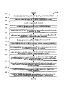
[0012] FIG. 1 is a flow diagram illustrating one embodiment of a method
for
implementing the present invention.
[0013] FIG, 2 is a block diagram illustrating one embodiment of a system
for
implementing the present invention.
DETAILED DESCRIPTION OF THE PREFERRED EMBODIMENTS
[0014] The subject matter of the present invention is described with
specificity,
however, the description itself is not intended to limit the scope of the
invention. The
subject matter thus, might also be embodied in other ways, to include
different steps
or combinations of steps similar to the ones described herein, in conjunction
with
other technologies. Moreover, although the term "step" may be used herein to
describe different elements of methods employed, the term should not be
interpreted
as implying any particular order among or between various steps herein
disclosed
unless otherwise expressly limited by the description to a particular order.
While the
following description refers to the oil and gas industry, the systems and
methods of
the present invention are not limited thereto and may also be applied in other
industries, such as water resource management, carbon sequestration, or
medical
imaging to achieve similar results.
Method Description
[0015] Referring now to FIG. 1, a flow diagram of one embodiment of a
method 100
for implementing the present invention is illustrated. The method 100 provides
a very
efficient way to easily convert, with high resolution, 3D seismic data and
associated
seismic attributes from a time domain to a depth domain for use in reservoir
studies.
- 5 -
SUBSTITUTE SHEET (RULE 26)
CA 02890187 2015-05-04
WO 2014/088571
PCT/US2012/067989
In the presence of structural overburden complexity, the time-migrated seismic
data
may be image-ray corrected using the method of Lamer, et al. (1981). The
method
100 incorporates one or more steps for training a multi-perception back-
propagation
artificial neural network to learn the interval transit times for each well in
the
reservoir study area. An artificial neural network is used for the purpose of
predicting
sonic logs from other logs related to the same well for wells where sonic logs
are not
available or are available but contaminated with unacceptable noise. The
artificial
neural network may be trained to predict sonic logs using wells that do have
good
sonic logs. The reasonable underlying assumption is that unknown lateral
variations
of the aitificial neural network coefficients would be insignificant within
the specific
reservoir interval of interest due to similarity in geology, burial history,
etc. and thus,
a single artificial neural network can be used for all of the wells. More than
one
artificial neural network, however, may be preferred.
[0016] In step 102, a seismic time horizon is selected within, or
immediately adjacent
to, a reservoir interval of interest using the client interface and/or the
video interface
described in reference to FIG. 2 and techniques well known in the art. The
reservoir
interval may be interpreted using the reservoir seismic data in order that the
seismic
time horizon may be identified and selected within, or immediately adjacent
to, the
reservoir interval of interest. The seismic time horizon may arise from a
reflection
from the top or base of the reservoir interval or a reflection from some other
layering
within, immediately above or immediately below the reservoir interval.
Alternatively,
a seismic depth horizon may be selected in the same manner with depth-migrated
seismic data instead of with time-migrated seismic data when in the presence
of
structural complexity in both the overburden and reservoir, The seismic depth
- 6 -
SUBSTITUTE SHEET (RULE 26)
CA 02890187 2015-05-04
WO 2014/088571
PCT/US2012/067989
horizon may be converted to a seismic time horizon using techniques well known
in
the art such as, for example, ray tracing or eikonal methods, while
maintaining the
well locations on the seismic time horizon.
[0017] In step 104, wells and associated well log data that intersect the
reservoir
interval of interest may be selected using the client interface and/or the
video interface
described in reference to FIG. 2.
[0018] In step 106, the well log data from the selected wells may be
processed using
well-known multi-variate statistical techniques to remove unreliable data
components,
like noise. The well log data may comprise, for example, available data from
open
hole or cased hole well log data.
[0019] In step 108, the well log depth picks (tops) may be converted to
depths along
the selected seismic time horizon using techniques well known in the art. The
depth of
the reflecting horizon corresponding to the selected seismic time horizon is
identified
in the wells and those depth picks may be interpolated and/or extrapolated
using
techniques such as kriging to provide a depth for every sampled location
within the
selected seismic time horizon.
[00201 In step 110, an artificial neural network may be trained and
validated using
interval transit times from sonic logs for the selected wells, the processed
well log
data and techniques well known in the art.
[0021] In step 112, interval transit times (proxy sonic logs) for the
selected wells
without valid sonic logs within and/or near the reservoir interval of interest
may be
predicted using the artificial neural network. The interval transit times
generated by
- 7 -
SUBSTITUTE SHEET (RULE 26)
CA 02890187 2015-05-04
WO 2014/088571
PCT/US2012/067989
the artificial neural network may be carefully analyzed and studied using well-
known
quality control techniques to confirm the level of accuracy required for each
interval
transit time.
[0022] In step 114, equal thneivariable depth (time-depth) pairs may be
produced for
each selected well in the reservoir interval of interest by numerically
integrating the
interval transit times from sonic logs for the selected wells and the interval
transit
times for the proxy sonic logs. The time origin for the integration is
established at the
depth of the selected seismic time horizon for each well location. The equal
time
increment is preferably that of the seismic data being analyzed, often 2
milliseconds,
although a finer increment may be chosen and the seismic data resampled to
that finer
increment to facilitate visualization and interpretation. The variable depth
reservoir
interval may be as small or as large as necessary. Care is taken to make small
adjustments as needed to ensure that the depths are consistent with available
geological horizon picks. In this manner, a highly accurate time-depth model
may be
developed that takes into account both the vertical variation and the lateral
variation at
an extremely detailed level. By comparison, other conventional techniques may
only
use as few as one well or one check-shot survey, resulting in an over-
simplified,
smoothed velocity model producing a time-depth relationship without the
necessary
detail.
[0023] In step 116, the time-depth pairs for all selected wells may be
converted to
time-depth pairs along the selected seismic time horizon using techniques well-
known
in the art.
- 8 -
SUBSTITUTE SHEET (RULE 26)
CA 02890187 2015-05-04
WO 2014/088571
PCT/US2012/067989
[0024] In step 118, a reference horizon is formed by realigning seismic
traces in a 3D
seismic volume (in time) so that the selected seismic time horizon appears at
time
zero on each trace. Each individual seismic trace in the seismic time volume
is shifted
up or down so that the selected seismic time horizon on each trace assumes a
new
constant time, For example, if on seismic trace (1)) the reference horizon
time is 2.14
seconds and the constant time is 1.96 seconds, then the entire seismic trace
would be
realigned by shifting upward 0.18 seconds. After each seismic trace gm is
processed,
the reference horizon will appear as a flat horizon aligned at 1.96 seconds on
every
seismic trace, At this point the reference horizon is the origin time for all
subsequent
depthing.
[0025] In step 120, a relative depth is assigned to each seismic sample
amplitude
value and associated seismic attribute value at or near the reservoir interval
of interest
using the converted time-depth pairs. If for example, the seismic data is
sampled at a
constant time step (e.g. 2 millisecond increments) and the reference horizon
is a 1.996
second horizontal slice, it is followed in time by a 1.998 time slice, a 2.000
second
time slice, etc. The subsurface distance between each horizontal slice is
generally not
a constant depth increment, but will generally vary from trace to trace and
time to
time. In the case of linear increase of velocity with depth, the depth steps
grow
exponentially with time. So if the horizon is at 1.996 seconds, the 1.998
second time
slice might correspond to a position 6 feet below the reference horizon and
the 2,000
second time slice to a position 15 feet below the reference horizon.
[0026] In step 122, multiple structurally con-ect surfaces representing
a time-depth
horizon volume may be formed by adding the depths along the selected seismic
time
horizon to the depths assigned to each seismic sample amplitude value and
associated
- 9 -
SUBSTITUTE SHEET (RULE 26)
CA 02890187 2015-05-04
WO 2014/088571
PCT/US2012/067989
seismic attribute value. In this manner, an absolute depth for each seismic
sample
amplitude value and associated seismic attribute value at and/or near the
reservoir
interval of interest may be determined. Each depth corresponds to a time-depth
pair
along the selected seismic time horizon and defines a structurally correct
surface in
depth. The collection of the multiple structurally correct surfaces define a
time-depth
horizon volume and bound a depth volume within the subsurface.
[0027] In step 124, each seismic sample amplitude value and associated
seismic
attribute value at or near the reservoir interval of interest may be
transferred from the
seismic time volume to the multiple structurally correct surfaces in the time-
depth
horizon volume using techniques well-known in the art such as, for example,
arithmetic (mean, closest to node, median, average, etc.) methods, geometric
methods,
or geostatistical methods. In this manner, the seismic time volume and the
time-depth
horizon volume are colocated. Preferably, the seismic attributes are
transferred from
the seismic time volume to the multiple structurally correct surfaces in the
time-depth
horizon volume using the value closest to the horizon sample location as it
appears to
be statistically the most accurate. Additionally, when the selected seismic
time
horizon has significant structural complexity prior to realigning, it is
preferable to
recompute seismic attributes in a direction most perpendicular to that surface
as
described in US Patent No, 7,702,463 prior to transferring them to the
multiple
structurally correct surfaces,
[0028] In step 126, a 3D geocellular model may be constructed that
contains the
time-depth horizon volume using the multiple structurally correct surfaces and
techniques well-known in the art such as those embodied in commercial software
packages such as Landmark Graphics Corporation's DecisionSpace , Desktop.
- I 0 -
SUBSTITUTE SHEET (RULE 26)
CA 02890187 2015-05-04
WO 2014/088571
PCT/US2012/067989
[0029] In step 128, each seismic sample amplitude value and associated
seismic
attribute value from the structurally correct surfaces in the time-depth
horizon volume
may be transferred to the 3D geocellular model using techniques well known in
the
art. Because each seismic attribute value is in the depth domain and perfectly
collocated with the reservoir well interval, engineering data and micro-
seismic
information, the 3D geocellular model may be used in reservoir and/or other
oil and
gas characterization studies as well as horizontal well planning in
unconventional
reservoirs. Additional benefits may include, for example, use of the results
for
designing well stimulation, micro-seismic detection (fault detection) and
wireline
logging.
System Description
[0030] The present invention may be implemented through a computer-
executable
program of instructions, such as program modules, generally referred to
software
applications or application programs executed by a computer. The software may
include, for example, routines, programs, objects, components and data
structures that
perform particular tasks or implement particular abstract data types. The
software
forms an interface to allow a computer to react according to a source of
input.
DecisionSpace Desktop Earth Modeling, which is a commercial software
application marketed by Landmark Graphics Corporation, may be used as an
interface
application to implement the present invention. The software may also
cooperate
with other code segments to initiate a variety of tasks in response to data
received in
conjunction with the source of the received data. Other code segments may
provide
optimization components including, but not limited to, neural networks, earth
modeling, history matching, optimization, visualization, data management,
reservoir
- 11 -
SUBSTITUTE SHEET (RULE 26)
CA 02890187 2015-05-04
WO 2014/088571
PCT/US2012/067989
simulation and economics. The software may be stored and/or carried on any
variety
of memory such as CD-ROM, magnetic disk, bubble memory and semiconductor
memory (e.g., various types of RAM or ROM). Furthermore, the software and its
results may be transmitted over a variety of carrier media such as optical
fiber,
metallic wire, and/or through any of a variety of networks, such as the
Internet.
[0031] Moreover, those skilled in the art will appreciate that the
invention may be
practiced with a variety of computer-system configurations, including hand-
held
devices, multiprocessor systems, microprocessor-based or programmable-consumer
electronics, minicomputers, mainframe computers, and the like. Any number of
computer-systems and computer networks are acceptable for use with the present
invention. The invention may be practiced in distributed-computing
environments
where tasks are performed by remote-processing devices that are linked through
a
communications network. In a distributed-computing environment, program
modules
may be located in both local and rerribte computer-storage media including
memory
storage devices. The present invention may therefore, be implemented in
connection
with various hardware, software or a combination thereof, in a computer system
or
other processing system.
[0032] Referring now to FIG. 2, a block diagram illustrates one
embodiment of a
system for implementing the present invention on a computer. The system
includes a
computing unit, sometimes referred to as a computing system, which contains
memory, application programs, a client interface, a video interface, and a
processing
unit. The computing unit is only one example of a suitable computing
environment
and is not intended to suggest any limitation as to the scope of use or
functionality of
the invention.
- 12 -
SUBSTITUTE SHEET (RULE 26)
CA 02890187 2015-05-04
WO 2014/088571
PCT/US2012/067989
[0033] The memory primarily stores the application programs, which may
also be
described as program modules containing computer-executable instructions,
executed
by the computing unit for implementing the present invention described herein
and
illustrated in FIG. 1. The memory therefore, includes a 3D seismic data depth
conversion module, which enables the methods illustrated and described in
reference
to FIG, 1 and integrates functionality from the remaining application programs
illustrated in FIG. 2. The memory also includes DecisionSpace Desktop Earth
Modeling, which may be used as an interface application to supply well log
input data
to the 3D seismic data depth conversion module and/or display the data results
from
the 3D seismic data depth conversion module. Although DecisionSpace Desktop
Earth Modeling may be used as an interface application, other interface
applications
may be used, instead, or the 3D seismic data depth conversion module may be
used as
a stand-alone application.
[0034] Although the computing unit is shown as having a generalized
memory, the
computing unit typically includes a variety of computer readable media. By way
of
example, and not limitation, computer readable media may comprise computer
storage media and communication media. The computing system memory may
include computer storage media in the form of volatile and/or nonvolatile
memory
such as a read only memory (ROM) and random access memory (RAM). A basic
input/output system (BIOS), containing the basic routines that help to
transfer
information between elements within the computing unit, such as during start-
up, is
typically stored in ROM, The RAM typically contains data and/or program
modules
that are immediately accessible to, and/or presently being operated on, the
processing
- 13 -
SUBSTITUTE SHEET (RULE 26)
CA 02890187 2015-05-04
WO 2014/088571
PCT/1JS2012/067989
unit. By way of example, and not limitation, the computing unit includes an
operating
system, application programs, other program modules, and program data.
[0035] The components shown in the memory may also be included in other
removable/nonremovable, volatile/nonvolatile computer storage media or they
may be
implemented in the computing unit through an application program interface
("API")
or cloud computing, which may reside on a separate computing unit connected
through a computer system or network. For example only, a hard disk drive may
read
from or write to nonremovable, nonvolatile magnetic media, a magnetic disk
drive
may read from or write to a removable, nonvolatile magnetic disk, and an
optical disk
drive may read from or write to a removable, nonvolatile optical disk such as
a CD
ROM or other optical media. Other removable/non-removable,
volatile/nonvolatile
computer storage media that can be used in the exemplary operating environment
may
include, but are not limited to, magnetic tape cassettes, flash memory cards,
digital
versatile disks, digital video tape, solid state RAM, solid state ROM, and the
like.
The drives and their associated computer storage media discussed above provide
storage of computer readable instructions, data structures, program modules
and other
data for the computing unit.
[0036] A client may enter commands and information into the computing
unit
through the client interface, which may be input devices such as a keyboard
and
pointing device, commonly referred to as a mouse, trackball or touch pad.
Input
devices may include a microphone, joystick, satellite dish, scanner, or the
like. These
and other input devices are often connected to the processing unit through the
client
interface that is coupled to a system bus, but may be connected by other
interface and
bus structures, such as a parallel port or a universal serial bus (US3).
- 14 -
SUBSTITUTE SHEET (RULE 26)
CA 02890187 2016-11-15
[0037] A monitor or other type of display device may be connected to the
system
bus via an interface, such as a video interface. A graphical user interface
("GUI")
may also be used with the video interface to receive instructions from the
client
interface and transmit instructions to the processing unit. In addition to the
monitor, computers may also include other peripheral output devices such as
speakers and printer, which may be connected through an output peripheral
interface.
[0038] Although many other internal components of the computing unit are
not
shown, those of ordinary skill in the art will appreciate that such components
and
their interconnection are well-known.
[0039] While the present invention has been described in connection with
presently preferred embodiments, it will be understood by those skilled in the
art
that it is not intended to limit the invention to those embodiments. It is
therefore,
contemplated that various alternative embodiments and modifications may be
made to the disclosed embodiments without departing from the scope of the
invention defined by the appended claims and equivalents thereof.
- 15-