Note: Descriptions are shown in the official language in which they were submitted.
CA 02895949 2015-05-08
WO 2014/072811 PCT/1B2013/002627
1
METHOD OF PROCESSING SEISMIC IMAGE OF THE SUBSURFACE
BACKGROUND OF THE INVENTION
The present invention relates to the processing of images of the subsurface
and
especially to the transformation of seismic images into chrono-stratigraphic
representations.
The approaches described in this section could be pursued, but are not
necessarily approaches that have been previously conceived or pursued.
Therefore,
unless otherwise indicated herein, the approaches described in this section
are not
prior art to the claims in this application and are not admitted to be prior
art by
inclusion in this section. Furthermore, all embodiments are not necessarily
intended
to solve all or even any of the problems brought forward in this section.
It is known, especially in oil exploration, to determine the position of oil
reservoirs
from the results of geophysical measurements carried out from the surface or
in well
bores. According to the technology of reflection seismology, these
measurements
involve emitting a wave (acoustic waves or electromagnetic radiation) into the
subsurface and measuring a signal comprising a plurality of echoes of the wave
on
geological structures being investigated. These structures are typically
surfaces
separating distinct materials, faults, etc. Other measurements are carried out
from
wells.
Chrono-stratigraphic analysis (sequence stratigraphic analysis) is very
important to
understand basin evolution, predict the sedimentary facies distribution for
both
petroleum exploration and development. This analysis is based on the
fundamental
assumption that seismic reflectors are surfaces of chrono-stratigraphic
significance.
This assumption implies that an individual seismic reflector is a "time-line"
through a
depositional basin that represents a surface of the same geologic age. Faults
are
excluded from this definition.
A seismic cross section is formed by the juxtaposition in a plane of sampled
one-
CA 02895949 2015-05-08
WO 2014/072811 PCT/1B2013/002627
2
dimensional signals referred to as seismic traces (2D). Likewise, a seismic
block is
formed by the juxtaposition of seismic traces in a volume (3D seismic image).
The
expression "seismic image" refers either to a seismic cross section or a
seismic
block.
In a seismic image, the luminous intensity of a pixel is proportional to the
seismic
magnitude represented by one-dimensional signals.
Computing a chrono-stratigraphic representation of a seismic image often
requires, in regard of the previous methods, the synthesis of seismic horizons
in the
cross section or the block.
Several methods have been devised for carrying out syntheses of horizons. For
instance, the thesis by Marc Donias, submitted on Jan. 28, 1999 to the
University of
Bordeaux I and entitled "Caracterisation de champs d'orientation par analyse
en
composantes principales et estimation de la courbure. Application aux images
sismiques, [Characterization of orientation fields by principal components
analysis
and estimation of curvature. Application to seismic images]", describes in
detail
possible schemes for carrying out horizon synthesis. The patent US 6 771 800
B1
also describes a possible method to create chrono-stratigraphic interpretation
of a
seismic image.
Such methods have drawbacks especially if the resolution of the seismic image
is
very low or contains a high noise level. In such case, computed horizons of
the
seismic images may be erroneous and thus may provide inadequate results. In
addition, these methods may be erroneous if the assumption that seismic
reflectors
are surfaces of chrono-stratigraphic significance is false.
There is thus a need for improving the computation chrono-stratigraphic
representation in such cases.
SUMMARY OF THE INVENTION
The invention relates to a method of processing seismic image of the
subsurface,
said seismic image comprising pixels, each pixel having a color value.
The method comprises:
CA 02895949 2015-05-08
WO 2014/072811 PCT/1B2013/002627
3
- determining a first surface and a second surface in the seismic image,
the
first surface and the second surface being determined based on geological
information extracted from well data from at least one well in the subsurface;
- determining first dip components for pixels of the first surface and
second dip
components for pixels of the second surface;
- for each pixel of the seismic image between the first surface and the
second
surface, determining interpolated dip components based on at least the first
dip components and the second dip components.
- for each pixel of the seismic image between the first surface and the
second
surface, determining an interpolated surface based on at least the
interpolated dip components for pixels between the first surface and the
second surface;
- for each current pixel of the seismic image between the first surface and
the
second surface, determining a density value based on a number of
intersections of the determined surfaces with a column comprising said
current pixel, said intersections being below said pixel in said column;
- determining a geological-time image, columns of said geological-time
image
is computed based:
- on the density values of pixels of a corresponding column of the
seismic image;
- on the color value of pixels of the corresponding column of the
seismic image.
A "surface" may be a 1D curve (if the seismic image is a 2D image) and a 2D
surface (if the seismic image is a 3D image).
"Geological information" is a piece of information based on geological
considerations. A seismic image does contains any geological information
extracted
from well data as the seismic image may be computed based on acoustic signals,
without the need of any wells.
The "dip components" of a pixel are related to the components of local
gradient for
CA 02895949 2015-05-08
WO 2014/072811 PCT/1B2013/002627
4
said pixels (e.g. the local gradient of the luminous intensity at said pixel).
For instance, a given pixel is between a first surface and a second surface if
there
is a line connecting a pixel of the first surface and a pixel of the second
surface, said
line comprising said given pixel.
The determined interpolated surface T may be based on calculating a non-linear
partial derivative equation based on the interpolated dip p:
VT (x,y,t) = p(x,y,t + T (x, y, t))
Therefore, it is possible to determine a geological-time representation even
if the
seismic layers of the seismic image do not provide an accurate time
representation of
the subsurface (i.e. if the seismic reflectors are not surfaces of chrono-
stratigraphic
significance).
In addition, the method may further comprise:
- receiving a first well data associated with points of a first well and a
second
well data associated with points of a second well;
- identifying a first point in the first well and a second point in the second
well,
the first point and the second point having a same identified relative time in
said well data.
Said first surface may comprise the first point and the second point.
In a possible embodiment, the first surface may be determined based on a
regression algorithm. In addition, said surface may be determined based on a
trend
map determined an operator, and thus received.
It is possible that all identified points cannot be on a surface determined by
the
determination algorithm (e.g. over-determined systems). Thus, it is possible
to
determine the surface that minimizes the sum of the squares of the errors made
in
the results (least square method).
CA 02895949 2015-05-08
WO 2014/072811 PCT/1B2013/002627
In addition, the interpolated dip components may be computed based on a
multivariate interpolation, the interpolation being known for dip components
at pixels
on the first surface and at pixels of the second surface.
5
A second aspect relates to a computer program product comprising a computer
readable medium, having thereon a computer program comprising program
instructions. The computer program is loadable into a data-processing unit and
adapted to cause the data-processing unit to carry out the method described
above
when the computer program is run by the data-processing unit.
A third aspect relates to a device for processing seismic image of the
subsurface,
said seismic image comprising pixels, each pixel having a color value.
The device comprises:
- a circuit for determining a first surface and a second surface in the
seismic
image, the first surface and the second surface being determined based on
geological information extracted from well data from at least one well in the
subsurface;
- a circuit for determining first dip components for pixels of the first
surface and
second dip components for pixels of the second surface;
- for each pixel of the seismic image between the first surface and the
second
surface, a circuit for determining interpolated dip components based on at
least the first dip components and the second dip components.
- for each pixel of the seismic image between the first surface and the
second
surface, a circuit for determining an interpolated surface based on at least
the
interpolated dip components for pixels between the first surface and the
second surface;
- for each current pixel of the seismic image between the first surface and
the
CA 02895949 2015-05-08
WO 2014/072811 PCT/1B2013/002627
6
second surface, a circuit for determining a density value based on a number
of intersections of the determined surfaces with a column comprising said
current pixel, said intersections being below said pixel in said column;
- a circuit for determining a geological-time image, columns of said
geological-
time image is computed based:
- on the density values of pixels of a corresponding column of the
seismic image;
- on the color value of pixels of the corresponding column of the
seismic image.
Other features and advantages of the method and apparatus disclosed herein
will
become apparent from the following description of non-limiting embodiments,
with
reference to the appended drawings.
BRIEF DESCRIPTION OF THE DRAWINGS
The present invention is illustrated by way of example, and not by way of
limitation, in the figures of the accompanying drawings, in which like
reference
numerals refer to similar elements and in which:
- Figure la is a possible seismic image;
- Figure 1 b is a possible chrono-stratigraphic representation of the
seismic
image of Figure la;
- Figure 2 is a representation of a determination of a surface according to
a
possible embodiment of the present invention;
- Figure 3 is a flow chart describing a possible embodiment of the present
invention;
- Figure 4 is a possible embodiment for a device that enables the present
invention.
DESCRIPTION OF PREFERRED EMBODIMENTS
CA 02895949 2015-05-08
WO 2014/072811 PCT/1B2013/002627
7
Figure la is a possible seismic image 100. This image is a 2D section of a
seismic
image. It represents a picture of the subsoil arising from a seismic
exploration survey.
The image section 100 comprises two dimensions: it is defined by a horizontal
extension along a horizontal axis.i.' and by a vertical extension along a
vertical axis 5;
in the direction of the subsoil. The image section 100 is composed of pixels
regularly
distributed according to a horizontal pitch on the horizontal axis and a
vertical pitch
on the vertical axis. The seismic image 100 comprises:
- a number of columns of pixels which is equal to the quotient of the
horizontal
extension divided by the horizontal pitch, and
- a number of pixels per column which is equal to the quotient of the vertical
extension divided by the vertical pitch.
Most of the time, pixels are associated with a color value (gray value)
between 0
and 255 (or 65535). The color values are often based on the amplitude of a
seismic
signal associated with said image (e.g. high amplitude would be manifested by
a
bright pixel and low amplitude by a dark pixel).
In particular, the vertical black line 105 represents a column of pixels.
To implement the method according to the invention, it is possible to define a
matrix M (or density matrix/map) which has the same dimensions of the image
100:
- the number of rows of the matrix M is equal to the number of pixels in a
column of the image 100 and
- the number of columns of the matrix M is equal to the number of columns
of
the image 100 (i.e. the number of pixels in a line).
The matrix M thus consists of as many elements as there are pixels in the
image
100 and each element is associated with a pixel of the image 100. All the
elements of
the matrix M are integers (or floating numbers) initially having a zero value.
For some pixels of the image 100 (preferably each pixel), it is possible to
compute
a curve coming through the pixel and transverse to the vertical dimension of
the
image section 100 (extend from one side 110 of the seismic image to the
opposite
side 111 of the seismic image). The calculation of this curve may involve
calculating
CA 02895949 2015-05-08
WO 2014/072811 PCT/1B2013/002627
8
a local gradient p (or a local dip) of the luminous intensity at said pixel.
Said
dip/gradient may be provided by an input matrix (pre-computed matrix) or may
be
computed directly based on the seismic image 100. The gradient may have a
vertical
component and a horizontal component.
The computed curves (e.g. 101, 102, 103, 104) are also known as "horizons" or
"seismic horizons". The computation of said horizons T deal with a non-linear
partial
derivative equation based on local dip p estimated from the seismic image to
evaluate iteratively the horizon. Thus the horizon T verifies the following
formula:
VT (x,y,t) = p(x,y,t + T (x, y, t))
Some other possible computations of said horizons are described in patent US
6,771,800 B1 or in application FR1158947.
Once the horizons are computed, it is possible to determine the values of the
matrix M. For each pixel of the seismic image, it is possible to determine a
density
value as the number of intersections of the horizons with the column
comprising said
pixel, said intersections being below said pixel in said column. Said density
value is
stored in the matrix M at same coordinates as said pixel.
For instance, for pixel 106, the density value is 0 as there is no
intersection of the
column 105 and the computed horizon 101, 102, 103, 104 below the pixel 106
(i.e.
an intersection having the y coordinate less than the y coordinate of pixel
106).
For pixel 107, the density value is 2 as there is two intersections of the
column 105
and the computed horizon 101, 102, 103, 104 below the pixel 107 (i.e. an
intersection
having the y coordinate less than the y coordinate of pixel 107): these
intersections
are the intersections of horizons 103 and 104 with the column 105.
For pixel 108, the density value is 4 as there is four intersections of the
column
105 and the computed horizon 101, 102, 103, 104 below the pixel 108 (i.e. an
intersection having the y coordinated less than the y coordinate of pixel
108): these
intersections are the intersections of horizons 101, 102, 103 and 104 with the
column
105.
It is possible to interpolate the density value of a pixel in a given column
and
CA 02895949 2015-05-08
WO 2014/072811 PCT/1B2013/002627
9
between two computed curves. This interpolation is based on the density value
corresponding to the two pixels on the intersections of said two curves with
said
column. This computation may take in account the distance of the pixel with
the
intersections. For instance:
DV = DV1* D1+ DV2 * D2
D1+ D2
with DV the density value corresponding to the current pixel, DV1 the density
value corresponding to the pixel of the first intersection, DV2 the density
value
corresponding to the pixel of the second intersection, D1 the distance between
the
pixel and the pixel of the first intersection, D2 the distance between the
pixel and the
pixel of the second intersection.
Figure lb is a possible chrono-stratigraphic representation of the seismic
image of
Figure la.
The chrono-stratigraphic representation 150 is computed based on the density
matrix and the seismic image. For instance, the chrono-stratigraphic
representation
(which is an image of the same dimensions of the seismic image) is computed
column by column.
For a pixel i of a current column c in the chrono-stratigraphic
representation, a
color value is associated with said pixel according the following formula:
Si [c; i] = CS rm[c; i] 'max 1
[ mmax
with SI[x;y] the color value of the seismic image at coordinates (x,y),
CS[x;y] the
color value of the chrono-stratigraphic representation at coordinates (x,y),
M[x,y] the
density value in the matrix M at coordinates (x,y), Mmax the maximum density
value
(which may be M(1,1) if (1,1) is the coordinates of the top left pixel in the
seismic
image), and Imax is the height of the seismic image (in pixel).
The horizons 101, 102, 103, 104 are thus transformed into horizontal lines
respectively 151, 152, 153, 154 (as the density values of pixels on these
horizons are
CA 02895949 2015-05-08
WO 2014/072811 PCT/1B2013/002627
constant)
It may happen that some pixels of the chrono-stratigraphic representation may
not
be defined according the above formula: these zones of pixels are identified
as
"hiatus" (a zone of the subsoil that lacks of deposit or reflects an erosion
5 phenomenon, e.g. 155a, 155b, 155c, 155d, 155e).
Figure 2 is a representation of a determination of a surface according to a
possible
embodiment of the present invention.
If the amplitude of a seismic signal may provide useful information on the
time of
10 sedimentation of the layer but it is possible that this information is
erroneous: for
instance, it is possible that during a same sedimentation process heavy
deposits are
transported to a given point when light deposits are transported to another
point (for
instance for "delta" sedimentation, alluvial fan, etc.). Therefore, the
assumption that
seismic reflectors are surfaces of chrono-stratigraphic significance is false
in such
cases. Even if the depositions do not have the same composition (and thus a
different appearance on the seismic image) the relative time of the
sedimentation are
the same.
Thus, the only seismic information is not sufficient to create a reliable
chrono-
stratigraphic representation. In order to mitigate this issue, geologists may
tag
specific points on the seismic image with a time value that they may be able
to
determine (either thanks to their knowledge of the subsoil or thanks to well
data that
may be issued from wells and that is interpreted).
For instance, vertical lines 202, 203 and 204 may represent vertical well in
the
subsoil. The surface 201 may represent the automatically computed horizon
based
on the dip of the seismic image as described above.
Geologists may, based on the well data, determine that points 205, 206 and 207
(respectively in wells 202, 203 and 204) of the seismic image have same
relative time
i.e. same sedimentation time (for instance by analyzing pieces of rocks
according to
Carbon-14 dating method or by grasping the overall sedimentation process).
CA 02895949 2015-05-08
WO 2014/072811 PCT/1B2013/002627
11
Thus, it is possible to determine a new surface 208 that comes through all
these
points, geologists may provide/use trend maps that they have established
thanks to
their knowledge of the subsoils. This determination may also use a simple
regression
algorithm such as a linear regression, a polynomial regression, logistic
regression,
multinomial regression, etc. based on the points 205, 206, 207.
Once the surface 208 is determined, it is possible to determine a local dip
208 for
points
f
,or
points of said surface 208 (for instance, for all points along the surface).
This local dip
P208 represents a unit vector, perpendicular to the surface.
A surface 209 may be determined based on the above proposed algorithm.
Once this surface 209 is determined, a local dip P209 may also be determined
for
points of said surface 209.
Thanks to all determined local dips P208 and P209, it is possible to determine
an
interpolated local dip Pinter for each point between these two surfaces 208
and 209
thanks to a 2D interpolation (if the seismic image is 2D) or a 3D
interpolation (if the
seismic image is 3D).
Thanks to this new dip p (i.e. the union of P208, P209, Pinter), it is
possible to
determine as many horizons as wished between the surface 208 and the surface
209
(e.g. for each points between the surface 208 and the surface 209) as detailed
above
in relation of Figure la.
Therefore, a density map M may be determined for points between surfaces 208
and 209 as detailed above in relation of Figure la.
Finally, a determination of the chrono-stratigraphic representation (of at
least the
subsoil zone between surfaces 208 and 209) is possible described above.
In such embodiement, the chrono-stratigraphic representation is not computed
thanks to horizon computations (i.e. issued from the seismic image).
There is no requirement that the surface 208 and the cur surface ve 209 is
defined
from one side 210 of the seismic image to an opposite side 211. For instance,
a
surface 212 may be determined (based on the above proposed algorithm) even if
it
does not extends across the seismic image.
CA 02895949 2015-05-08
WO 2014/072811 PCT/1B2013/002627
12
In such case, a local dip P212 may also be determined for points of said
surface
212. Then, the dip interpolation for points between surface 209 and surface
208 is
constrained by the local dip P212.
The interpolation of the local dip p may be a bilinear interpolation (2D case)
or a
trilinear interpolation (3D case), each component of the local dip being
independently
computed.
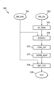
Figure 3 is a flow chart describing a possible embodiment of the present
invention.
The seismic image 301 comprises pixels, each pixel having a color value.
Upon reception of well data (302) from at least one well in the subsurface, it
is
possible to determine (step 303) different points of said well data having a
same
relative sedimentation time: the sedimentation time may be provided thanks to
geological information extracted/calculated from well data. Thus, it is
possible to
determine (step 304) at least one surface in the seismic image. The surface is
determined thanks to the determined points having the same relative
sedimentation
time and thanks, if they are available, to trend maps that geologists may
establish.
Regression algorithm may ease the determination of such surface. This
determination is described in relation of Figure 2.
Thanks to the determined surfaces, it is possible to create (step 305) a dip
map as
described above.
Thus, it is possible to determine (step 307) a plurality of surfaces based on
the
created dip map and then, to determine a density map: for each current pixel
of the
seismic image, a density value is determined based on a number of
intersections of
the determined surfaces (or the combined curved if the steps 305 and 306 are
executed) with a column comprising said current pixel. The considered
intersections
are below said pixel in said column.
Thanks to the determined density map (or density matrix), it is possible to
transform the received seismic image (301) into a chrono-stratigraphic
representation
CA 02895949 2015-05-08
WO 2014/072811 PCT/1B2013/002627
13
(step 308) as described in relation of Figure lb and based on based on the
density
values of pixels of a corresponding column of the seismic image and on the
color
value of pixels of the corresponding column of the seismic image.
Finally, the chrono-stratigraphic representation/image (309) may be outputted
for
further processing or interpretation(s).
Part of this flow chart can represent steps of an example of a computer
program
which may be executed by the device of Figure 4.
Figure 4 is a possible embodiment for a device that enables the present
invention.
In this embodiment, the device 400 comprise a computer, this computer
comprising a memory 405 to store program instructions loadable into a circuit
and
adapted to cause circuit 404 to carry out the steps of the present invention
when the
program instructions are run by the circuit 404.
The memory 405 may also store data and useful information for carrying the
steps
of the present invention as described above.
The circuit 404 may be for instance:
- a processor or a processing unit adapted to interpret instructions in a
computer language, the processor or the processing unit may comprise, may
be associated with or be attached to a memory comprising the instructions,
or
- the association of a processor / processing unit and a memory, the
processor
or the processing unit adapted to interpret instructions in a computer
language, the memory comprising said instructions, or
- an electronic card wherein the steps of the invention are described
within
silicon, or
- a programmable electronic chip such as a FPGA chip (for Field-
Programmable Gate Array .).
This computer comprises an input interface 403 for the reception of the
seismic
CA 02895949 2015-05-08
WO 2014/072811 PCT/1B2013/002627
14
image and of the well data according to the invention and an output interface
406 for
providing a chrono-stratigraphic representation of the seismic image.
To ease the interaction with the computer, a screen 401 and a keyboard 402 may
be provided and connected to the computer circuit 404.
Expressions such as "comprise", "include", "incorporate", "contain", "is" and
"have"
are to be construed in a non-exclusive manner when interpreting the
description and
its associated claims, namely construed to allow for other items or components
which
are not explicitly defined also to be present. Reference to the singular is
also to be
construed in be a reference to the plural and vice versa.
A person skilled in the art will readily appreciate that various parameters
disclosed
in the description may be modified and that various embodiments disclosed may
be
combined without departing from the scope of the invention.
For instance, all the figures are presented in 2-dimensions. Nevertheless, it
is
apparent that the seismic images may be 3D images and thus, the surfaces or
horizons or curves may be two-dimensional, topological manifold.