Note: Descriptions are shown in the official language in which they were submitted.
CA 02896425 2015-07-06
.74769-1261D1
1
METHOD AND APPARATUS FOR WIRELESS NETWORK HYBRID
POSITIONING
This is a divisional of Canadian National Phase Patent Application Serial
No. 2,530,892 filed on June 28, 2004.
[0001]
This application is related to and claims the benefit of U.S. Provisional
Patent
Application Serial No 60/483,094, filed June 27, 2003.
FIELD OF THE INVENTION
[0002]
The invention relates to position determination systems, and more particularly
to
hybrid positioning using wireless communication signals.
BACKGROUND
[0003]
To perform position location in wireless cellular networks (e.g., a cellnlar
telephone network), several approaches perform trilateration based upon the
use of timing
information sent between each of several base stations and a mobile device,
such as a cellular
telephone. One approach, called Advanced Forward Link Trilateration (AFLT) in
CDMA or
Enhanced Observed Time Difference (EOTD) in GSM or Observed Time Difference of
Arrival (OTDOA) in WCDMA, measures at the mobile device the relative times of
arrival of
signals transmitted from each of several base stations. These times are
transmitted to a
Location Server (e.g., a Position Determination Entity (PDE) in CDMA), which
computes the
position of the mobile device using these times of reception. The transmit
times at these base
stations are coordinated such that at a particular instance of time, the times-
of-day associated
with multiple base stations are within a specified error bound. The accurate
positions of the
base stations and the times of reception are used to determine the position of
the mobile
device.
[0004]
Figure 1 shows an example of an AFLT system where the times of reception
=
(1R1, TR2, and TR3) of signals from cellular base stations 101, 103, and 105
are measured at
the mobile cellular telephone 111. This timing data may then be used to
compute the position
of the mobile device. Such computation may be done at the mobile device
itself, or at a
CA 02896425 2015-07-06
' 74769-1261D2
2
location server if the timing infoiination so obtained by the mobile device is
transmitted to the
location server via a communication link. Typically, the times of receptions
are
communicated to a location server 115 through one of the cellular base
stations (e.g., base
station 101, or 103, or 105). The location server 115 is coupled to receive
data from the base
stations through the mobile switching center 113. The location server may
include a base
station almanac (BSA) server, which provides the location of the base stations
and/or the
coverage area of base stations. Alternatively, the location server and the BSA
server may be
separate from each other; and, the location server communicates with the base
station to
obtain the base station almanac for position determination. The mobile
switching center 113
provides signals (e.g., voice communications) to and from the land-line Public
Switched
Telephone Network (PSTN) so that signals may be conveyed to and from the
mobile
telephone to other telephones (e.g., land-line phones on the PSTN or other
mobile telephones).
. In some cases the location server may also communicate with the mobile
switching center via
a cellular link. The location server may also monitor emissions from several
of the base
stations in an effort to determine the relative timing of these emissions.
[0005] In another approach, called Uplink Time of Arrival (UTOA), the
times of
reception of a signal from a mobile device is measured at several base
stations (e.g.,
measurements taken at base stations 101, 103 and 105). Figure 1 applies to
this case if the
arrows of TRI, TR2, and TR3 are reversed. This timing data may then be
communicated to
the location server to compute the position of the mobile device.
[00061 Yet a third method of doing position location involves the use in
the mobile device
of circuitry for the United States Global Positioning Satellite (GPS) system
or other Satellite
Positioning Systems (SPS), such as the Russian GLONASS system and the proposed
European Galileo System, or a combination of satellites and pseudolites.
Pseudolites are
ground-based transmitters, which broadcast a PN code (similar to a GPS signal)
modulated on
an L-band carrier signal, generally synchronized with SPS time. Each
transmitter may be
assigned a unique PN code so as to permit identification by a mobile device.
Pseudolites are
CA 02896425 2015-07-06
74769-1261D2
3
useful in situations where SPS signals from an orbiting satellite might be
unavailable, such as
tunnels, mines, buildings or other enclosed areas. The term "satellite", as
used herein, is
intended to include pseudolite or equivalents of pseudolites, and the term GPS
signals, as used
herein, is intended to include GPS-like signals from pseudolites or
equivalents of pseudolites.
Methods which use an SPS receiver to determine a position of a mobile station
may be
completely autonomous (in which the SPS receiver, without any assistance,
determines the
position of the mobile station) or may utilize the wireless network to provide
assistance data
or to share in the position calculation. Examples of such methods are
described in U.S. Patents
6,208,290; 5,841,396; 5,874,914; 5,945,944; and 5,812,087. For instance, U.S.
Patent No.
5,945,944 describes, among other things, a method to obtain from cellular
phone transmission
signals accurate time information, which is used in combination with SPS
signals to determine
the position of the receiver; U.S. Patent No. 5,874,914 describes, among other
things, a
method to transmit the Doppler fiequency shifts of in view satellites to the
receiver on the
mobile device through a communication link to determine the position of the
mobile device;
U.S. Patent No. 5,874,914 describes, among other things, a method to transmit
satellite
almanac data (or ephemeris data) to a receiver through a communication link to
help the
receiver to determine its position; U.S. Patent No. 5,874,914 also describes,
among other
things, a method to lock to a precision carrier frequency signal of a cellular
telephone system
to provide a reference signal at the receiver for SPS signal acquisition; U.S.
Patent No.
6,208,290 describes, among other things, a method to use an approximate
location of a
receiver to determine an approximate Doppler for reducing SPS signal
processing time; and,
U.S. Patent No. 5,812,087 describes, among other things, a method to compare
different
records of a satellite data message received to determine a time at which one
of the records is
received at a receiver in order to determine the position of the receiver. In
practical low-cost
implementations, both the mobile cellular communications receiver and the SPS
receiver are
integrated into the same enclosure and, may in fact share common electronic
circuitry.
[0007] In
yet another variation of the above methods, the round trip delay (RID) is
found
CA 02896425 2015-07-06
' 74769-1261D2
4
for signals that are sent from the base station to the mobile device and then
are returned. In a
similar, but alternative, method the round trip delay is found for signals
that are sent from the
mobile device to the base station and then returned. Each of these round-trip
delays is divided
by two to determine an estimate of the one-way propagation delay. Knowledge of
the location
of the base station, plus a one-way delay constrains the location of the
mobile device to a
circle on the earth. Two such measurements from distinct base stations then
result in the
intersection of two circles, which in cum constrains the location to two
points on the earth. A
third measurement (even an angle of arrival or cell sector identification)
resolves the
ambiguity.
[0008] A combination of either the AFLT or -U-11)0A with an SPS system may
be
referred to as a ''hybrid" system. For example, U.S. Patent No. 5,999,124
describes, among
other things, a hybrid system, in which the position of a cell based
transceiver is determined
from a combination of at least: i) a time measurement that represents a time
of travel of a
message in the cell based coramunication signals between the cell based
transceiver and a
communication system; and, ii) a time measurement that represents a time of
travel of an SPS
signal.
[00091 Altitude aiding has been used in various methods for determining the
position of a
mobile device. Altitude aiding is typically based on a pseudo-measurement of
the altitude.
The knowledge of the altitude of a location of a mobile device constrains the
possible
positions of the mobile device to a surface of a sphere (or an ellipsoid) with
its center located
at the center of the earth. This knowledge may be used to reduce the number of
independent
measurements required to determine the position of the mobile device. For
example, U.S.
Patent No. 6,061,018 describes, among other things, a method where an
estimated altitude is
determined from the information of a cell object, which may be a cell site
that has a cell site
transmitter in communication with the mobile device.
CA 02896425 2015-07-06
= 74769-1261D2
SUMMARY OF THE DESCRIPTION
[0010] Methods and apparatuses for hybrid position determination and/or
other types of
operations with communication signals are described here. Some of the
embodiments of the
present invention are summarized in this section.
[0011] In one aspect of the present invention, a mobile station uses
wireless signals from a
plurality of different wireless networks' (e.g., with different air
interfaces, core technologies
and/or operated by different service providers) for position determination
(e.g., for data
communication, for obtaining time and/or frequency information, for
positioning
measurement, for sector or altitude estimation). In certain other aspects of
the present
invention, mobile stations are used to harvest statistical data about wireless
access points (e.g.,
the locations of mobile stations that have received signals from the wireless
access points,
such as from cellular base stations, wireless local area network access
points, personal area
communication transmitters, repeaters or beacons for positioning signals, or
other wireless
communication transmitters) and to derive location information (e.g., position
and/or coverage
area of the wireless transmitters, wireless transmitter identification
information such as a
SID/NID/BASE-ID, MSC-1D, IP address, MAC address, logical name, etc) for the
wireless
networks from the collected statistical data. Note that, in the present
application, wireless
transmitters are normally ground based transmitters as opposed to orbiting
satellites which are
transmitters.
[0012] In one aspect of the invention, an exemplary method of operating a
mobile station
includes: determining, at the mobile station, identification information of a
first wireless
transmitter, which is an access point, of a first wireless network that is
accessible to the
mobile station; and communicating, through a second wireless transmitter of a
second
wireless network, the identification infoimation from the mobile station to a
remote server
during position determination of the mobile station. The first wireless
network, in this
exemplary method, is different than the second wireless network. The first and
second
wireless access points use different communication protocols, and/or air
interfaces and/or
CA 02896425 2015-07-06
A 74769-1261D2
6
architectures. For example, the first wireless access point is for accessing a
local area network
(LAN) of the first wireless network, utilizing the access technology such as
one of a) UWB
(ultra-wide bandwidth); or b) Wi-Fi (Wireless Fidelity) supported by various
ii-EE 802
standards (e.g., 802.11, 802.15, 802.16, 802.20); and, the second wireless
access point is a
cellular base station for a wireless phone system of a wide area network
(WAN), such as a
system using one of: a) 1DMA (Time Division Multiple Access); b) GSM (Global
System for
Mobile communications); c) CDMA (Code Division Multiple Access); d) W-CDMA
(Wideband Code Division Multiple Access); e) TD-SCDMA (Time Division
Synchronous
Code Division Multiple Access); f) cdma2000 1X EV-DO (Evolution Data Only) or
cdrna2000 lx EV-DV (Evolution Data and Voice); and g) other networks such as
ANSI-41,
= GSM-MAP, IS-136, iDEN (Integrated Digital Enhanced Network), GERAN,
UTRAN,
CDMA DS-MAP, CDMA MC-41, CDMA DS-41, CDMA MC-MAP, etc. A first service
provider may operate the first wireless network and a second service provider
may operate the
second wireless network. The first wireless access point may support two-way
communication. In one example of this method, the mobile station determines
positioning
information that indicates a distance between the mobile station and the first
wireless access
point; and the mobile station communicates, through the second wireless access
point, the
positioning information to the server to determine the position of the mobile
station. The
positioning information may include, for example, an indication of a signal
level for signals
that are transmitted from the first wireless access point and received at the
mobile station. A
measurement of pseudorange to an SPS (Satellite Positioning System) satellite
may be
detemiined in an SPS receiver of the mobile station and communicated, through
the second
wireless access point, from the mobile station to the server to determine the
position of the
mobile station. In one example, a position of the first wireless access point
from the server is
received after the identification information of the first wireless access
point is communicated
to the server.
[0013]
In another aspect of the present invention, a method of operating a mobile
station
CA 02896425 2015-07-06
74769-1261D2
7
includes: receiving, at the mobile station, first signals transmitted from a
first wireless access
point of a first wireless network which supports two-way communication;
determining a range
measurement using the first signals (e.g. a range measurement which indicates
a distance
between the mobile station and the first wireless access point); communicating
second signals
between the mobile station and a second wireless access point of a second
wireless network
which is different than the first wireless network; communicating between the
mobile station
and a server to determine a position of the mobile station through the second
wireless access
point of the second wireless network. In one example according to this aspect,
a local
oscillator, of the mobile station may be calibrated using the first signals
(e.g., the local
oscillator is locked to a carrier frequency signal in the first signals
transmitted from the first
- wireless access point of the first wireless network). Also, accurate time
informaticin (e.g., a
timing marker or a system time) may be obtained from the first signals. The
second wireless
access point may communicate with the mobile station in accordance with a
standard for a
wireless local area network or it may communicate with, the mobile station in
accordance with
a standard for a wireless wide area network. In one example, the first
wireless access point is a
base station (e.g. cellular telephone "tower") of a wireless cellular phone
communication
system.
[0014] The
present invention includes methods and apparatuses which perform these
methods, including data processing systems which perform these methods, and
computer
readable media which when executed on data processing systems cause the
systems to
perform these methods. Further, the inventions described herein may be
implemented on
different nodes within a system, such nodes including a mobile station, a base
station (such as
a wireless access point) or a location server or other nodes in a network or
wireless network.
CA 02896425 2016-07-06
74769-1261D2
7a
[0014a] According to another aspect of the present invention, there is
provided a
method to determine location information about a second wireless access point,
the method
comprising: receiving signals at one or more mobile stations from one or more
servers
through one or more first wireless access points of a wireless cellular
network, wherein the
signals are used for location determination of the one or more mobile
stations; receiving, by
the one or more mobile stations, one or more wireless signals from the second
wireless access
point indicating an identity of the second wireless access point; collecting
data specifying a
plurality of locations at which wireless signals transmitted from the second
wireless access
point of a wireless local area network are received by the one or more mobile
stations; and
calculating location information about the second wireless access point from
the collected
data and the determined locations of the one or more mobile stations, wherein:
the calculated
location information comprises an estimated position of the second wireless
access point.
[0014b] According to still another aspect of the present invention,
there is provided a
computer readable medium having computer executable instructions stored
thereon for
execution by one or more computers, that when executed implement the method as
described
in the paragraph above.
[0014c] According to yet another aspect of the present invention,
there is provided a
mobile station for determining location information about a second wireless
access point,
comprising: means for receiving signals at the mobile station from one or more
servers
through one or more first wireless access points of a wireless cellular
network, wherein the
signals are used for location determination of the one or more mobile
stations; means for
receiving one or more wireless signals from the second wireless access point
indicating an
identity of the second wireless access point; means for collecting data
specifying a plurality of
locations at which wireless signals transmitted from the second wireless
access point of a
wireless local area network are received by the mobile station; and means for
calculating
location information about the second wireless access point from the collected
data and the
determined locations of the mobile station, wherein: the calculated location
information
comprises an estimated position of the second wireless access point.
CA 02896425 2016-07-06
74769-1261D2
7b
[0015]
Other features of the present invention will be apparent from the accompanying
drawings and from the detailed description which follows.
CA 02896425 2015-07-06
74769-1261D2
8
BRIEF DESCRIPTION OF THE DRAWINGS
[0016] The present invention is illustrated by way of example and not
limitation in the
figures of the accompanying drawings in which like references indicate similar
elements.
[0017] Figure 1 shows an example of a prior art cellular network which
deteimines the
position of a mobile cellular device.
[0018] Figure 2 shows an example of a server which may be used with the
present
invention.
[0019] Figure 3 shows a block diagram representation of a mobile station
according to
one embodiment of the present invention.
[0020] Figure 4 shows one example of a hybrid positioning system according
to one =
embodiment of the present invention.
[0021] Figure 5 shows another example of a hybrid positioning system
according to one
embodiment of the present invention.
[0022] Figure 6 illustrates one method to determine the position of a
wireless access point
according to one embodiment of the present invention.
[0023] Figure 7 illustrates another method to determine the position
information of a
wireless access point according to one embodiment of the present invention.
[0024] Figure 8 shows a method of hybrid position determination using a
plurality of
wireless networks according to one embodiment of the present invention.
[0025] Figure 9 shows a Method of hybrid position determination using two
wireless
networks for communication with a server according to one embodiment of the
present
invention.
[0026] Figure 10 shows a method to generate location information about a
wireless
access point according to one embodiment of the present invention.
[0027] Figure 11 shows a hybrid position determination method using one
wireless
network for communication and another wireless network for the measurement of
positioning
parameters according to one embodiment of the present invention.
CA 02896425 2015-07-06
74769-1261D2
9
[0028] Figure 12 is a flowchart showing another exemplary
embodiment of the invention.
[0029] Figure 13 is a flowchart showing another exemplary
embodiment of the invention.
[0030] Figure 14 is a flowchart showing another exemplary
embodiment of the invention.
DETAILED DESCRIPTION
[0031] The following description and drawings are illustrative of
the invention and are not
to be construed as limiting the invention. Numerous specific details are
described to provide a
thorough understanding of the present invention. However, in certain
instances, well known
or conventional details are not described in order to avoid obscuring the
description of the
present invention. References to one or an embodiment in the present
disclosure are not
necessary to the same embodiment; and, such references mean at least one.
[0032] Recent development of wireless communication technologies
leads to the
deployment of various different wireless networks with substantial overlapping
coverage in
some areas. In the present application, a wireless network refers to a set of
wireless access
points (e.g., base stations) with a same air interface, operated by one
service provider (e.g.
Verizon Wireless or Sprint), such that a mobile unit can access the network
through one of the
set of the wireless access points when in the coverage area of the network;
and, the union of
the coverage areas of the wireless access points of the wireless network is
the coverage area of
the network. Further, data communication refers to the transmission of data in
a two-way
communication system although, in certain embodiments, data communication may
be a one-
way communication or may include extracting information embedded in a signal
which is
broadcasted regardless whether the receiver needs it or not. A wireless access
point may be
considered to be a cell tower or a base station or other wireless transmitter
or receiver which is
coupled to a network of other nodes (for example, the wireless access point is
coupled by
wireless or wire line to the other nodes).
[0033] In certain areas, especially urban metropolitan areas,
different wireless networks
have substantially overlapping coverage. For example, different service
providers may offer
=
CA 02896425 2015-07-06
74769-1261D2
the same type of wireless service (e.g., cellular phone communication) in the
same area.
Further, different types of wireless services, such as wireless phone services
(e.g., cellular
phone services for data, voice or both) and wireless digital communication
services (e.g.,
wireless local area networks such as Wi-Fi networks, bluetooth, ultra-
wideband), may have
overlapping in coverage area. For example, wireless LAN (Local Area Network)
access points
(e.g., for an IEEE 802.11 based wireless network) may be located within the
coverage areas of
wireless telecommunication networks (e.g., based on Telecommunications
Industry
Association (TIA)/ Electronic Industries Alliance (EIA) Standards, such as IS-
95, IS-856 or
IS-2000), such as those based on TDMA (Time Division Multiple Access), GSM
(Global
System for Mobile communications), CDMA (Code Division Multiple Access), W-
CDMA
.(Wideband Code Division Multiple Access), UNITS (United Mobile
Telecommunication
System), TD-SCDIvIA (Tim- Division Synchronous Code Division Multiple Access),
iDEN
(Integrated Digital Enhanced Network), HDR (High Data Rate), or other similar
cellular
networks.
[0034] At least one embodiment of the present invention seeks a
comprehensive system
which supports positioning using these disparate sources of wireless signals
to determine
measurements and to obtain aiding information (e.g., the position and the
coverage area of an
access point, Doppler frequency shifts for in view SPS satellites, SPS
ephemeris data) to form
a flexible and ubiquitous navigation solution. In this comprehensive system,
when information
about an access point (e.g., base station almanac, such as the location and
coverage area of the
base station) is available, it is used and may be enhanced. Where it is not,
the system may
automatically gather and enhance such information for the benefit of future
positioning
attempts.
[0035] At least one embodiment of the present invention uses wireless
signals transmitted
from access points of more than one wireless network to combine information,
such as SPS
observations, wireless network observations, terrain elevation infoiniation
and others, to
obtain a position solution for a mobile station. In one embodiment of the
present invention, a
CA 02896425 2015-07-06
74769-1261D2
11
mobile station of a hybrid position system transfers information over access
points of more
than one wireless network (in two-way communication) to aid in the acquisition
of SPS
signals, time stamping for measurements and other operations at the mobile
station. In one
embodiment of the present invention, a mobile station of a hybrid position
system perfouns
measurements using signals from access points of different wireless networks,
while
communicating with a remote server using one or more of the wireless networks.
[0036] Typically, information describing the identification, location, and
coverage area of
the sectors of a wireless network is stored in a base station almanac, which
has been used in a
hybrid positioning system using a single wireless network. However, when
different wireless
networks (e.g., different service providers .or different types of networks)
have overlapping
coverage, a typical mobile station does not have access to such information
for the access
points of the different wireless networks, even though the wireless signals
transmitted from
the access points of the different wireless networks are in the air and
available to the mobile
station. This is usually because the mobile station is allowed or is
authorized to have access
to one wireless network but not another wireless network_ One simple example
of this is a
cell phone which has been authorized access to a first wireless network (e.g.
a cell phone
network operated by a service provider such as Verizon Wireless) but has not
been authorized
access to a second wireless network (e.g. Sprint's cell phone network) or to a
third wireless
network (e.g. a Wi-Fi "hotspot").
[0037] In one embodiment of the present invention, when available,
information from
small and localized transmitters, such as an IEEE 802.11 wireless LAN access
point, is
incorporated into the wireless navigation solution_ In many cases, the
location information for
these transmitters is not well known. In some eases, the "almanac" information
describing the
physical characteristics of a wireless network (e.g. ID, location, and
coverage area of access
points) is not available to users who might like to use it. Some network
providers may choose
not to share such infolination, while still others may not have it available.
In one embodiment
of the present invention, information for deriving the physical
characteristics of a network is
CA 02896425 2015-07-06
74769-1261D2
12
gathered from mobile stations that use another wireless network for
communication. In one
embodiment of the present invention, using the wireless signals available in
the air from
different wireless networks and the abilities of the mobile station for
position determination
(e.g. a cell phone with a GPS receiver or with a portion of a GPS receiver),
mobile stations
harvest information about the access points of the different wireless
networks, which in
general may not be under control of an operator of a wireless network through
which the
= mobile stations typically perform data communication. The harvested
information is used to
derive location information (e.g., the location, coverage area) about the
access points, which
can be used for aiding hybrid position determination for future position
determinations_
= [0038] In one embodiment of the present invention, the signals
used to provide time
information and/or frequency information to a mobile station are not the same
as the one over
which data communication transactions are carried out.
[0039] A mobile station that supports multiple wireless communication
interfaces (e.g.,
11-:1-.E 802.11 [and other IFFF 802 standards such as 802.15, 802.16, and
802.20], bluetooth,
TIWB [Ultra-Wideband], 1DMA, GSM, CDMA, W-CDMA, UNITS, '1D-SCDMA, IDEN,
HDR, or other similar networks) is used in one embodiment of the present
invention to use
multiple wireless networks. Such a mobile station may have, for example,
several different
portions in a communication section which support the transmission and/or
reception of data
for these different communication interfaces. Thus, one portion may handle the
transmission
and/or reception of Wi-Fi signals (e.g. IEEE 802.11 or 802.16) and another
portion of the
communication section may support a cellular telephone interface such as a
CDMA interface_
This also gives the user alternative communication paths from which to choose
when deciding
to communicate_ For example, the availability, coverage, expense, data speed,
and ease of use
may be considered when choosing which communication path to use.
[0040] In one embodiment of the present invention, a first wireless
network is used for
communications and positioning, while a second wireless network is used for
positioning and
optionally communications. For example, each of these wireless networks might
use a
CA 02896425 2015-07-06
' 74769-1261D2
13
completely different air interface (e.g., different TIAJEIA standards), such
as an air interface
that is for a typical wireless cell phone (e.g. TDMA, GSM, CDMA, W-CDMA, UMTS,
TD-
SCDMA, ]DEN, HDR, or other similar cellular networks) or some other wireless
air interface,
such as that in accordance with IEEE 802.11, bluetooth or UWB. A plurality of
these wireless
networks is used for positioning purposes, even when only one wireless network
may be used
for communications. The advantages of a hybrid approach according to at least
some of the
embodiments of the present invention include: improved redundancy for a more
fail-safe
solution, higher positioning availability, better accuracy, and faster time to
fix.
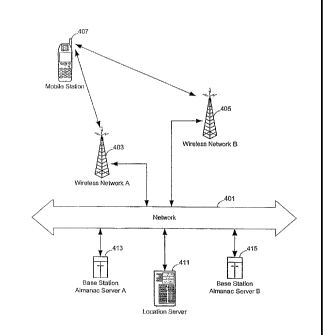
[0041] Figure 4 shows one example of a hybrid positioning system according
to one
embodiment of the present invention. In Figure 4, mobile station 407 utilizes
signals in the air
that are transmitted from -both wireless access point 403 of wireless network
A and wireless
access point 405 of wireless network B for,position determination. In one
embodiment of the
present invention, the mobile station includes a receiver for receiving SPS
signals from SPS
satellites (e.g., GPS satellites, not shown in Figure 4). Timing measurements
(e.g., -
pseudorange, round trip time, times of arrival of signals, time differences of
arrival of signals)
based on the wireless signals from one or both of wireless networks A and B
(and SPS
signals) may be used to determine the position of the mobile station. It is
understood that, in
general, each of wireless networks A and B includes a number of access points
(e.g., cellular
base stations such as wireless access points 403 and 405). Wireless networks A
and B may use
the same type of air interface, operated by different service providers or
they may operate
with the same communication protocols but at different frequencies. However,
wireless
networks A and B may also use different types of air interfaces (e.g., TDMA,
GSM, CDMA,
W-CDMA, UMTS, 1D-SCDMA, 1DEN, BDR, bluetooth, UWB, IEEE 802.11, or other
similar networks), operated by the same service provider or by different
service providers.
[0042] In one embodiment of the present invention, the position
determination is
performed at location server 411 shown in the example depicted in Figure 4.
Mobile station
407 communicates the infaimation extracted from the observed SPS signals
(e.g., SPS
CA 02896425 2015-07-06
' 74769-1261D2
14
pseudorange measurements, a record of an SPS message for comparison to
determine a time
of signal reception) and the information extracted from the observed wireless
signals (e.g., the
identification of an access point, round trip or one-way time measurements
between mobile
station 407 and at least one of the wireless access points, received signal
levels) to the location
server through one of the wireless networks, such as wireless network A (e.g.,
when the
mobile station is a subscriber of wireless network A but not a subscriber of
wireless network
B). Servers 413 and 415 maintain the almanac data for wireless networks A and
B
respectively. This almanac data may simply be, in one exemplary
implementation, a database
listing a latitude and longitude for each wireless access point which is
specified by an
identification information (e.g. MAC address or cell tower identifier, etc.).
Location server
411 uses the information communicated from the mobile station and the data in
the almanac.
servers 413 and 415 to determine the position of the mobile station. The
location server 411
may determine the location of the mobile station in a number of different
ways. It may, for
example, retrieve from servers 413 and 415 the locations Of wireless access
points 403 and
405 and use those locations and, the range measurements, which indicate a
distance between =
the mobile station 407 and the points 403 and 405, and the SPS pseudorange
measurements
and SPS ephemeris information to calculate a position of the mobile station
407. U.S. Patent
No. 5,999,124 provides a discussion of how range measurements from a single
wireless
network and SPS pseudorange measurements may be combined to calculate a
position of a
mobile station. Alternatively, the location server 411 may use only
terrestrial range
measurements (or other types of measurements such as signal strength
measurements) to
multiple wireless access points of multiple wireless networks to calculate the
position if many
(e.g. more than 3) such range measurements can be made; in this case, there is
no need to
obtain SPS pseudoranges or SPS ephemeris information. If SPS pseudoranges to
SPS
satellites are available, these pseudoranges can be combined with SPS
ephemeris information,
obtained either by the mobile station or by a collection of GPS reference
receivers as
described in U.S. Patent No. 6,185,427, to provide additional information in
the position
CA 02896425 2015-07-06
74769-1261D2
calculations
[0043] Network 401 may include local area networks, one or more intranets
and the
Internet for the infounation exchange between the various entities. It is
understood that
servers 411, 413 and 415 may be implemented as a single server program, or
different server
programs in a single data processing system or in separate data processing
systems (e.g.,
maintained and operated by different service providers).
[0044] In one embodiment of the present invention, different service
providers operate
wireless networks A and B, which are used by the mobile station for position
determination. A
typical mobile station is a subscriber only to one of them, and thus the
mobile station is
authorized to use (and to have access to) only one wireless network. However,
it is often still
possible to at least receive signals from the-wireless network which is not
subscribed to and =
thus it is still possible to make range measurements or signal strength
measurements relative
to wireless access points in the wireless network which is not subscribed to.
One specific
example of this situation would involve a user of a tri-mode CDMA cellular
phone which can
receive PCS frequency band signals (such as, for example, from the wireless
network operated
by Sprint, which is a first service provider) and can also receive other CDMA
signals at other
frequencies (such as, for example, from the wireless network operated by
Verizon Wireless,
which is a second service provider). If the user has subscribed only to
Sprint's wireless
network, then the user's phone (a form of a mobile station) is authorized to
operate with
Sprint's wireless network but not Verizon's wireless network The user may use
the phone in
an environment in which only one Sprint wireless access point (e.g. a Sprint
cellular base
station) is capable of radio communication with the user's phone, but in this
environment there
are numerous Verizon wireless access points which are within radio
communication range of
the user's phone. In this context, it is still possible for the phone to
obtain SPS assistance data
(if desired) from a location server through Sprint's wireless network and to
transmit SPS
pseudoranges, obtained at the phone, to the location server. However, it will
not be possible
to obtain more than one range measurement to a wireless access point unless
range
CA 02896425 2015-07-06
' 74769-1261D2
16
measurements to Verizon's wireless access points are obtained. With an
embodiment of the
invention, the phone obtains range measurements to the available Verizon
wireless access
points, thereby providing at least a few range measurements (e.g. distances
between the
phone and two Verizon cellular base stations) which can be used in the
position calculations
that are performed to determine the position of the phone.
[0045] The service providers maintain the almanac information on servers
413 and 415
separately. Although mobile station 407 has communication access to only one
of the wireless
networks, location server 411 may have access to both servers 413 and 415 for
base station
almanac data. After determining the identities of base stations (e.g. the
wireless access points
403 and 405) of both wireless networks A and B, the mobile station 407
transmits the base
station-identifications to location server 411, which uses servers 413 and 415
to retrieve the
corresponding positions of the base stations, which can be used in determining
the position of . -
the mobile station.
[0046] Alternatively, the cooperation between the service providers to
share almanac data "
is not necessary. For example, the operator of location server 411 maintains
both almanac
servers 413 and 415 (e.g., through a survey process to obtain the almanac
data, or through a
data harvesting process using mobile stations, which will be described in
detail with Figures 6
and 7 and 10).
[0047] In one embodiment of the present invention, mobile station 407 uses
both wireless
networks A and B for communicating with the location server (instead of using
only one of
the wireless networks for communication purpose). As known in the art, various
types of
information can be exchanged between the mobile station and the location
server for position
determination. For example, location server 411 can provide the mobile station
407 with
Doppler frequency shift information for in view satellites of the mobile
station (e.g., through
wireless network A); and, the mobile station can provide pseudorange
measurements for SPS
signals, the identification information of the base stations and associated
range measurements
(e.g., round trip time measurements) to the location server for the
calculation of the position
CA 02896425 2015-07-06
' 74769-1261D2
17
of the mobile station (e.g., through wireless network B). In one embodiment of
the present
invention, a mobile station is capable of communicating through more than one
wireless
network to the location server when in the coverage area of these wireless
networks.
However, the trade-off between cost and performance may dictate communication
with the
server using one of the wireless networks, while using the others only for
timing
measurements (or other measurements, such as received signal levels) or for
aiding in .
measurement, such as obtaining time information from wireless transmission
from an access
point for time stamping measurements (e.g., for resolving ambiguity), or
locking to the
accurate carrier frequency of a wireless cellular base station for calibrating
the local oscillator
of the mobile station.
[0048] In- one embodiment of the present invention, the location -of the
mobile station is
determined at the location server using the information communicated from the
mobile station
and then transmitted back to the mobile station. Alternatively, the position
calculation can be
performed at the mobile station using assistance information from the location
server (e.g.,
Doppler frequency shifts for in view satellites, positions and coverage areas
of access points,
differential GPS data, altitude aiding information).
[0049] Figure 5 shows another example of a hybrid positioning system
according to one
embodiment of the present invention. An access point of one wireless network
(e.g., cellular
base station 503) is used for the communication between mobile station 507 and
location
server 511. A method for determining the position of mobile station 507 may
use SPS signals
(e.g., from satellite 521), wireless signals from the access points (e.g.
cellular phone base
station 503) of the wireless network used for data communication, as well as
the wireless
signals from access points- of other wireless networks, such as those from
access point B
(505), which can be a base station of a different wireless cellular phone
network (e.g.,
operated by a different service provider, or using a different air interface),
and from access
point A (509), which can be a wireless LAN access point (e.g., a bluetooth
access point or a
Wi-Fi wireless access point).
CA 02896425 2015-07-06
' 74769-1261D2
IS
[0050] Typically, a wireless LAN access point (or other similar low power
transmitters)
has a small coverage area. When available, the small coverage area of such an
access point
provides a very good estimate of the location of the mobile station. Further,
wireless LAN
access points are typically located near or inside buildings, where the
availability of other
types of signals (e.g., SPS signals or wireless telephone signals) may be low.
Thus, when
such wireless transmissions are used with other types of signals, the
performance of the
positioning system can be greatly improved.
[0051] In one embodiment of the present invention, the wireless signals
from different
wireless networks are used for position determination. For example, the
wireless signals from
the different wireless networks can be used to deteimine the identities of the
corresponding
access points, which are then used to determine the locations and coverage
areas of the
corresponding access points. When precision range information (e.g., round
trip time or signal -
traveling time between an access point and the mobile station) is available,
the range
information and the location of the access point can be used in obtaining a
hybrid positioning
solution. When approximate range information (e.g., received signal level,
which can be
approximately correlated with an estimated range) is available, the location
of the access point
can be used to estimate the position of the mobile station (or determine the
estimated altitude
of the mobile station). Further, the mobile station can use precision carrier
frequency from one
of the wireless networks (e.g., from access point 505 or 509), which may not
be the one used
for the data communication purpose, to calibrate the local oscillator of the
mobile station.
More details about locking to a precision carrier frequency of a wireless
signal to provide a
reference signal at an SPS receiver for signal acquisition can be found in
U.S. Patent No.
5,874,914. Further, the mobile station can use the accurate time information
in the wireless
signals from one of the wireless networks (e.g., from access point 505 or
509), which may not
be the one used for the data communication purpose. More details about using
the accurate
time information (e.g., timing markers, or system time) for time stamping can
be found in
U.S. Patent No. 5,945,944.
CA 02896425 2015-07-06
74769-1261D2
19
[0052]
Since some of the access points of the different wireless networks do not have
well-known almanac data (e.g., position of the wireless access point, coverage
area of the
wireless access point), one embodiment of the present invention derives the
almanac data
from the information collected from mobile stations. Figure 6 illustrates one
method to
determine the position of a wireless access point according to one embodiment
of the present
invention. In Figure 6, a location server does not know the position of access
point antenna
601. To calculate the position of the access point, the location server
correlates the positions
of one or more mobile stations and their corresponding ranges to the access
point, which are
obtained from the mobile stations while performing position determination for
the mobile
stations. For example, a mobile station at position L1 (611) determines range
R1 (613) to
access-point antenna 601. The mobile station obtains--measurements based on
SPS signals (e.g.
measurements of SPS pseudoranges and extraction of SPS ephemeris information
from SPS
signals) and wireless -transmissions (e.g. range measurements). The mobile
station may
calculate its position using the measurements and transmit to the location
server the calculated
position with: i) the range to the access point antenna; and, ii) the identity
of the access point
antenna_ Alternatively, the mobile station may transmit: i) the measurements;
the range to
the access point antenna; and, the
identity of the access point antenna to the location
server, which calculates the position of the mobile station using the
measurements and which
stores the range measurements (e.g. R1, R2 and R3 and the corresponding
positions (e.g. Li,
L2, and L3). When a number of data points are available, each of which data
points correlates
the position of a mobile station and the range from the mobile station to the
access point
antenna, the location server determines the position of the access point
antenna. It can be seen
from Figure 6 that as few as three range measurements (R1, R2, and R3) and
their
corresponding positions (1,1, L2, and L3) are sufficient to specify a
particular location of the
identified access point (which is shown at the intersection of three circles
specified by the
three ranges). Various methods that have been used in the art for calculating
the position of a
mobile station based on range infoimation can be used to calculate the
position of the access
CA 02896425 2015-07-06
74769-1261D2
point. Note that the data points may be from a single mobile station or from a
number of
mobile stations.
[0053] Further, the accumulated data points of the locations of mobile
stations show the
coverage area of the access point (e.g., in a scatter plot of the mobile
locations). When the
position of the access point is not known, the collected data points can be
used to estimate the
position and the coverage of the access point. When an initial estimation of
the position of the
access point is available, the collected data points can be used to improve
the estimation. The
collection and enhancement process can be a continuous process during the
service of the
= location server. Note that the collection and enhancement operations can
also be performed on
a different server other than the location server. For example, in one
embodiment of the
present invention, the collection and enhancement operations are-performed in
almanac server
513, which communicates with location server 511 in performing hybrid position
determination for mobile stations.
[0054] However, precision information of range to some access points
may not be
available to mobile stations of a location server. Figure 7 illustrates
another method to
determine the position informatiOn of a wireless access point according to one
embodiment of
the present invention. A larger number of data points (e.g., 711, 713, 715,
721, 723, 725) of
the locations of mobile stations that can receive signals from the access
point (e.g., 703)
define a coverage area (e.g., 705) of the access point (e.g., through a
scatter plot of the
locations, the smallest circle enclosing the data points). From the coverage
area, the location
server can calculate an estimated position of the access point (e.g., the
geometric center of the
coverage area). Further, range information (e.g., an indicator of the received
signal level, a
round trip time) may be used to define a weight for determining the weighted
average of the
coverage area (e.g., the closer to the access point, the larger the weight),
from which the
estimated position of the access point is determined_ Further, in one
embodiment, the location
server determines the probability of a mobile station being at a particular
location from the
statistics of the mobile stations, given certain range information is
specified. Other
CA 02896425 2015-07-06
' 74769-1261D2
21
information, such as the signal level of wireless transmission from other
transmitters, can then
be further used to narrow the possible locations of the mobile station.
[00551 For example, a wireless LAN access point is located inside building
701. While
SPS signals (e.g., signals from SPS satellites 741 ¨ 745) and wireless
cellular phone signals
(e.g., signals from cellular base station 751) may be weak inside building
701, the position of
a mobile station can be easily determined (e.g., without using the signals
from access point
703) at certain locations around the building (e.g., locations 711 ¨ 725,
which may be just
outside the building or at certain locations inside the building, such as
spots close to
windows). In one embodiment of the present invention, the identification of
the access point is
determined and sent to the server with the location of the mobile station (or
information
specifying the location of the mobile, such as pseudoranges to in view
satellites) for the
determination of the coverage area (and/or the position) of the access point
703. The location
information of the access point (e.g., coverage area, position) can be
maintained at the server
(or a different server). When a mobile station is inside a building (or at a
position near the
building), where the blockage of some of the SPS signals and. cellular phone
signals occurs,
the location information about the access point can be used to aid in
determining the position
of the mobile station.
[00561 It is understood that some access points may be moved from one
location to
another. In one embodiment of the present invention, the server tracks the
collected position
information about one or more mobile stations that receive the transmission
from one access
point in order to determine if the access point is moved. For example, the
server may
compare the old coverage area with the recent coverage area (e.g., through
comparing the
center and the radius of the coverage area) to determine if the access point
is moved.
Alternatively, the server may periodically discard old information in view of
newly collected
information. Further, the server may weight the collected infoiniation so that
the freshly
collected data carries more weight in determining the coverage area and/or the
location of the
access point and the influence from the data collected previously may
eventually diminish
CA 02896425 2015-07-06
74769-1261D2
22
over time. Further, the server may determine if an access point moves
frequently; and, if the
access point moves frequently, the access point may be disqualified as a
reference point for
the position determination. Further, in one embodiment, when an access point
has not been
observed for a certain period of time, the access point is removed from the
database; similarly,
when a new access point is observed, it is added to the database. Thus, the
server may update
= the information about the access point in an ongoing basis.
[0057] In at least one embodiment of the present invention, a mobile
station can determine
its position without a communication link. The mobile station has memory for
storing at least
some of the information about the locations of the mobile station and the
corresponding
received signal levels or range measurements of a number of wireless access
points (e.g., for
cellular phone access, or for wireless- LAN access). The mobile- station
transmits the data to a .
server when a communication link (e.g., a- wire connection through a
communication port of
the mobile. station or a wireless connection through a transceiver of the
mobile station) is
available. Alternatively, the mobile station may directly use the stored
information to derive
the position information about the access point in determining its 6wn
position when needed.
[0058] Figure 8 shows a general method of hybrid position
determination using a
plurality of wireless networks according to one embodiment of the present
invention. In
operation 801, a mobile station receives wireless signals transmitted from a
plurality of
wireless access points of different wireless networks (e.g., wireless networks
of different air
interfaces, wireless networks of different service providers, wireless
networks operating at
different frequencies, wireless networks using different communication
protocols, etc.). In
operation 803, the mobile station utilizes the wireless signals from each of
the access points of
the different wireless networks in determining the position of the mobile
station (e.g., to
determine the identity of the access point, to lock a local oscillator of the
mobile station to a
precision carrier frequency of a wireless signal, to obtain a timing indicator
from a wireless
signal, to determine signal transmission delay between the mobile station and
one of the
access points, to communicate with a server). In general, the mobile station
may use the
CA 02896425 2015-07-06
74769-1261D2
23
wireless signals from access points of different wireless networks to perfoini
different
operations, although the mobile station may use the wireless signals from
access points of
some different wireless networks to perform a number of similar operations. In
operation 805,
the mobile station communicates with a server to deteimine the position of the
mobile station
using at least one of the different wireless networks. Typically, the mobile
station
communicates with the server using only one of the different wireless
networks; however, the
mobile station may communicate with the server using more than one wireless
network (e.g.,
to transmit the time of reception at an access point for a signal transmitted
from the mobile
station, to transmit a round trip time, or to transmit other information to or
from a location
server).
[0059] Figure 9 shows a method- of -hybrid position determination using-
two wireless
networks for communication with a server according to one embodiment of the
present -
invention. Operation 821 receives, at a mobile station, SPS = signals
transmitted from one or
more SPS satellites and wireless signals transmitted from a plurality of
wireless access points
of more than one wireless network. The mobile station may use the received
wireless signals
from one or more wireless networks to aid in SPS signal acquisitions (e.g., to
extract Doppler
frequency shifts for in view satellites of the mobile station, to calibrate
the local oscillator of
the mobile station, to obtain a timing indicator to time stamp a measurement).
The mobile
station uses the SPS signals to determine pseudoranges to in view satellites,
and the mobile
station uses wireless signals from the wireless access points to identify the
access points and
to perform range measurements to the wireless access points for position
determination. These
received signals are typically broadcast from the transmitters of the
satellites and wireless
access points and available to any mobile station that chooses to use them.
Operation 823
communicates first information (e.g., a record of an SPS message) between the
mobile station
and a server using an access point' of a first wireless network (e.g., a
wireless local area
network). Operation 825 communicates second information (e.g., Doppler
frequency shifts,
ephemeris data for in view SPS satellites) between the mobile station and a
server using an
CA 02896425 2015-07-06
74769-1261D2
24
access point of a second wireless network (e.g., a wireless cellular phone
network). Operation
827 determines the position of the mobile station from the communication of
the first
information and the second information. Typically, the availability, coverage,
expense, data
speed, and ease of use are considered when choosing which communications path
to use.
Further, the mobile station may use different communication paths at different
locations. For =
example, when the mobile station is within the coverage area of a wireless LAN
(e.g., a home
network), the mobile station may use the wireless LAN (e.g., through intemet)
to
communicate with the server for information that does not need to pass through
the base
station of a wireless cellular phone system (e.g., Doppler frequency shifts);
and, use the base
station of the wireless cellular phone system to transmit the information that
is related to the
base station (e.g., round trip time measurement to the- base stations of the
wireless cellular -
phone system). In a further example, the mobile station may choose to use
either the- wireless
cellular phone system or the wireless LAN for communication according to the
communication cost and availability. In one embod.ment of the present
invention, the mobile
station automatically determines the communication path according to a set of
rules (e.g.,
availability, cost, priority, and others) which may be specified by a user of
the mobile station -
or may be set as a default setting by one of the wireless networks.
[0060] Figure 10 shows a method to generate location information about a
wireless
access point according to one embodiment of the present invention. Operation
841 detects, at
a mobile station, wireless signals transmitted from a wireless access point
(e.g., a wireless
access point that is in compliance with the IEF.F 802.11 standard for wireless
local area
network, or other types of ground-based wireless transmitters that transmit
signals with their
identification information). Note that, in the present application, wireless
access points do not
include satellite-based transmitters. Operation 843 determines identification
information,
which may be a unique identifier, of the wireless access point (e.g., the MAC
address of the
wireless access point or an identifier of a cellular base station) from the
wireless signals.
Operation 845 determines the position of the mobile station (e.g., at the
mobile station or at a
CA 02896425 2015-07-06
74769-1261D2
location server). For example, the mobile station may calculate the position
based on the
pseudorange measurements and other range information; or, the mobile station
may transmit
the pseudorange measurements and the range information to a location server,
which
calculates the position of the mobile station (and, the location server may
send back the
calculated position to the mobile station). Operation 847 correlates the
position of the mobile
station with the identification information of the wireless access point. This
correlation may
be transmitted to a location server so that future positioning operations of
mobile stations may
use the position and identification information to determine a position of the
identified
wireless access point. Operation 849 generates location information about the
wireless access
point (e.g., access point almanac, statistics of coverage area of the wireless
access point).
Typically, the correlation data is sent to a- server (e.g., a location server,
or an access point
almanac server) which generates location information about the access point
based on a
number of positions of one or more mobile stations that report the reception
of signals
transmitted from the access point. The location information about the wireless
access point
can be derived from a weighted average method as described above (or other
methods, such
as, using the range information as shown in Figure 6). However, a mobile
station may also
track the correlation and derive the location information about the wireless
access point (e.g.,
from data points collected at different time instances). The location
information about the
wireless access point can then be used for position determination.
[0061]
Figure 11 shows a hybrid position determination method using one wireless
network for communication and another wireless network for the measurement of
positioning
parameters according to one embodiment of the present invention. Operation 861
detects, at a
mobile station, wireless signals transmitted from a wireless access point
(e.g., a wireless
access point that is in compliance with the IEEE 802.11 standard for wireless
local area
network, or a cellular communication base station) of a first wireless network
(e.g., a wireless
local area network, or a cellular phone communication system). Operation 863
determines the
identification infoimation of the wireless access point (e.g., the MAC
address, or the base
CA 02896425 2015-07-06
74769-1261D2
26
station ID) from the wireless signals. Operation 865 retrieves location
infoi_uation about the
wireless access point (e.g., access point almanac) using the identification
infoimation. For
example, the mobile station may transmit identification information of the
wireless access
point to location server, which retrieves the location information about the
wireless access
point using the identification information (e.g., from a database, or from
another server, such
as an access point almanac server). In another example, the mobile station
maintains the
location information about the wireless access point in memory; thus, the
location information
is simply retrieved from the memory of the mobile station. Operation 867
determines the
position of the mobile station using the location information and using a
communication linIc
between the mobile station and a wireless access point of a second wireless
network (e.g., a
cellular phone network). For example, satellite assistance data (e:g.,-
Doppler frequency
shifts) for the acquisition of SPS signals or timing measurements (e.g.,
pseudoranges or time =
of arrivals of SPS signals) are communicated through the second wireless
network for the
determination of the position of the mobile station.
[0062]
Figure 12 shows another exemplary method of the inventions. In this
method, a
mobile station receives, in operation 901, first signals transmitted from a
first wireless access
point of a first wireless network. The first wireless network may support two-
way
communication between the various nodes within the first wireless network as
well as nodes
outside of this network. In operation 903, at least one range measurement is
determined using
the first signals. If additional signals from other wireless access points of
the first wireless
= network are also available, then additional range measurements to these
other wireless access
points (and their identification information) are obtained. In an alternative
implementation of
operation 903, another measurement (e.g. a signal strength measurement of the
first signals)
may be taken by the mobile station without attempting to make a range
measurement using
the first signals. In one exemplary implementation, a time of travel of the
first signals from
the first wireless access point to the mobile station is measured and an
identification of this
first wireless access point is received from the first wireless access point.
In operation 905,
CA 02896425 2015-07-06
74769-1261D2
27
second signals are communicated between the mobile station and a second
wireless access
point of a second wireless network, which is different than the first wireless
network. The
mobile station may, in this operation, receive the second signals (which may
include SPS
assistance data, etc.) from the second wireless access point. In operation
907, the mobile
station and the server communicate to determine the position of the mobile
station, and this
communication may be through the second wireless access point. For example,
the mobile
station may, in operation 907, transmit the range measurements and
identification
information, performed in operation 903, and SPS pseudoranges, obtained by the
mobile
station, to the server through the second wireless access point_ The
identification information
is used to obtain the location of the wireless access points to which range
measurements (or
- other measurements) were obtained; and the server may then determine -the
position of the
mobile station using at least some of the available measurements (e.g. the SPS
pseudoranges
to SPS satellites and the range measurements, or other measurements, to
various terrestrial
wireless access points). Alternatively, the mobile,station may determine its
position (rather
than the server doing so) using the range measurements and SPS pseudoranges
and using
information provided by the server (such as the location of the identified
wireless access
points in one or both of the wireless networks).
[0063] The first wireless network in Figure 12 may be a wireless local
area network and,
in this case, the first wireless access point may be a wireless router
operating according to a
Wi-Fi standard. Alternatively, the first wireless network may be a wireless
cellular telephone
network operated by a first service provider, and the second wireless network
may be another
(different) wireless cellular telephone network Operated by a second service
provider, and the
mobile station, which may be a cellular telephone with an integrated GPS
receiver, is
authorized to operate with only the second wireless network and not the first
wireless
network. Various other alternatives, discussed herein, may also apply to this
example of
Figure 12.
[0064] Figure 13 is another example of a method of the inventions. In
this example, the
CA 02896425 2015-07-06
74769-1261D2
28
mobile station, in operation 931, obtains an identification infoimation of a
first wireless access
point of a first wireless network that is accessible (e.g. within radio
communication) to the
mobile station. This identification may be a MAC address (e.g. for an Ethernet
local area
network) or a cellular telephone base station (e.g. "cell tower") identifier.
In operation 933,
the mobile station transmits, through a second wireless access point of a
second wireless
network, the identification information to a server (e.g. a location server)
during a position
determination operation. In this example, the second wireless network is
different than the
first wireless network (e.g. different air interfaces, different service
providers, etc.). Then, in
operation 935, the server uses the identification information of the first
wireless access point
to determine the location of the first wireless= access point (which may have
been
harvested/collected through methods described herein, such as in Figure 14).
The server may
also, in operation 935, use other data (e.g. SPS pseudoranges determined at a
GPS receiver
which is integrated into the mobile station and then transmitted to the
server) to determine the
position of the mobile station. The server may, for example, combine the SPS
pseudoranges
with the measurements on signals from the wireless access points to determine
the position of
the mobile station_ Alternatively, the SPS pseudoranges may be combined with
the known
locations of the wireless access points (particularly in the case of wireless
LANs which have
shorter signal ranges). In another alternative to operation 935, the server
may provide
assistance data (e.g. the location of the first wireless access point and
possibly other data such
as Doppler data for SPS satellites in view of the mobile station, etc.) to the
mobile station but
the server does not compute the position of the mobile station; rather, the
mobile station
performs the position solution using at least some of the available
measurements (e.g. SPS
pseudoranges, range measurements or other measurements relative to the
wireless access
points of one or all available wireless networks) and the available assistance
data from the
server.
[0065]
Figure 14 shows another exemplary method of the inventions. This method
ultimately dere/mines positions of wireless access points so that future
position determination
CA 02896425 2015-07-06
74769-1261D2
29
operations for mobile stations can be performed using multiple wireless
networks as described
herein. In operation 971, data is collected. This data specifies a plurality
of locations of
mobile stations at which wireless signals, transmitted from at least a first
wireless access point
of a first wireless network, are received during determinations of the
plurality of locations.
The mobile stations may, in operation 973, receive signals from the first
wireless access
points and also communicate signals between the mobile stations and at least
one second
wireless access point of a second wireless network (which is different than
the first wireless
network). This communication with the second wireless network may be for the
purpose of
providing information used in collecting the data 'which is used to determine
the locations of
wireless access points of the first wireless network_ In operation 975, the
location of at least
the first wireless access point is determined (e.g. in the manner shown in
Figure 6) from the
coverage area defined by the plurality of locations.
[0066]
Figure 2 shows an example of a data processing system which may be used as a
server in various embodiments of the present invention. For example, as
described in U.S.
Patent No. 5,841,396, the server (201) may provide assistance data such as
Doppler or other
satellite assistance data to the GPS receiver in a mobile station. In
addition, or alternatively,
the same server or a different server may perform the final position
calculation rather than the
mobile station (after receiving pseudoranges or other data from which
pseudoranges can be
determined from the mobile station) and then may forward this position
determination result
to the base station or to some other system. The data processing system as a
server (e.g., a
location server, an almanac server) typically includes communication devices
212, such as
modems or network interface. The location server may be coupled to a number of
different
networks through communication devices 212 (e.g., modems or other network
interfaces).
Such networks include one or more intranets, the network, the cellular
switching center or
multiple cellular switching centers 225, the land based phone system switches
223, cellular
base stations (not shown in Figure 2), GPS receivers 227, or other processors
or location
servers 221.
CA 02896425 2015-07-06
74769-1261D2
[00671
Multiple cellular base stations are typically arranged to cover a geographical
area
with radio coverage, and these different base stations are coupled to at least
one mobile
switching center, as is well known in the prior art (e.g., see Figure 1).
Thus, multiple base
stations would be geographically distributed but coupled together by a mobile
switching
center. The network 220 may be connected to a network of reference GPS
receivers which
provide differential GPS information and may also provide GPS ephemeris data
for use in
calculating the position of mobile systems. The network is coupled through the
modem or
other communication interface to the processor 203. The network 220 may be
connected to
other computers or network components. Also network 220 may be connected to
computer
systems operated by emergency operators, such as the Public Safety Answering
Points which
respond to 911 telephone calls_ Various examples of methods for using a
location server have
been described in numerous U.S. Patents, including: U.S. Patents 5,841,396,
5,874,914, =
5,812,087 and 6,215,442.
[0068]
The server 201, which ;is a form of a data processing system, includes a bus
202
which is coupled to a microprocessor 203 and a ROM 207 and volatile RAM 205
and a non-
volatile memory 206. The processor 203 is coupled to cache memory 204 as shown
in the
example of Figure 2. The bus 202 interconnects these various components
together. While
Figure 2 shows that the non-volatile memory is a local device coupled directly
to the rest of
the components in the data processing system, it will be appreciated that the
present invention
may utilize a non-volatile memory which is remote from the system, such as a
network
storage device which is coupled to the data processing system through a
network interface
such as a modem or Ethernet interface. The bus 202 may include one or more
buses connected
to each other through various bridges, controllers and/or adapters as is well
known in the art.
In many situations the location server may perform its operations
automatically without
human assistance. In some designs where human interaction is required, the I/0
controller 209
may communicate with displays, keyboards, and other I/O devices.
[0069]
Note that while Figure 2 illustrates various components of a data processing
CA 02896425 2015-07-06
74769-1261D2
31
system, it is not intended to represent any particular architecture or manner
of interconnecting
the components as such details are not germane to the present invention. It
will also be
appreciated that network computers and other data processing systems which
have fewer
components or perhaps more components may also be used with the present
invention and
may act as a location server or a PDE (position determination entity).
[0070] In some embodiments," the methods of the present invention may be
performed on
computer systems which are simultaneously used for other functions, such as
cellular
. switching, messaging services, etc. In these cases, some or all of the
hardware of Figure 2
would be shared for several functions.
[0071] It will be apparent from this description that aspects of the
present invention may
be embodied, at least in part, in software. That is, the techniques may be
carried out in a
computer system or other data processing system in response to its processor
executing
sequences of instructions contained in memory, such as ROM 207, volatile RAM
205, non-
volatile memory 206, cache 204 or a remote storage device. In various
embodiments,
hardwired circuitry may be used in combination with software instructions to
implement the
present invention. Thus, the techniques are not limited to any specific
combination of
hardware circuitry and software nor to any particular source for the
instructions executed by
the data processing system. In addition, throughout this description, various
functions and
operations are described as being performed by or caused by software code to
simplify
description. However, those skilled in the art will recognize what is meant by
such
expressions is that the functions result from execution of the code by a
processor, such as the
processor 203.
[0072] A machine readable medium can be used to store software and data
which when
executed by a data processing system causes the system to perform various
methods of the
present invention. This executable software and data may be stored in various
places
including for example ROM 207, volatile RAM 205, non-volatile memory 206
and/or cache
204 as shown in Figure 2. Portions of this software and/or data may be stored
in any one of
CA 02896425 2015-07-06
74769-1261D2
32
these storage devices.
[0073] Thus, a machine readable medium includes any mechanism that provides
(i.e.,
stores and/or transmits) infoimation in a form accessible by a machine (e.g.,
a computer,
network device, personal digital assistant, manufacturing tool, any device
with a set of one or
more processors, etc.). For example, a machine readable medium includes
recordable/non-
recordable media (e.g., read only memory (ROM); random access memory (RAM);
magnetic
disk storage media; optical storage media; flash memory devices; etc.), as
well as electrical,
optical, acoustical or other forms of propagated signals (e.g., carrier waves,
infrared signals,
digital signals, etc.); etc.
[0074] Figure 3 shows a block diagram representation of a mobile station
according to
one embodiment of the present invention_ The mobile station includes a=
portable receiver,
which combines va communication transceiver with GPS receiver for use in one
embodiment
of the present invention. The combined mobile unit 310 includes circuitry for
performing the .
functions required for processing GPS signals as well as the functions
required for processing
communication signals received through a communication link. The communication
link,
such as communication link 350 or 360, is typically a radio fiequency
communication link to
another component, such as base station 352 having communication antenna 351
or wireless
LAN access point 362 with antenna 361. Although Figure 3 illustrates an
embodiment that
communication antenna 311 is used for receiving signals from different types
of wireless
access points (e.g., from access point 362 for wireless LAN and from based
station 352 for
cellular phone service), the combined receiver may use separate and distinct
antennas for
receiving signals of different air interfaces. Further, the combined receiver
may use separate
and distinct components for at least a partial processing of the received
wireless signals and
may or may not share some components in the processing of the wireless signals
of different
air interfaces. For example, the combined receiver may have separate circuits
for the RF
signal processing and share same data processor resources. From this
description, various
combinations and variations of the combined receiver will be apparent to one
skilled in the
CA 02896425 2015-07-06
74769-1261D2
33
art.
[0075]
Portable receiver 310 is an example of a combined GPS receiver and a
communication receiver and transmitter. The communication receiver and
transmitter may be
implemented as multiple receivers and transmitters for the different wireless
networks. For
example, the communication transceiver 305 may include a transceiver portion
for receiving
and/or transmitting cellular telephone signals and another transceiver portion
for receiving
and/or transmitting Wi-Fi signals. Receiver 310 contains a GPS receiver stage
including
acquisition and tracking circuit 321 and communication transceiver section
305. Acquisition
and tracking circuit 321 is coupled to GPS antenna 301, and communication
transceiver 305 is
coupled to communication antenna 311. GPS signals (e.g., signal 370
transmitted from
- satellite 303) are received through GPS antenna 301 and input to acquisition
and tracking
circuit 321 which acquires the PN (Pseudorandom Noise) codes for the various
received =
satellites. The data produced by circuit 321 (e.g., correlation indicators)
are processed by
processor 333 for transmittal (e.g. of SPS pseudoranges) by transceiver 305.
Communication
transceiver 305 contains a transmit/receive switch 331 which routes
communication signals
(typically RF) to and from communication antenna 311 and transceiver 305. In
some systems,
a band splitting filter, or "duplexer," is used instead of the UR switch.
Received
communication signals are input to communication receiver 332 and passed to
processor 333
for processing. Communication signals to be transmitted from processor 333 are
propagated to
modulator 334 and frequency converter 335. Power amplifier 336 increases the
gain of the
signal to an appropriate level for transmission to base station 352 (or to
wireless LAN access
point 362).
[0076] In
one embodiment of the present invention, communication transceiver section
305 is capable of being used with a number of different air interfaces (e.g.,
IEEE 802.11,
bluetooth, UWB, 1D-SCDMA, IDEN, UDR, IDMA., GSM, CDMA, W-CDM_A, umrs, or
other similar networks) for communication (e.g., through communication links
350 and 360).
In one embodiment of the present invention, communication transceiver section
305 is
CA 02896425 2015-07-06
74769-1261D2
34
capable of being used with one air interface for communication and capable of
being used to
receive signals with other air interfaces. In one embodiment of the present
invention,
communication transceiver section 305 is capable of being used with one air
interface for
communication while also being capable of being used with signals in another
air interface to
extract timing indicators (e.g., timing frames or system time) or to calibrate
the local oscillator
(not shown in Figure 3) of the mobile station. More details about the mobile
station for
extracting timing indicators or calibrating the local oscillator can be found
in U.S. Patents
5,874,914 and 5,945,944.
[0077] In one embodiment of the combined GPS/communication system of
receiver 310,
data generated by acquisition and tracking circuit 321 is transmitted to a
server over
communication link 350 to base station 352 or over communication link 360 to
wireless LAN
access point 362. The server then determines the location of receiver 310
based on the data.
from the remote receiver, the time at which the data were measured, and
ephemeris data,
received from its own GPS receiver or other sources of such data. The location
data can then
be transmitted back to receiver 310 or to other remote locations_ More details
about portable
receivers utilizing a communication link can be found in U.S. Patent No.
5,874,914.
[0078] In one embodiment of the present invention, the combined GPS
receiver includes
(or is coupled to) a data processing system (e.g., a personal data assistant,
or a portable
computer). The data processing system includes a bus which is coupled to a
microprocessor
and a memory (e.g., ROM, volatile RAM, non-volatile memory). The bus
interconnects
various components together and also interconnects these components to a
display controller
and display device and to peripheral devices such as input/output (I/O)
devices, which are
well known in the art. The bus may include one or more buses connected to each
other
through various bridges, controllers and/or adapters as are well known in the
art. In one
embodiment, the data processing system includes communication ports (e.g., a
USB
(Universal Serial Bus) port, a port for I1-EE-l394 bus connection). In one
embodiment of the
present invention, the mobile station stores the locations and identifications
(e.g., MAC
CA 02896425 2015-07-06
74769-1261D2
address) of wireless access points (e.g., according to the types of the
wireless access points)
for extracting and enhancing the location information about the wireless
access points using
the memory and software program instructions stored in the memory. In one
embodiment, the
mobile station only stores the locations of the mobile station and
identifications of the
wireless access points for transmission to a server (e.g., through a
communication port, or a
wireless communication link) when a communication connection is established.
[0079] Although the methods and apparatus of the present invention have
been described
with reference to GPS satellites, it will be appreciated that the descriptions
are equally
applicable to positioning systems which utilize pseudolites or a combination
of satellites and
pseudolites. Pseudolites are ground-based transmitters which broadcast a PN
code (similar to
a- CPS signal), typically modulated on an L-band carrier signal, generally
synchronized with
GPS time. Each transmitter may be assigned a unique PN code so as to permit
identification
by a remote receiver. Pseudolites are useful in situations where GPS signals
from an orbiting
satellite might be unavailable, such as tunnels, mines, buildings or other
enclosed areas. The
term "satellite", as used herein, is intended to include pseudolites or
equivalents of
pseudolites, and the term GPS signals, as used herein, is intended to include
GPS-like signals
from pseudolites or equivalents of pseudolites.
[0080] In the preceding discussion the invention has been described with
reference to
application upon the United States Global Positioning Satellite (GPS) system.
It should be
evident, however, that these methods are equally applicable to similar
satellite positioning
systems, and in particular, the Russian GLONASS system and the proposed
European Galileo
System. The GLONASS system primarily differs from GPS system in that the
emissions from
different satellites are differentiated from one another by utilizing slightly
different carrier
frequencies, rather than utilizing different pseudorandom codes. In this
situation substantially
all the circuitry and algorithms described previously are applicable. The term
"GPS" used
herein includes such alternative satellite positioning systems, including the
Russian
GLONASS system, and the European Galileo System.
CA 02896425 2015-07-06
74769-1261D2
36
[0081] Although the operations in the above examples are
illustrated in specific
sequences, from this description, it will be appreciated that various
different operation
sequences and variations can be used without having to be limited to the above
illustrated
examples.
[0082] The above examples are illustrated without presenting some
of the details known
in the art; as pointed out in the above discussion;these details can be found
in publications,
such as U.S. Patents 5,812,087, 5,841,396, 5,874,914, 5,945,944, 5,999,124,
6,061,018,
= 6,208,290, and 6,215,442.
[0083] In the foregoing specification, the invention has been
described with reference to ,
specific exemplary embodiments thereof. It will be evident that various
modifications may be
made thereto without departing from the broader scope of the invention aS set
forth
in the following claims. The specification and drawings are, accordingly, to
be regarded in an
= illustrative sense rather than a restrictive sense.
, .
=