Note: Descriptions are shown in the official language in which they were submitted.
CA 02905228 2016-04-13
SYSTEMS AND METHODS FOR
ADJUSTING EXISTING WELL PLANS
FIELD OF THE INVENTION
[0001] The present invention generally relates to systems and methods for
adjusting
existing well plans.
[0002] More particularly, the present invention relates to adjusting existing
well plans
by matching the existing well plans that can be replanned with new well plans
that are
generated around on the existing well plans that cannot be replanned such as,
for example,
drilled, planned and/or permitted wells.
BACKGROUND OF THE INVENTION
[0003] In today's oil and gas industry, wells that are deviated are most
common and
more often than not, deviated to horizontal ¨ meaning an inclination of about
75-90 degrees.
There are a number of established plays that utilize mass planning and
targeting for
horizontal drilling like the SAGD (Steam Assisted Gravity Drainage) in Canada
and the
Marcellus, Hornriver and Barnett shale gas plays.
[0004] In order to optimize the number of wells to completely exploit one of
these
plays, companies are planning hundreds, and in some case thousands, of wells
for an entire
asset in a defined area, which is often very time-consuming and requires
numerous resources.
There are therefore, numerous types of resource plays that require horizontal
laterals to be
positioned and spaced to fill a field with a regular or irregular shaped lease
or unit boundary.
The objective is to maximize the coverage within this area based on
1
CA 02905228 2015-09-17
WO 2014/175858 PCT/US2013/037627
lateral constraints, such as min/max lateral lengths, lateral spacing and
heeUtoe, heel/heel or
toe/toe spacing. Companies often rely on conventional technology to help
accomplish this
objective and as a result are often limited with respect to the number of
scenarios that can be
analyzed. Once the drilling operation has commenced and information from wells
being drilled
is coming in from the field, engineers rely on conventional technology to
update the field plan
based on actual data and are limited in their options for re-distributing the
remaining horizontal
laterals. This process can easily take months to complete depending on the
size of the field and
the number of wells that are being planned.
[0005] One of the bigger issues with horizontal lateral field development
involves
modifying the field plan after some of the wells have been permitted and
drilled. An operator
might, for instance, have initially planned the field using 800 foot spacing
between parallel
horizontal wells and discovered that 750 foot spacing is more appropriate for
this field due to the
results of drilling and fracking the first few wells. Or, an operator might
determine that the
initially planned 330 degree well orientation is not as effective as a 320
degree orientation. At
this point, several wells are drilled, a few more are currently being drilled
and others may be
permitted, but not drilled. Hundreds to thousands of wells may also be planned
and identified
within the operator's internal systems with unique identifiers. Those well
plans need to be moved
into new locations, without losing their reference to the operator's internal
identification system.
In addition to lateral movements, there may be a need to alter the vertical
positioning. This might
be required to adjust to a revised earth model or to target a different
position within the reservoir,
to give the wells more of an upward tilt, or to more closely follow the
contours of the reservoir.
Past attempts have involved convoluted workflows that require the operators to
delete all non-
2
CA 02905228 2015-09-17
WO 2014/175858 PCT/US2013/037627
permitted well plans, perform the planning, then try to determine which new
plans might be
close enough to the old ones to transfer the corporate identification over.
BRIEF DESCRIPTION OF THE DRAWINGS
[0006] The present invention is described below with references to the
accompanying
drawings in which like elements are referenced with like reference numerals,
and in which:
[0007] FIG. 1 is a flow diagram illustrating one embodiment of a method for
implementing the present invention.
[0008] FIG. 2 is a flow diagram illustrating one embodiment of a method for
performing
step 103 in FIG. I.
[0009] FIG. 3 is a flow diagram illustrating one embodiment of a method for
performing
step 105 in FIG. 1.
[0010] FIG. 4 is a flow diagram illustrating one embodiment of a method for
performing
step 316 in FIG. 3.
[0011] FIG. 5 is a plan view illustrating step 101 in FIG. 1.
[0012] FIG. 6 is a plan view illustrating step 102 in FIG. 1.
[0013] FIG. 7 is a plan view illustrating step 114 in FIG. 1.
[0014] FIG. 8 is a block diagram illustrating one embodiment of a computer
system for
implementing the present invention.
DETAILED DESCRIPTION OF THE PREFERRED EMBODIMENTS
[0015] The subject matter of the present invention is described with
specificity, however,
the description itself is not intended to limit the scope of the invention.
The subject matter thus,
might also be embodied in other ways, to include different steps or
combinations of steps similar
to the ones described herein, in conjunction with other technologies.
Moreover, although the
3
CA 02905228 2015-09-17
WO 2014/175858 PCT/US2013/037627
term "step" may be used herein to describe different elements of methods
employed, the term
should not be interpreted as implying any particular order among or between
various steps herein
disclosed unless otherwise expressly limited by the description to a
particular order. While the
following description refers to the oil and gas industry, the systems and
methods of the present
invention are not limited thereto and may also be applied in other industries
to achieve similar
results.
[0016] The present invention overcomes one or more deficiencies in the prior
art by
adjusting existing well plans by matching the existing well plans that can be
replanned with new
well plans that are generated around the existing well plans that cannot be
replanned such as, for
example, drilled, planned and/or permitted wells.
[0017] In one embodiment, the present invention includes a method for
adjusting
existing well plans, which comprises: i) separating existing well plans that
cannot be replanned
into a ListA and existing well plans that can be replanned into a ListB; ii)
generating new well
plans around the ListA well plans; iii) separating the new well plans into a
ListC; iv)
determining which ListB well plans match respective ListC new well plans; v)
adjusting each
ListB well plan that matches a respective ListC new well plan to a new
position; and vi)
removing each ListC new well plan that matches a respective ListB well plan
and each ListB
well plan that does not match a respective ListC new well plan.
[0018] In another embodiment, the present invention includes a non-transitory
program
carrier device tangibly carrying computer executable instructions for
adjusting existing well
plans, the instructions being executable to implement: i) separating existing
well plans that
cannot be replanned into a ListA and existing well plans that can be replanned
into a ListB; ii)
generating new well plans around the ListA well plans; iii) separating the new
well plans into a
4
CA 02905228 2015-09-17
WO 2014/175858 PCT/US2013/037627
ListC; iv) determining which ListB well plans match respective ListC new well
plans; v)
adjusting each ListB well plan that matches a respective ListC new well plan
to a new position;
and vi) removing each ListC new well plan that matches a respective ListB well
plan and each
ListB well plan that does not match a respective ListC new well plan.
[0019] In yet another embodiment, the present invention includes a method for
adjusting
existing well plans, which comprises: i) separating existing well plans that
cannot be replanned
into a ListA and existing well plans that can be replanned into a ListB; ii)
generating new well
plans around the ListA well plans; iii) separating the new well plans into a
ListC; iv) determining
which ListB well plans match respective ListC new well plans by: a)
determining initial
matching criteria; b) identifying a list of possible matches for ListB well
plans and ListC new
well plans based on the initial matching criteria; and c) reducing the list of
possible matches for
ListB well plans and the list of possible matches for ListC new well plans to
one best possible
match for each respective well plan and its match; v) adjusting each ListB
well plan that matches
a respective ListC new well plan to a new position; and vi) removing each
ListC new well plan
that matches a respective ListB well plan and each ListB well plan that does
not match a
respective ListC new well plan.
Method Description
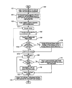
[0020] Referring now to FIG. 1, a flow diagram of one embodiment of a method
100 for
implementing the present invention is illustrated.
[0021] In step 101, ListA and ListB are set equal to well plans that cannot be
replanned
and well plans that can be replanned, respectively. ListA and ListB are plans
within an existing
field development project. In FIG. 5, for example, the plan view 500
illustrates an
unconventional field with ListA existing well plans as solid lines and ListB
existing well plans as
CA 02905228 2015-09-17
WO 2014/175858 PCT/US2013/037627
dashed lines.
[0022] In step 102, a horizontal targeting algorithm is run with areas around
ListA
blanked out to generate new well plans that are set equal to ListC. The
horizontal targeting
algorithm utilizes current parameters and generates new well plans around the
well plans in
ListA that cannot be replanned. One example of a horizontal targeting
algorithm that may be
used for generating new lateral well plans around the well plans that cannot
be replanned is
described in U.S. Patent Application Serial No. 13/635,315. In FIG. 6, the
plan view 600
illustrates the same field in FIG. 5 with the addition of ListC new well plans
as dotted lines.
Because some of the ListB well plans are covered by the ListC well plans, they
are not shown.
[0023] In step 103, a statistical analysis is performed to determine the
initial matching
criteria, which returns a Goal and number of Attempts used in steps 104 and
107a. One
embodiment of a method for performing the statistical analysis is described
further in reference
to FIG. 2.
[0024] In step 104, the method 100 sets the maximum number of iterations for
the loop
defined by steps 104-107b to the number of Attempts from step 103.
[0025] In step 105, a plan matching algorithm is run on ListB and ListC. One
embodiment of a method for running the plan matching algorithm is described
further in
reference to FIG. 3.
[0026] In step 106, PlanC matches with PlanB in ListB from step 105 are
counted.
Because the maximum possible number of matches in either ListB or ListC is
equal to the
minimum size if the two lists, the matches may be counted from either list.
[0027] In step 107a, the method 100 determines if the PlanC match count from
step 106
is less than the Goal from step 103 and if the Attempt identified in step 104
is not the last
6
CA 02905228 2015-09-17
WO 2014/175858 PCT/US2013/037627
Attempt. If the PlanC match count is less than the Goal and it is not the last
Attempt, then the
method 100 proceeds to step 108. If the PlanC match count is not less than the
Goal and it is the
last Attempt, then the method 100 proceeds to step 107b.
[0028] In step 107b, the method 100 determines if the last Attempt from step
103 has
been reached. If the last Attempt from step 103 has not been reached, then the
method 100
returns to step 104 for another iteration of the loop. If the last Attempt
from step 103 has been
reached, then the method 100 proceeds to step 109.
[0029] In step 108, the 2D Frechet Distance limit from step 204 in FIG. 2, the
2D Heel
distance limit from step 204 in FIG. 2 and the Reservoir Frechet Distance from
step 206 in FIG.
2 are each multiplied 1.3 and returned to step 107b in order to try again with
looser matching
criteria.
[0030] In step 109, the method 100 identifies a separate PlanB and ListB from
step 101
for each iteration through the loop defined by steps 109-113.
[0031] In step 110, the method 100 determines if PlanB has a match. If PlanB
does not
have a match, then the method 100 proceeds to step 112. If PlanB does have a
match, then the
method 100 proceeds to step 111.
[0032] In step 111, PlanC is set equal to the match with PlanB, the PlanB
target(s) are
replaced with the target(s) from PlanC and PlanC is removed from the project.
[0033] In step 112, PlanB is moved to a ListD and PlanB is removed from the
project.
[0034] In step 113, the method 100 determines if the last PlanB in ListB from
step 101
has been identified in step 109. If the last PlanB in ListB from step 101 has
not been identified
in step 109, then the method 100 returns to step 109 to identify another
separate PlanB in ListB
from step 101. If the last PlanB in ListB from step 101 has been identified in
step 109, then the
7
CA 02905228 2015-09-17
WO 2014/175858 PCT/US2013/037627
method 100 proceeds to step 114.
[0035] In step 114, ListA well plans, ListB adjusted well plans, ListC
unmatched well
plans and/or ListD well plans may be displayed using the client interface
and/or the video
interface described further in reference to FIG. 8. The ListD well plans may
be displayed in a
simple text list by unique name or other identification. In FIG. 7, the plan
view 700 illustrates
the same field in FIG. 6 wherein i) the remaining ListB well plans are
adjusted to new positions
and the matching new well plans in ListC have been removed; ii) the remaining
ListC new well
plans are unmatched with any well plans in ListB and the unmatched well plans
in ListB have
been removed; and iii) the ListA well plans remain the same. The removed ListB
well plans may
be moved to the ListD well plans for tracking and later identification.
[0036] Referring now to FIG. 2, a flow diagram of one embodiment of a method
for
performing step 103 in FIG. 1 is illustrated.
[0037] In step 201, minimum, maximum and average ("Min/Max/Avg") depths are
computed for ListB and ListC by measuring each plan in the respective lists.
[0038] In step 202, Min/Max/Avg lateral lengths are computed for ListB and
ListC by
measuring each plan in the respective lists. In addition, the maximum
difference in the
Min/Max/Avg lateral lengths for ListB and for ListC is computed and may be
expressed as the
maximum of( I ListCMin¨ListBMin I , I ListCMax - ListBMax I , I List CAvg -
ListBAvg ).
[0039] In step 203, a list of Types for the plans in ListB and a list of Types
for the plans
in ListC are retrieved. If, for example, all the plans are the same type (e.g.
"Producer"), then the
list of Types will just have the string "Producer" identified therein. In a
SAGD field, for
example, there may be "Producer" and "Injector" plans such that both of those
strings would be
identified in the list of Types. In this event, it would make sense to match
based on the Type of
8
CA 02905228 2015-09-17
WO 2014/175858 PCT/US2013/037627
plan. On the other hand, if the original development was done using "Producer"
Type plans and
the new development was done with "Oil" Type plans, it would not make sense to
match based
on Type because there is no overlap.
[0040] In step 204, comparisons are turned on and maximum allowable distances
are set.
The comparisons are effectively tests using various well known distances that
can be turned on
or off and include, for example, Parallel Distance, 2D Heel Distance, 2D
Frechet Distance and
Top Hole 2D Distance. Parallel Distance is the distance obtained by drawing a
line
perpendicular to one plan and its heel and another line through the other plan
running through the
heel and bottom hole locations, and measuring the distance from that
intersection to the heel of
the first plan. 2D Heel Distance is the x,y distance between heel positions
for two plans. 2D
Frechet Distance is similar to the well known Frechet Distance, but is only
measured in lateral
dimensions without any depth. Reservoir Frechet distance is the Frechet
distance measured in
3D, but only over the portion of the plan that is down in the reservoir (heel
to toe).
[0041] The comparisons are turned off by default. For each comparison that
gets turned
on (except for Type matching), there is a maximum allowable distance that is
set and allowed
such as, for example, well spacing ("WellSpacing"), Hypotenuse and maximum
landing distance
("MaximumLandingDistance"). WellSpacing and MaximumDistanceLanding are
predetermined
input distances. Hypotenuse is computed using the Pythagorean formula wherein
the two known
sides are the max length difference and WellSpacing. The max length distance
is the maximum
difference in lengths computed in step 202. The maximum allowable distances
for the 2D
Frechet Distance and the 2D Heel Distance may be incremented in step 108.
[0042] In step 205, the method 200 determines whether depth ranges overlap. In
other
words, the method 200 determines whether the Min/Max depth for the plans in
ListB overlap
9
CA 02905228 2015-09-17
WO 2014/175858 PCT/US2013/037627
with the Min/Max depths for the plans in ListC. If the depth ranges do not
overlap, then the
method 200 proceeds to step 207. If the depth ranges do overlap, then the
method 200 proceeds
to step 206.
[0043] In step 206, the Reservoir Frechet Distance is turned on for comparison
and its
maximum allowable distance is set to the 3D Hypotenuse of WellSpacing, max
length difference
and Difference in Average Depths. The Difference in Average Depths is
determined by the
results of step 201 and the max length difference is the max difference in
lengths computed in
step 202. The maximum allowable distance for the Reservoir Frechet Distance
may be
incremented in step 108.
[0044] In step 207, the method 200 determines whether Types overlap from the
list of
Types for ListB and the list of Types for ListC from step 203. If the Types do
not overlap, then
the method 200 proceeds to step 209. If the Types do overlap, then the method
200 proceeds to
step 208.
[0045] In step 208, Type matching is turned on for comparison.
[0046] In step 209, the method 200 determines if a replan level equals 0. The
replan
level is a predetermined parameter where 0 indicates a higher match quality, 2
indicates a lower
match quality and 1 indicates a match quality between the higher match quality
(0) and the lower
match quality (2). If the replan level does not equal 0, then the method 200
proceeds to step 211.
If the replan level does equal 0, then the method 200 proceeds to step 210.
[0047] In step 210, the Goal used in step 107a is set equal to .8* minimum of
ListB size
and ListC size, and the Attempts used in step 104 is set equal to 5.
[0048] In step 211, the method 200 determines the replan level is equal to 1.
If the replan
level does not equal 1, then the method 200 proceeds to step 213. If the
replan level does equal
CA 02905228 2015-09-17
WO 2014/175858 PCT/US2013/037627
1, then the method 200 proceeds to step 212.
[0049] In step 212, the Goal used in step 107a is set to equal .9* minimum of
ListB size
and ListC size, and the Attempts used in step 104 is set equal to 7.
[0050] In step 213, the Goal used in step 107a is set to equal 1* minimum of
ListB size
and ListC size, and the Attempts used in step 104 is set equal to 9.
[0051] In step 214, the Goal and Attempts are returned to step 103 in FIG. 1.
[0052] Referring now to FIG. 3, a flow diagram of one embodiment of the method
300
for performing step 105 in FIG. 1 is illustrated. The method 300 utilizes
ListB and ListC
wherein each plan in each list has the capability of maintaining a list of
possible matches for that
plan (in sorted order). The method 300 also utilizes a list of distance
measurements that can be
turned on and that each have maximum values listed that cannot be exceeded if
two plans are not
to be considered possible matches. The on/off state and maximum allowable
distances are
established in the method 200 of FIG. 2 and are incremented by the method 100
in FIG. 1.
[0053] In step 301, the method 300 identifies a separate PlanB in ListB for
each iteration
through the loop defined by steps 301-307.
[0054] In step 302, the method 300 identifies a separate PlanC in ListC for
each iteration
through the loop defined by steps 302-306.
[0055] In step 303, distances between PlanB and PlanC are measured according
to the
comparisons turned on in steps 204, 206 and the Type matching turned on in
step 208. If, for
example, 2D Heel Distance and 2D Frechet Distance are turned on in step 204,
then these are the
distances measured between PlanB and PlanC in step 303.
[0056] In step 304, the method 300 determines if the distances measured in
step 303 are
within the corresponding maximum allowable distances set in steps 204, 206. If
the measured
11
CA 02905228 2015-09-17
WO 2014/175858 PCT/US2013/037627
distances between PlanB and PlanC are not within the corresponding maximum
allowable
distances, then the method 300 proceeds to step 306. If the measured distances
between PlanB
and PlanC are within the corresponding maximum allowable distances, then the
method 300
proceeds to step 305.
[0057] In step 305, tdist is set equal to normalized distance(s). In this
manner, tdist
represents the square root of the sum of the squared normalized distance(s)
wherein the
normalized distance(s) represent(s) the measured distances from step 303 that
are normalized and
expressed as a percent of the corresponding maximum allowable distance(s) from
step 204 and
possibly steps 206, 208. Each list of possible matches is sorted according to
ascending values for
tdist. In addition, PlanC is added to PlanB's list of possible matches and
PlanB is added to
PlanC's list of possible matches.
[0058] In step 306, the method 300 determines if the last PlanC in ListC has
been
identified in step 302. If the last PlanC in ListC has not been identified in
step 302, then the
method 300 returns to step 302 to identify another separate PlanC in ListC. If
the last PlanC in
ListC has been identified in step 302, then the method 300 proceeds to step
307.
[0059] In step 307, the method 300 determines if the last PlanB in ListB has
been
identified in step 301. If the last PlanB in List B has not been identified in
step 301, then the
method 300 returns to step 301 to identify another separate PlanB in ListB. If
the last PlanB in
ListB has been identified in step 301, then the method 300 proceeds to step
308.
[0060] In step 308, a Boolean variable called Processed is initialized to true
to insure that
the loop beginning with step 309 is run at least once, assuming that ListB is
not empty.
Processed will be used in steps 314 and 317 to insure that the processing in
the loop beginning
with step 312 stops after a PlanB with multiple matches has been processed and
again in step 318
12
CA 02905228 2015-09-17
WO 2014/175858 PCTTUS2013/037627
to cause the loop defined by steps 309-319 to terminate once an entire run
through ListB is
completed without any multiple match plans being processed.
[0061] In step 309, the method 300 identifies the size of ListB by the number
of plans
therein and sets a value for Processed that equals true for the loop defined
by steps 309-319.
[0062] In step 310, ListB is sorted by the tdist value of the best possible
match for each
PlanB in ListB. In this manner, the best overall combination of matches can be
achieved.
[0063] In step 311, Processed is set equal to false.
[0064] In step 312, the method 300 identifies a separate PlanB in ListB for
each iteration
through the loop defined by steps 312-318.
[0065] In step 313, the method 300 determines if PlanB has multiple matches.
If PlanB
does not have multiple matches, then the method 300 proceeds to step 315. If
PlanB has
multiple matches, then the method 300 proceeds to step 314.
[0066] In step 314, Processed is set equal to true.
[0067] In step 315, the method 300 determines if PlanB has any matches. If
PlanB does
not have any matches, then the method 300 proceeds to step 317. If PlanB has
any matches, then
the method 300 proceeds to step 316.
[0068] In step 316, the PlanB list of possible matches is reduced to one
possible match
for it and the PlanC list of possible matches is reduced to one possible match
for it. Because this
step potentially impacts both PlanB and PlanC it is necessary even if the
PlanB list of possible
matches only includes PlanC. One embodiment of a method for performing this
step is described
further in reference to FIG. 4.
[0069] In step 317, the method 300 determines if Processed equals true. If
Processed
equals true, then the method 300 proceeds to step 319. If Processed does not
equal true, then the
13
CA 02905228 2015-09-17
WO 2014/175858 PCT/US2013/037627
method 300 proceeds to step 318.
[0070] In step 318, the method 300 determines if the last PlanB in ListB has
been
identified in step 312. If the last PlanB in ListB has not been identified in
step 312, then the
method 300 returns to step 312 to identify another separate PlanB in List B.
If the last PlanB in
ListB has been identified in step 312, then the method 300 proceeds to step
319.
[0071] In step 319, the method 300 determines if the size of ListB has been
reached or if
Processed equals false. If the size of ListB has not been reached or if
Processed equals true, then
the method 300 returns to step 309 for another iteration of the loop. If the
size of ListB has been
reached or if Processed equals false, then the method 300 proceeds to step
320.
[0072] In step 320, ListB is returned with 0 or 1 matches for every PlanB in
it and ListC
is returned with 0 or I matches for every PlanC in it to step 105 in FIG. 1.
[0073] Referring now to FIG. 4, a flow diagram of one embodiment of a method
400 for
performing step 316 in FIG. 3. is illustrated.
[0074] In step 401, the method 400 identifies a separate possible match in
PlanB that is
greater than 1 for each iteration through the loop defined by steps 401-405.
[0075] In step 402, PlanX is set equal to the last possible match for PlanB.
Because the
possible matches are sorted by ascending tdist, the last possible match in the
list will be the worst
match, meaning farthest apart, which is set equal to PlanX.
[0076] In step 403, PlanB is removed for Plara's list of possible matches.
[0077] In step 404, PlanX is removed from PlanB's list of possible matches.
[0078] In step 405, the method 400 determines if the last possible match in
PlanB greater
than 1 has been identified in step 401. If the last possible match in PlanB
greater than 1 has not
been identified in step 401, then the method 400 returns to step 401 to
identify another separate
14
CA 02905228 2015-09-17
WO 2014/175858 PCT/US2013/037627
possible match in PlanB that is greater than I. If the last possible match in
PlanB greater than 1
has been identified in step 401, then the method 400 proceeds to step 406.
[0079] In step 406, PlanY is set equal to the remaining match for PlanB.
[0080] In step 407, the method 400 identifies a separate possible match
(PlanZ) for
PlanY for each iteration through the loop defined by steps 407-411.
[0081] In step 408, the method 400 determines if PlanZ equals PlanB. If PlanZ
equals
PlanB, then the method 400 proceeds to step 411. If PlanZ does not equal
PlanB, then the
method 400 proceeds to step 409.
[0082] In step 409, PlanY is removed from PlanZ's list of possible matches.
[0083] In step 410, PlanZ is removed from PlanY's list of possible of matches.
[0084] In step 411, the method 400 determines if the last possible match
(PlanZ) for
PlanY has been identified in step 407. If the last possible match (PlanZ) for
PlanY has not been
identified in step 407, then the method 400 returns to step 407 to identify
another separate
possible match (PlanZ) for PlanY. If the last possible match (PlanZ) for PlanY
has been
identified in step 407, then the method 400 proceeds to step 412.
[0085] In step 412, ListB is returned with 0 or I matches for every PlanB in
it and ListC
is returned with 0 or 1 matches for every PlanC in it to step 316 in FIG. 3.
System Description
[0086] The present invention may be implemented through a computer-executable
program of instructions, such as program modules, generally referred to as
software applications
or application programs executed by a computer. The software may include, for
example,
routines, programs, objects, components and data structures that perform
particular tasks or
implement particular abstract data types. The software forms an interface to
allow a computer to
CA 02905228 2015-09-17
WO 2014/175858 PCT/US2013/037627
react according to a source of input. DecisionSpace Well Planning, which is a
commercial
software application marketed by Landmark Graphics Corporation, may be used as
an interface
application to implement the present invention. The software may also
cooperate with other
code segments to initiate a variety of tasks in response to data received in
conjunction with the
source of the received data. The software may be stored and/or carried on any
variety of memory
such as CD-ROM, magnetic disk, bubble memory and semiconductor memory (e.g.,
various
types of RAM or ROM). Furthermore, the software and its results may be
transmitted over a
variety of carrier media such as optical fiber, metallic wire and/or through
any of a variety of
networks, such as the Internet.
[0087] Moreover, those skilled in the art will appreciate that the invention
may be
practiced with a variety of computer-system configurations, including hand-
held devices,
multiprocessor systems, microprocessor-based or programmable-consumer
electronics,
minicomputers, mainframe computers, and the like. Any number of computer-
systems and
computer networks are acceptable for use with the present invention. The
invention may be
practiced in distributed-computing environments where tasks are performed by
remote-
processing devices that are linked through a communications network. In a
distributed-
computing environment, program modules may be located in both local and remote
computer-
storage media including memory storage devices. The present invention may
therefore, be
implemented in connection with various hardware, software or a combination
thereof, in a
computer system or other processing system.
[0088] Referring now to FIG. 8, a block diagram illustrates one embodiment of
a system
for implementing the present invention on a computer. The system includes a
computing unit,
sometimes referred to as a computing system, which contains memory,
application programs, a
16
CA 02905228 2015-09-17
WO 2014/175858 PCT/US2013/037627
database, a viewer, ASCII files, a client interface, a video interface, and a
processing unit. The
computing unit is only one example of a suitable computing environment and is
not intended to
suggest any limitation as to the scope of use or functionality of the
invention.
[0089] The memory primarily stores the application programs, which may also be
described as application modules containing computer-executable instructions,
executed by the
computing unit for implementing the present invention described herein and
illustrated in FIGS.
1-7. The memory therefore, includes OpenWorks , which may be used as a
database to supply
data and/or store data results such as, for example, subsurface grids, surface
elevations and the
lists from step 101 in FIG. 1. ASCII files may also be used to supply data
and/or store the data
results. The memory also includes DecisionSpace Base, which may be used as a
viewer to
display the data and data results such as, for example, map images, surface
and subsurface grids
loaded from OpenWorks into DecisionSpace Base that are used to define the
lease or acreage
boundaries.
[0090] The horizontal targeting mode in AssetPlanner TM uses predefined lease,
acreage
or grid boundaries to determine the positioning requirements for the
horizontal laterals - also
referred to as targets, target pairs, or stubs. Subsurface 3D grids loaded
into OpenWorks may
also be used within DecisionSpace Well Planning as boundaries. These
boundaries are used to
generate a pattern of target pairs that fill the area based on parameters
entered in the horizontal
targeting and planning modes of AssetPlanner TM and Field Scenario PlannerTM.
[0091] In one application, for example, the pattern of target pairs may
initially be
generated given a direction parameter of about 300 and spacing of about 800
feet within the
defined area of the boundaries using the client interface. The generated
horizontal lateral stubs
(or target pairs) created from the initial processing can be recalled at a
later time, via the database
17
CA 02905228 2015-09-17
WO 2014/175858 PCT/US2013/037627
or ASCII file, where upon the replan functionality is run with new parameters
to redefine the
stubs. By retaining the well naming from the original horizontal targeting,
manual effort is
considerably reduced, and the original wells can continue to be processed in
other systems or
agencies. The horizontal targeting mode of the AssetPlarmer TM application in
DecisionSpace
Well Planning thus, processes the foregoing data using the methods described
in reference to
step 102 illustrated in FIG. 1 to generate the desired horizontal targeting
pattern(s). The well
plan adjustment module may be used to interface with the applications in
DecisionSpace Well
Planning to perform the remaining steps in FIG. 1 (103-113), the results of
which in step 114
may be displayed by DecisionSpace Base using the client interface and/or the
video interface.
Although DecicisionSpace Base, OpenWorks and DecisionSpace Well Planning
may be
used as interface applications, other interface applications may be used,
instead, or the well plan
adjustment module may be used as a stand-alone application. DecisionSpace
Base,
TracPlanneirm, Field Scenario PlannerTM, AssetPlannerTm and OpenWorks are
commercial
software applications marketed by Landmark Graphics Corporation.
[0092] Although the computing unit is shown as having a generalized memory,
the
computing unit typically includes a variety of computer readable media. By way
of example,
and not limitation, computer readable media may comprise computer storage
media and
communication media. The computing system memory may include computer storage
media in
the form of volatile and/or nonvolatile memory such as a read only memory
(ROM) and random
access memory (RAM). A basic input/output system (BIOS), containing the basic
routines that
help to transfer information between elements within the computing unit, such
as during start-up,
is typically stored in ROM. The RAM typically contains data and/or program
modules that are
immediately accessible to, and/or presently being operated on, the processing
unit. By way of
18
CA 02905228 2015-09-17
WO 2014/175858 PCT/US2013/037627
example, and not limitation, the computing unit includes an operating system,
application
programs, other program modules, and program data.
[0093] The components shown in the memory may also be included in other
removable/nonremovable, volatile/nonvolatile computer storage media or they
may be
implemented in the computing unit through an application program interface
("API") or cloud
computing, which may reside on a separate computing unit connected through a
computer
system or network. For example only, a hard disk drive may read from or write
to
nonremovable, nonvolatile magnetic media, a magnetic disk drive may read from
or write to a
removable, nonvolatile magnetic disk, and an optical disk drive may read from
or write to a
removable, nonvolatile optical disk such as a CD ROM or other optical media.
Other
removable/non-removable, volatile/nonvolatile computer storage media that can
be used in the
exemplary operating environment may include, but are not limited to, magnetic
tape cassettes,
flash memory cards, digital versatile disks, digital video tape, solid state
RAM, solid state ROM,
and the like. The drives and their associated computer storage media discussed
above provide
storage of computer readable instructions, data structures, program modules
and other data for
the computing unit.
[0094] A client may enter commands and information into the computing unit
through
the client interface, which may be input devices such as a keyboard and
pointing device,
commonly referred to as a mouse, trackball or touch pad. Input devices may
include a
microphone, joystick, satellite dish, scanner, or the like. These and other
input devices are often
connected to the processing unit through the client interface that is coupled
to a system bus, but
may be connected by other interface and bus structures, such as a parallel
port or a universal
serial bus (USB).
19
CA 02905228 2016-04-13
[0095] A monitor or other type of display device may be connected to the
system bus
via an interface, such as a video interface. A graphical user interface
("GUI") may also be
used with the video interface to receive instructions from the client
interface and transmit
instructions to the processing unit. In addition to the monitor, computers may
also include
other peripheral output devices such as speakers and printer, which may be
connected
through an output peripheral interface.
[0096] Although many other internal components of the computing unit are not
shown, those of ordinary skill in the art will appreciate that such components
and their
interconnection are well known.
[0097] While the present invention has been described in connection with
presently
preferred embodiments, it will be understood by those skilled in the art that
it is not intended
to limit the invention to those embodiments. It is therefore, contemplated
that various
alternative embodiments and modifications may be made to the disclosed
embodiments
without departing from the scope of the invention defined by the appended
claims and
equivalents thereof