Note: Descriptions are shown in the official language in which they were submitted.
CA 02909501 2015-10-14
WO 2014/170213
PCT/EP2014/057311
SONAR METHOD AND APPARATUS
Field of the Invention
The invention relates to methods for determining the operating characteristics
of sonar
transducers, in particular the "beam function" of a sonar transponder. The
invention
also relates to apparatus and data processing systems configured to carry out
the
recited methods.
Background and Prior Art
Side scan sonar is used in surveying underwater features, especially of the
seabed and
the bottom of other water-covered land, such as lakes. For simplicity, we
refer to
"seabed" in this specification, but this should be construed as to include
other
underwater features such as lake-beds. A side scan sonar emits lobe shaped
pulses of
sound to the sides of a sonar vehicle. Such a vehicle is usually towed behind
a ship
(or mounted on, or otherwise coupled to, the hull of a ship) along a series of
tracks, in
order to build up a picture (a sonar image) of the seabed. A sonic pulse
spreading
2o away from the sonar vehicle sweeps across the seabed. Signal back-
scattered from
the seabed is recorded by the sonar system as traces. The contiguous display
of traces
in which slant range is converted to horizontal range, represents an image of
the
seabed in top view, similar to an air photograph (vertical) over land.
Images of signal back-scattered from the seabed are a tapestry of image
textures
displaying characteristics of seabed materials. The effect of seabed material
on raw
back-scattered signal is however confounded by four other effects due to: 1.
Geometrical spreading; 2. Absorption by travel through water; 3. The beam
function -
the intensity response for the transmitting-receiving transducer arrays verses
3o inclination angle. 4. Seabed scatter functions ¨ functions of seabed
back-scattering
intensity verses inclination angle.
If an image is corrected for these effects, image texture becomes a function
of seabed
material alone. Alternatives to correcting for these effects are: to apply an
automatic
CA 02909501 2015-10-14
WO 2014/170213
PCT/EP2014/057311
gain control in hardware when data are acquired; or to apply an amplitude
equalisation function in software. These lead to a measure of central tendency
in
intensity within a travelling window over an image being constant. Such images
tend
to be superficially more attractive than raw sonar images because there is no
effect of
geometrical spreading, absorption, beam or scatter function on signal
amplitude, and
the reduced dynamic range suppresses display saturation. However, whilst some
seabed image textures such as rippled ones are readily recognisable to a great
extent
independently of signal amplitude, a wide range of seabed image textures
without
distinguishing bed forms, from silt to coarse gravel, are recognisable
principally on
io the basis of signal amplitude, and texture mapping by human or machine
attempted on
the basis of amplitude independent features is difficult.
In order to make use of image amplitude as the primary seabed material
discriminant,
it is necessary to correct for the effects of geometrical spreading and
absorption, and
also for the effects of the beam and scatter functions (trace normalisation).
In
rendering image amplitude a function of sea-bed material alone (i.e.
recovering true
amplitude), trace normalisation considerably enhances the interpretability of
sonar
records for both human and machine.
2o The geometrical spreading and absorption functions are travel time
dependent and
may readily be compensated for by applying time varying gain (TVG) functions
in
hardware during acquisition before a trace is recorded. The accepted/preferred
correct
geometrical spreading correction for sonar images of the seabed is +30log(R)
dB,
where R is the range or one-way travel distance. In addition a correction for
absorption having the form +A.R dB should be applied (where A is the
absorption
coefficient in dB/m, which is a frequency dependent). If an inappropriate TVG
has
been applied, inclination angle dependent corrections subsequently applied in
software will work inadequately. Where inappropriate TVG functions have been
applied in hardware during acquisition, adjustments in software to the TVG
should be
3o made before data proceed to other processes.
Corrections for beam and scatter functions being functions of sonic ray
inclination
angle rather than travel time are more difficult to make than corrections that
are
functions of time. Hughes-Clarke, Danforth and Valentine (1997) and Hughes-
2
CA 02909501 2015-10-14
WO 2014/170213
PCT/EP2014/057311
Clarke (2004) extracted angular functions that are composites of beam and
scatter
functions. However, if the beam function could be determined independently in
some
way, it would be possible to decouple the effects of beam and scatter
functions. The
primary object amongst the objects of the invention is to provide such a
method.
The beam function represents the signature of a side scan sonar system and in
that
respect is of interest in its own right. It also provides a foundation from
which seabed
back scatter functions may in turn be determined which are of geo-physical
interest.
Finally once a sonar's beam function and a seabed's scatter function are
determined,
trace normalisation may be applied to raw side scan sonar images to generate
trace
normalised images for interpretation by a geo-scientist.
An advantage of applying beam and scatter function corrections separately in
trace
normalisation is that the effect of vehicle roll can be accounted for when
applying a
correction for the beam function, and the effect of seabed slope can be
accounted for
when applying a scatter function correction, and an attempt can be made to
apply
different scatter functions for disparate seabeds. Trace normalisation, like
amplitude
equalisation, also leads to the benefit of a much reduced dynamic range.
2o Summary of the Invention
Accordingly, the invention provides a method of calibrating a side scan sonar
system,
said system comprising a sonar transducer, said method comprising the steps
of:
allowing the sonar transducer to roll with respect to the plane of a reference
surface to
be scanned; measuring the roll angle of the transducer during collection of
backscattered sonar data from the surface to be scanned; using backscattered
sonar
data from a range of transducer roll angles and the measured roll angle to
decouple the
operating characteristics of the transducer from the angular backscatter
characteristics
of the reference surface; thereby obtaining an estimate of the operating
characteristics
3o of the transducer.
In this way, the rolling of the transducer causes sonic rays emitted by the
transducer
on any particular beam angle to be backscattered at different backscattering
angles
from the surface to be scanned (e.g. the seabed) thereby allowing the effects
of
3
CA 02909501 2015-10-14
WO 2014/170213
PCT/EP2014/057311
backscatter angle and transducer beam function to be decoupled. Such effects
are
decoupled, because the methodology allows both the seabed scatter function and
the
transducer beam function to be independently determined (or at least
estimated)
thereby providing a means to calibrate the sonar system.
An important step in the methodology disclosed herein is allowing, or causing,
a sonar
transducer to roll with respect to the plane of a reference surface to be
scanned. This
rolling relationship, between the transducer and the reference surface
(usually a
seabed), allows a sonic ray emitted (and received) at a particular beam angle
of the
io transducer to interrogate (i.e. to be backscattered from) the reference
surface over a
range of incident (i.e. backscatter) angles. There are a number of ways in
which this
may be achieved: In a first example, the transducer(s) may be attached to a
survey
ship, and the rolling of the ship on the sea surface produces the angular
sweep of the
sonic rays across the seabed surface. In a second example, the transducer(s)
may be
mounted on an actuator to cause rotation of the transducer(s) through a range
of
angles relative to the seabed, again thereby producing the required angular
sweep of
the sonic rays. In a third example, a transducer may be tracked across a
portion of
undulating seabed, thereby creating the required angular sweep. The
availability of
such a seabed surface is, in practice, probably unlikely on any particular
survey site,
and so in a fourth example, a transducer may be tracked across a portion of
sloping
seabed (i.e. sloping with respect to a notional flat sea surface) in such a
way that the
angle at which a sonic ray related to any particular beam angle of the
transducer is
incident with the seabed sweeps across a range of backscatter angles as the
transducer
moves along the survey track. This may be achieved by e.g. tracking the survey
vessel on a curved path across a region of seabed comprising effectively an
inclined
plane. Changing the orientation of the survey path in this way thereby also
achieves
the requirement of sweeping a sonic ray associated with any particular beam
angle
across a range of backscatter angles. If the survey track is a closed loop,
then the
angular sweep becomes effectively periodic.
In particularly preferred embodiments of such a system, the transducer is
tracked
across a substantially straight path, and the transducer roll (relative to the
reference
seabed surface) is achieved by either the rolling of the ship as described in
the first
4
CA 02909501 2015-10-14
WO 2014/170213
PCT/EP2014/057311
example above, or by rolling actuation of the transducer, as described in the
second
example above.
Preferably, the method comprises the steps of calculating a plurality of beam
sub-
functions corresponding to the relative angular transducer response over an
angular
range encompassed by the range of measured roll angles, said sub-functions
together
comprising an overlapping set of functions spanning the angular operating
field of the
transducer; normalising the sub-functions with respect to each other by
minimisation
of the overlapping regions; combining said normalised sub-functions form a
single
io composite beam function for the transducer.
More preferably, the method comprising the steps of: using the composite beam
function to estimate the backscatter characteristics of the reference surface
by use of
the collected backscatter data and the measured roll angle; using said
estimated
backscatter characteristics to determine an improved beam function from
collected
backscatter data and the measured roll angle.
In any such method, it is preferred that said side scan sonar system comprises
a
plurality of transducers, and the method further comprises the steps of: using
the
2o estimated beam function for each transducer to determine a common
estimate of
backscatter characteristics of the reference surface; and using said common
estimate
of backscatter characteristics to determine a further improved beam function
for each
transducer.
In a further embodiment, the invention also provides a calibrating a side scan
sonar
system, said system comprising a sonar transducer, said method comprising the
steps
of: allowing the sonar transducer to roll with respect to the plane of a
reference
surface to be scanned; measuring the roll angle of the transducer during
collection of
backscattered sonar data from the surface to be scanned; using backscattered
sonar
3o data from a range of transducer roll angles and the measured roll angle
to decouple the
operating characteristics of the transducer from the angular backscatter
characteristics
of the reference surface; thereby obtaining an estimate of the operating
characteristics
of the transducer, said method comprising the steps of: calculating a
plurality of
seabed scatter sub-functions, each corresponding to the intensity of seabed
backscatter
5
CA 02909501 2015-10-14
WO 2014/170213
PCT/EP2014/057311
over an angular range encompassed by the range of measured roll angles, said
sub-
functions together comprising an overlapping set of functions spanning the
angular
range of inclination angles represented in the data; normalising the seabed
scatter sub-
functions with respect to each other by minimisation of differences between
overlapping regions; combining said normalised seabed scatter sub-functions to
form
a single composite scatter function; using said composite scatter function to
derive a
beam function from the backscattered sonar data.
Preferably, and wherein said side scan sonar system comprises a plurality of
transducers, the method further comprises the steps of: using the composite
scatter
function from each of said transducers to determine a single seabed scatter
function;
and using this single seabed scatter function to derive a beam function for
each
transducer from the backscattered sonar data.
Also in any method, it is preferred that bathymetry data is further used to
correct for
the slope of the reference surface.
The scope of the invention also includes a side scan sonar system configured
to
incorporate a calibration method described herein.
The scope of the invention also includes a data processing system, for
processing side
scan sonar data, configured to incorporate a calibration method described
herein.
The scope of the invention also includes a method of calibrating a side scan
sonar
system substantially as described herein, with reference to and as illustrated
by any
appropriate combination of the accompanying drawings.
The scope of the invention also includes a side scan sonar system
substantially as
described herein, with reference to and as illustrated by any appropriate
combination
3o of the accompanying drawings.
The scope of the invention also includes a data processing system, for
processing side
scan sonar data, substantially as described herein, with reference to and as
illustrated
by any appropriate combination of the accompanying drawings.
6
CA 02909501 2015-10-14
WO 2014/170213
PCT/EP2014/057311
Sonic rays emitted by the or each transducer, and received as backscattered
signals,
are backscattered from different portions of the seabed (or other such surface
to be
interrogated) as the reference plane of the transducer rolls with respect to
the plane of
the seabed. i.e. the sonic rays transmitted and received at any particular
beam angle
of the transducer(s) will be subject to backscatter at a range of backscatter
angles as
the transducer reference plane rolls, and sweeps the sonic ray (or pulses
thereof)
across a path perpendicular to the survey line as the transducer rolls. The
consequence of this is that by exploiting the effect of roll, the effect of
beam function
and seabed backscatter function may be decoupled, allowing each of them to be
estimated independently. This realisation underpins the theoretical basis of
the
invention.
Brief Description of the Figures
/5
The invention will be described with reference to the accompanying drawings,
in
which:
Figure 1A illustrates a typical sonar transducer beam function and Figure 1B a
typical seabed scatter function, in radial form;
Figure 2 illustrates the geometrical relationships between transducer and
seabed for various combinations of roll and seabed slope;
Figure 3 is a 2-dimensional plot of uncorrected amplitude signals;
Figure 4 is a trace-normalised plot of amplitude signals;
Figure 5 illustrates calculated beam sub-functions;
Figure 6 illustrates calculated composite beam functions;
Figure 7 illustrates calculated master beam functions; and
Figure 8 illustrates a calculated seabed scatter function;
7
CA 02909501 2015-10-14
WO 2014/170213
PCT/EP2014/057311
Description of Preferred Embodiments
A typical beam function for a pair of sonar transducers 1, 2 is illustrated in
Figure 1A.
These radial (polar) plots illustrate a typical response pattern for a
transducer showing
the response b as a function of the angle Ob away from a notional horizontal
reference
orientation of the transducer. The response, b, is a combination of intensity
of a
sound wave produced by the transducer as a function of angle, Ob, and the
sensitivity
of the device to measure the intensity of a back-scattered wave at that angle.
For
transducers used in side scan sonar, the relevant angles are usually between
Ob = 00
and Ob= 900 (with the range extended by -+roll in the presence of sonar
vehicle roll),
corresponding to horizontally transmitted sound rays and to sound rays
transmitted
vertically towards the seabed. When the sonar vehicle rolls, the notional
horizontal
reference orientation of the transducer rotates with the sonar.
A typical seabed back scatter function, s(01), is illustrated, again as a
radial (polar)
plot, in figure 1B. 0, is the angle between the sonar ray and the plane in
which the
seabed lies at the point of incidence. A sound ray incident on the seabed at
an angle
Os backscatters in the reverse direction along the same line with an intensity
function,
s, having the form shown. This is a function describing the behaviour of the
seabed,
and is a single function (unlike the beam function which has a separate
function for
each transducer, e.g. port and starboard). If the seabed is sloping, the
seabed
reference rotates with the seabed.
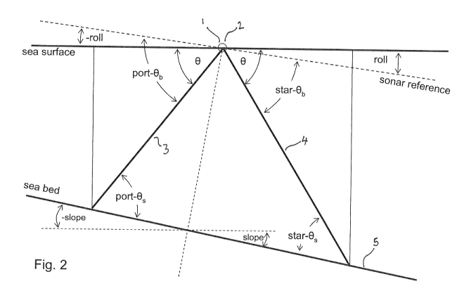
Figure 2 illustrates the various frames of reference used to describe the
methods
described herein. The figure illustrates two sonic rays 3, 4 emitted from
respective
port (left) and starboard (right) transducers 1,2, said transducers shown here
in
juxtaposition, for clarity. These sonic rays 3, 4 illustrate the passage of
sound emitted
from the transducers 1,2 and returning along the same path following
backscattering
from the seabed 5. The angles Os, Ob refer to the backscatter angle (i.e. the
angle
between the direction of travel of the backscattered sonic ray and the seabed)
and the
beam angle (i.e. the angle between the backscattered sonic ray and the
reference plane
of the sonar transducer) respectively. The angles in Figure 2 are preceded by
the
prefixes port- and star- to represent the corresponding angles for a port and
starboard
transducer respectively, for a two-transducer system.
8
CA 02909501 2015-10-14
WO 2014/170213
PCT/EP2014/057311
Characterisation of the roll of the transducers 1,2 is given by the angles
roll and ¨roll
as indicated. The slope of the seabed with reference to a notionally flat sea
surface is
given by the angle slope and ¨slope for the sonic rays 4 and 3 respectively.
Sonar data are collected from a side scan sonar system, typically having two
transducers, one generally collecting data from the port side of a ship and
the other
collecting data from the starboard side of the ship. However, the method is
generally
applicable to systems that might only have a single transducer, or one that
has more
than two transducers. This latter situation might occur when multiple
transducers are
used, collecting data from essentially the same direction, but using a
different sound
frequency. For clarity, the method will be described for a two-transducer
system, and
the skilled addressee will readily be able to apply the method to systems
having more
transducers.
/5
A sonar "ping" is transmitted from the transducer, and the backscattered sound
is
collected as an amplitude trace over time. We denote this trace as d(i, j,t) ,
being the
received amplitude for trace i, transducer j at time t. The trace will
typically be gated
to remove signals received at times earlier than the time for sound to
traverse the
2o shortest distance between the sonar and the seabed. This cutoff time may
be
calculated by a knowledge of the speed of sound in water, and distance to the
seabed.
The distance to the sea bed will typically be known from separate bathymetry
measurements, but in the absence of bathymetry, the sonar traces themselves
may be
used to provide an estimate of depth, allowing unwanted received signal (e.g.
from
25 passing fish shoals) to be readily gated from the signal.
The raw trace data will then typically be subjected to a time-varying gain, to
correct
for geometric signal spreading and attenuation. In some systems this
correction will
be made in the transducer hardware itself, or it may be applied during
software post-
30 processing. Such techniques are well-known in the art.
The amplitude vs. time signal may then be converted to amplitude vs.
transducer
angle, using a geometric relationship of distance to the seabed and distance
travelled
9
CA 02909501 2015-10-14
WO 2014/170213
PCT/EP2014/057311
by the sound signal. Again, these techniques are well-known, and a series of
traces
denoted aobs(0,i, j) of corrected observed amplitude at angle 0 for trace i,
and
transducer j .
These observed amplitude traces need to be corrected for the operating
characteristics
of the transducer, because the signal intensity of the sonic signal
transmitted from the
transducer will vary with angular position, and the sensitivity of transducer
to
detecting the returning sonic signal will also vary with angular position.
This
operating characteristic is usually referred to as a beam function, and it is
a prime
io object of the present invention to provide a method for estimating the
beam function
for the transducers, i.e. effectively calibrating them.
The sonar Beam function and a seabed Scatter function are used in
Normalisation of
the traces in accordance with:
aobs(0)
anor,,,a(0) ¨ [E q.
1]
(0¨ roll) s(0 ¨ slope)
bmaster
S(8m)
Where:
0 (is the) inclination angle of a sonic ray from the sonar to the
seabed measured
+ve downwards from horizontal;
anormal normalised sonar trace amplitude function;
Clain raw sonar trace amplitude function corrected for geometrical spreading
and
absorption;
bmaster port or starboard sonar beam function;
s seabed backscatter function;
roll roll angle of the sonar vehicle;
slope angle from the horizontal of the seabed where a ray intersects the
seabed.
an the 'reference' angle (a constant e.g. 300).
In a two-channel system, for the starboard channel, roll and slope are
typically
designated as being +ve clockwise with respect to, and in the plane
perpendicular to,
the direction of the sonar. For a port channel they are +ve anti-clockwise.
This is the
CA 02909501 2015-10-14
WO 2014/170213
PCT/EP2014/057311
convention used herein, but the skilled address will readily be able to adapt
the
method should a different convention be employed.
The so called reference angle is chosen from a part of back-scatter functions
where
the response as a function of angle is relatively flat. A reference
inclination angle of
300 is a good choice. The division of each coefficient in the scatter function
in the
above equation by the coefficient at an has the effect of normalising the
scatter
function such that its response at 19,,, is unity (OdB). The beam function is
normalised
in this way already (for either the port or starboard channel) when it is
computed.
to
aobs and anormal are usually displayed as functions of time, t, but each datum
is also
associated with an angle, O. As discussed above, the trace normalisation
equation is
applied to the observed trace, aobs(t), at every time index, for t >. 2d / v
(where d is
the distance from the sonar to the seabed and v is the velocity of sound in
water), to
generate the normalised trace, anormadt), whilst avoiding the confounding
effects of
sound waves reflected or back-scattered from sources closer than the seabed.
By way of illustration Figure 3 shows a side scan sonar image (i.e. received
amplitude
data) that has been slant range corrected (i.e. the received angle from the
transducers
2o has been converted to horizontal displacement from the centre-line of
the survey), and
also corrected for geometrical spreading and signal attenuation. The image
data are
not, however, trace normalised and are therefore affected by sonar beam
function and
seabed scatter function. They are also particularly affected by roll, as can
be seen in
the oscillating nature of the signal across the image.
Illustrating the effect of Trace Normalisation, Figure 4 shows the same data
that have
been trace normalised. It can be seen that most of the effects of the sonar's
beam
function, the seabed scatter function as well as the effects of roll have been
eliminated
from the image, and that the image (of a relatively homogeneous area of
seabed) is
3o very uniform, now being a strong function of essentially a single seabed
material.
To be able to compute Trace Normalised traces, the Beam function for the sonar
must
have been determined in some way, and an appropriate seabed backscatter
function
(scatter function) must also have been determined. Two related approaches to
11
CA 02909501 2015-10-14
WO 2014/170213
PCT/EP2014/057311
calculation of beam function are described, allowing a side scan sonar system
to be
calibrated: In one approach, beam function is calculated via a route of
determining a
series of beam sub-functions, leading to calculation of an intermediate seabed
scatter
functions, and eventually a master beam function. Once the sonar beam function
is
determined, seabed scatter functions may subsequently be determined. In a
second
approach, a series of seabed scatter sub-functions are first calculated that
may be
reconciled to determine an intermediate master scatter function and then a
master
beam function. Both approaches are described below.
/o In order to carry out the determination of the beam function, the roll
angle of the
transducer, with respect to the sea bed is measured during the collection of
each of the
sonar traces. The period of roll of the transducers is typically much longer
than the
relevant timescale for transmission and backscatter of the sonic signal, and
so a single
measurement of roll for each sonar trace may usually be used. However, for
more
accurate determinations, e.g. if the roll frequency is high, or the seabed
depth is great,
roll angle may be measured as a function of time, with roll angle as a
function of time
being known for each trace.
Also, if multiple transducers are being used, it is usual that they are
physically
2o attached to the same sonar vehicle and thus have the same roll angle. In
this case, a
single roll sensor may be associated with the sonar vehicle, with the roll
measurement
data being common to all transducers. If the multiple transducers are not
physically
connected in this way, then separate roll sensors may be employed for each
transducer.
Roll will typically be measured with respect to a datum plane, e.g. a
notionally flat sea
surface.
Method 1 ¨ Calibration via Beam Sub-Functions
In one embodiment of the invention, the first step in the process to determine
an
estimate of the beam function is to create a series of beam sub-functions, bmn
for
each transducer, each over a restricted range of transducer angles from
amplitude data
12
CA 02909501 2015-10-14
WO 2014/170213
PCT/EP2014/057311
for a number of traces collected from a rolling transducer. This may be
calculated
according to:
broll _n(19n ¨ roll) = a obs(en) [Eq. 2]
A large number of data for each angular bin in the sub-beam functions are
collected
and averaged. Depending on the amount of roll encountered by the transducers,
a
number of overlapping such sub-beam functions may be calculated that together
span
the operating angular range of the transducers.
io For example, for the first sub-beam function (n=0) a reference angle 00
is chosen to
be equal to em, typically around 300, being the angle where the seabed scatter
function has a relatively flat response. If the minimum and maximum roll
angles
available in the data are denoted as rollm and roll,,nn, then coefficients may
be
estimated for a beam function for the range (On - roll.) to (On -
/5
The process of calculating a beam sub-function is then repeated for n = 1, 2,
3 etc and
then n=-1, -2, -3 etc until the entire operating angular range of the
transducer has been
covered.
2o Figure 5A illustrates a number of such sub-beam functions 99 ¨ 108
representing sub-
beam functions for n = -1 to n =8 for a port-side transducer using data
collected from
a two-transducer side-scan sonar system. Corresponding sub-beam functions 199
¨
207 are shown in Figure 5B for n = -1 to n =7 for a starboard-side transducer.
25 It can be seen that each sub-beam function overlaps with its neighbour,
and that
together, the sub-beam functions span essentially the whole of the operating
angular
range of each transducer.
It can also be seen that the sub-beam functions are displaced from each other,
not
30 forming a continuous beam function.
The next step in the process is therefore to align each sub-beam function with
its
angular neighbour (i.e. to align the sub-beam function for n=0 to the function
for n=1,
13
CA 02909501 2015-10-14
WO 2014/170213
PCT/EP2014/057311
and so on). This may carried out by applying a factor to each function to
minimize
the difference between overlapping sub-beam function regions. When calculating
the
difference function to minimize in this process, a weighting factor may be
applied to
give greater weight to those portions of the sub-beam functions that were
calculated
using the most data.
Once this process has been carried out, composite beam functions are then
created for
each transducer. Figures 6A and 6B illustrate such composite beam functions
for the
port and starboard transducer data of Fig 5, following this sub-beam function
io alignment process. The composite beam functions shown in these figures
has been
further normalised such that the response is shown as OdB at the reference
angle
19m for one of channels (in this example, the port channel) .
These functions are the beam function but referred to as "seed" beam
functions, for
from it a more robust beam function may be computed. The port and starboard
parts
of the seed beam function are associated with their own seabeds.
Because the data for calibration are collected from essentially the same
region of
seabed, having approximately consistent features, the same scatter function
should
2o therefore apply to all (or each) of the beam functions determined. This
is if data are
collected in two directions along the same surveying track, as the port and
starboard
transducers will each gather data from an identical portion of the seabed,
albeit at
different times. For more robust determination of beam functions and seabed
scatter
functions, it is particularly preferred that such data are collected in two
directions
along the same surveying track.
To improve the estimated beam functions, a single intermediate master scatter
function, smaster (e), being the scattering characteristics of the seabed
composited
from the seabeds, used to compute both halves of the seed beam function, is
3o calculated. This function may be calculated according to:
aobs (61)
S mt_master (0 ¨ slope) ¨ [Eq. 3]
bseed (0 ¨ roll)
14
CA 02909501 2015-10-14
WO 2014/170213
PCT/EP2014/057311
Where a05 (8) are the observed amplitude data, and bseed (0) is the "seed"
beam
function estimated in the previous method step. The slope term may be
introduced for
seabed measurements where the seabed is not flat, with slope being the seabed
angle,
if the seabed is not horizontal. This may be determined, for example, from
bathymetry data.
A common seabed scatter function calculated from the data, is therefore used
to
determine the master beam function for each transducer according to:
a ___________________________________ obs (8)
knasõr(0 ¨ roll) ¨ [Eq. 4]
siõ,,õr (8¨ slope)
Each coefficient in the beam function that emerges is then divided by the
coefficient
for bmaster(0m) for one of the transducers (e.g. the port one, for a two-
transducer
system) to normalise the beam function such that its response at Am (for the
channel
selected as the standard) is unity (as a factor) or OdB. Master beam
functions, 400 and
401, calculated in this way are shown in Figures 7A and 7B for the port and
starboard
transducer data of Figure 5.
The seabed back-scatter function 500 calculated from these data is illustrated
in
Figure 8.
The process may be exemplified in more detail, and including practical
computational
guidance, as follows:
Whilst the equations above are cast in terms of continuous angular variables,
it is of
practical value that angular data is quantised for purpose of calculation.
Values for the
coefficients that emerge from the use of the equations that follow (2 ¨5) are
binned as
functions of the angle 0 (in say 1 bins), and arithmetic means computed for
each bin
from data in as many contiguous traces as practicable for good estimates of
coefficients.
As discussed above, the first function that is required is an approximately
correct
beam function that we refer to as the 'seed' beam function. From this a more
robustly
CA 02909501 2015-10-14
WO 2014/170213
PCT/EP2014/057311
determined 'master' beam function is computed. And from this in turn an
appropriate
number of seabed scatter functions may be determined. Sonar beam functions
(transmit and receive) are sometimes measured in a laboratory, in which case
such a
function would serve as a suitable seed beam function. However, all too
easily, not
quite the correct measurement is made. The need for lab measurement can be
circumvented by extracting a seed beam function from an image making use of
accompanying sonar vehicle roll data, and this process is described next.
A beam sub-function (a beam function over a restricted range of angles) may be
extracted from an ensemble of contiguous traces in an image affected by a
sufficient
io amount of sonar vehicle roll using:
brou_n(en - roll) = aobs(en) 2
Multiple beam sub-functions extracted piecemeal may subsequently be reconciled
to
form a single composite beam function (encompassing all angles represented in
the
data).
For the first sub-beam function, n =0. 00 is the so called 'reference angle',
On,. If the
maximum and minimum roll in the ensemble of traces from which the beam
function
is extracted are roll, and roll,, n respectively (e.g. .50), then
coefficients may be
estimated for a beam function for the range (On - rollõ.,) to (On - roknin).
However the
2o number of data used to compute coefficients near the ends of this range
will be small
and therefore the range of roll values over which useful coefficients are
extracted
must be restricted to values yielding good estimates over the range.
The process is repeated subsequently for n = 1, 2, 3..., and then -1, -2, -3
..., in which
19n is set to 00 + n. (roll. - )/2. This yields a number of discrete beam
sub-
function which overlap at their ends (As already shown in Figure 5). The sub-
functions may be reconciled in the following way: Begin a composite function
with
the sub-function 0 (n = 0). The composite function grows by progressively
reconciling the other sub- functions to it by computing factors to map
subsidiary sub-
3o functions (n = 1, 2, 3...; then -1, -2, -3...) onto the emerging
composite function, from
the values of coefficients where a sub- function overlaps the composite. The
factors
are appropriately weighted according to the number of data used to compute the
values of coefficients. The factors are applied to coefficients such that the
coefficients for sub- function ml map onto the coefficients for sub- function
ml ¨ 1.
16
CA 02909501 2015-10-14
WO 2014/170213
PCT/EP2014/057311
In this way a composite beam function emerges for the full range of angles
encountered in the traces from which the beam function is extracted (Figure
6).
A minimum amount of roll for this approach to beam function extraction to work
adequately is; roll, a, and rollmin approximately or 3)0 (for 1 angular
bins),
although adequate results may be obtained for roll angles as little as - 10. A
correction
for seabed slope cannot readily be made while applying this process and
therefore the
seabed should preferably be flat for the traces from which this function is
extracted.
This function then serves as the 'seed' beam function in the process of
extracting a
io master beam function.
The master beam function
To extract a master beam function from an ensemble of contiguous traces with
respect
to a 'seed' beam function, a temporary intermediate-master scatter f function
n is
extracted first using:
sint-master(19 - slope) = aobs(e) / bseed(60 - roll) [Eq. 3]
where:
Sint-master (is the) intermediate-master scatter function;
bseed seed beam function.
The seed beam function (e.g. figure 6) is the starting function and is an
approximately
correct beam function for the sonar system. It may be derived from measurement
or
calculation from theory, or by distillation from an image utilising roll
information as
just described.
The master beam function is then extracted with respect to the intermediate-
master
scatter function using:
bmaster(0 - roll) = a0b5(6) 5int-master(0 - slope) [Eq. 4]
3o Each coefficient in the beam function that emerges is now divided by the
coefficient
for bmasterfem) for one of the channels (e.g. the port one) to normalise the
beam
function such that its response at 60,,, (for the channel opted as the
standard) is unity (as
a factor) or OdB (figure 7).
17
CA 02909501 2015-10-14
WO 2014/170213
PCT/EP2014/057311
This is the master beam function. Note that the port and starboard halves of
the
master beam function are both extracted with respect to a common intermediate-
master scatter function. In this way there is robustness in the internal
consistency
between the port and starboard beam function that is not present in the seed
beam
function derived directly from the roll data. This is one of the reasons the
(seed) beam
function derived from roll data should be subsequently superseded to generate
the
master beam function. Having computed the master beam function, the
intermediate-
master scatter function is now discarded. The master beam function is a
property of
the sonar (and also a function of sonar transmission frequency for a multi-
frequency
system, and possibly power output). Once a good master beam function has been
computed it may be filed for re-use with other data acquired with the same
system,
and only replaced should an opportunity arise to compute a more accurate one
with
better (e.g. more) data.
Figure 7 shows beam functions for the port and starboard channels. Note that
these
are different. Every sonar for a given manufactured system may look and be
intended
to be identical but in fact each (channel) is acoustically unique in a way
that is
statistically significant (the beam function constitutes a sonar's unique
signature).
There will invariably be readily visibly discernible deleterious effects if
another
2o sonar's beam function is inappropriately used.
Scatter functions
Scatter functions (one or more) are extracted with respect to the master beam
function
using:
- slope) = a0b1(19) bmaster09 - roll) [Eq. 5]
The first scatter function would normally be computed from the same data used
to
compute the master beam function. (figure 8). The scatter function in figure 8
is
shown normalised with respect to its value at Om.
The traces selected for extracting a trace normalisation (TN) function should
be for an
area of seabed that is uniform; and ideally for extracting the master beam
function
(and the first scatter function) the seabed should be the most common for the
survey
area.
18
CA 02909501 2015-10-14
WO 2014/170213
PCT/EP2014/057311
Figures 7 and 8 illustrate a set of TN functions for a single frequency I
monochrome
sonar. (Multiple frequency data require the computation of a similar TN
function set
for each frequency). Coefficients are shown as dB rather than as amplitude
factors
(CoefdB = 20*log10(factor)).
The effect of applying trace normalisation illustrated in figures 3 and 4
shows that the
effects of beam function and scatter function have been very satisfactorily
compensated for, and quite impressively a strong effect of sonar vehicle roll
in figure
3 prior to trace normalisation is all but absent in the trace normalised image
in
figure 4.
The scatter function is dependent on seabed material. A single scatter
function
generated for the most common seabed material in a survey area will often do
an
adequate job over the entire survey area. But disparate seabeds respond
differently
and have different scatter functions. The shape of the back-scatter function
is affected
by the strength of back-scattering by the seabed (the roughness of the
seabed). If a
survey area includes seabeds with large variations in back-scattering strength
then
additional scatter functions can be extracted to enable TN to perform more
effectively.
Method 2 ¨ Calibration via Seabed Scatter Sub-Functions
In this second, but related embodiment of the invention, an alternative route
to
computing a master beam function is via an intermediary seabed scatter
function
extracted directly from an ensemble of contiguous traces in an image affected
by a
sufficient amount of sonar vehicle roll, in a way similar to that described
and
illustrated already for directly extracting a seed beam function.
In this method, a series of scatter sub-functions (scatter function determined
over a
3o restricted range of inclination angles) may be extracted from an
ensemble of
contiguous traces in an image affected by roll using:
sron_n(en + roll) = aobs(On+ roll) [Eq. 6]
19
CA 02909501 2015-10-14
WO 2014/170213
PCT/EP2014/057311
This process is analogous to the determination of beam sub-functions in Method
1, as
described above, with reference to Equation 2.
The calculations may best be carried out by quantising the angles into a
series of
discrete "bins", having an arbitrary bib-width, as described above. For every
trace
used to extract a scatter sub-function, the positions on the trace are found
for which
acoustic rays fall within the range of angles with the seabed, On + roll
half bin
width, taking seabed slope into account. The corresponding amplitude values,
a0b1(0õ-F roll), are binned (i.e. assigned to a corresponding bin) for use in
calculating
io the coefficient, Sroll n(en + roll). The effect of the beam function on
the extracted
back-scatter sub-function is a constant for the restricted range of angles
represented
by the amount of sonar vehicle roll.
Multiple scatter sub-functions may this be extracted piecemeal, in a way
analogous to
the extraction of multiple beam sub-functions as described above, and
illustrated in
Figure 5. These scatter sub-functions may then be subsequently reconciled to
form
port and starboard composite scatter functions (encompassing the full range of
inclination angles represented in the data). Reconciliation may be carried out
by
considering the overlapping portions of adjacent scatter sub-functions, and
scaling the
2o sub-functions such that the difference between adjacent sub-functions is
minimised in
the overlapping portion. Again, the scaling may be weighted depending on the
number of datapoints available for calculation. The details are analogous to
those
already described already for constructing a beam function according to Method
1.
The separate port and starboard scatter functions that emerge are then
combined (e.g.
by averaging the two scatter functions) to form a single seabed scatter
function.
This scatter function will have an arbitrary value at the reference angle.
However,
this does not matter because this function is to be regarded as an
intermediate master
scatter function from which a master beam function may be computed in the way
3o described in a previous section (equation 4), thereby effecting
calibration of the sonar
system.
CA 02909501 2015-10-14
WO 2014/170213
PCT/EP2014/057311
Remarks
A scatter function is dependent on seabed material. A single scatter function
generated for the most common or the most median seabed material in a survey
area
will sometimes do an adequate job if used to correct data over the entire
survey area.
But disparate seabeds respond differently and can have very different scatter
functions. The shape of the back-scatter function is affected by the strength
of back-
scattering by the seabed (the roughness of the seabed). If a survey area
includes
disparate seabeds with large variations in back-scattering strength then
additional
scatter functions can be extracted to enable TN to perform more effectively.
If for a
survey area more than one scatter function is extracted then a system may be
configured to decide which scatter function to apply (or between which two
scatter
functions to interpolate). Another option is to continuously update an
adapting scatter
function computed from traces in the vicinity of the trace for which a
correction for
scatter function is being applied.
/5
A scatter function constitutes a seabed's characteristics and a collection of
scatter
functions can provide a basis for seabed classification (similar to Hughes-
Clarke,
1994). If multiple scatter functions are extracted to represent all seabed
types in a
survey area, a process can determine at each pixel the scatter function that
most
2o closely matches the seabed. In so doing, a seabed classification is
effectively made.
If the extraction of scatter functions is supervised by a suitably experienced
geoscientist, ideally with access to ground truth information, image seabed
classification constitutes a geo-interpretation of the image, achieved as a by
product of
applying TN processes. The initial classification may be non-linear filtered
to provide
25 a smoothing effect on classification decisions that might in some places
be noisy.
It has been assumed in the fore-going that a sonar trace is associated with a
single
value of sonar vehicle roll. This is typically a good approximation in short
range
surveying where the frequency of vehicle roll is much less than the trace or
pulse
3o repetition frequency. However where this condition is not met (e.g. for
long range
soundings), the analysis must be extended to consider roll as a function of
time. For
each trace, the transmit part of the beam function will be associated with a
single
value of roll, but the receive part will be associated with roll that varies
with time.
21
CA 02909501 2015-10-14
WO 2014/170213
PCT/EP2014/057311
A sonar beam function may be extracted from sonar image trace data and sonar
vehicle roll data. Subsequently seabed back-scatter functions may be extracted
for
disparate seabeds from sonar trace data, with respect to the beam function.
The Trace
Normalisation process can then account for the effects of vehicle roll and
seabed slope
when correcting for sonar beam and seabed scatter functions. This yields a
recovery
of true signal amplitude (with respect to the reference angle) and image
texture,
representing seabed material across the full width of side scan sonar imagery,
un-
confounded by the effects of sonar beam (and roll) and seabed back scatter
functions
(and seabed slope). As an alternative route to extracting a sonar beam
function from
io sonar image data and sonar vehicle roll data; instead a seabed back-
scatter function
may be extracted from sonar image data and sonar vehicle roll data. This may
then
serve as an intermediary function from which a beam function is extracted from
image
trace data, with respect to the scatter function.
References
Chesterman, W. D., Clynick, P. R. and Stride, A. H., An acoustic aid to sea-
bed
survey, Acustica 8: 285-290, 1958.
Hughes Clarke, J.E., Toward remote seafloor classification using the angular
response
of acoustic backscattering: a case study from overlapping GLORIA data, IEEE
Journal of Oceanic Engineering, 19, 112-127, 1994.
Hughes Clarke, J.E., Danforth, B.W., Valentine, P., Areal seabed
classification using
backscatter angular response at 95 kHz., NATO SACLANTCEN Conference
Proceedings Series CP-45, High Frequency Acoustics in Shallow Water,
Lerici, Italy, pp. 243-250, 1997.
3o Hughes Clarke, J. E., Seafloor characterization using keel-mounted
sidescan: proper
compensation for radiometric and geometric distortion,
Canadian Hydrographic Conference, May, 2004.
22