Note: Descriptions are shown in the official language in which they were submitted.
CA 02914912 2015-12-09
WO 2015/023265
PCT/US2013/054752
TITLE OF THE INVENTION
A Simulation-To-Seismic Workflow Construed From Core Based Rock Typing and
Enhanced By Rock Replacement Modeling
BACKGROUND OF THE INVENTION
1. Field of the Invention
[0001] The present invention generally relates to the field of computerized
reservoir flow
modeling, and more particularly, to a system and method configured for
verifying rock type
flow units from flow simulation.
2. Discussion of the Related Art
[0002] Seismic to simulation is the process and associated techniques used to
develop highly
accurate static and dynamic 3D models of hydrocarbon reservoirs for use in
predicting future
production, placing additional wells, and evaluating alternative reservoir
management
scenarios. Seismic to simulation enables the quantitative integration of all
field data into an
updateable reservoir model built by a team of geologists, geophysicists, and
engineers. Key
techniques used in the process include integrated petrophysics and rock
physics to determine
the range of lithotypes and rock properties, geostatistical inversion to
determine a set of
plausible seismic-derived rock property models at sufficient vertical
resolution and
heterogeneity for flow simulation, stratigraphic grid transfer to accurately
move seismic-
derived data to the geologic model, and flow simulation for model validation
and ranking to
determine the model that best fits all the data. This process is successful if
the model
accurately reflects the original well logs, seismic data and production
history. However,
seismic to simulation is not always successful as seismic data may be
inaccurate, incomplete,
or all together not available.
[0003] Accordingly, the disclosed embodiments propose that a petrophysical
model with or
without the influence of geologic facies be used to identify rock type flow
units through flow
simulation, which may then be used to guide the spatial (geometric)
interpretation of geologic
facies or rock types through a closed loop workflow (i.e., simulation to
seismic). As a result,
one gains information about static properties from dynamic simulation and
their relationship to
flow units.
1
CA 02914912 2015-12-09
WO 2015/023265
PCT/US2013/054752
BRIEF DESCRIPTION OF THE DRAWINGS
[0004] Illustrative embodiments of the present invention are described in
detail below with
reference to the attached drawing figures, which are incorporated by reference
herein and
wherein:
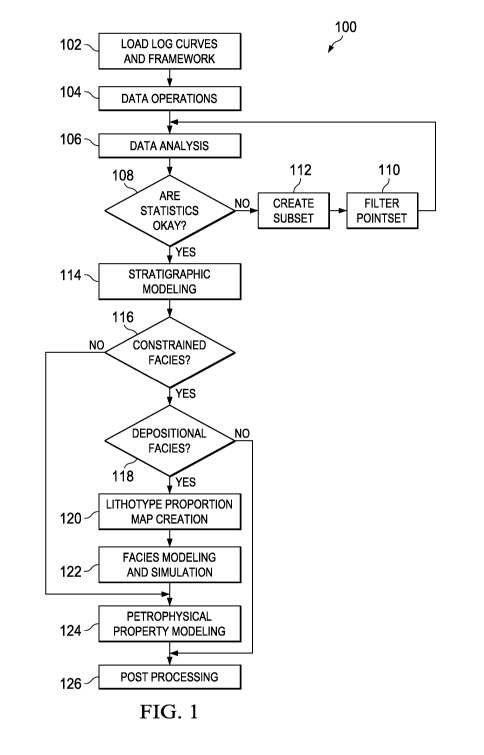
[0005] Figure 1 illustrates an example of a traditional earth modeling
workflow in accordance
with the disclosed embodiments;
[0006] Figure 2 illustrates an example of the traditional earth modeling
workflow with a
simulation to seismic component in accordance with the disclosed embodiments;
[0007] Figure 3 illustrates an example of a probability plot in accordance
with the disclosed
embodiments;
[0008] Figure 4 illustrates an example of a cross plot used for defining
petrofacies in
accordance with the disclosed embodiments;
[0009] Figure 5 illustrates an example of an interface depicting a comparison
of four different
facies model in accordance with the disclosed embodiments;
[0010] Figure 6 illustrates an example of four relative permeability curves in
accordance with
the disclosed embodiments;
[0011] Figure 7 illustrates an example of a result/validation interface in
accordance with the
disclosed embodiments;
[0012] Figure 8 illustrates an example of an oil production rate plot in
accordance with the
disclosed embodiments;
[0013] Figure 9 illustrates an example of a cumulative oil production plot in
accordance with
the disclosed embodiments; and
[0014] Figure 10 is a block diagram illustrating one embodiment of a system
for implementing
the disclosed embodiments.
2
CA 02914912 2015-12-09
WO 2015/023265
PCT/US2013/054752
DETAILED DESCRIPTION
[0015] The disclosed embodiments include a system and method for determining
rock types/
rock type flow units from flow simulation. As referenced herein a flow unit is
a
stratigraphically continuous interval of similar reservoir process speed that
maintains the
geologic framework and characteristics of rock types. Rock types are units of
rock deposited
under similar conditions which experienced similar diagenetic processes
resulting in a unique
porosity-permeability relationship, capillary pressure profile and water
saturation for a given
height above free water in a reservoir.
[0016] The disclosed embodiments and advantages thereof are best understood by
referring to
lo Figures 1-10 of the drawings, like numerals being used for like and
corresponding parts of the
various drawings. Other features and advantages of the disclosed embodiments
will be or will
become apparent to one of ordinary skill in the art upon examination of the
following figures
and detailed description. It is intended that all such additional features and
advantages be
included within the scope of the disclosed embodiments. Further, the
illustrated figures are
only exemplary and are not intended to assert or imply any limitation with
regard to the
environment, architecture, design, or process in which different embodiments
may be
implemented.
[0017] Figure 1 illustrates an example of a traditional earth modeling
workflow 100 in
accordance with the disclosed embodiments. The depicted process may be
implemented using
software such as, but not limited to, DecisionSpace0 Earth Modeling software
available from
Landmark Graphics Corporation. DecisionSpace0 Earth Model delivers 2D and 3D
earth
modeling and visualization technologies for reservoir to basin-scale projects.
The technology
includes state-of-the-art data analysis, stratigraphic gridding, facies and
petrophysical property
modeling and probabilistic uncertainty analysis to deliver simulation-ready
models.
[0018] The earth modeling workflow 100 involves the construction of a
petrophysical model,
which is spatially constrained by defined facies. A facies is a body of rock
with specified
characteristics. These facies are usually derived from examination of
petrophysical and rock
physics based relationships observed in well logs or geophysical logs (step
102). The
petrophysical model are employed to help reservoir engineers and geoscientists
understand the
rock properties of the reservoir, particularly how pores in the subsurface are
interconnected,
controlling the accumulation and migration of hydrocarbons.
3
CA 02914912 2015-12-09
WO 2015/023265
PCT/US2013/054752
[0019] As shown in the depicted earth modeling workflow 100, after the well
log and a
selected framework is loaded and analyzed (steps 104-112), the earth modeling
workflow 100
performs stratigraphic modeling (step 114). Stratigraphic modeling includes
creating a grid
that is used to model the sub-horizontal surfaces and seams. As part of the
process, in certain
embodiments, a user may specify the layering style, number of layers, or
thickness within each
interval for stratigraphic modeling. A user may also alter the size and areal
extent of the
selected framework and adjust the rotation of the framework.
[0020] After stratigraphic modeling, the earth modeling workflow 100 includes
steps for
constraining the model with respect to depositional facies (step 118). This
includes creating a
lithotye proportion map (i.e., a vertical proportion matrix) (step 120). The
lithotye proportion
map consists of lithology curves representing the facies proportions
lithotypes (grouped facies)
locally for every blocked layer throughout the model. The purpose of the
lithotye proportion
map is to introduce secondary information, e.g., various trends, in the data
to enable better
control over facies boundary conditions.
[0021] The lithotye proportion map is used as input for facies modeling and
simulation (step
122). This step involves simulating facies onto the grid. The object is to
create a high-
resolution definition of the vertical and lateral facies relationship within
each stratigraphic
reservoir interval. Multiple facies simulations could be computed using
stochastic simulation
methods.
[0022] After facies modeling and simulation are completed, petrophysical
property modeling
(step 124) is used to populate the facies models with petrophysical properties
(porosity,
permeability, water saturation, etc.). The petrophysical property modeling is
configured to
enable users to construct multiple realizations of distributed petrophysical
properties at any
level of detail including by individual facies and by individual interval.
Additionally, in
accordance with the disclosed embodiments, petrophysical property modeling may
also be
performed on models without facies constraints (step 116). Accordingly, this
step includes the
option to include or not include lithotype constraints. For instance, in one
embodiment, if
lithotype constraints are not included, petrophysical modeling can be
performed inside the
stratigraphic grid without using a facies model.
[0023] The earth modeling workflow 100 further includes post processing
analysis (step 126).
For example, in accordance with the disclosed embodiments, probabilistic
uncertainty analysis
may be performed using all the multiple realizations of facies and
petrophysical properties
4
CA 02914912 2015-12-09
WO 2015/023265
PCT/US2013/054752
allowing the user to select any quantile or set of quantiles to be used for
subsequent analysis
like flow simulation. Probability maps may be generated and visualized for
thresholds defined
by any quantile or for a range of quantiles. Further, stochastic volumetric
calculations can be
derived generating a variety of useful metrics such as pore volume, original
hydrocarbons in
place, and recoverable hydrocarbons. Calculations can support oil-water, gas-
water, and gas-
oil-water contacts, as well as saturations above contacts.
[0024] Figure 2 illustrates an example of a modified earth modeling workflow
200 with a
simulation to seismic component (steps 128-140) in accordance with the
disclosed
embodiments. In the depicted embodiment, following post processing, the
simulation to
seismic component provides a feedback loop of the simulation results that may
be used to
validate against seismic data. As shown in the modified earth modeling
workflow 200, the
simulation to seismic component may be performed on models that are
constrained with
respect to depositional facies and those that are unconstrained with respect
to depositional
facies.
[0025] If simulation to seismic is enabled (step 128), the modified earth
modeling workflow
200 proceeds to use empirical or deterministic petrofacies definition at each
node (step 130).
For instance, in one embodiment, rock mechanical and petrophysical rock
properties are
measured in physical or digital laboratories, outside of the numerical
modeling environment,
such that relative permeability, capillary pressure, bulk modulus, and shear
modulus are
obtained. A corollary of the direct core measurements performed in the
laboratory is the
definition of rock types based on analysis of petrographic, mechanical and
petrophysical
properties, which may be classified according to ranges of
porosity/permeability relationships.
[0026] For example, in one embodiment, after defining a grid or subset of grid
and performing
facies modeling (step 122) and petrophysical modeling (step 124) to determine
realization of
porosity, the modified earth modeling workflow 200 performs post-processing
analysis (step
126), which includes generating a probability plot, as illustrated in Figure 3
in which
probability is on the y-axis and recoverable stoic is on the x-axis, to enable
identification of
the most likely realization to conduct the simulation to seismic process. The
petrophysical
realizations may be ranked volumetrically to determine a P10, P50 and P90
candidates for
fluid flow simulation. P90 refers to proved reserves, P50 refers to proved and
probable
reserves and P10 refers to proved, probable and possible reserves. In one
embodiment, the
process may be configured to automatically select one of the rankings for
performing fluid
5
CA 02914912 2015-12-09
WO 2015/023265
PCT/US2013/054752
flow simulation. For example, the process may be configured to automatically
select the P50
candidate for each of the models (models that are constrained with respect to
facies and the
models that are unconstrained with respect to facies) for performing fluid
flow simulation.
[0027] After post-processing, the process utilizes empirical relations for
determining actual
petrofacies definition (step 130). As an example, Figure 4 illustrates a cross
plot 400 that may
be used for defining petrofacies in accordance with the disclosed embodiments.
The cross plot
400 plots permeability on the y-axis and porosity on the x-axis, and includes
four different
facies as indicated by the four different shapes. For example, in one
embodiment, the circles
represent shale, the diamonds represent high porosity siltstone, the triangles
represent low
porosity siltstone, and the squares represent dolomite. The process is
configured to apply a
rigid permeability cutoff to define the four petrofacies. For example, in one
embodiment,
based on concentration, shale is determined to have a permeability cutoff at a
lower bound of 0
millidarcy (md) and an upper bound of 20 md, low porosity siltstone is
determined to have a
permeability cutoff between 20 md and 100 md, dolomite is determined to have a
permeability
cutoff between of 100 md to 500 md, and high porosity siltstone is determined
to have a
permeability cutoff between 500 md and above.
[0028] Once the process determines the different interface ranges based on
permeability, the
process applies them to the selected models/volumes to derive volumes of
petrofacies. As an
example, Figure 5 illustrates an interface depicting a comparison of four
different facies
models/volumes with the applied permeability cutoffs in accordance with the
disclosed
embodiments. Volume 502 illustrates a traditional depositional facies model
with four
different facies that are consistent with available seismic data. Volumes 504,
506, and 508
illustrate petrophysical models that are constrained and unconstrained with
respect to
depositional facies, but are still constrained with respect to seismic. In
particular, volume 504
illustrates a petrophysical model that is constrained with respect to
depositional facies with the
applied permeability cutoffs. Volumes 506 and 508 illustrate petrophysical
models that are
unconstrained with respect to depositional facies with the applied
permeability cutoffs.
Volume 506 illustrates all four petrofacies types (shale, low porosity
siltstone, high porosity
siltstone, and dolomite), whereas volume 508 illustrates only three
petrofacies type in which
low porosity siltstone and dolomite, based on their overlap, are combined into
one petrofacies
type due to these rock types having similar flow properties on macro scale.
6
CA 02914912 2015-12-09
WO 2015/023265
PCT/US2013/054752
[0029] Following the above step, the process assigns relative permeability
curves at a geo-
cellular level to each of the petrofacies definition, thus, defining
petrofacies with respect to
permeability. An example of four relative permeability curves describing the
water-oil system
corresponding to the four identified depositional facies is illustrated in
Figure 6. The relative
permeability curves depict rock-fluid and fluid-fluid interaction. For
example, the relative
permeability curves 610 indicate low water retention on the residual and high
associated
velocity in terms of where it intersects the remaining permeability curves. In
some
embodiments, capillary pressure curves, if available, may also be assigned to
individual grid
cells of selected candidate.
[0030] Once the relatively permeability curves are assigned at a geo-cellular
level to the
petrofacies definition, then at cellular level, the process assigns relative
permeability to each
node/cell according to the petrofacies definition (step 132). Relative
permeability defines the
rock-fluid and the fluid-fluid interaction that occurs in the reservoir.
[0031] The process then performs flow simulation (step 134) using flow
simulation software
such as, but not limited to, Nexus reservoir simulation software available
from Landmark
Graphics Corporation. In certain embodiments, the process may receive certain
parameters for
performing the flow simulation such as, but not limited to, fluid reservoir
constants, water
properties, stock tank density, formation volume factors and viscosities,
standard conditions,
and equilibrium data. Additionally, certain geomechanical characteristics of
the porous media
may be omitted, inferred, or assumed. For example, the process may infer rock
type
classification if rock deformation is included.
[0032] Once flow simulation is complete, results validation and analysis may
be performed
(step 136). As an example, Figure 7 illustrates a result/validation interface
700 in accordance
with the disclosed embodiments. Images 702 and 706 of the result/validation
interface 700
depicts seismic that is underneath saturation results for the two different
cases shown in the
corresponding images 704 and 708 on the right hand side of the
result/validation interface 700.
Image 704 depicts the four depositional facies assignment as described above,
whereas image
708 depicts the scenario in which only three depositional facies are utilized
as described
above. Image 702 illustrates a snapshot of the generated flow simulation
results considering
depositional faces as a constraint, which were further constrained by the
determined
petrofacies definition. In contrast, image 706 illustrates the generated flow
simulation results
corresponding to petrofacies definitions that were unconstrained with respect
to depositional
7
CA 02914912 2015-12-09
WO 2015/023265
PCT/US2013/054752
facies. As can be seen from the image 702, as the simulation progresses
through time, there
are areas that the flow will travel through quicker, which corresponds to
facies definition in
images 704. Thus, the fluid front is honoring the geometry of the depositional
facies, so the
depositional facies maintain a geometric constraint. Image 706, as previously
stated,
represents the results corresponding to petrofacies definitions that were
unconstrained with
respect to depositional facies. There, the fluid front is a bit more jagged
than the constrained
model (image 702) and there is an implication of increased tortuosity in this
system because
the permeability is a bit more sporadic in their occurrence, a lot less
definition, and as a result,
the flow deviates due to the quick change in relative permeability assignment
on a cell by cell
level.
[0033] The process can further be configured to analyze/validate simulation
production
profiles. For example, Figure 8 illustrates an example of an oil production
rate plot 800
corresponding to the above example. The oil production rate plot 800 graphs
oil production
rate on the y-axis against time in years on x-axis. The oil production rate
plot 800 depicts
three oil production rates that correspond to different scenarios. For
example, the curve 810
corresponds to a model that is constrained with respect to depositional
facies. As shown,
during the first few years (2013-2015), oil production is rather stable.
Following this period, it
converges with the curve 820 and curve 830, and there is a decrease in
production rate. Curve
820 and curve 830 correspond to models that are unconstrained with respect to
depositional
facies, but instead use the determined petrofacies definitions with the
permeability cutoffs for
assigning relative permeability. As depicted, during the same time period
(2013-2015) where
there is a more stable production rate under the constrained model (curve
810), the production
rate of the unconstrained models are undulating. This undulation in production
is expected
because the pressure field would not have developed as easily or as quickly in
a scenario
where the fluids are more dispersed due to where and how relative
permeabilities with very
hard permeability cutoffs are being applied at such discrete numerical values
of permeability.
Thus, curve 820 and curve 830 are rather undulating and more perturbed as
expected with
dispersed flow in a more dispersed medium having interchanging fluid
properties due to the
relative permeability assignments. However, after 7 years of production as the
production
plots approach the year 2020 in the simulation, curve 820 and curve 830
converge with respect
to the initial model (curve 810), which had a depositional facies constraint.
8
CA 02914912 2015-12-09
WO 2015/023265
PCT/US2013/054752
[0034] The process may further be configured to validate the simulated
cumulative oil
production results as illustrated in a cumulative oil production plot 900
shown in Figure 9.
The cumulative oil production plot 900 graphs cumulative oil production on the
y-axis against
time in years on the x-axis. Curve 910 corresponds to a model that is
constrained with respect
to depositional facies. Curve 920 represents an unconstrained model with
respect to
depositional facies having three defined petrofacies types, whereas the curve
930 represents an
unconstrained model with respect to depositional facies having four defined
petrofacies types.
The cumulative oil production plot 900 indicates that for this particular
model, the simulation
could have used the unconstrained model with respect to depositional facies
having only three
defined petrofacies types (curve 920) as opposed to using the using
unconstrained model with
respect to depositional facies having four defined petrofacies types (curve
930) because the
curve 920 more closely matches the model that is constrained with respect to
depositional
facies (curve 910). Thus, in certain embodiments, the process could be further
optimized by
omitting one or more depositional faces definitions.
[0035] Additionally, as depicted in the cumulative oil production plot 900,
the process further
validates that in the event that a model that is constrained with respect to
depositional facies is
unavailable for this data set, as represented by curve 910, the determined
petrofacies
definitions could be used, as represented by curve 920 and curve 930, due to
the similarities in
the simulated cumulative oil production results after seven simulated years in
production.
[0036] With reference back to Figure 2, in one embodiment, the modified earth
modeling
workflow 200 is configured to perform rock replacement modeling 138 as part of
the results
validation and analysis process 136. During the step, the process uses the
prior knowledge of
laboratory derived petrophysical relationships in combination with the
visualized flow field to
identify Rock types as flow units based on preferential, segregated or
isolated (no flow)
regimes, at varying degrees. The interpretation of reservoir scale rock type
flow units entails
the inference of stratification from flow. The construed workflow also permits
the creation of
rock property volumes as an inverse modeling approach. Because the effects of
porous media
stratification on relative permeability is known; the relative permeability
curves, as described
above, generated as a result of laboratory experiments on cores with
established Rock types
would have qualitative and quantitative characteristics associated with
multiphase flow. These
characteristics are demonstrated to be consequences of layering in the porous
media. Thus,
analogous to performing fluid replacement modeling to predict rock physics
attributes, the
9
CA 02914912 2015-12-09
WO 2015/023265
PCT/US2013/054752
disclosed embodiments may be configured to use "rock replacement modeling" to
produce
rock property volumes from computed saturation profiles. For instance, given
the saturation
profiles, as well as knowledge of the matrix, water and hydrocarbon densities,
the Wyllie
density of the saturated rock volume may be computed as follows:
[0037] Psat = Pmatrix(1 - (P) PvvSvv(P Phc(1 - Sw)(P
[0038] The Wyllie density of the saturated rock volume may then be input into
the Biot-
Gassman equations to obtain Vp (compressional wave velocity) and Vs (shear
wave velocity)
[0039] Vp = 3
iKsat Alsat
Psat
Psat
[0040] Vs = I¨
Psat
[0041] along with the saturated bulk modulus (Ksat) and the saturated shear
modulus (iusat);
which is equivalent to the shear modulus of dry rock (lathy) since it is well
understood that
shear waves are not affected by pore fluid -s-waves cannot be propagated
through fluids.
[0042] This leads to time-dependent volumes of Vp and Vs being created which
allows
volumes of P-Impedance (PI)
[0043] PI=pV
[0044] where (p) is density and (V) is seismic velocity as well as Poisson's
Ratio
1 (v12,-2v0
[0045] a = ________
2 (v12,- v)
[0046] to be created. Use of a crossplot to enhance the analysis of these
individual recurrent
data volumes (P-impedance-Poisson's Ratio-Gamma Ray, P-impedance-VpNs-Gamma
Ray,
P-Impedance-VpNs-density or others) would permit the quantification of facies
groups from
time-dependent rock property volumes constructed after flow simulation which
would be
verified through a direct comparison of static acoustic impedance to
dynamically derived
acoustic impedance obtained from the simulation to seismic process using a
rock replacement
model.
[0047] In the absence of rock replacement modeling 138, the dynamic simulation
results may
be validated with respect to static acoustic impedance volume derived from
seismic through
visual analysis 140 of dynamic saturation profile with respect to static
acoustic impedance.
CA 02914912 2015-12-09
WO 2015/023265
PCT/US2013/054752
The petro-facies definitions may be altered by the user such that the dynamic
fluid simulation
is more coincident with the structural and conductive properties of the
acoustic impedance
constraint or the depositional facies model is redefined so that the static
model yields a
dynamic simulation which is a better match to production history.
[0048] Additionally, whether performing rock replacement modeling 138 or
visual analysis
140, in both embodiments, the results validation and analysis step 136 may be
modified based
on the minimization of the relative difference between production history and
the simulations
obtained from the simulation to seismic workflow. A subsequent iteration of
facies modeling
and simulation (indicated by the dash lines shown in Figure 2) may be
undertaken if a
depositional facies model exists (step 118). In the absence of a depositional
facies model, a
subsequent iteration of the empirical petro-facies definitions/assignments
(step 130) may be
performed in order to more accurately define the hydraulic flow units within
the reservoir
volume; and as an iterative process re-execute the simulation with which the
results may be
verified against seismic acoustic impedance. The aforementioned subsequent
iterations of the
workflow may be performed until the static earth model yields a dynamic
simulation having a
better match to production history.
[0049] Whether in the presence of or in the absence of crossplot analysis of
rock property
volumes the Rock type may be identified along an existing well trace or a new
well trace may
be interpreted (a pseudo well) that allows a rock type log to be created. This
is achieved by
creating a Rock type property volume based on petrophysical cutoffs. The Rock
type log
would be constructed of unique interpreted index values of Rock type
intersected by the well
trace. Once created, and calibrated with respect to seismic acoustic
impedance, it may then be
incorporated into a subsequent iteration of building an earth model which
would involve using
the Rock type modeling, as opposed to facies modeling, to constrain the
spatial (geometric)
propagation of petrophysical properties in the petrophysical modeling process
according to
observed bulk flow.
[0050] Thus, the disclosed embodiments provide a process for utilizing
reservoir simulation
results within the context of earth modeling and seismic (acoustic impedance)
calibration (i.e.,
simulation to seismic). Advantages of the disclosed embodiments include
enabling
contextualizing of flow simulation results back to the underlying seismic and
facies related
constraints as well as identify where changes could be made to an initial
interpretation of flow
units as petrofacies in the earth modeling workflow, while maintaining
consistency with
11
CA 02914912 2015-12-09
WO 2015/023265
PCT/US2013/054752
seismic data. In addition, the disclosed embodiments do not require
interpreted facies to
constrain the spatial distribution of petrophysical properties in the static
earth model. Any
existing rock physics models or seismic inversion volumes may be used to
compare or assist in
the definition of rock types.
[0051] Figure 10 is a block diagram illustrating one embodiment of a system
1000 for
implementing the features and functions of the disclosed embodiments. The
system 1000
includes, among other components, a processor 1000, main memory 1002,
secondary storage
unit 1004, an input/output interface module 1006, and a communication
interface module
1008. The processor 1000 may be any type or any number of single core or multi-
core
processors capable of executing instructions for performing the features and
functions of the
disclosed embodiments.
[0052] The input/output interface module 1006 enables the system 1000 to
receive user input
(e.g., from a keyboard and mouse) and output information to one or more
devices such as, but
not limited to, printers, external data storage devices, and audio speakers.
The system 1000
may optionally include a separate display module 1010 to enable information to
be displayed
on an integrated or external display device. For instance, the display module
1010 may
include instructions or hardware (e.g., a graphics card or chip) for providing
enhanced
graphics, touchscreen, and/or multi-touch functionalities associated with one
or more display
devices.
[0053] Main memory 1002 is volatile memory that stores currently executing
instructions/data
or instructions/data that are prefetched for execution. The secondary storage
unit 1004 is non-
volatile memory for storing persistent data. The secondary storage unit 1004
may be or
include any type of data storage component such as a hard drive, a flash
drive, or a memory
card. In one embodiment, the secondary storage unit 1004 stores the computer
executable
code/instructions and other relevant data for enabling a user to perform the
features and
functions of the disclosed embodiments.
[0054] For example, in accordance with the disclosed embodiments, the
secondary storage
unit 1004 may permanently store the executable code/instructions of the above-
described
simulation to seismic algorithm 1020. The instructions associated with the
simulation to
seismic algorithm 1020 are then loaded from the secondary storage unit 1004 to
main memory
1002 during execution by the processor 1000 for performing the disclosed
embodiments.
12
CA 02914912 2015-12-09
WO 2015/023265
PCT/US2013/054752
[0055] The communication interface module 1008 enables the system 1000 to
communicate
with the communications network 1030. For example, the network interface
module 1008
may include a network interface card and/or a wireless transceiver for
enabling the system
1000 to send and receive data through the communications network 1030 and/or
directly with
other devices.
[0056] The communications network 1030 may be any type of network including a
combination of one or more of the following networks: a wide area network, a
local area
network, one or more private networks, the Internet, a telephone network such
as the public
switched telephone network (PSTN), one or more cellular networks, and wireless
data
networks. The communications network 1030 may include a plurality of network
nodes (not
depicted) such as routers, network access points/gateways, switches, DNS
servers, proxy
servers, and other network nodes for assisting in routing of
data/communications between
devices.
[0057] For example, in one embodiment, the system 1000 may interact with one
or more
servers 1034 or databases 1032 for performing the features of the present
invention. For
instance, the system 1000 may query the database 1032 for well log information
for deriving
petrophysical and rock physics based relationships in accordance with the
disclosed
embodiments. In one embodiment, the database 1032 may utilize OpenWorks
software to
effectively manage, access, and analyze a broad range of oilfield project data
in a single
database. Further, in certain embodiments, the system 1000 may act as a server
system for one
or more client devices or a peer system for peer to peer communications or
parallel processing
with one or more devices/computing systems (e.g., clusters, grids).
[0058] While specific details about the above embodiments have been described,
the above
hardware and software descriptions are intended merely as example embodiments
and are not
intended to limit the structure or implementation of the disclosed
embodiments. For instance,
although many other internal components of the system 1000 are not shown,
those of ordinary
skill in the art will appreciate that such components and their
interconnection are well known.
[0059] In addition, certain aspects of the disclosed embodiments, as outlined
above, may be
embodied in software that is executed using one or more processing
units/components.
Program aspects of the technology may be thought of as "products" or "articles
of
manufacture" typically in the form of executable code and/or associated data
that is carried on
or embodied in a type of machine readable medium. Tangible non-transitory
"storage" type
13
CA 02914912 2015-12-09
WO 2015/023265
PCT/US2013/054752
media include any or all of the memory or other storage for the computers,
processors or the
like, or associated modules thereof, such as various semiconductor memories,
tape drives, disk
drives, optical or magnetic disks, and the like, which may provide storage at
any time for the
software programming.
[0060] Additionally, the flowchart and block diagrams in the figures
illustrate the architecture,
functionality, and operation of possible implementations of systems, methods
and computer
program products according to various embodiments of the present invention. It
should also
be noted that, in some alternative implementations, the functions noted in the
block may occur
out of the order noted in the figures. For example, two blocks shown in
succession may, in
fact, be executed substantially concurrently, or the blocks may sometimes be
executed in the
reverse order, depending upon the functionality involved. It will also be
noted that each block
of the block diagrams and/or flowchart illustration, and combinations of
blocks in the block
diagrams and/or flowchart illustration, can be implemented by special purpose
hardware-based
systems that perform the specified functions or acts, or combinations of
special purpose
hardware and computer instructions.
[0061] In summary, the disclosed embodiments include a method, apparatus, and
computer
program product for verifying rock type flow units using flow simulation. For
example, one
embodiment is a computer-implemented method that includes the steps of
constructing a
petrophysical realization and selecting a candidate model for fluid flow
simulation using the
petrophysical realization. In certain embodiments, the petrophysical
realization is constrained
with respect to depositional facies derived from analyzing well logs, whereas
alternatively in
certain embodiments, the petrophysical realization is unconstrained with
respect to
depositional facies. In one embodiment, in selecting the candidate for fluid
flow simulation
using the petrophysical realization, the process performs a ranking of the
petrophysical
realizations volumetrically to determine a P10, P50 and P90 realization. In
some
embodiments, the process may be configured to automatically select the P50
realization as the
candidate for fluid flow simulation.
[0062] The computer-implemented method also includes applying empirical
petrofacies
definitions on the selected candidate model and assigning relative
permeability at each node of
the petrofacies definitions of the selected candidate model. In one
embodiment, the process
applies a rigid permeability cutoff to define the petrofacies definitions. The
process may
further include assigning relative permeability curves at a geo-cellular level
to each of the
14
CA 02914912 2015-12-09
WO 2015/023265
PCT/US2013/054752
petrofacies definitions. Once the process completes assigning relative
permeability at each
node of the petrofacies definitions of the selected candidate model, the
process performs flow
modeling simulation on selected candidate model. The computer-implemented
method
performs analysis on the results of the flow modeling simulation to identify
rock types. In
certain embodiments, the analysis may include analyzing simulated oil
production rates and
simulated cumulative oil production results and/or may also include validating
a combined
static and dynamic model with respect to acoustic impedance.
[0063] In another embodiment, a non-transitory computer readable medium
comprising
computer executable instructions for verfiying rock type flow units using flow
simulation is
provided. The computer executable instructions when executed causes one or
more machines
to perform operations comprising constructing a petrophysical realization and
selecting a
candidate model for fluid flow simulation using the petrophysical realization.
The computer
executable instructions further includes instructions for applying empirical
petrofacies
definitions on the selected candidate model and assigning relative
permeability at each node of
the petrofacies definitions of the selected candidate model. Finally, the
computer executable
instructions further includes instructions for performing flow modeling
simulation on selected
candidate model and performing analysis on the results of the simulation on
selected candidate
model to identify rock types. In certain embodiments, the above instructions
may be
performed on a petrophysical realization that is constrained with respect to
depositional facies
derived from analyzing well logs and/or may be performed on a petrophysical
realization that
is unconstrained with respect to depositional facies.
[0064] In addition, in certain embodiments, the computer executable
instructions may further
include instructions for ranking the petrophysical realizations to determine a
P10, P50 and P90
realization and automatically selecting one of the petrophysical realizations
that is most likely
to occur. In defining the petrofacies definitions, in one embodiment, the
computer executable
instructions include instructions for applying a rigid permeability cutoff The
computer
executable instructions may further include instructions for assigning
relative permeability
curves at a geo-cellular level to each of the petrofacies definitions. Still,
in certain
embodiments, in performing analysis on the results of the simulation on
selected candidate
model, the computer executable instructions may further include instructions
for analyzing
simulated oil production rates and simulated cumulative oil production results
and/or validate
a combined static and dynamic model with respect to acoustic impedance.
CA 02914912 2015-12-09
WO 2015/023265
PCT/US2013/054752
[0065] Another embodiment of the disclosed inventions is a system that
includes at least one
processor and at least one memory coupled to the at least one processor and
storing
instructions that when executed by the at least one processor performs
operations comprising
constructing a petrophysical realization and selecting a candidate model for
fluid flow
simulation using the petrophysical realization. The operations further include
applying
empirical petrofacies definitions on the selected candidate model and
assigning relative
permeability at each node of the petrofacies definitions of the selected
candidate model. The
operations performs flow modeling simulation on selected candidate model and
performs
analysis on the results of the simulation on selected candidate model to
identify rock types.
[0066] In certain embodiments, additional operations performed the system may
include
ranking the petrophysical realizations volumetrically to determine a P10, P50
and P90
realization and automatically selecting one of the petrophysical realizations
that is most likely
to occur. In one embodiment, the operations performed by the system may
include applying a
rigid permeability cutoff in defining the petrofacies definitions. In certain
embodiments, the
operations performed by the system may further include assigning relative
permeability curves
at a geo-cellular level to each of the petrofacies definitions. Still, in some
embodiments, in
performing analysis on the results of the simulation on selected candidate
model, the system
may be configured to perform analysis on simulated oil production rates and
simulated
cumulative oil production results. In certain embodiments, in performing
analysis on the
results of the simulation on selected candidate model, the system may also be
configured to
validate a combined static and dynamic model with respect to acoustic
impedance.
[0067] As used herein, the singular forms "a", "an" and "the" are intended to
include the plural
forms as well, unless the context clearly indicates otherwise. It will be
further understood that
the terms "comprise" and/or "comprising," when used in this specification
and/or the claims,
specify the presence of stated features, integers, steps, operations,
elements, and/or
components, but do not preclude the presence or addition of one or more other
features,
integers, steps, operations, elements, components, and/or groups thereof The
corresponding
structures, materials, acts, and equivalents of all means or step plus
function elements in the
claims below are intended to include any structure, material, or act for
performing the function
in combination with other claimed elements as specifically claimed. The
description of the
present invention has been presented for purposes of illustration and
description, but is not
intended to be exhaustive or limited to the invention in the form disclosed.
Many
16
CA 02914912 2015-12-09
WO 2015/023265
PCT/US2013/054752
modifications and variations will be apparent to those of ordinary skill in
the art without
departing from the scope and spirit of the invention. The embodiment was
chosen and
described to explain the principles of the invention and the practical
application, and to enable
others of ordinary skill in the art to understand the invention for various
embodiments with
various modifications as are suited to the particular use contemplated. The
scope of the claims
is intended to broadly cover the disclosed embodiments and any such
modification.
17