Note: Descriptions are shown in the official language in which they were submitted.
CA 02916509 2015-12-30
CONTROL APPARATUS FOR INDUSTRIAL PLANT DATA
PROCESSING AND ASSOCIATED METHODS
FIELD OF THE INVENTION
[0001] This application is related to the field of control apparatus, and in
particular, to control
apparatus configured to allow a user to control the processing of data. In
particular, this
application relates to controlling the processing of data by controlling
selection of a geographical
area. The selection of a geographical area may be implemented by controlling a
display using a
user interface controller.
BACKGROUND OF THE INVENTION
[0002] In the oil and gas industry, for example, the efficiency of execution
of a potential
industrial plant (e.g. oil well) is extremely important as it has a
significant impact on the capital
cost of the operation. For example, the capital costs may be increased by
technical difficulties
relating to drilling. More specifically, if an oil well is drilled in the
wrong location, the drilling
phase may be lengthened or made more difficult (e.g. through geological
factors such as rock
type and oil depth) and/or the yield may be less than optimal.
[0003] Capital expenditures is particularly imported in engineering in the
Upstream Energy
sector, and so facilitating efficient decision making at a fundamental level
has the potential to
generate a large following within the industry.
[0004] To give an indication of the scale of the issue in monetary terms,
Canadian Oil and Gas
Exploration & Production revenue for 2015 was originally predicted to be
$104.2 billion dollars.
Of this, $45.9 billion was forecasted capital expenditures, with 6982 wells
being drilled.
Estimating 1% of the capital expenditures for well construction engineering
results in $458
million in capital spent on well construction engineering.
[0005] Given the large investment required, it is important that location and
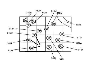
historical
information is available in an accessible format at the planning stage. This
is particularly the
case for industrial plants whose location is limited by natural geographic
features (e.g. mining
and oil and gas wells).
[0006] In the past, geographical and historical data for previous industrial
plants in the oil and
gas sector have been stored in a conventional database. For example, Current
GIS systems in
the marketplace (IFIS Accumap, GeoLogic GeoScout, Canadian Discovery Frac
Database) only
-1-
CA 02916509 2015-12-30
. take publically available information and digitize it. Due to the large
quantity of data
(corresponding to hundreds of thousands of industrial plants, each plant's
performance being
measured by a variety of performance metrics), this information has not been
available in a
sufficiently accessible way because of the processing power required to filter
and process the
data to allow a user to interact with it.
[0007] For example, CNBC published an online news article entitled "Oil firms
are swimming in
data they don't use" (author: Tom DiChristopher; date: 5 March 2015). The
article reported that
a study by McKinsey & Company found that the less than 1 percent of the
information gathered
by the oil industry was being made available to the people in the industry who
make decisions.
The article suggested that, as a result, drillers are almost certainly
operating below peak
performance. The article also highlighted a report by consulting firm Bain &
Co which estimated
that better data analysis could help oil and gas companies boost production by
6 to 8 percent.
The article concludes by stating that a problem is that while oilfield sensors
offer real-time data
on operations, the information is usually used to make immediate, binary
decisions rather than
being stored, filtered and analysed to inform future decision making.
SUMMARY OF THE INVENTION
[0008] In accordance with a first aspect, there is provided a control
apparatus comprising:
memory comprising a database having data on industrial plant performance, each
datum
associated with a location;
a display configured to display a map comprising a selected first geographical
area, the
first geographical area including a first subset of the corresponding
locations in the database;
a processor configured to perform a first statistical analysis on the
industrial plant
performance data associated with the first subset of the corresponding
locations in the
database, and to enable display of results of the first statistical analysis
on the displayed map;
and
a user interface controller configured to allow the user to change the
selected
geographical area displayed from the first geographical area to a second
geographical area, the
second geographical area including a second subset of the corresponding
locations in the
database, the second subset being different from the first subset;
wherein the processor is configured, in response to a change in the
geographical area
being selected, to perform a second statistical analysis on the industrial
plant performance data
-2-
CA 02916509 2015-12-30
associated with locations within the second selected geographical area and to
enable display of
results of the second statistical analysis on the displayed map.
[0009] The first and second statistical analyses may be the same with except
that they are
carried out on different data. That is, the second statistical analysis may be
a rerun of the first
statistical analysis on the second subset of data. The second statistical
analysis may be
performed automatically in response to the change in selected geographical
area.
[0010] The selected geographical area may correspond to the area of a map
displayed on the
display, such that the user interface controller is configured to allow the
user to change the
selected geographical area by changing the area of a map displayed on the
display.
[0011] The user interface controller may be configured to allow the user to
change the selected
geographical area by one or more of scrolling and zooming the area of a map
displayed on the
display. For example, if the area of the map displayed corresponds to the
selected area,
zooming the map may change the displayed area and so change the selected area.
It will be
appreciated that zooming a map may comprise changing the scale of the map
displayed.
[0012] The industrial plant data may correspond to oil drilling industrial
plants.
[0013] The industrial plant data may correspond to mining industrial plants.
[0014] The control apparatus may be configured to: in response to a user
input, display a
portion of the database corresponding to data associated with the selected
locations.
[0015] The control apparatus may be configured to:
in response to a first user input, filter data in the database to generate a
filtered subset of
corresponding locations; and
in response to a second user input, display a map corresponding to the
filtered data.
[0016] The control apparatus may be configured:
to determine, as part of the statistical analysis, one or more of the average
and the
standard deviation parameters corresponding to the displayed subset of
locations; and
to enable display of the determinations by distinguishing locations based on
how the
parameter associated with each location compares with one or more of the
determined average
and the determined standard deviation.
[0017] The control apparatus may be configured: to enable, in response to a
user input,
selection of a geographical area by selecting a portion of a displayed map.
-3-
CA 02916509 2015-12-30
,
,
,
. [0018] The control apparatus may be configured to: in response to a user
input, enable
selection of a geographical area by selecting a characteristic from a list of
characteristics. The
list of characteristics may comprise one or more of: rock formation, altitude,
proximity to water
source, and geographical aspect.
[0019] The control apparatus may be configured to: perform the statistical
analysis on
corresponding locations within the selected geographical area only when the
number of
corresponding locations is below a predetermined threshold.
[0020] The industrial plant locations may be displayed on the map using
industrial plant icons.
The results of the statistical analysis may be displayed on the displayed map
by differentiating
the industrial plant icons.
[0021] The industrial plant icons may be differentiated based on the
statistical analysis using
one or more of: different colours; different shapes; different sizes;
different images; and different
line styles.
[0022] The statistical analysis may comprise ranking the wells corresponding
to locations within
the selected geographical area.
[0023] The control apparatus may form part of for example, a personal digital
assistant (PDA), a
smartphone, a pager, a laptop computer, a tablet computer, a computer, or any
combination of
the aforementioned.
[0024] A user input may comprise a touch gesture (e.g. with a touchpad or
touchscreen). A
touch gesture may comprise one or more of: a multi-touch gesture input (e.g.
pinch-in or pinch-
out gesture); a single-touch gesture; a swiping gesture; and a tap gesture. A
user input may
comprise, for example, clicking and dragging a mouse; pressing a physical
button; and/or
interacting with user-interface elements displayed on the screen (e.g. icons,
zoom level bar,
navigation arrows).
[0025] A user interface controller may be considered to be a component which
allows the user
to control the device. A user interface controller may or may not display or
otherwise provide
information dynamically to the user.
[0026] In accordance with a further aspect, there is provided a method, the
method comprising:
accessing a database having data on industrial plant performance, each datum
associated with a location;
-4-
CA 02916509 2015-12-30
,
,
,
,
displaying a map comprising a selected first geographical area, the first
geographical
area including a first subset of the corresponding locations in the database;
performing a first statistical analysis on the industrial plant performance
data associated
with the first subset of the corresponding locations in the database, and to
enable display of
results of the first statistical analysis on the displayed map;
changing the selected geographical area displayed from the first geographical
area to a
second geographical area, the second geographical area including a second
subset of the
corresponding locations in the database, the second subset being different
from the first subset;
and
performing, in response to a change in the geographical area being selected, a
second
statistical analysis on the industrial plant performance data associated with
locations within the
second selected geographical area and to enable display of results of the
second statistical
analysis on the displayed map.
[0027] In accordance with a further aspect, there is provided a control
apparatus comprising:
memory comprising a database having data relating to multiple parameters
associated
with industrial plant performance, each datum associated with a location;
a display configured to display a map comprising a selected first geographical
area, the
first geographical area including a subset of the corresponding locations in
the database;
a user interface controller configured to allow the user to select a
performance indicator,
the performance indicator corresponding to a relationship between one or more
parameters
from the database;
a processor configured to perform a statistical analysis, based on the
selected
performance indicator, on the industrial plant performance data associated
with the subset of
the corresponding locations in the database, and to enable display of results
of the first
statistical analysis on the displayed map.
[0028] Corresponding computer programs are also disclosed. Computer programs
may be
stored on a non-transitory medium (e.g. a CD, a DVD).
[0029] In accordance with a further aspect, there is provided a computer
program, the computer
program, when run on a computer, being configured to:
enable access of a database having data on industrial plant performance, each
datum
associated with a location;
-5-
CA 02916509 2015-12-30
,
,
=
enable display of a map comprising a selected first geographical area, the
first
geographical area including a first subset of the corresponding locations in
the database;
perform a first statistical analysis on the industrial plant performance data
associated
with the first subset of the corresponding locations in the database, and to
enable display of
results of the first statistical analysis on the displayed map;
enable changing of the selected geographical area displayed from the first
geographical
area to a second geographical area, the second geographical area including a
second subset of
the corresponding locations in the database, the second subset being different
from the first
subset; and
perform, in response to a change in the geographical area being selected, a
second
statistical analysis on the industrial plant performance data associated with
locations within the
second selected geographical area and to enable display of results of the
second statistical
analysis on the displayed map.
[0030] In accordance with a further aspect, there is provided a computer
program, the computer
program, when run on a computer, being configured to:
enable access of a database having data relating to multiple parameters
associated with
industrial plant performance, each datum associated with a location;
enable display of a map comprising a selected first geographical area, the
first
geographical area including a subset of the corresponding locations in the
database;
enable selection of a performance indicator, the performance indicator
corresponding to
a relationship between one or more parameters from the database;
perform a statistical analysis, based on the selected performance indicator,
on the
industrial plant performance data associated with the subset of the
corresponding locations in
the database, and to enable display of results of the first statistical
analysis on the displayed
map.
[0031] These aspects may provide a means to efficiently display, filter, and
analyze historical
and location-dependent industrial plant execution data in a comparative manner
to optimize
engineering decision making processes. The system may permit rapid analysis
and filtration of
complex variables in order to perform statistical analyses for decision making
purposes.
-6-
CA 02916509 2015-12-30
,
,
' BRIEF DESCRIPTION OF THE DRAWINGS
[0032] Various objects, features and advantages of the invention will be
apparent from the
following description of particular embodiments of the invention, as
illustrated in the
accompanying drawings. The drawings are not necessarily to scale, emphasis
instead being
placed upon illustrating the principles of various embodiments of the
invention. Similar reference
numerals indicate similar components.
Figure 1 is a display screen showing a map indicating the location of a number
of
industrial plants in the oil and gas sector.
Figure 2 is a display screen showing a zoomed-in map indicating the location
of a
number of industrial plants in the oil and gas sector.
Figure 3 is a display screen showing a further zoomed-in map indicating the
location of
a number of industrial plants in the oil and gas sector.
Figure 4 is a display screen showing data corresponding to the displayed map.
Figure 5-7 is a display screen showing filtering of the data.
Figure 8 is a display screen showing a map of the filtered data.
Figure 9 is a display screen showing graphical data corresponding to a
selected
industrial plant.
Figure 10 is a display screen showing graphical data corresponding to the map-
displayed industrial plants.
Figure 11 is a display screen showing graphical data corresponding to a
selected
industrial plant.
Figure 12 is a display screen showing graphical data corresponding to the map-
displayed industrial plants.
Figure 13 is a display screen showing graphical data corresponding to the map-
displayed industrial plants.
Figure 14 is a display screen showing the user interacting with a map of the
filtered
data.
Figure 15 is a display screen showing a report generated corresponding to the
user-
interaction of figure 14.
-7-
CA 02916509 2015-12-30
Figure 16 is a display screen showing the results of a scrolling action.
Figure 17 is a display screen showing the results of a zooming action.
Figure 18 is a display screen showing another method of selecting a
geographical area.
Figure 19 is a display screen showing another method of selecting a
geographical area.
Figure 20 is a schematic of the control apparatus.
Figure 21 is a schematic of the method carried out by the control apparatus.
DETAILED DESCRIPTION OF THE INVENTION
[0033] With reference to the figures, a control apparatus is described. In
this case, the control
apparatus comprises: memory comprising a database having data on industrial
plant
performance, each datum associated with a location; a display configured to
display a map
comprising a selected first geographical area, the first geographical area
including a first subset
of the corresponding locations in the database; a processor configured to
perform a first
statistical analysis on the industrial plant performance data associated with
first subset of the
corresponding locations in the database, and to enable display of results of
the first statistical
analysis on the displayed map; a user interface controller configured to allow
the user to change
the selected geographical area displayed from the first geographical area to a
second
geographical area, the second geographical area including a second subset of
the
corresponding locations in the database, the second subset being different
from the first subset;
wherein the processor is configured, in response to a change in the selected
geographical area
being displayed, to perform a second statistical analysis on the industrial
plant performance
data associated with locations within the second selected geographical area
and to enable
display of results of the second statistical analysis on the displayed map.
[0034] Plant performance data may comprise one or more of: building progress
(i.e. indicating
how close the industrial plant is to completion); output (e.g. oil production
for an oil well); down-
time data (e.g. how much time is the plant not operational).
[0035] Specific to Upstream oil and gas development, the technology is
applicable to drilling,
completions, facility and pipeline construction, and production operations. It
is also applicable to
other industries where comparative data analysis techniques can be automated.
Displaying the
information in an aggregated and comparative manner is particularly useful for
operational
information in which geographic variation can exist in data (e.g. for mining,
the rock types in a
particular location may affect the efficiency of the drilling of the mine
borehole).
-8-
CA 02916509 2015-12-30
[0036] Figure 1 depicts the display of a first embodiment. In this case, the
display 101 is a touch
screen. That is, in this case, the screen is both the display and the user
interface controller. It
will be appreciated that in other embodiments, the display and the user
interface controller may
be separate (e.g. a screen and mouse).
[0037] The embodiment of figure 1 also comprises a memory (not shown) which
comprises a
database having data on industrial plant performance, each datum associated
with a location. In
this case, the industrial plants are in the oil and gas sector and correspond
to, for example,
existing oil wells (pre- and post-completion) and oil refineries.
[0038] In figure 1, the screen is showing a zoomed-out map 102 (corresponding
to Canada).
Because of the large number of industrial plants within the displayed
location, the control
apparatus is configured to group the industrial plant locations in clusters,
and indicate the
location of the clusters using user interface icons 111. In this case, the
cluster user interface
icons comprise a number indicating the number of industrial plant locations
stored in the
database in that cluster. It will be appreciated that the cluster user
interface icons may be
selectable by interacting with the user interface controller (e.g. by tapping
or double-clicking).
That is, in response to the cluster user interface icon being selected, the
apparatus may be
configured to show a map corresponding to the industrial plants in the
cluster.
[0039] Figure 2 shows the display when the user has navigated to a smaller
area using a
combination of zooming and/or scrolling the map. In this case, the map is
zoomed using a multi-
touch gesture input (e.g. pinch-in or pinch-out gesture); and the map is
scrolled using swiping
gestures. It will be appreciated that, in other embodiments, the controller
may be configured to
enable zooming and/or scrolling in different ways ¨ for example, clicking and
dragging a mouse;
and/or interacting with user-interface elements displayed on the screen (e.g.
icons, zoom level
bar, navigation arrows). In this case, the selected geographical area
corresponds to the area of
a map displayed on the display, such that the user interface controller is
configured to allow the
user to change the selected geographical area by changing the area of a map
displayed on the
display.
[0040] Although the geographical area of the displayed map in figure 2 is
smaller (because is
has been zoomed in), there are still too many industrial plants with locations
within the map to
allow each industrial plant to be identified individually. In this case, the
cluster user interface
icons (e.g. 211a, 211b) are configured to correspond to government designated
regions (e.g.
townships). As with the map of figure 1, the displayed maps of this embodiment
comprise
physical and/or non-physical features to enable the user to understand the
portion of the map
-9-
CA 02916509 2015-12-30
,
,
which is being displayed. For example, the features may comprise one or more
of: natural
physical features (e.g. lakes 202b, rivers 202a, coastline, mountains, contour
lines); settlement
locations (e.g. towns, villages, cities); man-made structures (e.g. roads,
train tracks); and non-
physical features (e.g. boundaries between states, provinces, townships,
counties etc.).
[0041] In this case, the user selects the cluster user interface icon 211a
corresponding to a
particular township and, in response, the control apparatus zooms and/or
scrolls the map to that
township. The results are shown in figure 3. Because there are a sufficiently
small number of
industrial plant locations within the selected township, the control apparatus
identifies the
location of the each of the corresponding industrial plants individually using
an industrial plant
icon 312a-n. In this case, there are 14 individually identified plants. In
other embodiments, the
screen size and/or icon size may allow up to 500 individually identified
plants.
[0042] The industrial plant icons 312a-n indicate the location of the
corresponding plant either
by being over the corresponding location (e.g. 312a) on the map or, if for
example, the locations
of multiple plants are too close together (e.g. 312k-m), by a line from the
icon to the
corresponding location on the map. In this case, the industrial plant icons
312a-n also indicate
the type of the plant using an image within the icon. In this case, all of the
industrial plants are
oil rigs. If the map were configured to show, for example, oil refineries the
corresponding icon
may have an image denoting the location as the location of an oil refinery. It
will be appreciated
that the industrial plant icons may indicate other information such as: plant
ownership or
operator; plant stage (e.g. projected plant; pre-completion oil rig; post-
completion oil rig).
[0043] In this embodiment, when the number of locations within the selected
area is sufficiently
small to allow them to be displayed individually, the processor of the control
apparatus is
configured to perform a first statistical analysis on the industrial plant
performance data
associated with first subset of the corresponding locations in the database,
and to enable
display of results of the first statistical analysis on the displayed map.
That is, in this case, the
selected area for statistical analysis corresponds to the displayed area of
the map when the
area of the map is sufficiently below a threshold area (the threshold in this
case relating to how
many individual plants can be displayed). By restricting the selection of an
area for statistical
analysis in this way, the processor does not attempt to perform the
statistical analysis on a large
area with a corresponding large number of data points. This may speed up
navigation when
large areas are being viewed.
[0044] In this case, the industrial plant icons 312a-n also indicate the
results of a statistical
analysis carried out on the displayed industrial plants shown on the map. In
this case, the
-10-
CA 02916509 2015-12-30
,
, .
controller is configured to perform a statistical analysis on plants within
the map (which
corresponds to the selected geographical area in this case) and display the
results. In this case,
the statistical analysis comprises calculating the average (the mean in this
case, but other
averages may be used in other embodiments) and standard deviation of the
drilling rate of the
oil-rigs and determining which of the displayed industrial plants have a
drilling rate greater than
one standard deviation over average; which of the displayed oil-rig locations
have a drilling rate
within one standard deviation of average; and which of the displayed oil-rig
locations have a
drilling rate lower than one standard deviation below average. It will be
appreciated that the
statistical analysis may be performed on other parameters or combinations of
parameters.
These parameters may be key performance indicators (KPIs) associated with a
particular field
(e.g. drilling rate in a drilling context).
[0045] Other embodiments may allow user-selectable aggregation and analysis of
data. For
example, other embodiments may allow the user to customize the "binning" of
the data and the
type of statistical analysis (T-score, S-score, etc.). Other embodiments, may
allow the user to
define user-defined statistical comparators (Key Performance Indicators ¨
KPI). In addition to
the predetermined KPIs (meters/day; $/meter; Tonnes*meter/stages, IP30/$;
IP30/tonnes,
where IP (Initial Production Rate) is the initial flow rate of the well,
typically 24-72 hours, and
IP30 is the average Initial production for the 1st 30 Days; and frac
intensity).
[0046] Other embodiments may be configured to allow statistical analysis of
historical data in
relation to engineering and operational input parameters.
[0047] In this case, the industrial plant icons 312g,i,j corresponding to
locations having a drilling
rate greater than one standard deviation over average are displayed with a
double-line outline.
The industrial plant icons 312e,f,h,k-n corresponding to locations having a
drilling rate within
one standard deviation of average are displayed with a single-line outline.
The industrial plant
icons 312a-d corresponding to locations having a drilling rate lower than one
standard deviation
below average are displayed with a dotted outline. It will be appreciated that
other graphical
indications may be used to indicate the results of the statistical analysis.
For example, the size,
colour and/or shape of the industrial plant icons may be used to indicate the
results of the
statistical analysis. In this way, the outliers can be quickly identified and
each plant's
performance ranked.
[0048] From the map of figure 3, it is apparent that there is a grouping of
low-performance wells
in the top left 312a-d, whereas the high-performance wells 312g,h,i are
towards the bottom
right. This may indicate that the geological conditions are more favorable in
locations
-11-
CA 02916509 2015-12-30
. 41
. ,
corresponding to the bottom right of the map. It will be appreciated that this
information is more
readily extracted from a map view than from a database view of the database.
This information
may be used in determinations of future oil-rig locations and for
identification of optimum
executional practices.
[0049] In this case, the user can also view the corresponding database
portion. Figure 4 shows
the database view corresponding to the map view of figure 3. That is, the
database view shows
a scrollable subset of the database corresponding to the locations within the
corresponding
displayed map. In this way, the user can control which subset of the database
is shown by
controlling the extent and position of the map. As with the map, the tuples or
rows of the
database are visually distinguished based on the statistical analysis. In this
case, the industrial
plant data rows 422i corresponding to locations having a drilling rate greater
than one standard
deviation over average are displayed with a double-line underline. The
industrial plant data rows
422f,h,k-m corresponding to locations having a drilling rate within one
standard deviation of
average are displayed with a single-line underline. The industrial plant data
rows 422d
corresponding to locations having a drilling rate lower than one standard
deviation below
average are displayed with a dotted underline. It will be appreciated that
other graphical
indications may be used to indicate the results of the statistical analysis.
For example, the size,
colour (e.g. red for below average; yellow for average; and green for above
average) and/or font
may be used to indicate the results of the statistical analysis.
[0050] Figures 5 and 6 show how the user can interact with the database subset
corresponding
to the mapped area to filter out undesired data. In this case, the user is
particularly interested in
oil-rigs which have been drilled in a particular rock formation (Cardium, in
this case); and oil-rigs
with a particular well-structures (horizontal or directional wells). That is,
the user may be
planning to start a new well in a Cardium rock formation and may know from
surveys that a
vertical well may not be sufficient to access the oil. In this case, the user
can select the column
headers which show a corresponding list 521, 621 of the available entries in
that list. By
selecting some of the entries (indicated by a tick) and not selecting other
available entries
(indicated by a circle), the user can filter the rows or tuples in the
database subset. Figure 5
show how the user has selected cardium formations and figure 6 shows how the
user has
selected Directional and Horizontal wells.
[0051] Figure 7 shows the results of the filtering. In this case, the
controlling apparatus is
configured to re-run (e.g. automatically) the statistical analysis when the
filtering is complete or
at each filtering stage. It will be appreciated that the removal or addition
of certain industrial
-12-
CA 02916509 2015-12-30
=
plant data may affect the average and standard deviation of the remaining
filtered industrial
plant data. For example, although the 'Shale v2' well was within 1 standard
deviation of the
average before filtering (indicated by a single underline in figure 4), after
filtering, the 'Shale v2'
well is now more than one standard deviation above average (indicated by a
double underline in
figure 7). It will be appreciated that, in some embodiments, the filtering may
be performed in the
map view (e.g. using a list and/or filtering wells to have a particular
parameter, such as rock
formation, the same as an individual selected plant).
[0052] The user then reverts to the map view, as shown in figure 8. As shown
in figure 8, the
industrial plant icons 812a-d,f,h-i have been updated to reflect the filtering
of the plant data (few
industrial plants are indicated on the map) and the new statistical analysis
on the filtered data.
[0053] This embodiment is configured to allow the user to move back and forth
between the
database view, a report view (in which data from the database is collated and
displayed in the
form of a report) and the map view. In this case, the user wishes to see data
corresponding to
the 'Shale v2' oil-rig which is indicated by the industrial plant icon 812h on
the bottom right of
the map view. To view the desired report, the user interacts with the
industrial plant icon 812h to
select the 'Shale v2' industrial plant icon and selects from a number of data
display options. In
this case, the user wishes to see how the actual cost of the plant compares to
the estimated
cost, so the user selects the appropriate data display option. The resulting
data report display is
shown in figure 9.
[0054] In this case, the user can also compare the estimated and actual costs
of the other
industrial plants in the map view (as shown in figure 8). This is shown in
figure 10. In this case,
the industrial plants are displayed in order of drilling rate (which is the
parameter used in the
statistical analysis, in this case).
[0055] It will be appreciated that the control apparatus may be configured to
allow the user to
select a different statistical analysis and to display the results of the
selected statistical analysis
on the display (e.g. in the map view, in the database view and/or in a
graphical format). For
example, the control apparatus may be configured, in this case, to allow the
user to elect to
perform a statistical analysis on the estimated and actual costs of the
displayed industrial plants.
For example, the control apparatus may be configured by the user to calculate
the average and
standard deviation of the actual cost of the industrial plant. This would
allow the user to see
from the map view that, although the 'Shale v2' oil rig has an above-average
drilling rate, the
actual cost of the 'Shale v2' oil rig is also higher than average. In other
embodiments, statistical
analysis may be performed on a combination of parameters. For example, the
statistical
-13-
CA 02916509 2015-12-30
,
,
,
analysis may compare the actual cost divided by the drilling rate. Parameters
stored directly in
the database or derived parameters (calculated from raw data in the database)
may include, but
are not limited to: drilling speed; depth of drilling (for a well or
particular drill bit); cost per meter
drilled; average cement returns to surface versus % excess cement pumped.
[0056] The controller may be configured to allow the user to select a
performance indicator (e.g.
corresponding to a parameter stored directly in the database or a derived
parameter) for
statistical analysis. That is, a user interface controller configured to allow
the user to select a
performance indicator, the performance indicator corresponding to a
relationship between one
or more parameters from the database; and the processor may be configured to
perform a
statistical analysis based on the selected performance indicator on the
industrial plant
performance data associated with the subset of the corresponding locations in
the database,
and to enable display of results of the first statistical analysis on the
displayed map.
[0057] The control apparatus may be configured to visually identify the best
or worst industrial
plant on the display based on a particular parameter including, but not
limited to (e.g.: fastest or
longest drill bit run, most efficient drilling performance (mid), lowest cost
per meter drilled,
average cement returns to surface versus % excess cement pumped).
[0058] Figures 11-13 show a different reporting display. In figure 11, the
various drills used to
create the 'Shale v2' well are shown ordered by depth drilled. The vertical
bars indicate the
depth range at which each drill was used. The circles indicate the drilling
rate for each drill. In
this case, the user navigated to the display shown in figure 11 by selecting a
particular industrial
plan icon and selecting a drilling report from a revealed list.
[0059] From figure 11, the user can select to see the corresponding data for
the other plants in
the selected area. Figure 12 shows a comparison of all the drills used to
drill all of the displayed
industrial plants. As in figure 12, the wells are ordered by the average
drilling rate.
[0060] Figure 13 shows an alternative representation of the data in figure 12.
In this case, the
drilling depth for each rig is shown with time from an initial drilling-start
time (e.g. corresponding
to well spudding). In this case, the control apparatus is configured to
compare the various
phases of the subset of wells in the selected geographical area and determine
which of the drills
used in each phase was the most effective (i.e. had the highest drilling rate
or productivity).
From this information, the control apparatus is configured to calculate a
theoretically optimum
drilling schedule, which takes into account the drills with the greatest
drilling rate and the
-14-
CA 02916509 2015-12-30
,
,
downtime necessary to change drills. That is, embodiments may be configured to
combine
information from the plants within the selected area to present statistical
best-efforts results.
[0061] In figure 14, the user has returned to the map view and is in the
process of selecting a
new report to view. In this case, the user has selected a particular
industrial plant (the 'NFL exp'
oil rig industrial plant icon 1412i in this case). Selecting a particular
industrial plant, in this case,
displays a brief summary 1431 of data associated with this industrial plant
including when
drilling was commenced (spud date); average drilling rate; geological
formation; and drill type.
The summary also includes a 'Reports' user interface element 1432 which, when
selected,
allows the user to select which report 1433a-c to view. In this case, the user
selects to view the
'mud report' 1433c. The mud report (as shown in figure 15) is derived by
examining the physical
properties of the drilling medium (most commonly called drilling mud). In this
case, the density
of the material for a given depth is displayed. This information is important
as the drilling fluid
density required to control reservoir pressure during drilling operations is
indicative of the
reservoir pressure and corresponding potential productivity of the wellbore.
[0062] After viewing the mud report, the user navigates back to the map view
(as shown in
figure 8). The user then wishes to view a different geographic area and so
scrolls the map. In
this case, this includes new industrial plant locations 16120 in the displayed
map. In response to
the selected geographical area being changed by being scrolled, the processor
is configured to
perform a new statistical analysis on the industrial plant performance data
associated with
locations 1612a-d,i,o within the second selected geographical area and to
enable display of
results of the second statistical analysis on the displayed map. As before,
the results of the
statistical analysis are shown by displaying a border on each industrial plant
icon which is
dependent on how the parameter for that industrial plant compares with the
results of the
statistical analysis.
[0063] The user then wishes to view a larger geographical area and so zooms
out using a
pinch-out multi-touch gesture. In this case, the zooming-out results in
additional industrial plants
1712p,q being included in the selected displayed geographical area. In
response to the
geographical area being changed by being zoomed, the processor is configured
to perform a
new statistical analysis on the industrial plant performance data associated
with locations within
the second selected geographical area and to enable display of results of the
second statistical
analysis on the displayed map. As before, the results of the statistical
analysis are shown by
displaying a border on each industrial plant icon which is dependent on how
the parameter for
that industrial plant compares with the results of the statistical analysis.
For example, based on
-15-
CA 02916509 2015-12-30
the new statistical analysis, the industrial plant 1612o which was within one
standard deviation
of the average based on the industrial plants within the geographical area of
figure 16 is not
more than one standard deviation below average as indicated by the
corresponding plant icon
17120 in figure 17.
[0064] It will be appreciated that there maybe other ways of selecting a
geographical area
within a display. In the case shown in figure 18, the control apparatus is
configured to: in
response to a user input, enable selection of a geographical area by selecting
a portion of a
displayed map. This is shown in figure 18 where the user has selected a
geographical area by
drawing a line around a portion of the displayed map. In response to this new
selection, the
control apparatus is configured to perform a new statistical analysis on the
industrial plant
performance data associated with locations within the second selected
geographical area and to
enable display of results of the second statistical analysis on the displayed
map. In this case,
one of the industrial plants shown in figure 17 (indicated by plant icon
1812b) as being below
average is now within one standard deviation of being average. Those plants
which are not part
of the statistical analysis are, in this case, indicated by the corresponding
plant icons 1812i,o,p
not having a border.
[0065] In the case shown in figure 19, the control apparatus is configured to:
in response to a
user input, enable selection of a geographical area by selecting a
characteristic from a list of
characteristics. This is shown in figure 19 where the user has selected a
geographical area by
defining that the industrial plants must be within 50km of a water source
(boundary shown by
dashed line 1951) and to be below 1000m above sea level (boundary shown by
dash-dot line
1952). In response to this new selection, the control apparatus is configured
to perform a new
statistical analysis on the industrial plant performance data associated with
locations within the
second selected geographical area and to enable display of results of the
second statistical
analysis on the displayed map.
[0066] It will be appreciated that the results of the statistical analysis may
be displayed in other
ways. For example, the area of the displayed geographical area may be divided
up into regions
based on the closest industrial plant location (e.g. using a Voronoi
tessellation), and each of the
regions (e.g. Voronoi cells) may be coloured (or otherwise differentiated)
based how the
parameters of the closest industrial plant compares with the statistical
analysis. In another
embodiment, geographic positions between industrial plant locations may be
associated with a
statistical value based on the statistical results of neighbouring industrial
plants (e.g. a weighted
average of the three closest industrial plants where the influence of each
neighbouring industrial
-16-
CA 02916509 2015-12-30
plant is scaled based on the distance to the geographic position). This may
allow potential
industrial plant sites to be assessed more easily.
[0067] It will be appreciated that the statistical analysis method may be set
by the user. For
example, the user may elect to use the median value as the average rather than
the mean.
[0068] Figure 20 is a schematic of the control apparatus. In this case, the
control apparatus
2000 comprises a memory 2091 storing a database 2092; a processor 2093; and a
display
2001.
[0069] Memory 2091 may comprise one or more of, for example: a CD, a DVD,
flash memory, a
floppy disk, a hard disk, volatile memory, non-volatile memory or Random
Access Memory.
[0070] A processor 2093 may comprise one or more of, for example: a central
processing unit
(CPU); a microprocessor; a central processing unit contained on a single
integrated circuit (IC);
an application-specific integrated circuit (ASIC); an application-specific
instruction set processor
(ASIP); a graphics processing unit (GPU); a network processor, a
microprocessor specifically
targeted at the networking application domain; a multi-core processor.
[0071] A display may comprise one or more of, for example: a cathode ray tube
or liquid crystal
display (LCD); a computer screen; a smartphone screen; a tablet computer
screen; a
touchscreen; a projection screen; and a television screen.
[0072] A user interface controller may comprise one or more of, for example, a
touchscreen, a
keyboard, a mouse, a joystick, and a touchpad.
[0073] The controller may be configured to interact with remote databases to
populate the local
database. The remote databases may be accessible via the internet 2094. It
will be appreciated
that the memory, processor and display may not be part of a single computer.
That is, the
various components may be stored across several devices. For example, the
database may be
stored on a cloud computer. That is, the end user may have a client terminal
which is configured
to access a remote server which performs the calculations. Some embodiments
may be
configured to mine published data (e.g. published on the internet). For
example, the controller
may be configured to extract key data points from electronic media (e.g.: XLS,
PDF, XML, CSV,
PPT, etc.) sources without user intervention store the extracted data in the
database.
[0074] Figure 21 is a flow diagram showing a method of processing data. That
is, first a
geographical area is selected. This geographical area is then displayed as a
map view. The
selected geographical area, in this case, includes a first subset of the
corresponding locations in
-17-
CA 02916509 2015-12-30
the database, each of the corresponding locations being associated with an
industrial plant and
other data relating to that industrial plant.
[0075] A statistical analysis is then performed on industrial plant
performance data
corresponding to the selected data. The results of the statistical analysis
are then displayed on
the displayed geographical area.
[0076] The method comprises, in response to the selected geographical area
being changed,
displaying a new map comprising the newly selected geographical area and
performing the
statistical analysis of the plants within the newly selected geographical area
for display on the
map.
[0077] Although the present invention has been described and illustrated with
respect to
preferred embodiments and preferred uses thereof, it is not to be so limited
since modifications
and changes can be made therein which are within the full, intended scope of
the invention as
understood by those skilled in the art.
-18-