Note: Descriptions are shown in the official language in which they were submitted.
ESTIMATING AND PREDICTING WELLBORE TORTUOSITY
CROSS-REFERENCE TO RELATED APPLICATIONS
[0001] None.
BACKGROUND
[0002] A number of issues may arise when drilling a well into a hydrocarbon
bearing
formation. The issues that arise may be a result of the formation itself, or
the quality
of the wellpath. In some cases, there may be a correlation between the
undulations
present in the wellpath and drilling issues.
SUMMARY
[0002a] In accordance with a general aspect of the present application, there
is
provided a method comprising receiving, by a computer system, an indication of
rotational drilling time and slide drilling time for a wellpath, calculating a
value
indicative of tortuosity for the wellpath based on the indication of
rotational drilling
time and slide drilling time for the wellpath, determining, by the computer
system,
that the wellpath exceeds a tortuosity threshold, the determining based on the
value
indicative of tortuosity, and changing a drilling parameter regarding the
wellpath
responsive to determining that the wellpath exceeds the tortuosity threshold.
[0002b] In accordance with a general aspect of the present application, there
is also
provided a system comprising a processor, a memory coupled to the processor,
the
memory storing a program that, when executed by the processor, causes the
processor to receive an indication of rotational drilling time and slide
drilling time for
a wellpath, calculate a value indicative of tortuosity for the wellpath based
on the
indication of rotational drilling time and slide drilling time for the
wellpath, determine
that the wellpath exceeds a tortuosity threshold, the determining based on the
value
indicative of tortuosity, and change a drilling parameter regarding the
wellpath
responsive to determining that the wellpath exceeds the tortuosity threshold.
[0002c] In accordance with a general aspect of the present application, there
is also
provided a non-transitory computer-readable medium storing a program that,
when
executed by a processor, causes the processor to receive an indication of
rotational
drilling time and slide drilling time for a wellpath, calculate a value
indicative of
tortuosity for the wellpath based on the indication of rotational drilling
time and slide
drilling time for the wellpath, determine that the wellpath exceeds a
tortuosity
threshold, the determining based on the value indicative of tortuosity, and
change a
CA 2919506 2017-06-13
CAN_DMS. \106600678\2
la
drilling parameter regarding the wellpath responsive to determining that the
wellpath
exceeds the tortuosity threshold.
BRIEF DESCRIPTION OF THE DRAWINGS
[0003] For a detailed description of exemplary embodiments, reference will now
be
made to the accompanying drawings in which:
[0004] Figure 1 is a partial, cross-sectional elevation view that shows an
offshore
drilling system in accordance with at least some embodiments;
[0005] Figure 2 is a partial, cross-sectional elevation view that shows a land-
based
drilling system in accordance with at least some embodiments;
[0006] Figure 3A is an elevation cutaway view of a bent housing mud motor in a
wellbore in accordance with at least some embodiments;
[0007] Figure 3B is a elevation cutaway view of a bent housing mud motor in a
wellbore in accordance with at least some embodiments;
[0008] Figure 4 is a perspective cutaway view which shows a portion of a
hydrocarbon bearing formation in accordance with at least some embodiments;
[0009] Figure 5 is an elevation view which shows a planned wellpath in
accordance
with at least some embodiments;
[0010] Figure 6 is an example slide sheet in accordance with at least some
embodiments;
[0011] Figure 7 is an elevation view which shows a partially drilled wellbore
in
accordance with at least some embodiments;
[0012] Figure 8 is an elevation view which shows a partially drilled wellbore
in
accordance with at least some embodiments;
CA 2919506 2017-06-13
CAN_DMS:110660067812
CA 02919506 2016-01-26
WO 2015/030799
PCT/US2013/057580
2
[0013] Figure 9 is an elevation view which shows a partially drilled wellbore
in
accordance with at least some embodiments;
[0014] Figure 10 is a block diagram that shows a computer system in
accordance with at least some embodiments; and
[0015] Figure 11 is a block diagram that shows a method in accordance with at
least one embodiment.
NOTATION AND NOMENCLATURE
[0016] Certain terms are used throughout the following description and claims
to
refer to particular system components. As one skilled in the art will
appreciate,
different companies may refer to a component by different names. This
document does not intend to distinguish between components that differ in name
but not in function. In the following discussion, and in the claims, the terms
"including" and "comprising" are used in an open-ended fashion, and thus
should
be interpreted to mean "including, but not limited to... ." Also, the term
"couple" or
"couples" is intended to mean either an indirect or direct connection. Thus,
if a
first device couples to a second device, that connection may be through a
direct
connection or through an indirect connection via other devices and
connections.
[0017] "Wel!bore" shall mean a hole drilled into the Earth's crust used
directly or
indirectly for the exploration or extraction of natural resources, such as
oil, natural
gas, or water.
[0018] "Wel!path" shall mean a planned or actual path of a wellbore or portion
of a wellbore.
[0019] "Rotational drilling" shall mean planned or actual drilling where at
least
some of the rotation of the drill bit is supplied by rotation of the
drillstring from the
surface.
[0020] "Slide drilling" shall mean planned or actual drilling where the drill
bit is
rotated down hole while the drillstring at the surface is held against
rotation.
[0021] "Surface" shall mean any point residing 10 feet below ground level and
extending upward in relation to the local force of gravity.
[0022] "Offset well" shall mean a well drilled in the past or being drilled
concurrently with a planned or actual wellbore of interest.
CA 02919506 2016-01-26
WO 2015/030799
PCT/US2013/057580
3
[0023] "Dogleg severity" shall mean a value related to the overall curvature
of a
wellpath between survey points.
[0024] "Tortuosity threshold" shall mean a value indicative of an expected or
actual tortuosity above which adjustments may be made to the drilling plan.
DETAILED DESCRIPTION
[0025] The following discussion is directed to various embodiments of the
invention. Although one or more of these embodiments may be preferred, the
embodiments disclosed should not be interpreted, or otherwise used, as
limiting
the scope of the disclosure, including the claims. In addition, one skilled in
the art
will understand that the following description has broad application, and the
discussion of any embodiment is meant only to be exemplary of that embodiment,
and not intended to intimate that the scope of the disclosure, including the
claims,
is limited to that embodiment.
[0026] The various embodiments are directed to methods and systems of
calculating a tortuosity value for a wellpath based on a relationship between
rotational drilling time and slide drilling time. In an example embodiment,
data
from a slide sheet prepared for a planned wellpath is input into a model which
calculates a tortuosity value for a planned wellpath based on, at least in
part, the
relationship between planned rotational drilling and slide drilling time. If
the
tortuosity value calculated by the model is above a predetermined tortuosity
threshold, adjustments may be made to the drilling plan or to other drilling
parameters. The specification first turns to a high level overview.
[0027] Figure 1 shows an example subsea drilling operation. In particular,
Figure 1 shows a bottomhole assembly 100 for a subsea drilling operation,
where
the bottomhole assembly 100 illustratively comprises a drill bit 102 on the
distal
end of the drillstring 104. Various logging-while-drilling (LWD) and measuring-
while-drilling (MWD) tools may also be coupled within the bottomhole assembly
100. In the example system, a logging tool 106 may be coupled just above the
drill bit, where the logging tool may read data associated with the wellbore
(e.g.,
inclination, and direction). In some cases, the bottomhole assembly 100 may
comprise a mud motor 112. The mud motor 112 may derive energy from drilling
fluid flowing within the drillstring 104 and, from the energy extracted, the
mud
CA 02919506 2016-01-26
WO 2015/030799
PCT/US2013/057580
4
motor 112 may rotate the drill bit 102 (and if present, the logging tool 106)
separate and apart from rotation imparted to the drillstring by surface
equipment. The mud motor may also comprise a bent housing sub assembly (not
specifically shown in Figure 1, but which will be discussed later) to aid in
altering
the trajectory of the wellbore. Additional logging tools may reside above the
mud
motor 112 in the drillstring, such as illustrative logging tool 114.
[0028] The bottomhole assembly 100 is lowered from a drilling platform 116 by
way of the drillstring 104. The drillstring 104 extends through a riser 118
and a
well head 120. Drilling equipment supported within and around derrick 123
(illustrative drilling equipment discussed in greater detail with respected to
Figure 2) may rotate the drillstring 104, and the rotational motion of the
drillstring 104 and/or the rotational motion created by the mud motor 112
causes
the bit 102 to form the wellbore 108 through the formation material 122. The
volume defined between the drillstring 104 and the wellbore 108 is referred to
as
the annulus 125. The wellbore 108 penetrates subterranean zones or reservoirs,
such as reservoir 110, believed to contain hydrocarbons in a commercially
viable
quantity.
[0029] In accordance with at least some embodiments, the bottomhole
assembly 100 may further comprise a communication subsystem. In particular,
illustrative bottomhole assembly 100 comprises
a telemetry
module 124. Telemetry module 124 may communicatively couple to the various
logging tools 106 and 114 and receive logging data measured and/or recorded by
the logging tools 106 and 114. The telemetry module 124 may communicate
logging data to the surface using any suitable communication channel (e.g.,
pressure pulses within the drilling fluid flowing in the drillstring 104,
acoustic
telemetry through the pipes of the drillstring 104, electromagnetic telemetry,
optical fibers embedded in the drillstring 104, or combinations), and likewise
the
telemetry module 124 may receive information from the surface over one or more
of the communication channels.
[0030] Figure 2 shows an example land-based drilling operation. In particular,
Figure 2 shows a drilling platform 200 equipped with a derrick 202 that
supports a
hoist 204. The hoist 204 suspends a top drive 208, the hoist 204 and top drive
CA 02919506 2016-01-26
WO 2015/030799
PCT/US2013/057580
rotate and lower the drillstring 103 through the wellhead 210. Drilling fluid
is
pumped by mud pump 214 through flow line 216, stand pipe 218, goose
neck 220, top drive 208, and down through the drillstring 104 at high
pressures
and volumes to emerge through nozzles or jets in the drill bit 102. The
drilling
fluid then travels back up the wellbore via the annulus 125, through a blowout
preventer (not specifically shown), and into a mud pit 224 on the surface. On
the
surface, the drilling fluid is cleaned and then circulated again by mud
pump 214. The drilling fluid is used to cool the drill bit 102, to carry
cuttings from
the base of the wellbore to the surface, and to balance the hydrostatic
pressure in
the rock formations.
[0031] In the illustrative case of the telemetry module 124 encoding pressure
pulses that propagate to the surface, one or more transducers, such as
transducers 232, 234, and/or 236, convert the pressure signal into electrical
signals for a signal digitizer 238 (e.g., an analog-to-digital converter).
While three
transducers 232, 234, and/or 236 are illustrated, more transducers or fewer
transducers may be used in particular situations. The digitizer 238 supplies a
digital form of the pressure signals to a surface computer 240 or some other
form
of a data processing device. Surface computer 240 operates in accordance with
software (which may be stored on a computer-readable storage medium) to
monitor and control the drilling processing, including instructions to process
and
decode the received signals related to telemetry from downhole. The surface
computer 240 is communicatively coupled to many devices in and around the
drilling site, and such communicated couplings are not shown as to not to
unduly
complicate the discussion.
[0032] In some cases, data gathered and/or generated in and around the drill
site (e.g., estimated or actual tortuosity data), as well as the logging data
sent by
the telemetry module 124, may be displayed on a display device 241. In yet
still
other example embodiments, the surface computer 240 may forward the data to
another computer system, such as a computer system 242 at the operations
center of the oilfield services provider, the operations center remote from
the drill
site. The communication of data between computer system 240 and computer
CA 02919506 2016-01-26
WO 2015/030799
PCT/US2013/057580
6
system 242 may take any suitable form, such as over the Internet, by way of a
local or wide area network, or as illustrated over a satellite 244 link.
[0033] ¨ Overview of Slide Drilling and Rotational Drilling
[0034] The trajectory of a wellpath may include straight vertical sections,
curved
sections, and straight non-vertical sections in order to reach a specified
target.
The driller will alternate between periods of slide drilling and rotational
drilling in
order to reach the specified target along the wellpath. Slide drilling is used
to
build, correct, or change the angle of drilling in the wellbore. On the other
hand,
rotational drilling is used to maintain the trajectory of the wellbore at the
current
azimuth and inclination. In other words, when the desired direction of the
wellbore is attained, rotational drilling is used to continue drilling
straight ahead,
whereas slide drilling is used to create a curved path. The slide drilling
mode and
rotation drilling mode are described in more detail with respect to Figures 3A
and
3B.
[0035] Figures 3A and 3B show a steerable mud motor housing 300 comprising
a bent sub assembly 302, a motor 304, and a drill bit 306. It should be noted
that
the angle of the bend shown in the bent sub assembly 302 has been exaggerated
for clarity, and that in practice the bend may be on the order of one or two
degrees from the axis of the mud motor housing.
[0036] As discussed above, the bent sub assembly is used in one of two
modes: a rotational drilling mode and a slide drilling mode. Figure 3A shows
the
wellbore 312 and mud motor housing 300 during a period of slide drilling. The
slide drilling mode is used to create a curved path. During slide drilling,
drilling
fluid flowing through the drillstring causes the motor 304 to rotate the drill
bit 306
while the drillstring at the surface is held against rotation. Because the
drillstring
is not rotating from the surface during slide drilling, the angle and
direction of the
bent sub assembly 302 determines the direction and curvature of drilling. The
angle and direction of the bent sub assembly 302 can be determined from the
surface by obtaining information about the orientation of the bent sub
assembly
302 through measuring instruments downhole (such as MWD or LWD tools
located within the BHA 308). By changing the orientation of the drillstring,
and
CA 02919506 2016-01-26
WO 2015/030799
PCT/US2013/057580
7
thus changing the direction the bent sub assembly may be directed, the driller
can
thus change the direction of the drilling.
[0037] Figure 3B shows the wellbore 312 and mud motor housing 300 during
rotational drilling. During rotational drilling, the wellbore is drilled to
maintain the
current trajectory (e.g., the current azimuth and inclination), as opposed to
creating a curved path. In particular, the entire drillstring is rotated from
the
surface, including motor 304, and drill bit 306. During rotational drilling,
because
the distal end of the drillstring is bent at an angle from the axis of the
remainder of
the drillstring, the distal end of the drillstring may "sweep" around the
borehore
within the area indicated by dashed lines 314.
[0038] Using a combination of slide drilling and rotational drilling, the
driller
attempts to drill the wellbore along the planned wellpath trajectory. Despite
attempting to follow the planned wellpath trajectory, it is possible that the
actual
drilled path may be off course or may have some unexpected tortuosity as
drilling
gets underway. Although some tortuosity may be expected, excessive tortuosity
may cause drilling issues.
[0039] ¨ PLANNING A WELLPATH
[0040] Figure 4 shows a perspective cutaway view of a portion of the earth's
crust. In particular, Figure 4 shows the surface 400 of the earth, and below
the
surface 400 is a portion of a hydrocarbon bearing formation 402. The
overburden
layer between the surface 400 and the hydrocarbon bearing formation 402 is not
shown so as to not unduly complicate the figure. Figure 4 also shows a planned
wellpath 404 extending to and through the hydrocarbon bearing formation, and
the planned wellpath having an estimated tortuosity 408 (shown by dashed-dot-
dashed line and exaggerated for clarity). Planned wellpath 404 is associated
with
derrick 406.
[0041] As the wellbore associated with planned wellpath 404 is drilled into
the
hydrocarbon bearing formation, the characteristics of the wellbore may cause
any
number of drilling events. For example, wells drilled into an earth formation
may
experience a stuck-pipe situation, a collapse of the wellbore, or a tight
hole. In
one embodiment, the possibility of issues arising out of a wellbore drilled
along
planned wellpath 404 depends, in part, on the tortuosity of wellpath 404,
where
8
the tortuosity of a wellpath may be thought of as the "smoothness" of the
wellpath. A
"smoother" wellpath may be indicative of a more efficient drilling operation,
and may
be associated with the lower probability of the occurrence of a drilling
event. On the
other hand, a less smooth wellpath may be indicative of a less efficient
drilling
operation. A wellpath having high tortuosity may be quantified by having a
higher
dogleg severity, higher curvature, and/or more spiraling. A wellpath having
high
tortuosity may thus be indicative of a wellpath having increased risk of
drilling issues.
A more detailed view of a planned wellpath and some estimated tortuosity is
shown
in relation to Figure 5.
[0042] Figure 5 shows a cutaway elevation view of a section of a planned
wellpath,
such as the planned wellpath 404 depicted in Figure 4. In particular, Figure 5
shows
two wellpaths to convey ideas regarding tortuosity. At the design stage, the
planned
wellpath may be represented by path 404 defining substantially vertical
portion 502,
a curved portion 504, and a substantially horizontal portion 506. It is highly
unlikely
that during actual drilling the wellbore can or will precisely follow the
planned
wellpath along line 404. Rather, in drilling wellbores at great distances from
the
surface (e.g., 4000 feet or more), undulations in the actual wellpath are
likely.
Planned wellpath 404 may thus have estimated tortuosity, as shown by dashed-
dot-
dashed line 408. The estimated tortuosity 408 is exaggerated for the sake of
clarity.
[0043] - ESTIMATING THE TORTUOSITY OF A PLANNED WELLPATH
[0044] At the planning stages, the estimated tortuosity 408 may be calculated
from a
plurality of data sources, including data from historical (i.e., previously
drilled) wells
having similar characteristics as the instant well, and/or from offset wells.
Furthermore, by using data provided in the slide sheet used to plan the
wellbore, an
estimated tortuosity may be calculated.
[0045] In one embodiment, the planned wellpath may be associated with a
planned
slide sheet, such as the example slide sheet shown in Figure 6. In other
words, at
the planning stage a slide sheet may be created for planned wellpath 404
before a
drilling rig has been established at the proposed drilling site. The slide
sheet
comprises various planned values, including the planned slide drilling and
rotational
drilling times.
CA 2919506 2017-06-13
CAN_D MS \ 10660067812
CA 02919506 2016-01-26
WO 2015/030799
PCT/US2013/057580
9
[0046] In particular, example slide sheet 600 is a data sheet which provides a
record of various calculated and planned variables. Ultimately,
the data
contained on slide sheet 600 provides the driller with information used when
attempting to drill the wellbore along the planned path. Although at the
planning
stages actual tortuosity has not yet been created, the slide sheet data can be
used to calculate an estimated tortuosity for the planned wellpath based on
the
planned rotational drilling time and planned slide drilling time. In addition,
other
useful data is contained within the slide sheet.
[0047] Column 602 provides the planned measured depth (in feet) of the
wellbore in reference to the other information provided within the slide
sheet. In a
directional well, the measured depth is the length of the drilled portion of
the
wellbore. In a vertical well, the measured depth is the true vertical depth
from the
surface; however, in a directional well, the measured depth will be longer
than the
measured depth due to the fact that, in a directional well, the length of the
drilled
portion of the wellbore will curve away from vertical.
[0048] Column 604 provides the planned inclination at each survey point, where
the inclination is the angle (in degrees) of the deviation from vertical.
Column 606
provides the planned azimuth at each survey point, where the azimuth is the
angle (in degrees) of the wellbore on a horizontal plane measured clockwise
from
a north direction. Column 608 provides the planned true vertical depth at each
survey point, where the true vertical depth is the vertical distance from a
point in
the well to a point on the surface. Column 610 provides the planned vertical
section, where the vertical section is the horizontal distance at a survey
point
along the planned wellpath from the vertical axis of the starting location at
the
surface.
[0049] Column 612 provides the planned dogleg severity at each survey point
where the dogleg severity is the measure of the amount of change in the
inclination and/or azimuth of the wellbore (in degrees). Column 614 provides
the
planned build rate, which is the amount of curvature in the wellpath at the
corresponding survey point (in degrees/100 feet). Column 616 provides the
planned turn rate, which is how much the wellpath is expected to be turning to
the
left and right as viewed looking downward from the horizontal plane of the
surface
CA 02919506 2016-01-26
WO 2015/030799
PCT/US2013/057580
(in degrees/100 feet). Column 618 indicates whether the drilling mode will be
in
rotational drilling mode or slide drilling mode for each planned portion of
measured depth. For example, between 5014.7 feet and 5031 feet, it is expected
that the wellbore will be drilled in rotational drilling mode, whereas between
5062.7 feet and 5078 feet, it is expected the wellbore will be drilled in
slide drilling
mode.
[0050] During the planning stages, by considering the data provided in the
planned slide sheet 600, including the relationship between rotational
drilling time
and slide drilling time, software in accordance with example embodiments can
calculate an estimated tortuosity value for the planned wellpath as a whole,
or for
sections of the planned wellpath. If the estimated tortuosity value for the
planned
wellpath exceeds a predetermined threshold, the planned wellpath may need
adjustment. For example, to change the planned wellpath, the relationship
between the amount of rotational drilling and the amount of slide drilling
time
presented in the slide sheet may be changed. In another example, a different
mud motor having a bent sub assembly with a different bend angle may be used.
Other example changes may include changes to the planned diameter of the
drilled hole, or a change in the physical location of where the drilling will
commence on the surface. In particular, if the estimated tortuosity is
indicative of
excessive curvature, the physical location of the entry point of the wellbore
may
move farther away from the specified target to reduce the build rate in the
curvature.
[0051] ¨ PLANNED AND ACTUAL DRILLING DATA
[0052] Although the embodiment discussed with respect to Figure 6 was that of
a planned slide sheet, other types slide sheets are possible throughout the
drilling
process. In another embodiment, multiple slide sheets may be possible for one
wellpath. In other words, one slide sheet may contain data related to actual
data
measured and/or calculated from the portion of a wellpath which has been
drilled,
and another slide sheet may contain the planned data for the remaining
undrilled
portion of the wellpath. It yet another embodiment, the slide sheet may
contain
actual measured and/or calculated data for a fully drilled wellbore. For slide
sheets containing actually measured and/or calculated data, it is possible to
CA 02919506 2016-01-26
WO 2015/030799
PCT/US2013/057580
11
calculate an actual tortuosity value for drilled sections of a wellbore, where
the
tortuosity of a drilled portion of wellbore may be calculated by equation 1
below:
Elin _, AD x pi
T = -Fn (1)
where T is the calculated actual tortuosity of the wellbore; a is an
inclination
angle of the wellbore between two survey points, defined as angle between a
tangent line along the wellbore and a vertical line; AD is a distance between
two
survey points in relation to a dogleg severity calculation; di is a dogleg
severity
value at survey point i; and Di is a depth at a survey point i.
[0053] Regardless if the data contained within the slides sheets is for a
planned
wellpath, for an actually drilled portion of wellbore, or for a combination,
the data
may be used in conjunction with a model which can calculate estimated
tortuosity.
Before detailing the specifics of the model, the use of the model in various
wellpath scenarios will now be discussed
[0054] ¨ VARIOUS WELLPATH SCENARIOS
[0055] --- PARTIALLY DRILLED WELLBORE TO SURVEY POINT
[0056] Figure 7 shows a cutaway elevation view of a section of a partially
drilled
wellbore 700. In particular, Figure 7 shows a portion of previously planned
wellpath 404 (shown by dashed lines) located at the end of now partially
drilled
wellbore 700. In this example, the remaining undrilled section of planned
wellpath 404 may be associated with an estimated tortuosity 704 (again,
exaggerated for clarity).
[0057] Figure 7 also shows three example survey points 706, 708 and 710. At
each survey point, measured and observed data is gathered and, if necessary,
calculated. For example, at survey point 708 it may be possible to calculate
and
determine the actual tortuosity value 712 (shown as dash-dot-dash line 712,
and
exaggerated for clarity).
[0058] However, since measurements and calculations are made at survey
points, the tortuosity of the undrilled planned wellpath 404 is neither known
nor
able to be exactly calculated at this time. In other words, the actual
tortuosity in a
wellbore, or portion of a wellpath, is not known until the wellpath or portion
of a
wellbore has been drilled and surveyed.
CA 02919506 2016-01-26
WO 2015/030799
PCT/US2013/057580
12
[0059] Estimating what the tortuosity may be going forward in drilling the
undrilled portion of planned wellpath 404 is useful knowledge for drilling an
efficient well. In one embodiment, the planned slide sheet information
regarding
the remaining undrilled portion of planned wellpath 404 may be input into a
model, where the model will calculate the estimated tortuosity 408.
[0060] If, based on a combination of the actual tortuosity 712 and the
estimated
tortuosity 408, the planned wellpath is achievable without encountering too
many
drilling issues, the drilling can continue along the planned wellpath 404. If,
however, in considering the actual tortuosity 712 and the estimated tortuosity
408
calculated by the model, continuing drilling along planned wellpath 404 may
cause issues, the driller may make adjustments to one or more drilling
parameters to hit the specified target. In particular, the driller may adjust
the
trajectory of the wellpath by changing the amount of rotational drilling time
versus
the amount of slide drilling time. Other adjustments may include: changing the
diameter of at least a portion of the planned wellpath; casing a portion of
the
wellbore; changing the diameter of a portion of the wellbore; or redrilling a
portion
of the wellbore.
[0061] In another embodiment, the model may be used to calculate tortuosity
for
a partially drilled wellbore along a planned wellpath, where drilling has
occurred
past a survey point, but before measurements are taken at a subsequent survey
point.
[0062] ---- PARTIALLY DRILLED WELLBORE IN BETWEEN SURVEY
POINTS
[0063] Turning now to Figure 8, the partially drilled wellbore is shown in
accordance with yet another scenario for which the model may provide
calculations regarding estimated tortuosity. In particular, Figure 8 shows
partially
drilled wellbore 700 which has been drilled to location 802. The remaining
portion
of the wellpath is the undrilled portion of planned wellpath 404. Along the
wellpath are example survey points 706, 708, and 710. Because wellbore 700
has been drilled past survey point 706, the actual tortuosity 712 is able to
be
calculated only for the portion of the wellbore from the surface to survey
point
706. The tortuosity 804 between survey point 706 and location 802 is not yet
CA 02919506 2016-01-26
WO 2015/030799
PCT/US2013/057580
13
known, despite the fact the wellbore has already been drilled to location 802
because drilling has not yet extended to the next survey point 708.
[0064] Using the model, the estimated tortuosity 804 can be calculated based
on the actual rotational drilling time and slide drilling time for the
drilling between
the survey point 706 and the location 802. In addition, the model, using
planned
slide sheet data for the undrilled portion of planned wellpath 404, can
calculate an
estimated tortuosity 408. Combining the estimated tortuosities 804 and 408
(i.e.,
the unknown but estimated tortuosities), along with the actual tortuosity 712,
the
driller can determine if it is possible to continue drilling along path 404 as
planned.
If the actual tortuosity 712 and the estimated tortuosities 804 and 408 are
above a
predetermined threshold, the driller may adjust the drilling plan.
[0065] In another embodiment, the model may be used to calculate tortuosity
information for a partially drilled wellbore along a planned wellpath, where
the
drilling is off target from the planned wellpath.
[0066] --- PARTIALLY DRILLED WELLBORE OFF TARGET
[0067] Figure 9 shows a cutaway elevation view of a section of a partially
drilled
wellbore. In particular, Figure 9 shows a portion of previously planned well
path 404 (shown by dashed lines). Figure 9 also
shows partially drilled
wellbore 902, where the partially drilled wellbore 902 has deviated from the
planned wellpath 404 at about location 910. If the drilling path of partially
drilled
wellbore 902 continues along its current trajectory, it will most likely not
hit the
specified target 906. Thus, the driller should adjust the trajectory of the
wellpath
(such as by drilling along dotted lines 904) in order to get back on target.
Before
making changes to the wellpath to get back on the planned wellpath 404, the
model may be used to calculate the estimated tortuosity of the newly planned
wellpath based on a variety of data (some previously discussed). In one
embodiment, the model may calculate the estimated tortuosity of newly planned
path 904. That is, the planned slide sheet with the rotational drilling time
and
slide drilling time to implement the newly planned wellpath 904 may be applied
to
the model, and the model may calculate an estimated tortuosity for the
remainder
of the wellpath to the specified target 906. If the
estimated tortuosity, in
combination with the actual tortuosity 908, exceeds a tortuosity threshold
then it
CA 02919506 2016-01-26
WO 2015/030799
PCT/US2013/057580
14
may not be possible to drill along the newly planned wellpath 904 and still
reach
the specified target 906. If the
combination of the actual and estimated
tortuosities exceeds the tortuosity threshold, the driller may change any of a
variety of previously discussed drilling parameters to correct the issue.
[0068] If the estimated tortuosity calculated by the model is such that new
planned wellpath 904 is not a viable option, the driller will consider other
options
in order for drilling to successfully reach the specified target 906. For
example, a
different planned wellpath may be considered with less curvature. For each
newly considered planned wellpath, the model may be used to calculate the
estimated tortuosity, and the driller, considering the estimated tortuosity
can
ascertain a new drilling plan.
[0069] ¨ OPERATION OF THE MODEL
[0070] As previously discussed, the model may be used to calculate an
estimated tortuosity of a planned wellpath by receiving as input values a
plurality
of different data. The model may operate in a variety of ways. In one
embodiment the model may calculate a value indicative of estimated tortuosity
by
combining a plurality of mathematical models with the information regarding
slide
and rotational drilling time (e.g., ratio of planned rotational drilling time
and
planned slide drilling time). For example, in one embodiment, the model may
calculate the estimated tortuosity value by way of artificial intelligence.
In
particular, the model may learn from previous calculations (e.g., actual
tortuosity,
slide drilling time, and rotational drilling time from one more offset wells)
and use
current data to predict and calculate the estimated tortuosity. In another
embodiment, the model may make the calculations using a neural network to
predict the tortuosity value based on data received by the model, where the
neural network may be trained using actual tortuosity, slide drilling time,
and
rotational drilling time from one more offset wells. In yet another
embodiment, the
model may implement any of a number of mathematical methods, such as: a sine
wave method; a helical method; a random inclination and azimuth method; and a
random inclination dependent azimuth method.
[0071] Consider again the example scenario shown in Figure 7. The model can
calculate the estimated tortuosity 704 based on data provided in the planned
slide
CA 02919506 2016-01-26
WO 2015/030799
PCT/US2013/057580
sheet 600 (in particular the rotational drilling time and slide drilling
time). Based
on the estimated tortuosity 704, the driller can make the determination if the
tortuosity value is above a threshold for which drilling issues may arise if
the
wellbore continues along the current and planned path 404. If the calculated
tortuosity value is above a tortuosity threshold, then adjustments will be
made to
the wellpath or to other drilling parameters, such as the ratio of slide
drilling time
to rotational drilling time.
[0072] ¨ADJUSTING THE MODEL
[0073] In addition to receiving as input planned and/or expected measurements
(i.e., from planned slide sheets), known and actually measured data may be
used
to update and refine the model algorithms. For example, returning again to
Figure 7, the tortuosity 712 is known from the surface to survey point 708.
Prior
to drilling, however, the model may have calculated the estimated tortuosity
for
that section of wellpath based on planned slide sheet data. Now that the
tortuosity 712 has been actually measured and calculated, the actual
tortuosity
712 may be used in order to update the model algorithms which are used to
determine later tortuosities. In other words, the model may be fine-tuned
and/or
retrained to make better calculations by providing actually measured data.
[0074] In addition to actually measured data for the current wellpath, the
model
may also be updated by using actual tortuosities measured from offset wells or
historical wells having similar characteristics and parameters. For example,
nearby wells may have experienced similar tortuosity values to those expected
in
the current wellpath. Thus, the model may be made more robust by adjusting the
algorithms based on actually measured offset well data. In another embodiment,
historical information from wells having similar characteristics may be used
to
improve the model's ability to provide accurate and useful tortuosity
estimations.
[0075] ¨ EXAMPLE COMPUTER SYSTEM
[0076] Figure 10 illustrates in greater detail a computer system 1000 which
may
be used to calculate tortuosity values for a wellpath. Thus, computer system
1000 may be representative of computer systems 240 or 242, or any computer
systems upon which the computer instructions that implement the model may be
executed. The computer system 1000 comprises a processor 1002, and the
CA 02919506 2016-01-26
WO 2015/030799
PCT/US2013/057580
16
processor couples to a display device 1010 and a main memory 1004 by way of a
bridge device 1006. It is on the display device 1010 that the various
calculations,
including tortuosity values, may be displayed. Moreover, the processor 1002
may
couple to a long term storage device 1008 (e.g., a hard drive, solid state
disk,
memory stick, optical disc) by way of the bridge device 1006. Programs
executable by the processor 1002 may be stored on the storage device 1008,
and accessed when needed by the processor 1002. In some
cases, the
programs are copied from the storage device 1008 to the main memory 1004,
and the programs are executed from the main memory 1004. Thus, the main
memory 1004, and storage device 1008 shall be considered computer-readable
storage mediums.
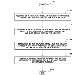
[0077] Figure 11 shows a flow diagram depicting an overall method, some of
which may be performed as a program executing on a processor. The method
starts (block 1100) receiving, by a computer system, an indication of
rotational
drilling time and slide drilling time for a wellpath (block 1102); calculating
a value
indicative of tortuosity for the wellpath based on the indication of
rotational drilling
time and slide drilling time for the wellpath (block 1104); determining, by
the
computer system, that the wellpath exceeds a tortuosity threshold, the
determining based on the value indicative of tortuosity (block 1106); and
changing
a drilling parameter regarding the wellpath responsive to determining that the
wellpath exceeds the tortuosity threshold (block 1108). Thereafter, the method
ends (block 1110).
[0078] It is noted that while theoretically possible to perform some or all
the
calculations discussed above by a human using only pencil and paper, the time
measurements for human-based performance of such tasks may range from
man-hours to man-years, if not more. Thus, this paragraph shall serve as
support
for any claim limitation now existing, or later added, setting forth that the
period of
time to perform any task described herein less than the time required to
perform
the task by hand, less than half the time to perform the task by hand, and
less
than one quarter of the time to perform the task by hand, where "by hand"
shall
refer to performing the work using exclusively pencil and paper.
CA 02919506 2016-01-26
WO 2015/030799
PCT/US2013/057580
17
[0079] From the description provided herein, those skilled in the art are
readily
able to combine software created as described with appropriate general-purpose
or special-purpose computer hardware to create a computer system and/or
computer sub-components in accordance with the various embodiments, to
create a computer system and/or computer sub-components for carrying out the
methods of the various embodiments and/or to create a non-transitory computer-
readable medium (i.e., not a carrier wave) that stores a software program to
implement the method aspects of the various embodiments.
[0080] References to "one embodiment," "an embodiment," "some
embodiment," "various embodiments," or the like indicate that a particular
element or characteristic is included in at least one embodiment of the
invention.
Although the phrases may appear in various places, the phrases do not
necessarily refer to the same embodiment.
[0081] The above discussion is meant to be illustrative of the principles and
various embodiments of the present invention. Numerous variations and
modifications will become apparent to those skilled in the art once the above
disclosure is fully appreciated. For example, while the various embodiments
have been described in terms of calculating a tortuosity value based on a
ratio
of rotational drilling time to slide drilling time, this context shall not be
read as a
limitation as to the scope of one or more of the embodiments described ¨ the
same techniques may be used for other embodiments. It is intended that the
following claims be interpreted to embrace all such variations and
modifications.