Note: Descriptions are shown in the official language in which they were submitted.
CA 02919543 2016-01-26
WO 2015/016990 PCT/US2014/035237
SYSTEM AND METHOD FOR ESTIMATING A RESERVOIR PARAMETER USING
JOINT STOCHASTIC INVERSION OF MULTISOURCE GEOPHYSICAL DATA
FIELD
[0001] The present invention pertains in general to computation methods and
more
particularly to a computer system and computer implemented method for
estimating a reservoir
parameter using joint stochastic inversion of multisource geophysical data.
BACKGROUND
[0002] Multiple sources of geophysical data have been used for estimating
reservoir
parameters for many decades. Current approaches for geophysical inverse
problems are
primarily deterministic inversion methods, such as Gauss-Newton methods,
conjugate gradient
methods, and steepest decent techniques. These conventional methods have been
successfully
used to solve a wide range of complex inverse problems with tens of millions
of unknowns.
However, the solutions obtained using these conventional methods often depend
on the
choice of initial values and thus are local rather than global. In addition,
the deterministic
inversion methods provide very limited uncertainty information on the
estimated parameters.
[0003] Stochastic inversion methods have been recognized recently as a
powerful approach
for solving geophysical inverse problems. Stochastic methods have several
benefits over
deterministic inversion methods. For example, stochastic inversion methods can
provide
extensive information about unknown parameters. In addition, in stochastic
inversion methods,
the inversion results are almost independent of initial values and therefore
global and robust.
SUMMARY
[0004] An aspect of the present invention is to provide a method for
estimating a reservoir
parameter, wherein the method is implemented in a computer system comprising
one or more
processors configured to execute one or more computer program modules. The
method includes
calculating, by the one or more processors, a plurality of priors using a
Markov random field, the
plurality of priors comprising probability distributions of a plurality of
litho-types; calculating,
1
CA 02919543 2016-01-26
WO 2015/016990 PCT/US2014/035237
by the one or more processors, posterior distributions based on the priors,
the posterior
distribution depending upon measured geophysical data, geophysical attributes
and reservoir
parameters; and determining, by the one or more processors, at least a portion
of litho-types in
the plurality of litho-types that correlate most with the measured geophysical
data.
[0005] Another aspect of the present invention is to provide a system for
estimating a reservoir
parameter. The system includes one or more processors configured to: (a)
calculate a plurality of
priors using a Markov random field, the plurality of priors comprising
probability distributions of
a plurality of litho-types; (b) calculate posterior distributions based on the
priors, the posterior
distribution depending upon measured geophysical data, geophysical attributes
and reservoir
parameters; and (c) determine at least a portion of litho-types in the
plurality of litho-types that
correlate most with the measured geophysical data.
[0006] Although the various steps of the method according to one embodiment of
the
invention are described in the above paragraphs as occurring in a certain
order, the present
application is not bound by the order in which the various steps occur. In
fact, in alternative
embodiments, the various steps can be executed in an order different from the
order described
above or otherwise herein.
[0007] These and other objects, features, and characteristics of the present
invention, as well
as the methods of operation and functions of the related elements of structure
and the
combination of parts and economies of manufacture, will become more apparent
upon
consideration of the following description and the appended claims with
reference to the
accompanying drawings, all of which form a part of this specification, wherein
like reference
numerals designate corresponding parts in the various figures. It is to be
expressly understood,
however, that the drawings are for the purpose of illustration and description
only and are not
intended as a definition of the limits of the invention. As used in the
specification and in the
claims, the singular form of "a", "an", and "the" include plural referents
unless the context
clearly dictates otherwise.
BRIEF DESCRIPTION OF THE DRAWINGS
[0008] In the accompanying drawings:
2
CA 02919543 2016-01-26
WO 2015/016990 PCT/US2014/035237
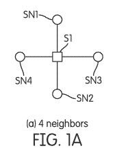
[0009] FIG. lA depicts a configuration of a first-order Markov random field on
a two-
dimensional (2D) inversion domain, where a given site Si has 4 neighboring
sites SN1, SN2,
SN3 and 5N4, located north of Si, south of Si, east of Si and west of Si,
respectively;
[00010] FIG. 1B depicts a configuration of a second-order Markov random field
on a 2D
inversion domain, where a given site Si has 8 neighboring sites SN1, 5N2, 5N3
and 5N4, 5N5,
5N6, 5N7 and 5N8 located north of Si, south of Si, east of Si, west of Si,
south-east of Si,
south-west of Si, north-east of Si and north-west of Si, respectively;
[00011] FIG. 2A depicts a configuration of a site on a three-dimensional (3D)
inversion domain
having 6 neighboring sites;
[00012] FIG. 2B depicts a configuration of a site on a 3D inversion domain
having 18
neighboring sites;
[00013] FIG. 2C depicts a configuration of a site on a 3D inversion domain
having 26
neighboring sites;
[00014] FIG. 3A depicts a first example of a possible two-dimensional
pictogram of a prior
information f(L) with two litho-types and no spatial correlation, according to
an embodiment of
the present invention;
[00015] FIG. 3B depicts a second example of a possible two-dimensional
pictogram of the prior
information f(L) with two litho-types and some spatial correlation, according
to an embodiment
of the present invention;
[00016] FIG. 3C depicts a third example of a possible two-dimensional
pictogram of the prior
information f(L) with three lithotypes and no spatial correlation, according
to an embodiment of
the present invention;
[00017] FIG. 3D depicts a fourth example of a possible two-dimensional
pictogram of the prior
information f(L) with three lithotypes and some spatial correlation, according
to another
embodiment of the present invention; and
3
CA 02919543 2016-01-26
WO 2015/016990 PCT/US2014/035237
[00018] FIG. 4 is a schematic diagram representing a computer system for
implementing the
method, according to an embodiment of the present invention.
DETAILED DESCRIPTION
[00019] According to an embodiment of the present invention, there is provided
a stochastic
method based on the Bayesian framework to jointly invert 2D or 3D multiple
types of
geophysical data.
[00020] In one embodiment, categorical (or state) variables are introduced
into the inversion.
The categorical variables may have geological meaning, such as lithotypes or
facies such as
shale, sand, oil sand. The categorical variables may also be pure data-driven
clusters, for
example, clusters from classification of borehole data.
[00021] In one embodiment, 2D or 3D Markov random fields can be used to
describe the
spatial dependence of the state variables. It is assumed that rock-physics
models are state-
dependent probability distributions, either through statistical regression of
borehole logs or
mechanistic experimental analysis.
[00022] A hierarchical Bayesian model can be used to integrate multiple
sources of geophysical
data. Given vectors di, d2, ¨, dyi representing n different types of
geophysical data, such as
seismic amplitude-versus-angle (AVA) data, controlled source electromagnetic
(CSEM) data,
etc., the geophysical attribute vector xG on 2D or 3D grids, such as seismic P-
wave and S-wave
velocities, density, electrical resistivity, and so on can be estimated.
Furthermore, reservoir
parameter vector xR on the same or different grids, such as porosity, fluid
(i.e., water, oil, or gas)
saturation can also be estimated. Other parameters associated with geophysical
forward models,
characteristics of measurement errors, rock-physics models, etc. can also be
estimate.
[00023] OG and OR represent unknown parameters associated with geophysical
attribute xG (e.g.,
seismic P-wave velocity and seismic S-wave velocity, density, electrical
resistivity, etc.) and
reservoir parameter xR (e.g., porosity, fluid saturation, etc.), respectively.
These unknown
parameters are not necessarily linked to grids.
4
CA 02919543 2016-01-26
WO 2015/016990
PCT/US2014/035237
[00024] Categorical (or state) variables, which are hidden states in this
estimation, can be
introduced. For example, these state variables may have geological meaning,
such as variables
litho-types or variables derived from clusters of borehole log parameters. In
order to simplify the
joint inversion, the state variables can be severed as auxiliary variables.
The state variables can
be represented by vector L.
[00025] Within the Bayesian framework, a hierarchical model can be provided.
The model can
be expressed using the following equation (1).
f (XG, XR 5 OG 5 OR 5 LI& 5 d2 5===5 dn) c)c. f (di 5 d2 5 ===5 dn 1 XG 5 OG)
X f (XG 1 XR 5 OR, L) xf (XR 5 OR IL) xf (L) xf(OG) xf(OR) (1)
[00026] Equation (1) defines a joint posterior probability distribution
function of all unknown
parameters. The term f (di 5 d25 ===5 dn1 xG5 OG) in equation (1) is referred
to as the likelihood
function of geophysical data, which provides a link between the unknown
parameters 3iG
representing the geophysical attribute vector such as seismic velocity or
velocities, density,
electrical resistivity, etc.), OG representing associated coefficients that
relate the geophysical
attribute XG to some model functions or numerical simulations, and/or the
geophysical data di, d2
===5 dn. As it can be appreciated, the likelihood function is a multi-
parameter or multi-variable
function that depends on a number of parameters or variables. The likelihood
function expresses
the probability that the numerical simulation or function (e.g., regression)
of a given set of
unknown coefficient OG and the unknown parameters 3iG fits the geophysical
data di, d25 ===5 dn .
For example, if the numerical simulation or function fits the data well, the
likelihood function
should provide a relatively very large value. However, the likelihood function
f (di, d25 ===5 dn1
XG 5 OG) depends on the characteristics of its corresponding measurement
errors. That is, the
likelihood function depends, among other things, on the errors in the
determination of parameter
OG and in choosing a particular forward model when performing the simulation
or regression.
For example, multivariate Gaussian distribution is commonly used as a
likelihood function of
measurement data. However, if data have many outliers, a multivariate t-
distribution can be
selected instead in order to better accommodate the long tail in the
distribution.
[00027] The term f (xG 1 XR , OR, L) in equation (1) represents the state-
dependent rock-physics
models, which can be mechanistically meaningful clusters or pure data-driven
clusters. This
5
CA 02919543 2016-01-26
WO 2015/016990 PCT/US2014/035237
term often is described by a mixing Gaussian model. This term is referred to
as a reservoir
dependent likelihood function and provides the relationship between a
reservoir parameter XR
(e.g., such as porosity, fluid saturation, etc.) and geophysical parameter xG
(e.g., seismic velocity,
density, electrical resistivity, etc.). However, this relationship also
depends on the litho-type or
facies L. That is, for each facies or litho-type (Li, L2, L35...., La), a
relationship exists between
the reservoir parameter xR and geophysical parameter xG . Li, L25 L3....., L.
represent different
litho-types such as sand, shale, oil-sand, etc. The term f (xG 1 XR 5 OR, L)
in equation (1) is
unknown and may need to be estimated.
[00028] The term f (xR 5 OR 1 L) in equation (1) represents state-dependent
rock-physics
properties at a given site. This term provides the relationship between
reservoir parameter xR and
litho-type L. That is, given a certain litho-type L (e.g., sand, shale, etc.),
the probability of
having a certain reservoir parameter xR (e.g., a certain reservoir porosity)
may need to be
estimated.
[00029] The term f (L) is the joint distribution of the introduced state
variable and represents
the prior information. This term represents the probability of having a
certain lithology or litho-
type (e.g., sand, shale, etc.) at a certain location. This term is also
unknown and may need to be
estimated.
[00030] The terms f (0G) and f (OR) are prior distributions of hyper-
parameters, respectively,
prior distributions of reservoir model coefficients OR and prior distributions
of geophysical model
coefficients OG. These two terms may be treated as unknowns if the parameters
OG and OR
contain errors and are not obtained through the simulation or regression with
the desired
precision.
[00031] The term f (xG, xR 5 OG, OR, L 1 di, d2,¨, dn) represents the
posterior information which
is a probability distribution obtained by multiplying all the above defined
terms and represents
the information that is the conditional probability distribution of the
uncertainty given the
geophysical data. The process of calculating the posterior is described in
further detail in the
following paragraphs.
6
CA 02919543 2016-01-26
WO 2015/016990 PCT/US2014/035237
[00032] The Bayesian framework provides a pragmatic way to combine multisource
geophysical data for estimating unknown parameters as well as their associated
uncertainty
information. In one embodiment, Markov random fields (MRF) serve as prior
models of the
state variable L for 2D or 3D geophysical inversion. A Markov random field can
be defined as
follows.
[00033] In one embodiment, a finite index set (e.g., a set of sites, or
locations or grids) S is
provided. The finite index S contains one or more sites (locations or grids)
s. Although grids are
often used instead of sites or locations in geophysical inverse problems, the
term 'site' is more
generic because the term 'grid' often implies 2D or 3D regular grids but the
term 'site' does not.
Therefore, in the following paragraphs the term site will be used to include
any location on a grid
or otherwise. For each site in the index set S of sites (s e 5), there is
provided a finite space K of
states is, such as K = {1, 2, = = =, lf-} , where k is the total number of
states in this case.
[00034] In one embodiment, a neighbor 0(s) of a site s can be defined as
follows. A collection
0 = {0(s): s E S} of sets is called the neighborhood system, if a site does
not belong to the
neighborhood collection system (s 00 (s)) and t E0 (s) if and only if s E0
(t). The sites t that
belong to the neighborhood collection (t E0 (s)) are called neighbors of site
s. Instead of writing
the expression te 0 (s), the expression s ¨ t can also be written for
convenience. In addition, a
clique C can also be defined. A clique C is a subset of index set S if any two
different elements
of clique C are neighbors.
[00035] A random field it is a Markov random field with respect to the
neighborhood system
0(s), if for all states / belonging to finite space K (/ e K), the following
equation (2) can be
satisfied. Equation (2) is the definition of Markov random fields based on
local characteristics.
7C (Ls= / sl Lt= 1 t , t s) = 7C (Ls= / sl Lt= 1 t , te0 (s)) (2)
[00036] The following equation (3) is the global definition of Markov random
fields. The joint
probability of state vector L is given by equation (3).
m(L) = expf¨H(L))
(3)
Ez EK expf¨H(z))
7
CA 02919543 2016-01-26
WO 2015/016990 PCT/US2014/035237
where H is called the energy function or Hamiltonian, and E exp{ ¨ H (z)} is
the partition
function or normalizing constant. The probability measure defined in equation
(3) is the Gibbs
fields or measure. The Gibbs field defined by equation (3) is equivalent to
the Markov random
field defined by the local characteristic defined by equation (2). The
equivalence provides great
convenience for developing sampling methods and allows focusing on local
specification of
neighbors.
[00037] Geophysical inverse problems often use regular grids, which may have a
variable size.
For example, for 2D problems, there may be two ways to define neighborhood
systems. For
example, in one instance, adjacent neighboring sites of a given site in a 2D
grid can be selected
as south, east, and west adjacent sites. This case is referred to as the first-
order Markov random
field. FIG. lA depicts a configuration of a first-order Markov random field,
where a given site
Si has 4 neighboring sites SN1, SN2, SN3 and SN4, located north of Si, south
of Si, east of Si
and west of Si, respectively.
[00038] In another instance, adjacent neighboring sites of a given site in a
2D grid can be
selected as south, east, west, south-east, south-west, northeast, north-west
adjacent sites. This
case is referred to as the second-order Markov random field. FIG. 1B depicts a
configuration of
a second-order Markov random field, where a given site Si has 8 neighboring
sites SN1, 5N2,
5N3 and 5N4, 5N5, 5N6, 5N7 and 5N8 located north of Si, south of Si, east of
Si, west of Si,
south-east of Si, south-west of Si, north-east of Si and north-west of Si,
respectively.
[00039] Similarly, neighborhood systems for 3D grids can also be defined. FIG.
2A depicts a
configuration of a site having 6 neighboring sites. The 6 neighboring sites
include the same
neighbors SN1, 5N2, 5N3 and 5N4 shown in FIG. lA and 2 additional neighbors
that are located
out of the plane containing the neighbors SN1, 5N2, 5N3 and 5N4. FIG. 2B
depicts a
configuration of a site having 18 neighboring sites. The 18 neighboring sites
include the same
neighbors SN1, 5N2, 5N3, 5N4, 5N5, 5N6, 5N7 and 5N8 shown in FIG. 1B and 10
additional
neighbors that are located out of the plane containing the neighbors SN1, 5N2,
5N3, 5N4, 5N5,
5N6, 5N7 and 5N8. FIG. 2C depicts a configuration of a site having 26
neighboring sites. The
26 neighboring sites include the same neighbors SN1, 5N2, 5N3, 5N4, 5N5, 5N6,
5N7 and 5N8
8
CA 02919543 2016-01-26
WO 2015/016990
PCT/US2014/035237
shown in FIG. 1B and 18 additional neighbors that are located out of the plane
containing the
neighbors SN1, SN2, SN3, SN4, SN5, SN6, SN7 and SN8.
[00040] With a properly defined neighbor system, Potts models can be used to
describe the
spatial dependence of a site on its neighbor sites. This dependence is
provided by the following
equation (4).
7C (L) oc exp {Eies ai (0) x exp j I [li = (4)
[00041] The term exp {EiEs a1 (13] represents the external fields or
likelihood functions of
available data. Three different methods can be used to draw samples of the
state variables, which
include Swendsen-Wang algorithms, Wolff algorithms, and Gibbs samplers.
[00042] FIG. 3A depicts a first example of a possible two-dimensional
pictogram of the prior
information f(L), with two lithotypes, according to an embodiment of the
present invention. As
stated above the prior information f(L) represents the probability of having a
certain lithology or
litho-type (e.g., sand, shale, etc.) at a certain location. The x-direction
and y-direction in FIG.
3A represents the horizontal and vertical directions (e.g., east-west and
north-south directions).
The grey blocks represent a position of a first facies or litho-type, for
example, shale, while the
white blocks represent a position of a second facies or litho-type, for
example, sand. As shown
in FIG. 3A, there is no correlation between neighboring same litho-types and
the first and second
litho-types appear randomly dispersed in the x-direction and y-direction.
[00043] FIG. 3B depicts a second example of a possible two-dimensional
pictogram of the prior
information f(L), with two lithotypes, according to an embodiment of the
present invention. The
x-direction and y-direction in FIG. 3B represents the horizontal and vertical
directions (e.g., east-
west and north-south directions). The grey blocks represent a position of the
first facies or litho-
type, for example, shale, while the white blocks represent a position of the
second facies or litho-
type, for example, sand. As shown in FIG. 3B, there is some correlation
between neighboring
same litho-types and the first and second litho-types appear clustered or form
clusters in the x-y
space.
9
CA 02919543 2016-01-26
WO 2015/016990 PCT/US2014/035237
[00044] FIG. 3C depicts a third example of a possible two-dimensional
pictogram of the prior
information f(L), with three litho-types, according to an embodiment of the
present invention.
The x-direction and y-direction in FIG. 3C represents the horizontal and
vertical directions (e.g.,
east-west and north-south directions). The dark grey blocks represent a
position of a first facies
or litho-type, for example, shale, the white blocks represent a position of a
second facies or litho-
type, for example, sand, and the lighter grey blocks represent a position of a
third facies or litho-
type, for example, sand-oil. As shown in FIG. 3C, there is no correlation
between neighboring
same litho-types and the first, the second and third litho-types appear
randomly dispersed in the
x-direction and y-direction, similar to the example shown in FIG. 3A.
[00045] FIG. 3D depicts a fourth example of a possible two-dimensional
pictogram of the prior
information f(L), with three lithotypes, according to an embodiment of the
present invention.
The x-direction and y-direction in FIG. 3D represents the horizontal and
vertical directions (e.g.,
east-west and north-south directions). The dark grey blocks represent a
position of a first facies
or litho-type, for example, shale, the white blocks represent a position of a
second facies or litho-
type, for example, sand, and the lighter grey blocks represent a position of a
third facies or litho-
type, for example, sand-oil. As shown in FIG. 3D, it is apparent that there is
some correlation
between neighboring same litho-type. The first, the second and third litho-
types appear clustered
in the x-y space, similar to the example shown in FIG. 3B. In FIG. 3D, there
is more spatial
dependence of the distribution of the various litho-types. The spatial
correlation in the x-
direction is four times the spatial correlation in the y-direction. That is,
there is a higher
probability (e.g., four times) of two blocks of a same litho-type being
connected in the x-
direction than in the y-direction.
[00046] FIGs. 3A-3D represent only one realization or sample of the prior
f(L). There are a
plurality (e.g., thousands) of such realizations or samples of the prior f(L).
For example, a
plurality of realizations or samples similar to the one shown in FIG. 3A can
be generated. These
plurality of realizations or patterns are similar in nature in that the
probability dependence in x
and y directions is the same but having different distributions of the blocks
representing the
litho-types. In other words, for two realizations, the patterns obtained may
be somewhat
different but the probability dependence along the x-direction and the y-
direction remains the
CA 02919543 2016-01-26
WO 2015/016990 PCT/US2014/035237
same. This same analysis can be applied for the other realizations shown in
FIGs. 3B, 3C and
3D.
[00047] The appropriate input of prior f(L) into equation (1) can be selected
depending upon an
observation of the geology of an area of interest. For example, it may be
determined from
geological observations that there is more correlation in the x-direction than
in the y-direction for
the various litho-types in which case the model shown in FIG. 3B or FIG. 3D
may be more
appropriate in the calculation of the various unknown parameters in equation
(1). By providing
more information or data on the priors, the random field of the prior f(L) can
be narrowed in
equation (1). As a result, the speed of calculation of the posterior
information in equation (1) can
be increased.
[00048] In the following paragraphs, a method is described for calculating the
posterior
information. In one embodiment, a hybrid method can be used to draw many
samples from the
joint probability distributions given in equation (1). The hybrid method
includes several major
steps. The first step is to assign initial values, which are arbitrary as long
as they physically
justified, to all the unknown parameters xG, xR, OG , OR, and L. The initial
values are referred to
as XG(13), XIV, O(G0), ORM and L" , respectively. Let t be an iteration index.
For the initial values,
it can be set to be 0, i.e., t=0.
[00049] In the second step, the hybrid method updates geophysical attributes,
such as seismic
velocity, density or electrical resistivity, or any combination thereof, by
randomly selecting one
of suitable sampling methods with a pre-set probability. In one embodiment,
the sampling
methods include Metropolis-Hastings, adaptive Metropolis-Hastings, or slice
sampling methods.
The samples are referred to as xG(t).
[00050] In the third step, the hybrid method further updates hyper-parameters
OG and OR by
selecting a suitable sampling method among various Metropolis-Hastings or
slice sampling
methods. The samples are referred to as O(Pand OR(t).
[00051] In the fourth step, the hydrid method further updates reservoir
parameters, such as
porosity or fluid saturation or both, using similar sampling methods. Other
reservoir parameters
11
CA 02919543 2016-01-26
WO 2015/016990 PCT/US2014/035237
may also be updated. In one embodiment, the sampling methods may include Gibbs
samplers if
analytical conditional distributions are obtainable. The samples are referred
to as xR(t).
[00052] In the fifth step, the hybrid method updates state variables at all
sites by randomly
selecting one sampling method among the Swendsen-Wang algorithm, Wolf
algorithms, or
Gibbs samplers with a pre-set probability. The randomly selected litho-types
are referred to as
samples to as L(t). Examples of such samples or realizations are shown and
described above
with respect to Figs. 3A-3D. In the particular examples shown in FIGs. 3A-3D,
a Wolf
algorithm is used to calculate and generate the probability distribution of
the various litho-types
in the x-direction and the y-direction.
[00053] The hybrid method includes repeating the above steps iteratively. The
hybrid method
includes determining whether a pre-set number of iteration is reached. If the
number of pre-set
iteration is not reached, repeating the above steps 2-5 through the loop until
a number a pre-set
total number of iterations is reached. If the number of pre-set iteration is
reached, the method
ends.
[00054] The pre-set probabilities for choosing sampling methods are tuning
parameters. For
example, in each step, we can pick Metropolis-Hastings with probability of 20%
and slice
sampling with probability of 80%. It is noted that the tuning parameters only
affect the speed of
convergence but not the results because when the sampling processes reaches
the stationary
stages of the joint posterior distribution, it does not matter how they get
the stage by the
properties of Markov chain Monte Carlo (MCMC) methods. Without prior
information on the
choice of tuning parameters, we typically set the tuning parameters being
uniform in the
preliminary stage and change them after gaining some experience through the
preliminary runs.
[00055] We combine categorical based MC MC sampling methods with other MCMC
sampling strategies for continuous variables to achieve the best sampling
efficiency.
[00056] As it can be appreciated from the above paragraphs, one aspect of the
present invention
is to use prior information of unknown litho-types to determine a posterior
probability by
conditioning on a set of data (seismic data for example) to narrow down the
field from a plurality
of litho-type distributions to distributions that correlate more closely with
measured geophysical
12
CA 02919543 2016-01-26
WO 2015/016990 PCT/US2014/035237
data d. When the posterior information is determined the probability of having
a certain litho-
type at a certain position can be quantified.
[00057] As it can be appreciated from the above paragraphs, there is provided
a method for
estimating a reservoir parameter, wherein the method is implemented in a
computer system
comprising one or more processors configured to execute one or more computer
program
modules. The method includes calculating, by the one or more processors, a
plurality of priors
J(L) using a Markov random field, the plurality of priors comprising
probability distributions of a
plurality of litho-types L; calculating, by the one or more processors,
posterior distributions f (xG,
xR , OG, OR, L I di, d2 ,===5 d, ) based on the priors f(L), the posterior
distribution f (xG, xR 5 OG, OR,
L I di, d25..., dn) depending upon measured geophysical data di, d25===5 dn,
geophysical attributes
xG and reservoir parameters xR; and determining, by the one or more
processors, at least a portion
of litho-types in the plurality of litho-types L that correlate most with the
measured geophysical
data di 5 d25===,dn.
[00058] In one embodiment, the method further includes calculating, by the one
or more
processors, a geophysical likelihood function of geophysical data f (di, d25
===5 dn1 xG, OG), the
geophysical likelihood function providing a link between geophysical
attributes xc and
geophysical model coefficients OG and the geophysical data di,d25===5 dn.
[00059] In one embodiment, the method further includes calculating, by the one
or more
processors, a reservoir dependent likelihood function f (xG 1 XR , OR, L), the
reservoir dependent
likelihood function f (xG1 xR 5 OR, L) providing a link between a plurality of
reservoir parameters
xR and the plurality geophysical attributes xG for each of the plurality of
litho-types L5 with litho-
types being types of sediments and/or rocks (e.g. sand, shale, and oil-sand).
[00060] In one embodiment, the method further includes calculating, by the one
or more
processors, a state-dependent rock-physics term f (xR 5 OR 1 L), the state-
dependent rock physics
term f (xR , OR 1 L) providing a relationship between the plurality of
reservoir parameters xR and
the plurality of litho-types L and a reservoir model coefficients OR.
13
CA 02919543 2016-01-26
WO 2015/016990 PCT/US2014/035237
[00061] In one embodiment, the method further includes calculating, by the one
or more
processors, prior distributions f (OR) of the reservoir model coefficients OR
and prior distribution
f(OG) of the geophysical model coefficients 0G.
[00062] In one embodiment, calculating, by the one or more processors, the
posterior f (xG, XR 5
OG 5 OR, L I di, d2 5===, cl, ) further comprises calculating the posterior
based upon the geophysical
likelihood function of geophysical data f (di 5 d2 5 === 5 di 1 xG5 OG )5 the
reservoir dependent
likelihood function f (xG1 xR 5 OR, L), the state-dependent rock-physics term
f (xR 5 OR 1 L), the
prior distributions f (OR) of the reservoir model coefficients OR, and the
prior distribution f (0G) of
the geophysical model coefficients OG.
[00063] In one embodiment, the method or methods described above can be
implemented as a
series of instructions which can be executed by a computer. As it can be
appreciated, the term
"computer" is used herein to encompass any type of computing system or device
including a
personal computer (e.g., a desktop computer, a laptop computer, or any other
handheld
computing device), or a mainframe computer (e.g., an IBM mainframe), or a
supercomputer (e.g.,
a CRAY computer), or a plurality of networked computers in a distributed
computing
environment.
[00064] For example, the method(s) may be implemented as a software program
application
which can be stored in a computer readable medium such as hard disks, CDROMs,
optical disks,
DVDs, magnetic optical disks, RAMs, EPROMs, EEPROMs, magnetic or optical
cards, flash
cards (e.g., a USB flash card), PCMCIA memory cards, smart cards, or other
media.
[00065] Alternatively, a portion or the whole software program product can be
downloaded
from a remote computer or server via a network such as the internet, an ATM
network, a wide
area network (WAN) or a local area network.
[00066] Alternatively, instead or in addition to implementing the method as
computer program
product(s) (e.g., as software products) embodied in a computer, the method can
be implemented
as hardware in which for example an application specific integrated circuit
(ASIC) can be
designed to implement the method.
14
CA 02919543 2016-01-26
WO 2015/016990 PCT/US2014/035237
[00067] Various databases may be used. The databases may include or interface
to, for
example, an OracleTM relational database sold commercially by Oracle
Corporation. Other
databases, such as InformixTM, DB2 (Database 2) or other data storage,
including file-based, or
query formats, platforms, or resources such as OLAP (On Line Analytical
Processing), SQL
(Standard Query Language), a SAN (storage area network), Microsoft AccessTM or
others may
also be used, incorporated, or accessed. The database may comprise one or more
such databases
that reside in one or more physical devices and in one or more physical
locations. The database
may store a plurality of types of data and/or files and associated data or
file descriptions,
administrative information, or any other data.
[00068] FIG. 4 is a schematic diagram representing a computer system 100 for
implementing
the method, according to an embodiment of the present invention. As shown in
FIG. 4, computer
system 100 comprises a processor (e.g., one or more processors) 102 and a
memory 104 in
communication with the processor 102. The computer system 100 may further
include an input
device 106 for inputting data (such as a keyboard, a mouse or the like) and an
output device 108
such as a display device for displaying results of the computation. The
computer system 100
may also include or be connected to a storage device 110. The storage device
110 can host a
database or other data storage.
[00069] As can be appreciated from the above description, the computer system
100 includes
one or more processors 102 configured to execute one or more computer program
modules to: (a)
calculate a plurality of priors using a Markov random field, the plurality of
priors comprising
probability distributions of a plurality of litho-types; (b) calculate
posterior distributions based on
the priors, the posterior distribution depending upon measured geophysical
data, geophysical
attributes and reservoir parameters; and (c) determine at least a portion of
litho-types in the
plurality of litho-types that correlate most with the measured geophysical
data.
[00070] Although the invention has been described in detail for the purpose of
illustration based
on what is currently considered to be the most practical and preferred
embodiments, it is to be
understood that such detail is solely for that purpose and that the invention
is not limited to the
disclosed embodiments, but, on the contrary, is intended to cover
modifications and equivalent
arrangements that are within the spirit and scope of the appended claims. For
example, it is to be
CA 02919543 2016-01-26
WO 2015/016990 PCT/US2014/035237
understood that the present invention contemplates that, to the extent
possible, one or more
features of any embodiment can be combined with one or more features of any
other
embodiment.
[00071] Furthermore, since numerous modifications and changes will readily
occur to those of
skill in the art, it is not desired to limit the invention to the exact
construction and operation
described herein. Accordingly, all suitable modifications and equivalents
should be considered
as falling within the spirit and scope of the invention.
16