Note: Descriptions are shown in the official language in which they were submitted.
CA 02919633 2016-01-27
WO 2015/030754
PCT/US2013/057110
STATIC EARTH MODEL GRID CELL SCALING AND PROPERTY
RE-SAMPLING METHODS AND SYSTEMS
BACKGROUND
Modem oil field operators demand a great quantity of information relating to
the
parameters and conditions encountered downhole. Among the types of information
most
sought is porosity and permeability, i.e., the ability of a fluid (usually
oil, water, gas, etc.) to
flow through a geologic formation. The permeability of a reservoir is a
function of the
interconnectedness of the available pore space, as well as, pore size
distribution, flow
direction, grain size and sorting, shale content, non-connecting vugs, and
fractures. To
facilitate characterizing and simulating formation behavior, geologic grids
are employed, in
which grid cells (blocks) of the geologic grid are assigned values for
formation parameters
such as porosity, permeability, and/or others. As the size of grid cells
decreases in size, grid
computations become more complex and time-consuming. On the other hand, as the
size of
grid cells increases, grid computations become more simplistic and are less
likely to
accurately represent downhole conditions. Determining an appropriate grid cell
size is not a
trivial task.
BRIEF DESCRIPTION OF THE DRAWINGS
A better understanding of the various disclosed embodiments can be obtained
when
the following detailed description is considered in conjunction with the
attached drawings, in
which:
FIG. 1 shows an illustrative process for determining a static earth model.
FIG. 2 shows an illustrative hydrocarbon production system.
FIG. 3 shows illustrative components for a control system.
FIG. 4 shows illustrative computer system to control data collection and
production.
FIG. 5 shows an illustrative data volume in three dimensions.
FIG. 6 shows an illustrative imaging system.
FIG. 7 shows an illustrative grid cell scaling and property re-sampling
method.
It should be understood that the drawings and detailed description are not
intended to
limit the disclosed embodiments to the particular forms shown, but on the
contrary, the
-1-
CA 02919633 2016-01-27
WO 2015/030754 PCT/US2013/057110
intention is to cover all modifications, equivalents and alternatives falling
within the scope of
the appended claims.
DETAILED DESCRIPTION
Hydrocarbon production monitoring or planning involves the collection of
measured
s data from within and around the wells of a reservoir. Such data may
include, but is not
limited to, water saturation, water and oil cuts, fluid pressure and fluid
flow rates. As the data
is collected, it is archived into a historical database. The collected data,
however, mostly
reflects conditions immediately around the reservoir wells. To provide a more
complete
picture of the state of a reservoir, simulations are executed that model the
overall behavior of
io the entire reservoir based on the collected data, both current and
historical. These simulations
predict the reservoir's overall current state, producing simulated data values
both near and at
a distance from the wellbores.
The accuracy of reservoir simulation results is limited by the static earth
model
depicting the subsurface formation as well as various other inputs such as
rock-fluid
is descriptions and pressure-volume-temperature characterizations. To
facilitate characterizing
and simulating reservoir behavior, static earth models employ geologic grids,
where grid cells
of the geologic grid are assigned the same geological parameter value (e.g.,
porosity and
permeability values). In accordance with at least some embodiments, the
disclosed methods
and systems determine a static earth model using a grid cell scaling process,
in which
20 predetermined rules determine the amount of scaling that is applied to
at least some of the
grid cells of a static earth model. After the scaling process is complete, the
static earth model
may be assessed to determine its accuracy relative to the pre-scaled version.
For example, in
some embodiments, the post-scaled static earth model is assessed by comparing
pre-scaled
and post-scaled values for static property connectivity, tortuosity, Euler
number, streamline
25 simulation, and/or full-filed reservoir simulation. If needed, geologic
feature adjustments
(lithotype proportion maps, facies relationships, distribution of
petrophysical properties
within a defined depositional facies) and/or grid scaling adjustments
(upscaling or
downscaling) are made to the static earth model until the assessment results
indicate that
attributes of the post-scaled static earth model are accurate to within a
threshold tolerance
30 level and that further scaling is detrimental to the integrity of the
geology and/or production
history associated with the model. The resulting static earth model can then
be used for
ongoing operations such as fluid flow simulations.
- 2 -
CA 02919633 2016-01-27
WO 2015/030754 PCT/US2013/057110
As used herein "tortuosity" refers to a ratio computed as an arc length to
straight line
distance through a medium in the direction of macroscopic flow. The
computation of
tortuosity may be performed statically, using petrophysical properties defined
as a connected
geobody and/or dynamically using streamlines. The difference in tortuosity
between
s homogeneous and heterogeneous cases (for both static and dynamic models)
indicate the
possible effects of rock property heterogeneity, which produce a divergence in
the flow path,
and/or multiphase flow effects in the dynamic model (e.g., fluid retention due
to wettability
or isolation due to capillarity). Also, changes in tortuosity may be
determined by comparing
histograms of tortuosity for respective static and dynamic models to those
computed from a
ie given petrophysical realization or post-process streamline bundle.
If needed, geologic feature adjustments (lithotype proportions, facies
relationships,
distribution of petrophysical properties within a defined depositional facies)
and/or grid
scaling adjustments (upscaling or downscaling) are made to the static earth
model until the
assessment results indicate that attributes of the post-scaled static earth
model are accurate to
is within a threshold tolerance level and that a scaling limit has been
reached. The resulting
static earth model can then be used for ongoing operations such as fluid flow
simulations.
FIG. 1 shows an illustrative process 10 for determining a static earth model.
The
process includes a data analysis block 14 that receives well log input from
block 12. The well
logs correspond to collected data that may include, but is not limited to,
porosity,
zo permeability, resistivity, and gamma ray. Here data quality is assessed
and outliers are
removed such that spurious data is not introduced into the developed model.
Block 12 also
provides a framework, which corresponds to structural rules for a static earth
model based on
framework interpretation and knowledge of the depositional environment. The
stratigaphic
modeling block 16 uses the framework to build a geocellular grid that honors
the internal
zs bedding geometries resulting from sedimentation.
At lithotype proportion map creation block 18, a lithotype proportion map that
defines
grouped proportion curves and/or smoothed lithotype proportions. The generated
lithotype
proportion map is provided to a facies modeling block 20 that generates one or
more
depositional facies models (e.g., based on stochastic simulation methods),
which may be used
30 as a template for the mathematical distribution of petrophysical
properties within a reservoir
or formation. For example, in process 10, the one or more facies models are
input to a
petrophysical modeling block 22, which mathematically distributes
petrophysical properties
within a static earth model using spatial constraints of the one or more
facies models.
- 3 -
CA 02919633 2016-01-27
WO 2015/030754 PCT/US2013/057110
In at least some embodiments, the petrophysical features are input to a post
processing
block 24 that estimates volumetric characteristic such as original oil in
place, gross rock
volume, and recoverable hydrocarbon. The post processing block 24 also may
quantify static
property uncertainty characteristics and may execute a single-phase fluid
numerical
s simulation in the static earth model in order to assess the effect of the
distributed
petrophysical properties and the spatial constraints resulting from the
depositional facies.
The petrophysical features also are input to a grid cell scaling/property re-
sampling
controller block 26 that determines the grid cells sizes for each of a
plurality of grid cells, and
assigns petrophysical property values (e.g., porosity and permeability values)
for each grid
io cell. In at least some embodiments, the grid cell scaling controller
block 26 determines the
degree of scaling based on predetermined rules, including: 1) an amount of
matrix grid
(ROOT) cells required; 2) an amount of local grid refinement (LGR) necessary
to properly
describe geologic features and unconformities; 3) a degree of static
tortuosity due to input
petrophysical properties; 4) a degree of static tortuosity due to input
depositional facies
is properties; 5) a degree of dynamic tortuosity for a fluid saturation
volume resulting from a
single phase flow model execution; 6) a degree of dynamic tortuosity for a
fluid saturation
volume resulting from a multi-phase flow model execution; and/or 7) a
minimization of
relative error in Euler Number.
More specifically, for rule 1, the maximum number of scaled cells that are
desired for
20 a flow simulation model can be indicated. For rule 2, the maximum amount
of LGR
necessary to properly describe geologic in the flow simulation model can be
indicated. For
rule 3, a combination of petrophysical property filtering is applied. First,
the tortuosity for a
pseudo grid volume which has homogeneous property values is computed in all
active,
geometrically and petrophysically relevant cells. The tortuosity (e.g.,
histograms) of this
zs homogeneous pseudo grid volume represents the effects of over-scaling on
the intended grid,
and is compared with the original (pre-scaled/re-sampled) grid as well as each
successive
attempt at scaling. Grid tortuosity approaching the homogeneous pseudo grid
volume
tortuosity indicates excessive data smearing due to scaling/re-sampling. Thus,
the user
specified condition for rule 3 may be to honor the tortuosity distribution
computed for the
30 pre-scaled grid within an indicated tolerance level. With rule 3, rock
property continuity is
preserved for selected ranges of petrophysical properties when the tortuosity
of the range of
petrophysical properties is maintained across varying degrees of upscaling.
For rule 4, a combination of petrophysical property filtering is applied as in
rule 3.
However, rule 4 incorporates deposition facies as the target property for
computing
- 4 -
CA 02919633 2016-01-27
WO 2015/030754 PCT/US2013/057110
tortuosity. With rule 4, spatial continuity is preserved when the tortuosity
of the depositional
facies is maintained across varying degrees of upscaling.
For rule 5, a single phase approximation for fluid flow modeling is used, such
as is
available in DecisionSpace Earth Modeling, to compute streamlines for the
original (pre-
scaled) grid. Also, single phase flow streamlines for a pseudo-grid (the
original grid but with
homogeneous rock properties specified) are computed. The single-phase flow
streamlines
provide a baseline for determining excessive upscaling. The dynamic tortuosity
is determined
by computing tortuosity of the generated streamlines such that successive
iterations of
upscaling produce coincident distributions of tortuosity between streamline
distributions
computed for the pre-scaled grid and the homogenous volume. The user-specified
condition
for rule 5 would be to honor the tortuosity distribution computed for the pre-
scaled grid
within an indicated tolerance level.
For rule 6, a multi-phase approximation for fluid flow modeling is used, such
as is
available in DecisionSpacee Nexus, to compute streamlines for the original
(pre-scaled) grid.
Also, multi-phase flow streamlines for a pseudo-grid (the original grid but
with homogeneous
rock properties specified) are computed. The multi-phase flow streamlines
provide a baseline
for determining excessive upscaling. The dynamic tortuosity is determined by
computing
tortuosity of the generated streamlines such that sequential iterations of
upscaling produce
coincident distributions of tortuosity between streamline distributions
computed for the pre-
scaled grid and the homogenous grid volume. Multi-phase flow modeling in the
grid provides
a description of dynamic fluid property effects in the reservoir model. The
user-specified
condition for rule 6 would be to honor the tortuosity distribution computed
for the pre-scaled
grid within an indicated tolerance level.
For rule 7, the Euler Number (normalized by volume) for the pre-scaled grid is
computed based on a predefined property filter and connectivity criterion;
creating a single or
multiple characteristic geobodies that are representative of hydraulic flow
units (or
production zones) in the reservoir. The Euler Number criteria that is applied
in the scaling
process is designated, and corresponds to a pre-scaled grid Euler Number plus
an epsilon
(deviation) term. Subsequently, the Euler Number (normalized by volume) for
each scaled
grid is computed. The applied scaling should have minimum degree of computed
grid scaling
and should honor the Euler Number criterion from the pre-scaled grid.
In at least some embodiments, the scaling process is combined with a
validation
procedure, in which an initial history match run (i.e., without any
modifications to grid
transmissibilities) is performed to verify whether flow rates and cumulative
produced fluid
- 5 -
= CA 02919633 2016-01-27
WO 2015/030754
PCT/US2013/057110
volumes can be matched. Thus, an automated scaling process can be combined
with industry
workflows for determining the type and degree of scaling to be performed.
Further, in at least
some embodiments, software tools (e.g., DecisionSpace Earth Modeling "See-It-
Now"
capability) may be employed a priori as a part of project planning between the
geo-modeler
and the reservoir engineer. The use of such software tools would allow the geo-
modeler and
reservoir engineer to investigate the degree of scaling in a subset of the
grid in which all full-
field data is honored before the full-field static earth model is applied to a
project.
Once an iteration of scaling and property re-sampling is complete, a
determination is
made regarding whether attributes of the static earth model are within a
tolerance threshold at
in block
28. For example, the tolerance threshold may be based on pre-scaled values for
connectivity, tortuosity, and/or Euler number. In such case, the determination
of block 28
may involve comparing post-scaled values for connectivity, tortuosity, and/or
Euler number
with corresponding pre-scaled values. If attributes of the scaled static earth
model are within
the tolerance threshold (determination block 28), then the model is applied to
reservoir
simulations or other operations at block 30. Otherwise, the process 10 returns
to block 26,
where calibration rules and/or user input are applied to update the static
earth model. As an
example, the calibration rules and/or user input may adjust the grid cell
scaling (upscaling or
downscaling) of the static earth model using predetermined connectivity,
tortuosity, and/or
Euler number values for the next iteration of scaling. Further, the
calibration rules and/or user
zo input
may adjust lithotype proportions, facies relationships, distribution of
petrophysical
properties within a defined depositional facies, or other geological features
of the static earth
model. The process of adjusting the grid scale and/or otherwise adjusting the
static earth
model may continue until attributes of the static earth model are determined
to be within a
tolerance threshold.
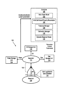
FIG. 2 shows an illustrative hydrocarbon production system 100. The
illustrated
hydrocarbon production system 100 includes a plurality of wells 104 extending
from a
reservoir 102, where the arrows representing the wells 104 show the direction
of fluid flow
(i.e., wells 104 represent production wells). Although only production wells
are shown,
hydrocarbon production system 100 could also include injector wells. Further,
the
hydrocarbon production system 100 also includes well log and seismic data
collection 105 at
wells 104.
In FIG. 2, a surface network 106 transports fluid from the wells 104 to a
separator
110, which directs water, oil, and gas to separate storage units 112, 114, and
116. The water
storage unit 112 may direct collected water back to reservoir 102 or
elsewhere. The gas
- 6 -
= CA 02919633 2016-01-27
=
WO 2015/030754
PCT/U52013/057110
storage unit 114 may direct collected gas back to reservoir 102, to a gas lift
interface (not
shown), or elsewhere. The oil storage unit 116 may direct collected oil to one
or more
refineries. In different embodiments, the separator 110 and storage units 112,
114, and 116
may be part of a single facility or part of multiple facilities associated
with the hydrocarbon
s production system model 100. Although only one oil storage unit 116 is
shown, it should be
understood that multiple oil storage units may be used in the hydrocarbon
production system
100. Similarly, multiple water storage units and/or multiple gas storage units
may be used in
the hydrocarbon production system 100.
In FIG. 2, the hydrocarbon production system 100 includes a controller 120
with
ro various components related to the disclosed methods and systems. The
controller 120
represents, for example, one or more computers executing software or other
instructions. As
shown, the controller 120 receives monitored system parameters from various
components of
the hydrocarbon production system 100, and determines various production
control
parameters for the hydrocarbon production system 100. It should be understood
that some
15 operations of the controller 120 may be automated, while others involve
operator input and/or
the accumulation of data or simulation results over time. Further, some
operations of
controller 120 may be based on a combination of software-based analysis and
operator input
over a long period of time. Rather than provide information on all the
possible control
operations of hydrocarbon production system 100, the discussion of controller
120 is limited
20 to its use of various components related to the static earth model grid
scaling techniques
described herein. One of ordinary skill in the art would understand that the
controller 120
may also perform various other operations in real-time and/or in a time-
segmented manner.
In accordance with at least some embodiments, the controller 120 comprises a
static
earth model 122 determined using, for example, one or more of the steps
described for
25 process 10 of FIG. 1. The static earth model 122 includes stratigraphic,
facies, and
petrophysical features as described herein. As shown, the controller 120 also
includes a grid
cell scaler/property re-sampler 124 that scales grid cells of the static earth
model 122 and
assigns petrophysical property values to the scaled grid cells as described
herein (see e.g., the
operations of grid cell scaling/property re-sampling controller 26 in FIG. 1).
The controller
30 120 also includes a tolerance manager 126 that determines whether
attributes of the scaled
static earth model are within tolerance thresholds as described herein. For
example, the
tolerance manager 126 may compare connectivity, tortuosity, and/or Euler
number values for
the scaled static earth model with predetermined (e.g., pre-scaled)
connectivity, tortuosity,
and/or Euler number values. If the post-scaled attributes of the static earth
model 122 are not
- 7 -
CA 02919633 2016-01-27
WO 2015/030754 PCT/US2013/057110
within tolerance, calibration manager 128 enables updates to the static earth
model 122 based
on predetermined tolerance values, calibration rules, and/or a calibration
interface. As
needed, grid cell upscaling or downscaling is performed using the calibration
manager 128
until attributes of the static earth model are within the tolerance threshold
levels maintained
s by the tolerance manager 126.
As shown, the controller 120 also includes a dynamic reservoir model 130. In
at least
some embodiments, the static earth model 122 and the dynamic reservoir model
130 are
employed to perform fluid flow simulations and/or history matching operations.
For example,
fluid flow simulation operations may employ a fully implicit method (FIM) that
simulates
fluid flow using Newton's method to solve a non-linear system of equations.
Other methods
of modeling reservoir simulation (e.g., the IMPES only method) are also
contemplated
herein. In the history matching process, the production rates and cumulative
produced fluids
are simulated using the static earth model 122 as input and are compared with
historical
production data from the field (e.g., historical data from wells in production
within the
reservoir and/or individual wells corresponding to the field). The grid cell
scaling and/or
petrophysical properties of the static earth model 122 may then be
updated/adjusted in order
to obtain a match of simulated results with respect to measured historical
data. The need to
make adjustments to the petrophysical properties during the history matching
process would
become diminished as static earth model updates are made (considering the
geologic
zo characterization of measured data in the formation as opposed to
produced volumes of fluid).
FIG. 3 shows illustrative components for a control system 200 that carries out
the
operations of controller 120. The illustrated components include a computer
system 202
coupled to a data acquisition interface 240 and a data storage interface 242.
In at least some
embodiments, a user is able to interact with computer system 202 via keyboard
234 and
pointing device 235 (e.g., a mouse) to perform the grid cell scaling and
static earth model
assessment operations described herein.
As shown, the computer system 202 comprises includes a processing subsystem
230
with a display interface 252, a telemetry transceiver 254, a processor 256, a
peripheral
interface 258, an information storage device 260, a network interface 262 and
a memory 270.
Bus 264 couples each of these elements to each other and transports their
communications. In
some embodiments, telemetry transceiver 254 enables the processing subsystem
230 to
communicate with downhole and/or surface devices (either directly or
indirectly), and
network interface 262 enables communications with other systems (e.g., a
central data
processing facility via the Internet). In accordance with embodiments, user
input received via
- 8 -
= CA 02919633 2016-01-27
WO 2015/030754 PCT/US2013/057110
pointing device 235, keyboard 234, and/or peripheral interface 258 are
utilized by processor
256 to perform the grid cell scaling and static earth model assessment
operations described
herein. Further, instructions/data from memory 270, information storage device
260, and/or
data storage interface 242 are utilized by processor 256 to perform the grid
cell scaling and
S static earth model assessment operations described herein.
As shown, the memory 270 comprises a control module 272. More specifically,
the
control module 272 includes static earth model 122, which may be obtained
using, for
example, one or more of the steps described for process 10 of FIG. 1. The
control module 272
also includes a grid cell scaling/property re-sampling module 274 that
performs grid cell
scaling operations and petrophysical property re-sampling as described herein.
The control
module 272 also includes tolerance manager module 276 to assess whether
attributes (e.g.,
connectivity, tortuosity, and/or Euler number values) for the scaled static
earth model 122 are
within a tolerance threshold. Meanwhile, calibration manager module 278 of the
control
module 272 enables updates to the static earth model 122 based on
predetermined tolerance
values, calibration rules, and/or a calibration interface. Further, the
control module 272 may
employ dynamic reservoir model 130 to perform fluid flow simulations and/or
history
matching operations as described herein.
In at least some embodiments, the control module 272, when executed, causes
the
computer system 202 to perform various steps including: 1) obtaining a static
earth model
having a three-dimensional grid with multiple cells, each cell having
petrophysical properties
associated therewith; 2) adjusting a size of at least some of the cells based
on a predetermined
scaling rule; 3) re-sampling petrophysical properties for the adjusted grid
cells; 4)
determining attributes of the static earth model after the adjustment; and 5)
if the determined
attributes of the static earth model are within a threshold tolerance after
steps 2 and 3, using
the static earth model as input to a flow simulator.
More specifically, in some embodiments, the control module 272, when executed,
causes the computer system 202 to adjust a size of at least some of the cells
using a
predetermined scaling rule that defines a maximum amount of scaled cells for
the static earth
model grid or a maximum amount of LGR for the static earth model grid.
Further, the control
module 272, when executed, may cause the computer system 202 to adjust a size
of at least
some of the cells using a predetermined scaling rule that defines a static
tortuosity
distribution limit for the static earth model grid based on a pre-scaled
tortuosity distribution
for the grid. Further, the control module 272, when executed, may cause the
computer system
202 to adjust a size of at least some of the cells using a predetermined
scaling rule that
- 9 -
= CA 02919633 2016-01-27
WO 2015/030754
PCT/US2013/057110
defines a static tortuosity distribution limit for the static earth model grid
based on pre-scaled
tortuosity distribution for the grid that applies deposition facies as a
target property for
computing tortuosity.
Further, the control module 272, when executed, may cause the computer system
202
s to
adjust a size of at least some of the cells using a predetermined scaling rule
that defines a
dynamic tortuosity distribution limit for the static earth model grid based on
a pre-scaled
tortuosity distribution computed using single-phase flow streamlines. Further,
the control
module 272, when executed, may cause the computer system 202 to adjust a size
of at least
some of the cells using a predetermined scaling rule that defines a dynamic
tortuosity
3.0
distribution limit for the static earth model grid based on a pre-scaled
tortuosity distribution
computed using multi-phase flow streamlines. Further, the control module 272,
when
executed, may cause the computer system 202 to adjust a size of at least some
of the cells
using a predetermined scaling rule that defines defines a Euler Number error
threshold for the
static earth model grid based on pre-scaled Euler Number criterion.
15 In
some embodiments, the control module 272 corresponds to non-transitory
computer-readable medium with software that, when executed, causes the
computer system
202 to scale at least some of the cells and their petrophysical properties by
applying a
predetermined scaling rule that defines a maximum amount of scaled cells for
the grid or a
maximum amount of LGR for the grid. Further, the control module 272 may
correspond to
20 non-
transitory computer-readable medium with software that, when executed, causes
the
computer system 202 to scale at least some of the cells and their
petrophysical properties by
applying a scaling rule that verifies a distribution of static tortuosity for
the post-scaled static
earth model based on a homogeneous model and a pre-scaled static tortuosity
distribution.
Further, the control module 272 may correspond to non-transitory computer-
readable
zs
medium with software that, when executed, causes the computer system 202 to
scale at least
some of the cells and their petrophyscial properties by applying a scaling
rule that that
verifies a distribution of dynamic tortuosity for the post-scaled static earth
model based on a
homogeneous model and a pre-scaled dynamic tortuosity distribution. Further,
the control
module 272 may correspond to non-transitory computer-readable medium with
software that,
30 when
executed, causes the computer system 202 to scale at least some of the cells
and their
petrophysical properties by applying a scaling rule that verifies a Euler
number error
threshold based on a Euler number computed for geobodies in the post-scaled
static earth
model and a Euler number computed for the pre-scaled static earth model.
Although the
various modules 272, 274, 276, 278, 280, and 282 are described as software
modules
- 10 -
CA 02919633 2016-01-27
=
WO 2015/030754
PCT/US2013/057110
executable by a processor (e.g., processor 256), it should be understood that
comparable
operations may be performed by programmable hardware modules, application-
specific
integrated circuits (ASICs), or other hardware.
The disclosed grid cell scaling and static earth model assessment operations
may be
s combined with other production system management operations, where
expense and time
management are needed. The systems and methods described herein rely in part
on measured
data collected from production system components such as fluid storage units,
surface
network components, and wells, such as those found in hydrocarbon production
fields. Such
fields generally include multiple producer wells that provide access to the
reservoir fluids
in underground. Further, controllable production system components and/or
EOR components
arc generally implemented at each well to throttle up or down the production
as needed based
on predetermined control criterion. Further, in at least some illustrative
embodiments,
additional well data is collected using production logging tools to supplement
data collected
from other sensing/monitoring operations. The production logging tool data may
be
15 communicated to a computer system during the logging process, or
alternatively may be
downloaded from the production logging tool after the tool assembly is
retrieved.
FIG. 4 shows an example computer system to control data collection and
production.
In some embodiments, measured well data is periodically sampled and collected
from the
producer well and combined with measurements from other wells within a
reservoir, enabling
20 the overall state of the reservoir to be monitored and assessed. Such
wells may forward
collected data from the downhole measurement devices and forwards it to a
supervisory
control and data acquisition (SCADA) system that is part of a processing
system such as
computer system 45 of FIG. 4. In the illustrative embodiment shown, computer
system 45
includes a blade server-based computer system 54 that includes several
processor blades, at
zs least some of which provide the above-described SCADA functionality.
Other processor
blades may be used to implement the disclosed static earth model determination
and
calibration systems and methods. Computer system 45 also includes user
workstation 51,
which includes a general purpose processor 46. Both the processor blades of
blade server 54
and general purpose processor 46 are preferably configured by software, shown
in FIG. 4 in
30 the form of removable, non-transitory (i.e., non-volatile) information
storage media 52, to
process collected well data within the reservoirs and data from a gathering
network
(described below) that couples to each well and transfers product extracted
from the
reservoirs. The software may also include downloadable software accessed
through a
communication network (e.g., via the Internet). General purpose processor 46
couples to a
- 11 -
CA 02919633 2016-01-27
WO 2015/030754 PCT/US2013/057110
display device 48 and a user-input device 50 to enable a human operator to
interact with the
system software 52. Alternatively, display device 48 and user-input device 50
may couple to
a processing blade within blade server 54 that operates as general purpose
processor 46 of
user workstation 51.
The static earth model determination, grid cell scaling, grid property re-
sampling and
assessment techniques described herein can be related to a three dimensional
array of data
values. Such data values may correspond to collected survey data, scaling
data, simulation
data, and/or other values. Collected survey data, scaling data, and/or
simulation data is of
little use when maintained in a raw data format. Hence collected data, scaling
data, and/or
in simulation data is sometimes processed to create a data volume, i.e., a
three dimensional
array of data values such as the data volume 402 of FIG. 5. The data volume
402 represents a
distribution of formation characteristics throughout the survey region. The
three-dimensional
array comprises uniformly-sized cells, each cell having data values
representing one or more
formation characteristics for that cell. Examples of suitable formation
characteristics include
15 porosity, permeability, and density. Further, stratigraphic features,
facies features, and
petrophysical features may be applied to the three-dimensional array to
represent a static
earth model as described herein. The volumetric data format readily lends
itself to
computational analysis and visual rendering, and for this reason, the data
volume 402 may be
termed a "three-dimensional image" of the survey region. In some embodiments,
the data
20 volume 402 or another grid may be displayed to convey grid cell scaling
result information
and/or property re-sampling result information.
FIG. 6 shows an illustrative imaging system for determining and displaying a
static
earth model, scaling results, re-sampling results, simulation results, or
related data. In FIG. 6,
a personal workstation 502 is coupled via a local area network (LAN) 504 to
one or more
25 multi-processor computers 506, which are in turn coupled via the LAN to
one or more shared
storage units 508. Personal workstation 502 serves as a user interface to the
processing
system, enabling a user to load survey data, static earth model data, scaling
data, and/or
simulation data into the system, to retrieve and view image data from the
system, and to
configure and monitor the operation of the processing system. Personal
workstation 502 may
30 take the form of a desktop computer with a graphical display that
graphically shows survey
data, static earth model data, scaling data, and/or simulation data and images
of a
corresponding region. Personal workstation 502 also may include input devices
(e.g., a
keyboard and mouse) that enable the user to move files, execute processing
software, and
select/input options or commands.
- 12 -
CA 02919633 2016-01-27
WO 2015/030754 PCT/US2013/057110
LAN 504 provides high-speed communication between multi-processor computers
506 and with personal workstation 502. The LAN 504 may take the form of an
Ethernet
network. Meanwhile, multi-processor computer(s) 506 provide parallel
processing capability
to enable suitably prompt conversion of static earth model data, raw data
signals, scaling
data, or simulation data into a region image. Each computer 506 includes
multiple processors
512, distributed memory 514, an internal bus 516, and a LAN interface 520.
Each processor
512 operates on an allocated portion of the input data to produce a partial
image of the model
region. Associated with each processor 512 is a distributed memory module 514
that stores
conversion software and a working data set for the processor's use. Internal
bus 516 provides
lo inter-
processor communication and communication to the LAN networks via interface
520.
Communication between processors in different computers 506 can be provided by
LAN 504.
Shared storage units 508 may be large, stand-alone information storage units
that
employ magnetic disk media for nonvolatile data storage. To improve data
access speed and
reliability, the shared storage units 508 may be configured as a redundant
disk array. Shared
storage units 508 initially store a data volume such as data volume 402. The
matrix values
and/or image volumes can be stored on shared storage units 508 for later
processing. In
response to a request from the workstation 502, the image volume data can be
retrieved by
computers 506 and supplied to workstation 502 for conversion to a graphical
image to be
displayed to a user.
FIG. 7 shows an illustrative grid cell scaling and property re-sampling method
600.
The method 600 may be performed, for example, by controller 120 of FIG. 2,
computer
system 202 of FIG. 3, computer system 45 of FIG. 4C, or computers 502 and/or
506 of FIG.
6. As shown, the method 600 includes obtaining a static earth model having a
three-
dimensional grid with multiple cells at block 602, where each of the cells has
assigned
petrophysical properties. At block 604, a size of at least some of the cells
is iteratively
adjusted to satisfy one or more predetermined scaling rules. As a result of
the re-sizing of the
grid cells, the properties assigned to those cells are re-sampled. For
example, in at least some
embodiments, the predetermined scaling rule defines a maximum number of matrix
grid cells
for the grid. Additionally or alternatively, the predetermined scaling rule
defines an amount
of LGR for the grid. Additionally or alternatively, the predetermined scaling
rule minimizes a
relative Euler Number error for the grid. Additionally or alternatively, the
predetermined
scaling rule defines a degree of static tortuosity for the grid. Additionally
or alternatively, the
predetermined scaling rule defines a degree of dynamic tortuosity for the
grid. The dynamic
- 13 -
= CA 02919633 2016-01-27
WO 2015/030754 PCT/US2013/057110
tortuosity used for scaling operations may be based on a single-phase flow
model or a multi-
phase flow model.
At block 606, attributes of the static earth model after the grid cell scaling
process is
performed is determined. For example, the attributes may correspond to
connectivity,
s
tortuosity, and/or Euler number values as described herein. If the attributes
of the static earth
model after scaling are within a threshold tolerance (determination block
608), the static earth
model is used as input to a flow simulator (e.g., to predict fluid flow in a
reservoir) at block
610. Otherwise, the method 600 returns to block 604, where the size of at
least some of the
grid cells are adjusted (or re-adjusted), and where re-sampling of cell
properties is performed.
io
Numerous other modifications, equivalents, and alternatives, will become
apparent to
those skilled in the art once the above disclosure is fully appreciated. For
example, although
at least some software embodiments have been described as including modules
performing
specific functions, other embodiments may include software modules that
combine the
functions of the modules described herein. Also, it is anticipated that as
computer system
is
performance increases, it may be possible in the future to implement the above-
described
software-based embodiments using much smaller hardware, making it possible to
perform the
described static earth model determination and grid cell scaling operations
using on-site
systems (e.g., systems operated within a well-logging truck located at the
reservoir).
Additionally, although at least some elements of the embodiments of the
present disclosure
20 are
described within the context of monitoring real-time data, systems that use
previously
recorded data (e.g., "data playback" systems) and/or simulated data (e.g.,
training simulators)
are also within the scope of the disclosure. It is intended that the following
claims be
interpreted to embrace all such modifications, equivalents, and alternatives
where applicable.
- 14 -