Note: Descriptions are shown in the official language in which they were submitted.
CA 2919764 2017-05-01
DRILLING METHODS AND SYSTEMS WITH AUTOMATED WAYPOINT OR
BOREHOLE PATH UPDATES BASED ON SURVEY DATA CORRECTIONS
BACKGROUND
Many drilling programs involve concurrent drilling of multiple boreholes in a
given
formation. As such drilling programs increase the depth and horizontal reach
of such
boreholes, there is an increased risk that such boreholes may stray from their
intended
trajectories and, in some cases, collide or end up with such poor placements
that one or more
of the boreholes must be abandoned. Measurement-while-drilling (MWD) survey
techniques
can provide information to guide such drilling efforts. However, MWD survey
data can suffer
from inaccuracies at least due to earth's varying gravity and magnetic field.
This is a
particular issue at high geographic latitudes, where the inaccuracies increase
significantly.
Earth's gravity, denoted by g, refers to the attractive force that the earth
exerts on
objects near its surface. The strength of Earth's gravity varies with
latitude, altitude, and local
topography and geology. For most purposes the gravitational force is assumed
to act in a line
directly towards a point at the centre of the Earth, but for very precise work
the direction is
known to vary slightly because the Earth is not a perfectly uniform sphere.
Many modern
electronic survey instruments can compensate for variations in gravity
provided that the
correct geographical location is entered into the tool software prior to
commencement of the
surveying process.
The Earth's magnetic field (or geomagnetic field) is an ever-changing
phenomenon. It
changes from place to place, and varies on time scales ranging from seconds to
decades to
eons. The most important geomagnetic sources include: the Earth's conductive,
fluid outer
core which accounts for approximately 97% of the total field, magnetized rocks
in Earth's
crust (crustal anomalies), and the disturbance field caused by electrical
currents in the
ionosphere and magnetosphere that induce magnetic fields within the oceans and
the Earth's
crust.
Existing efforts to improve MWD survey accuracy by accounting for earth's
varying
gravity, earth's varying magnetic field, and/or other parameters involve
manual entry of data
- 1 -
= CA 02919764 2016-01-27
WO 2015/026502 PCT/US2014/049252
at each drilling site and/or at a remote location (e.g., emails or text
messages are exchanged
and updates are then manually entered into control software, etc.) to support
suitable
corrections for MWD survey data. Such efforts may cause drilling delays and
they are subject
to human error.
BRIEF DESCRIPTION OF THE DRAWINGS
Accordingly, there are disclosed in the drawings and the following description
various drilling methods and systems with automated waypoint or borehole path
updates
based on survey data corrections. In the drawings:
FIG. 1 is a schematic diagram showing an illustrative drilling system.
FIG. 2 is a block diagram showing illustrative software interface operations
for the
drilling system of FIG. 1.
FIG. 3 is a process flow diagram showing an illustrative process for
correcting survey
data.
FIG. 4 is a flowchart showing an illustrative method for automating waypoint
or
borehole path updates based on survey data corrections.
FIG. 5 is a flowchart showing an illustrative error analysis method for
improving well
survey performance.
It should be understood, however, that the specific embodiments given in the
drawings and detailed description do not limit the disclosure. On the
contrary, they provide
the foundation for one of ordinary skill to discern the alternative forms,
equivalents, and
modifications that are encompassed together with one or more of the given
embodiments in
the scope of the appended claims.
DETAILED DESCRIPTION
Disclosed herein are various drilling methods and systems with automated
waypoint
or borehole path updates based on survey data corrections. In an example
method, survey
data is collected at a drilling site. A waypoint or borehole path based on the
survey data is
determined. The survey data is sent to a remote monitoring facility that
applies corrections to
the survey data. (The remote monitoring facility may be a central facility
that processes and
integrates such information from many drilling sites as well as regional
sensing stations that
track variations in gravitational and magnetic fields, such integrated
processing yielding
better corrections for the survey data from all such drilling sites.) The
corrected survey data is
received at the drilling site, and the waypoint or borehole path is
automatically updated based
on the corrected survey data. The updated waypoint or borehole path may be
used to
manually or automatically adjust a drilling trajectory. Note: if the survey
data sent to the
- 2 -
CA 02919764 2016-01-27
WO 2015/026502 PCIUUS2014/049252
remote monitoring facility is within specified limits, then corrected survey
data need not be
returned to the drilling site. Alternatively, a notification may be sent to
the drilling site that
the survey data is within the specified limits. Regardless of whether a
notification is sent or
not, the waypoint or borehole path need not be updated if the survey data is
within the
specified limits.
In at least some embodiments, data transfers between the drilling site and the
remote
monitoring facility are automatic. In such case, alerts may be used to notify
drilling site
personnel of particular events (e.g., when a change in waypoint or borehole
path occurs)
without providing an interface for making or accepting changes. In alternative
embodiments,
in even with automatic data transfers, a drilling site operator maintains
some control and can,
for examples, reject or undo a correction. In such case, a notification may be
sent back to the
remote monitoring facility (to notify a survey manager that the correction was
rejected or
undone).
FIG. 1 shows an illustrative drilling system 100. In FIG. 1, a drilling
assembly 12
enables a drill string 31 to be lowered and raised in a borehole 16 that
penetrates formations 19
of the earth 18. The drill string 31 is formed, for example, from a modular
set of drill pipe
segments 32 and adaptors 33. At the lower end of the drill string 31, a
bottomhole assembly 34
with a drill bit 39 removes material from formations 19 using known drilling
techniques. The
bottornhole assembly 34 also includes a survey tool 36 (e.g., a LWD or MWD
tool string) to
collect formation properties utilizing sources/transmitters 37 and/or
sensors/receivers 38. As an
example, the survey tool 36 may include sensors/receivers 38 and/or
sources/transmitters 37
corresponding to one or more of a resistivity logging tool, an acoustic
logging tool, a gamma
ray logging tool, a nuclear magnetic resonance (NMR) logging tool, a passive
ranging tool,
and/or other logging tools. Further, the survey tool 36 may include
sensors/receivers 38 to
collect "raw" survey data such as time, depth, gravitational field components
(Gx, Gy, (lz),
magnetic field components 031, By, BA inertial/gyroscopic tracking, and any
other such
information from which tool position and orientation may be determined.
Hereafter and
throughout the specification, the term "survey data" refers to raw survey data
and possibly
formation properties collected by one or more survey tools.
The survey data may be collected while the survey tool 36 is moving or
stationary.
Further, in different embodiments, the survey tool 36 may include one or more
anchors or
extension mechanisms to stabilize or position the survey tool 36 (including
sensors 38 or
sources 37) in the borehole 16 while survey data is collected for a waypoint
determination.
Regardless of the particular manner in which the survey data is collected by
the survey tool 36,
- 3 -
CA 02919764 2016-01-27
WO 2015/026502 PCT/US2014/049252
the survey data collected by the survey tool 36 is conveyed to earth's surface
for analysis at the
drilling site and/or at a remote monitoring facility. For example, the survey
data may be
analyzed to determine properties of formations 19, to guide drilling in
relation to the
formations 19, and/or to guide drilling in relation to other existing or
planned boreholes. In
some cases, multiple boreholes in a region (corresponding to different wells)
are concurrently
drilled and the survey data collected for each borehole is used to guide
concurrent borehole
drilling operations.
The survey tool 36 may also include electronics for data storage,
communication, etc.
The survey data obtained by the sensors/receivers 38 are conveyed to earth's
surface and/or are
in stored by the survey tool 36. In FIG. 1, an optional cable 15
(represented by the dashed line
extending between the bottomhole assembly 34 and earth's surface) is
represented. The cable
may take different forms and includes embedded electrical conductors and/or
optical
waveguides (e.g., fibers) to enable transfer of power and/or communications
between the
bottomhole assembly 34 and earth's surface. The cable 15 may be integrated
with, attached
15 to, or inside components of the drill string 31 (e.g., IntelliPipe
sections may be used). In at
least some embodiments, cable 15 may be supplemented by or replaced at least
in part by
mud based telemetry or other wireless communication techniques (e.g.,
electromagnetic,
acoustic). Another drilling option involves coiled tubing instead of drill
pipe sections.
In FIG. 1, an interface 14 at earth's surface receives the survey data via
cable 15 or
another telemetry channel and conveys the survey data to a computer system 40,
which may
perform survey data analysis and drilling control operations as described
herein. In at least
some embodiments, the computer system 40 includes a processing unit 42 that
performs survey
data analysis and drilling control operations by executing software or
instructions obtained
from a local or remote non-transitory computer-readable medium 48. The
computer system 40
also may include input device(s) 46 (e.g., a keyboard, mouse, touchpad, etc.)
and output
device(s) 44 (e.g., a monitor, printer, etc.). Such input device(s) 46 and/or
output device(s) 44
provide a user interface that enables an operator to interact with the
bottomhole assembly 34
and/or with software executed by the processing unit 42. For example, the
computer system 40
may enable an operator to select survey options, to view survey results, to
view alerts and/or
corrected survey results, to view or select a waypoint and/or borehole path,
to direct drilling
operations based on the survey results or corrected survey results, and/or to
perform other
operations. While not required, the computer system 40 may automate at least
some survey
analysis steps and/or drilling control steps. Additionally or alternatively,
the computer system
may provide an interface that expedites survey analysis and drilling control
by displaying
- 4 -
CA 02919764 2016-01-27
WO 2015/026502 PCT/11S2014/049252
acceptance prompts, alert notification, and/or selectable options related to
survey analysis
results, waypoints, a borehole path, and/or drilling adjustments. Such
acceptance prompts or
selectable options may include real-time information, historical information
(e.g., acceptable
drilling limits), corrected survey data, uncertainty values, and/or other
information to assist an
operator decision-making.
In at least some embodiments, the computer system 40 receives survey data from
the
survey tool 36, and determines a waypoint or borehole path (optionally in the
form of a
waypoint sequence) based on the survey data. The computer system 40 also sends
the survey
data to a remote computer system 50, which applies corrections to the survey
data. Corrected
survey data is later received by the computer system 40. The corrected survey
data is used by
the computer system 40, for example, to automatically update one or more
waypoints or a
borehole path. A drilling trajectory may then be manually or automatically
adjusted using the
updated waypoints or borehole path. While involvement of an operator is not
required to
update waypoints or a borehole path, an acceptance prompt or alert may be
displayed to an
operator when a waypoint or borehole path is updated based on the corrected
survey data. In
such case, an operator may accept the proposed waypoint or borehole path
updates, reject the
proposed waypoint or borehole path updates, or modify the proposed waypoint or
borehole
path updates. Even if a waypoint or borehole path is updated based on the
corrected survey
data without operator involvement, the operator may still direct drilling
trajectory
adjustments that are needed based on the adjusted waypoint or borehole path.
Further, the
alert or message related to corrected survey data may include a survey tool
replacement
indicator ("replace survey tool immediately", "replace survey tool after next
run", etc)
resulting from an automated and/or survey expert determination that the
quality of the survey
data is below a threshold level.
Additionally or alternatively, the computer 40 may notify the remote computer
50 of
real-time decisions of a local operator. A remote operator with access to
remote computer 50
may then take action in response to the reported real-time decisions of the
local operator. For
example, the remote operator may call the drilling rig directly, e-mail the
drilling rig, or push
an automated correction back to the control system based on a determination
that one or more
real-time decisions of the local operator has an error. In other words, some
embodiments
enable a remote override of local operator decisions. In such case, the local
operator may
receive notification of the override as well as related information.
In accordance with at least some embodiments, the remote computer system 50
that
applies survey data corrections includes a processing unit 52 that executes
software or
- 5 -
= CA 02919764 2016-01-27
WO 2015/026502 PCT/US2014/049252
instructions obtained from a local or remote non-transitory computer-readable
medium 58. The
computer system 50 also may include input device(s) 56 (e.g., a keyboard,
mouse, touchpad,
etc.) and output device(s) 54 (e.g., a monitor, printer, etc.). Such input
device(s) 56 and/or
output device(s) 54 provide a user interface that enables an operator to
interact with software
executed by the processing unit 52. For example, the computer system 50 may
enable an
operator to select survey correction options, to view survey correction
results, to monitor alerts
related to received survey data, to send corrected survey data to one or more
drilling sites, to
send alerts or drilling instructions to one or more drilling sites, to send
override commands,
along with the appropriate notification to a drilling site, and/or other
operations.
In at least some embodiments, the remote computer system 50 may be, for
example,
part of a remote monitoring facility that is in communication with and
receives survey data
from many drilling sites. In such case, the remote computer system 50 may
apply corrections
to survey data based in part on multi-station analysis. For multi-station
analysis, a model of
sensor biases and offset errors is built based on analyzing a number of survey
stations in the
same well, where the data is acquired with sensors at different toolface
orientations. These
multiple surveys can be taken at one depth (typically referred to as a
rotation shot), or at
different depths. Curve fitting methods are sometimes used to determine and
estimate the
amount of bias and offset error present in the sensors. For more information
regarding multi-
site analysis, reference may be had to U.S. Pat. No. 5,806,194. Once
corrections are applied,
the corrected survey data is sent back from the remote monitoring facility to
the respective
drilling sites. At each drilling site a computer (e.g., the same or similar to
computer system
40) receives the corrected survey data and automatically updates waypoints or
a borehole
path based on the corrected survey data. Once waypoints or a borehole path has
been
updated, drilling trajectory adjustments are performed manually or
automatically.
In at least some embodiments, the corrected survey data or related alerts are
sent by
the remote computer system 50 to another computer system 60 such as a customer
computer
or one or more survey expert computers. The computer system 60 includes a
processing unit
62 that enables a customer to review corrected survey data or related alerts
by executing
software or instructions obtained from a local or remote non-transitory
computer-readable
medium 68. The computer system 60 also may include input device(s) 66 (e.g., a
keyboard,
mouse, touchpad, etc.) and output device(s) 64 (e.g., a monitor, printer,
etc.). Such input
device(s) 66 and/or output device(s) 64 provide a user interface that enables
a customer to
interact with software executed by the processing unit 62. In some
embodiments, computer 60
corresponds to a mobile computing device such as a smart phone or tablet. For
both desktop
- 6 -
CA 02919764 2016-01-27
WO 2015/026502 PCT/US2014/049252
and mobile computing devices, the computer system 60 may enable a customer to
review
survey data, to review corrected survey data, to review a waypoint or borehole
path, to review
waypoint or borehole path updates, to review alerts/alarms, to reviewing
drilling operations,
and/or other operations. In some embodiments, communications from computer
system 60 may
be sent to the computer system 40 or remote computer system 50 to update
customer
preferences or otherwise modify drilling project goals.
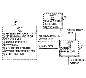
FIG. 2 shows illustrative software interface operations for the drilling
system of FIG.
1. In FIG. 2, the computer system 40 executes software interface 70A, the
computer system
50 executes software interface 70B, and the computer system 60 executes
software interface
70C. The software interfaces 70A-70C are intended to be compatible with each
other to
facilitate and expedite survey operations, survey data corrections, drilling
operations, and
customer review as described herein. For example, the software interfaces 70A-
70C may
employ a communication protocol, handshake, or session scheme that enables
data to be
exchanged between any of the software interfaces 70A-70C. Such a communication
protocol,
13 handshake, or session scheme enables the data received by any of the
software interfaces
70A-70C to be interpreted and applied without user involvement. While user
involvement is
not required, each of the software interfaces 70A-70C typically provides a
user interface that
displays information to a user and/or that accepts user input.
In at least some embodiments, the software interface 70A receives survey data
from a
survey tool (e.g., survey tool 36) and determines a waypoint or borehole path
based on the
survey data. The waypoint or borehole path may be determined with or without
involvement
of a user. Before or after determining the waypoint or borehole path, the
software interface
70A sends the survey data to software interface 70B. The software interface
70B applies
corrections to the survey data received from software interface 70A based on
observatory
data and other correction options. In at least some embodiments, the software
interface 70B
applies corrections based in part on multi-station analysis and/or other
processes. Further, the
software interface 70B may provide a user interface that enables an analyst
and/or survey
manager to review survey data, to review proposed corrections, to modify
correction schemes
or results, and/or to otherwise correct survey data. In some embodiments,
corrections are
applied automatically, but if the survey data or the corrections fall outside
a predetermine
tolerance, an alert is sent to the analyst to review or update proposed
corrections. Once the
survey data has been corrected, the software interface 70B sends the corrected
survey data to
software interface 70A. Further, the software interface 70B may optionally
send the corrected
survey data to software interface 70C. The software interface 70C enables a
customer (or
- 7 -
CA 02919764 2016-01-27
WO 2015/026502 PCT/US2014/049252
anyone with license/permission to view the data) to review, for example,
corrected survey
data and related alerts. Further, the software interface 70C may enable a
customer to submit
project preferences or updates to software interfaces 70A or 70B. When the
software
interface 70A receives corrected survey data from software interface 70B, a
waypoint or
borehole path is automatically updated. Further, the software interface 70A
may enable
manual or automated drilling trajectory adjustments based on the updated
waypoint or
borehole path.
FIG. 3 shows an illustrative process flow 300. In at least some embodiments,
the data
repository 112, process modules 120, and alert generator 124 shown for process
flow 300
3.0 correspond to components of computer system 50, software interface 70B,
and/or other
processing/storage options of a remote monitoring facility. In the process
flow 300, the data
repository 112 receives connection information 102, system information 104,
well
information 106, and survey data 108 as inputs. The connection information 102
may
correspond to one or more database IP addresses, website connection
information, and
Geomagnetic Data Acquisition System (GDAS) connection information. The system
information 104 may correspond to general options, processing options, quality
control
settings (tolerances), alarm intervals, proxy settings, user names,
privileges, and contact
information. The well information 106 may correspond to well data that is
manually entered
or retrieved from a database. Example well data includes, but is not limited
to, units, north
reference, coordinate system, magnetic model, calculation date, well name,
country, district,
job number, customer, company, rig, phone number, well elevation, map
coordinates, and
geographic coordinates. The survey data 108 corresponds to date/time, depth,
Gx, G, G, Bx,
By, 13,, tool azimuth, tool inclination, and/or other parameters received from
a LWD or MWD
tool (e.g., tool 22) via a drilling site computer such as computer system 40.
Further, the survey
data 108 may correspond to passive ranging data. For more information
regarding passive
ranging, reference may be had to U.S. Pat. No. 6,321,456.
In at least some embodiments, the survey data 108 corresponds to new survey
data that
is written to a field database as the survey data is collected by a survey
tool (e.g., survey tool
36) and conveyed to a surface computer (e.g., computer 40) via known telemetry
techniques.
For example, such survey data 108 and other inputs may be transferred to
database 114 of data
repository 112. In some embodiments, the survey data is data-exchanged (DEX'd)
from the
field database to a server database (not shown) periodically or whenever
changes to the field
database are detected. The server database may store active survey data as
well as historical
survey data. The active survey data and/or historical survey data may be
transferred from the
- 8 -
CA 02919764 2016-01-27
WO 2015/026502 PCT/US2014/049252
server database to database 114 of data repository 112 periodically or as new
data is received
by the server database. In at least some embodiments, the data repository 112
may also import
available third-party data (e.g., time/depth data, survey data), which may be
helpful for
applying corrections to survey data as described herein.
The data repository 112 also receives real-time observatory data as input. For
example,
the real-time observatory data may correspond to British Geological Survey
(BGS) data,
Geomagnetic Data Acquisition System (GDAS) data, or local field monitoring
system data.
The BGS data corresponds to interpolated observatory data periodically
retrieved from the BGS
website or server. The GDAS data corresponds to data collected by one or more
magnetic
observatories around the world. One local magnetic observatory is located on
the North Slope
of Alaska and monitors the earth's magnetic disturbance variations for
application to wells
drilled on the North Slope. The GDAS data may be further corrected for secular
variations
(e.g., the BGS Global Geomagnetic Model (BGGM)) and crustal offsets
variations. The
GDAS monitoring service will eventually be replaced by BGS data. The local
field
monitoring system data corresponds to data obtained from a survey tool (e.g.,
survey tool 36)
and/or Proton Precession Magnetometer (PPM) located in close vicinity to a
borehole (e.g.,
borehole 16). The local field monitoring system monitors the disturbance
variation at the
borehole being drilled and applies the disturbance variation directly to the
survey azimuth
recorded by downhole sensors (e.g., sensors/receivers 38 of survey tool 36).
Once the real-
time observatory data is stored in the data repository 112, it becomes
available to the survey
processing threads represented by process modules 120.
In at least some embodiments, calibration correction may be applied to at
least some
of the real-time observatory data input to the data repository 112. For local
field observatories,
the observations recorded by a LWD or MVVD sensor (e.g., sensors 38) need to
be corrected
for the attitude of the sensor and for the affects of temperature on the
sensor readings. The
attitude corrections are measured, for example, by positioning the sensor
horizontally and
pointing in the direction of magnetic east. Typical calibration techniques are
well known in
the industry. The local static dip value is obtained by simply recording the
dip value on the
sensor during a quiet period of magnetic activity. Further, the declination
may be obtained,
for example, by measuring the actual True North direction of the probe using a
theodolite
with GPS functionality. In an example calibration correction, a LWD or MWD
tool (e.g., tool
36) may be placed in an oven (before deployment downhole) to determine sensor
calibration
parameters as a function of temperature. These calibration parameters may be
stored in a
database (e.g., database 114 or 116) and applied to update survey data in
accordance with a
- 9 -
CA 02919764 2016-01-27
WO 2015/026502 PCT/US2014/049252
recorded temperature that existed at the time the survey data was collected.
Such calibration
parameters may additionally or alternatively be loaded into the corresponding
survey tool
(e.g., survey tool 36) tool to enable improved survey data to be collected
from its sensors
(e.g., sensors/receivers 38).
In at least some embodiments, a crustal offset correction is applied to at
least some of
the real-time observatory data input to the data repository 112. The crustal
offset correction is
the accurate measurement of the static magnetic field at the rig site. It may
be obtained either
by taking field observations at the drilling site a survey tool (e.g., survey
tool 36) or by
performing an aeromagnetic survey that is subsequently used to create a model
of the earth's
crustal field in the vicinity of the drill location. Aeromagnetic surveys
provide the ability to
perform downward continuation corrections on the survey data as the well is
drilled. These
downward continuation corrections are the calculated values of the crustal
field below the
earth's surface thereby providing more accurate estimations of the crustal
variations at each
drilling site. Crustal variations remain static during the life of the
drilling project and
therefore only need to be performed once. When using the BGS service, crustal
offset
corrections are provided by BGS in the form of a Waypoint Definition File
(WDF). The
crustal offset corrections, when used, may be automatically applied to survey
data. When
GDAS data is monitored directly, crustal offset corrections may be entered and
applied
separately. In some embodiments, the real-time observatory data is written to
observatory
data tables by separate program threads, and the data tables are forward to
data repository
112.
In at least some embodiments, the data repository 112 stores survey data,
process
parameters used by process modules 120, corrected survey data, and/or other
information in
one or more databases. For example, database 114 may store various types of
data (e.g.,
survey data, observatory data, third-part data, etc.), database 116 stores
process parameters,
and database 118 stores corrected survey data so that every survey may be
reprocessed using
existing or modified parameters at a later date. More specifically, the
database 114 may store
data tables that contain exact copies of the original survey data and
observatory data.
Meanwhile, the database 116 stores process data tables containing all the
information used to
process the survey data including the observatory names and parameters,
waypoint names
and depths, run information, solution configuration information, etc. The
process tables also
contain information about the BGGM, IFR and 11FR parameters applied to each
survey
record as well as all of the multi-station analysis parameters. The database
118 stores
corrected data tables containing a record of the corrected survey data
transmitted back to each
-10-
= CA 02919764 2016-01-27
WO 2015/026502 PCT/1JS2014/049252
drilling site along with supplementary information that is used for post-
analysis, reporting
and plotting functions.
The process modules 120 perform the corrections to the observatory and survey
data
depending on the type of service being provided to the customer. In at least
some
embodiments, the process modules 120 perform various operations including
detecting and
retrieving new data from real-time observatory servers and appending the new
data to the
existing records in the data repository 112. Further, the process modules 120
may routinely
monitor whether new data has been retrieved from real-time observatory servers
and prepare
the new data for processing. Further, the process modules 120 may record the
time at which
the new survey data is written to the data repository 112 so that process
delays may be
detected. Further, the process modules 120 may prepare new survey data for
processing by
searching the database for the associated process parameters (e.g., waypoints,
solutions, etc.).
Further, the process modules 120 may process new survey data by applying
corrections and
calculating the BGGM and IFR dip, Btad, declination values, long collar
azimuth, and short
collar azimuth. Further, the process modules 120 may search the corresponding
observatory
data associated with any unprocessed survey data and defer IIFR correction
until the
appropriate observatory data has been received. Further, the process modules
120 may apply
the associated observatory data to the survey data if the IIFR service is
provided. Further, the
process modules 120 may perform multi-station analysis and corrections to the
processed
survey data. Further, the process modules 120 may determine whether the
processed survey
data falls within predetermined tolerances.
In at least some embodiments, the process modules 120 include a BGGM module
that
applies BGGM secular variation corrections to the survey data. Calculated BGGM
corrections to be applied by the BGGM component may be compared with modeled
BGGM
corrections and checked against predefined tolerances. The process modules 120
also may
include an IFR module that applies IFR corrections to survey data. Calculated
IFR
corrections to be applied by the IFR component may be compared with modeled
IFR
corrections and checked against predefined tolerances. The process modules 120
also may
include an IIFR component applies IIFR corrections to survey data once
corresponding
observatory data becomes available. Calculated IIFR corrections to be applied
by the IIFR
component may be compared with modeled IIFR corrections and checked against
predefined
tolerances.
The process modules 120 also may include a multi-station analysis module that
performs various operations. Further, the multi-station analysis module may
analyze
-11-
= CA 02919764 2016-01-27
WO 2015/026502 PCT/US2014/049252
magnetometer sensor values and ensures that these values within predefined
tolerances. If
any of the measured or calculated values fall outside predefined tolerances
(decision block
122), then a multi-stage alert sequence is initiated by alert generator 124.
For example, the
alert generator 124 may alert a survey analyst 130 with an audible ancUor
visual alarm. If a
resolution has not been reached within a threshold amount of time, the alert
generator 124
alerts the survey analyst 124 with a cell phone text message. If a resolution
has not been
reached within another threshold amount of time, the alert generator 124
alerts a survey
manager 126 with a cell phone text message and email message. In at least some
embodiments, operations of the process modules 120 can be monitored via a user
interface.
3.0 For example, a user interface may enable the survey analyst 124 to
monitor the operations of
the process modules 120 to ensure the operations are performed as expected.
Further, the
multi-station analysis module may enable the survey analyst 124 to modify
solutions as
needed via a user interface.
To summarize, the process modules 120 provide one or more user interfaces and
identify any processes that fall outside of the predetermined tolerances.
Further, the process
modules 120 ensure that the received survey data is processed within a
predefined time limit.
Further, the process modules 120 trigger a sequence to transmit corrected
survey data to each
drilling site and waits for confirmation that the corrected survey data was
received by the
drilling site computer (e.g., computer system 40). Any surveys that fail the
quality control
tolerances are highlighted and examined by the survey analysis 124 and/or the
survey
manager 126. In at least some embodiments, the process modules 120 provide a
user interface
that enables the survey analysis 124 and/or the survey manager 126 to examine
the existing
data and to perform what-if scenarios. Once a new solution has been selected
by the survey
analysis 124 and/or the survey manager 126, the new solution is saved and
applied to all new
surveys. The operations performed by process modules 120 are repeated as
needed.
While the operations of the process modules 120 may apply to many different
surveys, it should be appreciated that some level of customization is
possible. For example,
each drilling project may be prepared by entering observatory information,
well information
106, waypoint information and run information into the data repository 112 or
databases
thereof (e.g., databases 114 and 116). The operations of process modules 120
are dependent
upon the solutions available, and each drilling project may be divided in one
or more
solutions depending on the profile of the well and the drilling environment.
The solution
configuration 128 controls which observatory is referenced, which waypoint is
used and
which services are processed. The solution configuration 128 also controls
which BGGM,
- 12 -
CA 02919764 2016-01-27
WO 2015/026502 PCT/US2014/049252
IFR, IIFR, multi-station analysis, and/or other parameters are used to correct
survey data and
as needed, the survey manager 126 may adjust the solution configuration 128.
FIG. 4 shows an illustrative drilling method 400. The method 400 may be
performed,
for example, by a drilling site computer such as computer system 40. In method
400, survey
data is collected at a drilling site (block 402). At block 404, a waypoint or
borehole path is
determined based on the survey data. At block 406, the survey data is sent to
a remote
monitoring facility that applies corrections to the survey data. At block 408,
the corrected
survey data is received. At block 410, the waypoint or borehole path is
automatically updated
based on the corrected survey data. At block 412, a drilling trajectory is
adjusted manually or
io automatically based at least in part on the updated waypoint or borehole
path. Alternatively,
if no corrections are needed (i.e., the survey data is within specified
limits), blocks 408, 410,
and 412 may be omitted. Instead, a notification to the effect that survey data
corrections are
not needed may be received. In such case, drilling adjustments are similarly
not needed.
In at least some embodiments, the above-described methods and systems are also
configured to improve well survey performance, for example, by linking errors
identified by
a central facility performing survey management (e.g., using multi-station
analysis or other
techniques) with an instrument performance model (IPM) of a well survey
instrument (e.g., a
sensor 38 of survey tool 36). For example, the remote computer system 50 may
perform
error analysis to identify errors associated with operating a well survey
instrument in a
magnetic environment (e.g., borehole 16). As described herein, the transfer of
information
between the computer system 40 and the remote computer system 50 for such
error analysis
may be automated (e.g., error analysis results or corrections can be provided
with the alerts or
corrected survey data described herein). The error analysis can identify, for
example, multiple
error sources of measured well survey data, errors (e.g., including error
limits or ranges) of
survey data due to the multiple error sources, reliability of any corrections
to the survey data,
or any other information. The error analysis results or correction information
can be received
from a remote computer system (e.g., remote computer system 50) and processed
automatically by a drilling site computer system (e.g., computer system 40) as
described
herein to update a waypoint or borehole path for drilling operations, and/or
to perform other
operations.
In at least some embodiments, the errors can be determined for a specific well
profile
and location; and the error limits or quality control (QC) limits can vary as
a function of
wellbore location and attitude. For example, a sensitivity analysis can be
performed to
determine the accuracy with which cross-axial shielding and axial magnetic
interference can
- 13 -
= CA 02919764 2016-01-27
WO 2015/026502 PCT/US2014/049252
be calculated for a well profile and location. The information identified by
the error analysis
can be linked to an IPM, for example, to select an appropriate IPM with
technical
specifications suitable for the identified errors, and to determine whether
the selected IPM is
correctly assigned. In this manner, an improved check on survey quality can be
achieved.
In at least some embodiments, such error analysis can be applied to any
borehole or
well system where the survey information about the wellbore's position is
derived from
mutually orthogonal measurements of the instantaneous gravity and magnetic
field vectors
(e.g., with one of the measuring axes aligned along the principal or "hole"
axis of the
wellbore), and where an IPM is used to calculate the magnitude of positional
uncertainty
associated with these measurements. Such error analysis can be performed
during a survey
program design stage to determine (e.g., for each hole section) which error
sources can
reliably be calculated using single axis and multi-station analysis correction
techniques. By
linking the QC limits to an IPM used in the well planning stage, confidence
that the survey
lies within a calculated uncertainty region (e.g., an ellipse of uncertainty)
can be improved. In
at least some embodiments, the error analysis can also be used during a survey
management
stage (e.g., either during the data acquisition phase, with historical data,
or a combination
thereof) for each bit run as a quality check on the single axis calculated
values of axial
magnetic interference and the calculated values for cross-axial shielding and
axial magnetic
interference. In some instances, potential directional problems could be
revealed during the
planning stage. Linking the quality assurance (QA) checks to the IPM would
provide a more
reliable check on the required survey accuracy for each specific well.
FIG. 5 shows an error analysis method 500 for improving a well survey
performance.
As an example, the method 500 can be used to improve the survey performance of
drilling
system 100. All or part of the method 500 may be performed by computer system
50 and/or
other computer systems of a remote facility. In at least some embodiments,
some or all of the
method 500 can be implemented and incorporated into MSA software or other
module(s) of
process modules 120 (see FIG 3) to expand and enhance the capabilities of a
central facility
performing survey management. The method 500, individual operations of the
method 500,
or groups of operations may be iterated or performed in parallel, in series,
or in another
manner. In some cases, the method 500 may include the same, additional, fewer,
or different
operations performed in the same or a different order.
In some embodiments, some or all of the operations in the method 500 are
executed
during a survey program design or plan stage. Additionally or alternatively,
some or all of
the operations in the method 500 are executed in real-time during a survey
management
- 14 -
CA 02919764 2016-01-27
WO 2015/026502 PCT/US2014/049252
stage. For example, the operations of method 500 may be performed during a
drilling
process, or during another type of well system activity or phase in which
measurement data is
acquired and stored. In such case, the operations of method 500 can be
performed in response
to newly acquired data (e.g., from a sensor 38 of tool 36) without substantial
delay. Further,
the operations of method 500 can be performed in real-time while additional
data is being
collected (e.g., from surveying, drilling, or other activities). In at least
some embodiments,
operations of the method 500 involve receiving an input and producing an
output during a
treatment or other downhole operation, where the output is made available to a
user (e.g.,
survey analyst 130) within a time frame that allows the user to respond to the
output, for
example, by modifying the survey program, the well plan, or another treatment.
At block 502, well survey data is received. The well survey data can include,
for
example, well plan data, one or more IPMs, and survey management data (e.g.,
data
measured from a well survey instrument. The well survey data may additionally
or
alternatively include data processed by multi-station analysis software to
account for a local
magnetic environment at a wellbore location. Further, in at least some
embodiments, the well
survey data can include projected or hypothetical data, real-time data,
historical data, or a
combination thereof. Further, in at least some embodiments, some of the well
survey data is
time-dependent, location-dependent, or environment-dependent. For example, the
well plan
data, the IPM, and the measurement data can include data associated with
different survey
stations, drilling stages, wellbore locations, or subterranean environments.
Further, additional
or different data can be obtained and used for later processing.
The well plan data can include any data or information describes a well
trajectory to
be followed to take a well successfully from its surface position to the end
of the well
trajectory. For example, the well plan can include designed or projected
wellbore location,
depth, distance, inclination, azimuth, or other information that describe a
wellbore position
and attitude. Based on factors such as an expected use of a well (e.g.,
observation,
production, injection, or multi-purpose well), parameters (e.g., production
parameters,
completion requirements, well dimensions, location), an expected life of the
well, and
conditions of the geological target (e.g., the subterranean reservoir) to be
reached by the well,
and other factors, the well plan can outline well objectives to be achieved
during well drilling
and well use.
The IPM (also called a toolcode) can include any information or modules that
can be
used to simulate a well surveying and planning tool or instrument. For
example, an IPM can
include a model simulating the performance of the survey tool and the way it
was run and
- 15 -
CA 02919764 2016-01-27
WO 2015/026502 PCT/US2014/049252
processed. In some instances, an IPM can include technical specifications of
the survey
accuracy, mathematical description of the expected errors, or any other
information. For
example, an IPM can include mathematical algorithms and constants for
determining
measurement uncertainty for a well survey instrument under specific downhole
conditions.
Further, the IPM can specify survey accuracy and provide a confidence
indication of whether
an actual well trajectory will match the predicted or planned trajectory
(e.g., whether the
actual wellbore location will hit the target location).
In at least some embodiments, the IPM can be specific to a particular survey
instrument, a particular survey station, or a specific magnetic or
gravitational environment.
3.0 Further, a survey instrument may have multiple IPMs, for example,
depending on the
magnetic, gravitational or other subterranean environment to which the survey
instrument is
applied. Each IPM may describe how the survey instrument performs downhole in
the
corresponding subterranean environment. In some instances, IPM can be provided
by
instrument vendor, service company or operating company.
The well survey data may additionally or alternatively include local magnetic
vector
estimates, error estimates for selected magnetic model, accelerometer bias and
scale factors,
magnetometer bias and scale factors, magnetic shielding magnitude, statistical
confidence
levels for the analysis, residual errors from the thermal models and rotation
check shot data
obtained during the tool calibration process, or other information. In at
least embodiments,
local magnetic vector estimates is obtained from MWD Geomagnetic Models (e.g.,
BGGM,
High Definition Geomagnetic Model (HDGM), IFR, or IIFR data). The
accelerometer bias
and scale factors (for accelerometers and magnetometer) are determined using
routine
calibration techniques. In at least some embodiments, errors associated with
such bias and
scale factors are within an error budget defined by the Industry Steering
Committee on
Wellbore Survey Accuracy (ISCWSA). However, it should be appreciated that
survey
management data can be obtained from additional or different models and
techniques.
At block 504, an error analysis can be performed to identify errors associated
with
operating the well survey instrument in the magnetic environment at a wellbore
location (e.g.,
borehole 16). In at least some embodiments, the error analysis can be
performed based on the
well survey data including, for example, well plan data and survey management
data. Further,
the errors associated with the well survey can be calculated for a particular
well location, well
attitude, accuracy of the local magnetic field parameters, or another factor.
In some instances,
the error analysis can include a sensitivity analysis to determine the
accuracy of the
calculated cross-axial and axial systematic errors for the well plan. As an
example, limits of
-16-
= CA 02919764 2016-01-27
WO 2015/026502 PCT/11S2014/049252
errors in the dip angle and the total magnetic field kw-al can be calculated
as a function of
well location, well attitude, and accuracy of the local magnetic field
parameters. In some
instances, the errors in dip and Btot.õ1 can be determined based on different
error sources
including, for example, axial magnetic interference, cross-axial magnetic
shielding, errors
from magnetometers and accelerometers, or other types of errors. In some
embodiments, the
errors in dip and Bt.õta/ can be determined from the following equations, or
in another
manner.
P = cosy * sine * coszp siny cose (1)
cosy * case ¨ siny * sine * costp (2)
LONG COLLAR AZIMUTH
Axial Magnetic Interference
ODip(5BZI) = * ¨18D * 6Bz (3)
71:
61305BZ) = P 6Bz (4)
Cross-axial magnetic shielding
Sxv 130
SDEKSxy) =¨P * (5)
100 7T
SXV
8BOSX:0 = Be * (1 _p2) * (6)
Magnetometer Errors
$513."7,-.
5DiP.(6Rzyz) = * (7)
6Bt(6141,) =
.syz (8)
Accelerometer Errors
Igo
6Dip(6G) = ¨ (9)
SHORT COLLAR AZIMUTH
K = 1 ¨ sin20 * sin. 2 (10)
Theoretical Dipe Error
P=1=Q ,õ 100
Spipc(Srie) obo * e * (11)
613tc(88e) = (¨F2 ¨ 1) * 6Be
(12)
.K
-17-
CA 02919764 2016-01-27
WO 2015/026502 PCPUS2014/049252
Cross-axial shielding
¨PQ Saw 150
&Dine (51: y) = ____________ * ¨
(13)
K 100 TT,
P:3\ Syv
oBtC(SXy) = (1 ¨ ¨) * Be * ______ "
(14)
. 100
Magnetometer errors
P 180
8Dipc(Sfiry,) = * +5B,õy, (15)
7,7
,58 t = Q._ * 613,7,
(16)
K
Accelerometer errors
-% P2 180
6Dipc(6Gxy)z =¨K *
(17)
oBtC(6Gxyz) = Be.P(2
(18)
In the above equations, Be represents local magnetic field strength; y
represents local
magnetic dip angle; Bn represents horizontal magnetic field; e represents
inclination; W
represents magnetic azimuth; 6Dip represents calculated dip angle error; 6Bt
represents
calculated Bt,tal error; oDipc represents error in calculated dip angle using
short collar
correction (SCC) azimuth; 6Btc represents error in calculated Btotõz using SCC
azimuth;
6Bz represents axial magnetic interference; Sxy represents cross-axial
magnetic shielding
represents magnetometer errors; 6Gxy, represents accelerometer errors; 6Dipe
represents error in local dip angle; and 8Be represents error in local
magnetic field.
Additional or different errors of well survey parameters can be determined.
In at least some embodiments, the error limit can be determined based on the
multiple
errors calculated for different error sources, for example, by identifying the
maximum error
value among the multiple errors. Further, the error limit can vary as a
function of wellbore
location and attitude and can change for each survey station. Further, the
error limit can be
used as the quality control or quality assurance (QC or QA) metric and can be
linked to a
specific 1PM to provide an improved check on survey quality. Further, an
appropriate IPM for
the well survey by the well survey instrument can be selected based on the
error analysis. For
example, the IPM can be selected such that the errors identified by the error
analysis satisfy
specifications of the IPM.
-18-
CA 02919764 2016-01-27
WO 2015/026502 PCT/US2014/049252
At decision block 506, a determination is made regarding whether the errors
satisfy a
selected IPM. In at least some embodiments, the determination can be based on
a comparison
between the error limit and a well survey accuracy specified by the IPM. The
accuracy
specification of the IPM can include, for example, a range (e.g., associated
with a confidence
interval), an upper limit, a lower limit, or another type of information
indicating the expected
accuracy (or uncertainty) of operating the well survey instrument in a
subterranean
environment. In some instances, if the errors satisfy the IPM (e.g., the error
limit falls within
an accuracy range specified by the IPM, the maximum error is less than or
equal to the upper
uncertainty limit specified by the IPM, etc.), the IPM can be assigned to the
survey program
at block 508, for example, for the corresponding section of the well plan.
In at least some embodiments, if the errors do not satisfy the IPM (e.g., the
maximum
error calculated based on the error analysis of block 504 exceeds the accuracy
specification of
the IPM), techniques for manipulating or otherwise processing the well survey
data can be
performed to select an 1PM such that the errors satisfies the IPM at block
510. Techniques for
is processing the well survey data can include, for example, improving the
accuracy of the local
magnetic field parameters or other survey parameters, revising the well plan,
changing the
IPM, or other techniques.
In at least some embodiments, the accuracy of the local magnetic field
parameters can
be improved, for example, by using more accurate and advanced survey
instrument or survey
management models and techniques. For instance, the local magnetic field
parameters can be
obtained from IIRF instead of BGGM since typically IIRF provides more accurate
local
magnetic field parameter values than BGGM. As another example, the errors of
magnetometers and accelerometers can be reduced, for example, by using higher-
quality
magnetometers and accelerometers.
As needed, a well plan can be revised, for example, to change the well
profile,
waypoints, borehole path, or trajectory. For instance, a well plan can be
changed to account
for different gravitational or magnetic environments. As an example, gravity
environments
are generally consistent (changing as a function of depth) and can be
accounted for using
downward continuation modeling. Meanwhile, known magnetic or geological
problems can
be accounted for based on historical data.
Further, IPMs can be changed. For example, another IPM with a less stringent
accuracy specification (e.g., with a lower confidence level or interval) can
be selected so that
the identified error limit fits within the accuracy specification of the new
IPM. In some
instances, an IPM with a more stringent accuracy specification (e.g., with a
higher confidence
-19-
CA 02919764 2016-01-27
WO 2015/026502 PCT/11S2014/049252
level or interval) may be selected if the identified upper error limit is much
lower than the
accuracy specification of the current IPM. In this case, the errors associate
with operating the
survey instrument can be more tightly fitted into the accuracy specification
of the IPM and
the IPM can be more accurate in describing the performance of the survey
instrument.
Additional or different techniques can be used for the method 500. For
example, after
performing one or more operations at block 510, the method 500 may return to
block 502
based on a changed well plan, IPM, or other information. The method 500 may be
performed
in an iterative manner until, for example, an appropriate IPM is selected such
that the errors
associated with the well survey instrument are compatible with the IPM.
Embodiments disclosed herein include:
A: A drilling method that comprises collecting survey data at a drilling site,
determining a waypoint or borehole path based on the survey data, sending the
survey data to
a remote monitoring facility that applies corrections to the survey data,
receiving the
corrected survey data, and automatically updating the waypoint or borehole
path based on the
corrected survey data or a related correction message.
B: A drilling system that comprises a survey tool that collects survey data.
The system
also comprises at least one drilling site computer configured to receive the
survey data from
the survey tool, to determine a waypoint or borehole path based on the survey
data, and to
send the survey data to a remote monitoring facility. The at least one
drilling site computer is
configured to automatically update the waypoint or borehole path based on
corrected survey
data or a related correction message received from the remote monitoring
facility.
C: A system that comprises a first computer that determines a waypoint or
borehole
path based on survey data collected by a survey tool, and a second computer in
communication with the first computer. The second computer applies a
correction to the
survey data based on at least one of observatory data, multi-station analysis,
and an
instrument performance model (1PM). The first computer automatically updates
the waypoint
or borehole path based on the corrected survey data or a related correction
message.
Each of the embodiments, A, B, and C, may have one or more of the following
additional elements in any combination. Element 1: further comprising
displaying an update
acceptance prompt or alert notification related to the updated waypoint or
borehole path.
Element 2: the update acceptance prompt or alert notification includes at
least some of the
corrected survey data. Element 3: the update acceptance prompt or alert
notification includes
a plurality of response options. Element 4: further comprising displaying the
updated
waypoint or borehole path. Element 5: further comprising automatically
adjusting a drilling
- 20 -
CA 02919764 2016-01-27
WO 2015/026502 PCT/US2014/049252
trajectory based at least in part on the updated waypoint or borehole path.
Element 6: further
comprising manually adjusting a drilling trajectory based at least in part on
the updated
waypoint or borehole path. Element 7: the survey data comprises time, depth,
inclination, and
azimuth data, magnetic field components, and gravitational field components.
Element 8: the
survey data comprises passive ranging data. Element 9: the corrections to the
survey data are
based at least at least one of observatory data, multi-station analysis, and
an instrument
performance model (IPM). Element 10: the related correction message includes a
survey tool
replacement indicator.
Element 11: the at least one drilling site computer is configured to display
an update
1.0 acceptance prompt or alert notification related to the updated waypoint
or borehole path.
Element 12: the update acceptance prompt or alert notification includes a
plurality of
response options. Element 13: the at least one drilling site computer displays
the updated
waypoint or borehole path. Element 14: the at least one drilling site computer
provides a
drilling control interface that enables a drilling trajectory to be
automatically adjusted based
at least in part on the updated waypoint or borehole path. Element 15: the at
least one drilling
site computer provides a drilling control interface that enables a drilling
trajectory to be
manually adjusted based at least in part on the updated waypoint or borehole
path. Element
16: the survey data comprises magnetic field components and gravitational
field components.
Element 17: further comprising at least one computer at the remote monitoring
facility
configured to apply at least one of a BGGM correction, an IFR correction, an
IIFR correction,
and an instrument performance model (IPM) correction to the survey data.
Element 18:
further comprising at least one computer at the remote monitoring facility
configured to apply
a correction to the survey data based on multi-station analysis.
Element 19: further comprising a third computer in communication with the
second
computer, wherein the third computer receives alerts related to the corrected
survey data.
Element 20: the third computer comprises a mobile computing device.
Numerous variations and modifications will become apparent to those skilled in
the
art once the above disclosure is fully appreciated. For example, it should be
appreciated that
corrected survey data may be sent from a remote monitoring facility to
drilling site computer
and/or customer computers in an automated manner once corrections are
approved/applied. It
is intended that the following claims be interpreted to embrace all such
variations and
modifications.
-21-