Note: Descriptions are shown in the official language in which they were submitted.
81798093
MULTI-DIMENSIONAL SEISMIC SENSOR ARRAY
TECHNICAL FIELD
The present application relates to marine seismic surveys and multi-
dimensional
sensor arrays.
BACKGROUND
The following descriptions and examples do not constitute an admission as
prior art
by virtue of their inclusion within this section.
Seismic exploration involves surveying subterranean geological formations for
hydrocarbon deposits. A seismic survey may involve deploying seismic source(s)
and seismic sensors at predetermined locations. The sources generate seismic
waves, which propagate into the geological formations creating pressure
changes
and vibrations along their way. Changes in elastic properties of the
geological
formation scatter the seismic waves, changing their direction of propagation
and
other properties. Part of the energy emitted by the sources reaches the
seismic
sensors. Some seismic sensors are sensitive to pressure changes (hydrophones),
others to particle motion (e.g., geophones, accelerometers), and industrial
surveys
may deploy one type of sensors or both. In response to the detected seismic
events,
the sensors generate electrical signals to produce seismic data. Analysis of
the
seismic data can then indicate the presence or absence of probable locations
of
hydrocarbon deposits.
Some surveys include long streamers (e.g., as long as 8 kilometers or more),
and
may have eight or more streamers towed adjacent to one another. Vessels that
tow
1
Date Recue/Date Received 2021-07-19
81798093
those streamers are generally large and 100 foot long or more and have a
substantial crew.
With large vessels of this character, entanglement or other negative
interaction with
obstacles may be problematic, and can in some cases prevent surveys from being
performed
in certain areas. Also, cost of operation can be relevant.
Accordingly, the present application relates to smaller vessels that can
provide certain
advantages over those performed by large vessels both in cost of operation and
performance.
Thus, the present application relates to a number of combinations of embodied
features
relating to unmanned vessels and sensors related thereto.
The preceding description is meant to help the understanding of one skilled in
the art and is
not meant in any way to unduly limit the scope of any present or subsequent
related claims of
the present application.
SUMMARY
The following is a description of various combinations of embodied features
and is meant in
no way to unduly limit any present or future related claim in the present or
subsequent
related applications.
According to an aspect of the present disclosure, there is provided a system,
comprising: an
unmanned marine vessel having a hull; a multi-dimensional seismic sensor array
coupled
with the hull, wherein the multi-dimensional seismic sensor array is
configured to acquire
seismic survey data in multiple directions; wherein the unmanned marine vessel
comprises a
power source configured to drive and provide propulsion to the unmanned marine
vessel;
and an umbilical cord for coupling the multi-dimensional seismic sensor array
with the hull of
the unmanned marine vessel, wherein the umbilical cord provides electrical
communication
between the unmanned marine vessel and the multi-dimensional seismic sensor
array;
wherein the system further comprises a sub component disposed between the
umbilical cord
and the multi-dimensional seismic sensor array, a force decoupling mechanism
disposed
between the sub component and the multi-dimensional seismic sensor array;
wherein the
multi-dimensional seismic sensor array comprises multiple seismic streamers
coupled
together with multiple collars comprising a first collar coupled to a first
end of the seismic
streamers and a second collar coupled to a second end of the seismic streamers
that is
2
Date Recue/Date Received 2021-07-19
81798093
opposite the first end; and wherein a buoyancy of the multiple collars is
configured to
maintain the multi-dimensional seismic sensor array at a particular depth in a
water column.
According to another aspect of the present disclosure, there is provided a
device, comprising:
a multi-dimensional seismic sensor array configured for coupling to an
unmanned marine
vessel and configured for floating beneath the unmanned marine vessel at a pre-
determined
depth, the multi-dimensional seismic sensor array configured to acquire
seismic survey data
in multiple directions, the multidimensional seismic sensor array having at
least three seismic
streamers arranged in a triangular prism shape; wherein the multi-dimensional
seismic
sensor array comprises multiple seismic streamers coupled together with
multiple collars
comprising a first collar coupled to a first end of the seismic streamers and
a second collar
coupled to a second end of the seismic streamers that is opposite the first
end, and wherein
a buoyancy of the multiple collars is configured to maintain the multi-
dimensional seismic
sensor array at the pre-determined depth beneath the unmanned marine vessel.
According to another aspect of the present disclosure, there is provided a
method of
performing a seismic survey, comprising: locating in water an unmanned seismic
survey
vessel having coupled thereto a multidimensional seismic sensor array
comprising at least
three parallel streamers; activating a seismic source and detecting
reverberations of that
source with the seismic sensor array and recording resulting data; wherein a
force
decoupling mechanism is disposed between a sub component and the multi-
dimensional
seismic sensor array; wherein the multi-dimensional seismic sensor array
comprises multiple
seismic streamers coupled together with multiple collars comprising a first
collar coupled to a
first end of the seismic streamers and a second collar coupled to a second end
of the seismic
streamers that is opposite the first end; and wherein a buoyancy of the
multiple collars is
configured to maintain the multi-dimensional seismic sensor array at a
particular depth in a
water column.
According to various combination of embodied features, a system can include an
unmanned
marine vessel having a hull; a multi-dimensional seismic sensor array coupled
with the hull,
wherein the multi-dimensional seismic sensor array is configured to acquire
seismic survey
data in multiple directions; wherein the unmanned marine vessel comprises a
power source
configured to drive and provide propulsion to the unmanned marine vessel; and
an umbilical
cord for coupling the multi-dimensional seismic sensor array with the hull of
the unmanned
2a
Date Recue/Date Received 2021-07-19
81798093
marine vessel, wherein the umbilical provides electrical communication between
the
unmanned marine vessel and the multi-dimensional seismic sensor array.
According to various combination of embodied features, a device includes a
multi-
dimensional seismic sensor array configured for coupling with an unmanned
marine vessel
and configured for floating beneath the unmanned marine vessel at a
predetermined depth,
the multi-dimensional seismic sensor array configured to acquire
2b
Date Recue/Date Received 2021-07-19
CA 02935752 2016-06-30
WO 2015/113031
PCT/US2015/013038
seismic survey data in multiple directions, the multi-dimensional seismic
sensor array
having at least three seismic streamers arranged in a triangular prism shape.
According to various combination of embodied features, the a method of
performing
a seismic survey, includes locating in water an unmanned seismic survey vessel
having coupled thereto a multidimensional sensor array comprising at least
three
parallel streamers; activating a seismic source and detecting reverberations
of that
source with the sensor array and recording resulting data.
The above referenced summary section is provided to introduce a selection of
concepts in a simplified form that is further described in the detailed
description
section herein below.
The summary is not intended to identify key features or essential features of
claimed
subject matter, nor is it intended to be used to limit the scope of the
claimed subject
matter. The claimed subject matter is not limited to implementations that
solve any
or all disadvantages noted in any part of this disclosure.
BRIEF DESCRIPTION OF THE DRAWINGS
Implementations of various techniques will hereafter be described with
reference to
the accompanying drawings. It should be
understood, however, that the
accompanying drawings illustrate only the various implementations described
herein
and are not meant to limit the scope of various techniques described herein.
Figures 1A-1B illustrate diagrams of systems for acquiring seismic survey data
using
a multi-dimensional seismic sensor array coupled to an unmanned marine vessel
in
accordance with implementations of various techniques described herein.
Figure 2 illustrates a diagram of a system for acquiring seismic survey data
using a
multi-dimensional seismic sensor array coupled to an unmanned marine vessel in
accordance with implementations of various techniques described herein.
Figures 3-4 illustrate various diagrams of devices for acquiring seismic
survey data
using a multi-dimensional seismic sensor array coupled to an unmanned marine
vessel in accordance with implementations of various techniques described
herein.
Figure 5 illustrates a computing system in accordance with implementations of
various techniques described herein.
3
CA 02935752 2016-06-30
WO 2015/113031
PCT/US2015/013038
DETAILED DESCRIPTION
The discussion below is directed to certain implementations. It is to be
understood
that the discussion below is only for the purpose of enabling a person with
ordinary
skill in the art to make and use any subject matter defined now or later by
the patent
"claims" found in any issued patent herein.
It is specifically intended that the claimed combinations of features not be
limited to
the implementations and illustrations contained herein, but include modified
forms of
those implementations including portions of the implementations and
combinations
of elements of different implementations as come within the scope of the
following
claims. It should be appreciated that in the development of any such actual
implementation, as in any engineering or design project, numerous
implementation-
specific decisions must be made to achieve the developers' specific goals,
such as
compliance with system-related and business related constraints, which may
vary
from one implementation to another. Moreover, it should be appreciated that
such a
development effort might be complex and time consuming, but would nevertheless
be a routine undertaking of design, fabrication, and manufacture for those of
ordinary
skill having the benefit of this disclosure. Nothing in this application is
considered
critical or essential to the claimed invention unless explicitly indicated as
being
"critical" or "essential."
It will also be understood that, although the terms first, second, etc. may be
used
herein to describe various elements, these elements should not be limited by
these
terms. These terms are only used to distinguish one element from another. For
example, a first object or step could be termed a second object or step, and,
similarly, a second object or step could be termed a first object or step,
without
departing from the scope of the invention. The first object or step, and the
second
object or step, are both objects or steps, respectively, but they are not to
be
considered a same object or step.
The following paragraphs provide various techniques for acquiring seismic
survey
data using a multi-dimensional seismic sensor array coupled to an unmanned
marine
vessel, vehicle, device, etc., which will now be described in more detail with
reference to Figures 1-5.
4
CA 02935752 2016-06-30
WO 2015/113031
PCT/US2015/013038
Marine surveys may be performed in various marine environments. In a marine
survey, unmanned marine vessels, such as autonomously operated vehicles (A0Vs)
or remotely operated vehicles (ROVs), may be used to gather seismic data from
one
or more seismic sensors. These seismic sensors may be attached to vertical
seismic streamers deployed from the unmanned marine vessels, which may allow
for
more effective removal of ghost signals and measurement of propagation speed
when compared with more conventional horizontal streamers towed by larger
vessels.
Figures 1A-1B illustrate various schematic diagrams of systems 100A, 100B for
acquiring seismic survey data in accordance with implementations of techniques
described herein. In particular, Figure 1A illustrates a diagram of a system
100A for
acquiring seismic survey data using a multi-dimensional seismic sensor array
12
coupled to an unmanned marine vessel 10, and Figure 1B illustrates another
diagram of a system 100B for coupling the multi-dimensional seismic sensor
array
12 to the unmanned marine vessel 10 with a force decoupling mechanism 17, in
accordance with implementations of various techniques described herein.
The system 100 may include at least one unmanned marine vessel 10 that may be
adapted to descend through a water column or may be adapted for movement on a
sea surface via a thrust or propulsion mechanism. The unmanned marine vessel
10
may include an autonomously operating vehicle (AOV) or a remotely operating
vehicle (ROV) maneuvering on the sea surface, such as a wave glider or a
hybrid
water vehicle. In some examples, the wave glider may be configured to harness
wave energy to impart motion to the wave glider. In some examples, the hybrid
water vehicle may be configured to combine mechanical propulsion methods with
energy harvesting principles, such as the energy harvesting principles used by
wave
gliders. In some examples, the unmanned marine vessel 10 may take the form of
one or more other types of marine vessels, such as a diving wave glider, a
submarine unmanned marine vessel, a sail buoy, or any other implementation
known
to those skilled in the art.
The unmanned marine vessel 10 may be used for seismic surveying and may
include a multi-dimensional seismic sensor array 12. In various
implementations, the
term multi-dimensional may refer to two-dimensional (2D), three-dimensional
(3D), or
more than three dimensional, depending on specific implementations. Further,
in
CA 02935752 2016-06-30
WO 2015/113031
PCT/US2015/013038
some implementations, the multi-dimensional seismic sensor array 12 may be
referred to as a seismic sensor package having multiple seismic sensors as
described herein.
In reference to Figure 1A, the multi-dimensional seismic sensor array 12 may
be
disposed on a streamer 14 coupled to the unmanned marine vessel 10. The
streamer 14 may descend in a generally vertical direction from the unmanned
marine
vessel 10 into a water column. In one implementation, the streamer 14 may
descend to a depth below the sea surface. For example, the streamer 14 may
descend 10 meters or greater below the sea surface.
In various implementations, the multi-dimensional seismic sensor array 12 may
be
coupled to a hull of the unmanned marine vessel 10 via an umbilical cord or a
streamer 14. The multi-dimensional seismic sensor array 12 may be configured
to
acquire seismic survey data and calculate pressure gradients in multiple
directions.
In some examples, the multiple directions may include horizontal and vertical
directions. In some other examples, the multiple directions may include any or
all of
x-coordinate, y-coordinate, and z-coordinate directions.
The multi-dimensional seismic sensor array 12 may include various sensor
including
pressure sensors, particle motion sensors, and/or multi-component seismic
sensors.
For example, in reference to multi-component seismic sensors, the multi-
dimensional
seismic sensor array 12 may be configured to detect a pressure wavefield and
at
least one component of a particle motion that is associated with acoustic
signals that
may be proximate to the multi-component seismic sensor. Further, examples of
particle motion sensors include one or more components of a particle
displacement,
one or more components (inline (x), crossline (y) and vertical (z) components)
of a
particle velocity and one or more components of a particle acceleration.
In various implementations, the multi-component seismic sensors may include
one
or more geophones, hydrophones, inclinometers, particle displacement sensors,
optical sensors, particle velocity sensors, accelerometers, pressure gradient
sensors, or combinations thereof. According to some embodiments, a particular
multi-component seismic sensor may include three orthogonally-aligned
accelerometers (e.g., three-component micro-electro-mechanical system (MEMS)
accelerometer) to measure three corresponding orthogonal components of
particle
6
81798093
velocity and/or acceleration near the seismic sensor.
According to some
embodiments, the MEMS-based accelerometer may be a capacitive MEMS-based
sensor of the type described in commonly assigned co-pending U.S. Patent
Application No. 12/268,064, US Patent No.
8,104,346. In some
implementations, one or more hydrophones configured for measuring pressure may
be used in combination with the three-component MEMS described herein.
The multi-component seismic sensor may be implemented as a single device or as
a
plurality of devices. A particular multi-component seismic sensor may also
include
pressure gradient sensors, which constitute another type of particle motion
sensors.
Each pressure gradient sensor measures the change in the pressure wavefield at
a
particular point with respect to a particular direction. For example, one of
the
pressure gradient sensors may acquire seismic data indicative of, at a
particular
point, the partial derivative of the pressure wavefield with respect to the
crossline
direction, and another one of the pressure gradient sensors may acquire, at a
particular point, seismic data indicative of the pressure data with respect to
the inline
direction.
The unmanned marine vessel 10 may be deployed to a survey area for seismic
surveying. Where the unmanned marine vessel 10 takes the form of an AOV, the
unmanned marine vessel 10 may be deployed to a survey area specified on a
navigation map. The unmanned marine vessel 10 may automatically make
corrections, if the unmanned marine vessel 10 veers off-course. Where the
unmanned marine vessel 10 takes the form of a ROV, the unmanned marine vessel
may be deployed to a survey area using remote operation of the unmanned
marine vessel's rudder and/or thrust mechanism.
After deploying the unmanned marine vessel 10 to the survey area, a seismic
source
18 may be activated to generate acoustic waves 20 that propagate through an
ocean
bottom surface 22 and into strata 24, 26 beneath the ocean bottom surface. The
seismic source 18 may be located on another unmanned marine vessel 11, as
shown in Figure 1A, or more conventional source deployments may be used, such
as the use of dedicated source vessels. The seismic source 18 may be a
conventional air gun, marine vibrator, or non-traditional environmentally
friendly
source. The seismic source may also include drilling induced acoustic pressure
7
Date Recue/Date Received 2021-07-19
CA 02935752 2016-06-30
WO 2015/113031
PCT/US2015/013038
waves, passive seismic noise, or production induced acoustic pressure waves,
such
as those which may result from water or gas injections, or combinations
thereof.
Acoustic signals 20 may be reflected from various subterranean geological
formations, such as formation 28 depicted in Figure 1A. The incident acoustic
signals 20 produce corresponding reflected acoustic signals, or pressure waves
30,
which are sensed by the multi-dimensional seismic sensor array 12. The
unmanned
marine vessel 10 may record seismic data from over one hundred seismic
sensors.
The multi-dimensional seismic sensor array 12 may generate signals called
"traces,"
which indicate the acquired measurements of the pressure wavefield and
particle
motion if the sensors include particle motion sensors. The traces are recorded
and
may be passed to a data acquisition system 32 disposed on the unmanned marine
vessel 10. The data acquisition system 32 may include a digitizer, a computer
system, and a storage system for storing seismic data acquired during the
survey.
The storage system may include memory, such as a hard disk drive. In one
implementation, the seismic data may be recorded continuously over days or
months
at a time. In another
implementation, the seismic data may be recorded
intermittently, such as after each detonation of the seismic source 1 8.
The unmanned marine vessel 10 may include an onboard communication unit 34,
which may communicate with a base station located onshore or at sea, such as
on a
rig or vessel. The communication unit 34 may be used to transmit data and
information associated with the unmanned marine vessel 10, including position,
quality control parameters, time information, and seismic data. The
communication
unit 34 may send or receive commands particular to the seismic survey. The
unmanned marine vessel 10 may include a power source (e.g., batteries, motor,
propeller, etc.) configured to drive and provide propulsion to the unmanned
marine
vessel 10. In some examples, the unmanned marine vessel 10 may be powered by
batteries, which may be recharged by solar panels disposed on the top of the
unmanned marine vessel 10.
As mentioned previously and as illustrated in Figure 1A, the streamer 14 may
descend in a generally vertical direction from the unmanned marine vessel 10
into
the water column. The length of the streamer 14 may vary from less than one
meter
to over one kilometer. In some examples, a sub component 16 may be disposed
8
CA 02935752 2016-06-30
WO 2015/113031
PCT/US2015/013038
between the umbilical cord or streamer 14 and the multi-dimensional seismic
sensor
array 12. The sub
component 16 may be configured to provide electrical
communication between the unmanned marine vessel 10 and the multi-dimensional
seismic sensor array 12. In some examples, the sub component 16 may be
employed as a fairing to reduce cross-flow noise due to currents and drag
forces.
Further, in some examples, accelerometers (not shown) capable of measuring a
gravity vector may be used to measure a tilt of the streamer 14 relative to
the
vertical.
In reference to Figure 1B, the system 100B may be referred to as an assembly
or an
ensemble of the unmanned marine vessel 10 including a wave glider float, the
umbilical cord 14, the sub component 16, the force decoupling mechanism 17,
and
the multi-dimensional seismic sensor array 12. In some implementations, the
force
decoupling mechanism 17 may be used to couple the multi-dimensional seismic
sensor array 12 to the unmanned marine vessel 10. As shown in Figure 1B, the
force decoupling mechanism 17 may be disposed between the sub component 16
and the multi-dimensional seismic sensor array 12.
In some implementations, the umbilical cord 14 may be thinner than
conventional
towed streamers and may be configured for facilitating ease of handling by the
unmanned marine vessel 10. For example, the umbilical cord 14 may have a
diameter of one half of one inch. Further, the umbilical cord 14 may be formed
of
fiber optic cables and/or cables with fiber optic sensors may be used, thus
resulting
in a lighter and thinner streamer relative to conventional towed streamers.
Figure 2 illustrates a diagram of a system 200 for acquiring seismic survey
data
using a multi-dimensional seismic sensor array 212 coupled to an unmanned
marine
vessel 210 in accordance with implementations of various techniques described
herein. As described herein, the multi-dimensional seismic sensor array 212
may be
coupled to a hull of the unmanned marine vessel 210 (e.g., a wave glider
float) via
an umbilical cord 214, and the seismic sensor array 212 may be configured to
acquire seismic survey data and calculate pressure gradients in multiple
directions.
Further, the multi-dimensional seismic sensor array 212 may be configured to
float
beneath the unmanned marine vessel 210 at a pre-determined depth.
9
CA 02935752 2016-06-30
WO 2015/113031
PCT/US2015/013038
In reference to Figure 2, the multi-dimensional seismic sensor array 212 may
include
multiple seismic streamers 240 (e.g., at least three seismic streamers)
arranged
parallel to one another in a triangular prism shape that can be positioned
vertically.
In some examples, the seismic streamers 240 may be coupled together with
multiple
collars including a first collar 242A coupled to a first end of the seismic
streamers
and a second collar 242B coupled to a second end of the seismic streamers that
is
opposite the first end. In some examples, a buoyancy of the multiple collars
242A,
242B may be configured to maintain the multi-dimensional seismic sensor array
212
at a particular depth in a water column. Further, in some examples, the multi-
dimensional seismic sensor array 212 may include one or more of an underwater
orientation device 244, a small engine thruster 246, and a miniature steering
device
248 (e.g., a mini Q-finTm).
The multi-dimensional seismic sensor array 212 may include a plurality of
seismic
sensors 250 arranged in a multi-dimensional geometric configuration. In some
examples, the seismic sensors 250 deployed in the streamers 240 may include
one
or more of hydrophones, MEMS accelerometers, geophones, and the like. The
number of seismic sensors 250 and a separation of the seismic sensors coupled
to
the streamers 240 may be determined as a function of signal-to-noise (SNR)
requirements and the capability to perform separation of an upgoing
seismicwavefield from a downgoing seismic wavefiled (receiver deghosting).
In some implementations, if multiple hydrophone components refer to uõvõzõ
which
may correspond to first, second, and third streamers, respectively, the
pressure
gradient may be calculated in a vertical direction. For example:
u, - u,õ
V1 - vi, i=1,n where n = number of sensors in each cable
z, -
Similarly, the gradients may be calculated in three horizontal directions:
u, - v,
v, - z, i=1,n where n = number of sensors in each cable
z, - u,
In some implementations, MEMS accelerometers may be used to measure water
particle acceleraion and gravity, where various gravity measurements may be
used
CA 02935752 2016-06-30
WO 2015/113031
PCT/US2015/013038
to determine sensor orientation. Further, since the pressure gradient may be
derived
from acceleration, a dual presure gradient may be available to perform
separation of
upgoing and downgoing seismic fields.
Further, hydrophone measurements and MEMS acceleration measurements may be
used to perform 2D deghosting and simultaneously 3D deghosting along with
wavefield reconstruction, if the spatial separation of the arrays is adequate.
The
three dimensional sensor array may offer a possibility to attenuate seismic
noise
efficiently by applying a sequence of noise attenuation followed by 3D digital
group
forming. The output from a 3D dimensional seimic sensor array after digital
group
forming and 3D wavefield separation may include upgoing pressure at a location
of
the seimic sensor array determined at a time when the seismic source was
actuated.
In some implementations, the multi-dimensional seismic sensor array 212 may
include at least three vertical streamers 240 having a length of 1m to 4m and
separated by 0.5 m or thereabout, e.g., substantially 0.5 m. The streamers 240
may
be coupled together to form a triangular prism with use of two collars 242A,
242B (or
rings). A composition of the collars may include a material having a density
of less
than (or substantially less than) 1 g/cm3 for floating in water. The number of
collars
may be more than two depending on the weight of the three vertical streamers
and
other devices that may be added, like the underwater orientation device 244
and the
one or more thrusters 246. A calculation of buyoncy may be determined in such
a
way that the multi-dimensional sensor array 212 mantains a desired deployment
depth in water.
In some implementations, the deployment depth of the multi-dimensional seismic
sensor array 212 may be below 10 meters (m) from the water surface, such as,
for
example, a deployment depth of 15 m to 20 m or greater. Further, attached to
the
multi-dimensional seismic sensor array 212 may be the underwater orientation
device 244, one or more small engines or thrusters 246, and/or one or more
streamer steering devices 248 (e.g., mini QfinsTM available commercially from
WesternGeco) to assist with controling the verticality of the multi-
dimensional
seismic sensor array 212 and to hold the multi-dimensional seismic sensor
array 212
at the desired station, if the unmanned marine vessel 210 isconfigured to hold
station. The thrusters 246 may assist with moving the multi-dimensional
seismic
sensor array 212 to a new station. An alternative to using the thruster 246 is
using
11
CA 02935752 2016-06-30
WO 2015/113031
PCT/US2015/013038
the steering devices 248, wherein the steering devicesdevices 248 may be used
to
steer the stremers 240 in towed-streamer marine data acquisition.
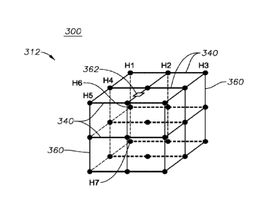
Figure 3 illustrates a diagram of a device 300 for acquiring seismic survey
data using
a multi-dimensional seismic sensor array 312 coupled to an unmanned marine
vessel (e.g., the unmanned marine vessel 10 of Figure 1A) in accordance with
implementations of various techniques described herein. The multi-dimensional
seismic sensor array 312 may be coupled with a hull of the unmanned marine
vessel
(e.g., a wave glider float) via an umbilical cord, and the seismic sensor
array 312
may be configured to acquire seismic survey data and calculate pressure
gradients
in multiple directions. Further, the multi-dimensional seismic sensor array
312 may
be configured to float beneath an unmanned marine vessel at a pre-determined
deployment depth in a water column.
In one implementation, the multi-dimensional seismic sensor array 312 may
include
multiple seismic streamers 340 (e.g., at least nine seismic streamers)
arranged in a
multi-dimensional geometric structure, e.g., a cuboid type lattice structure
having
three planar levels of three seismic streamers spaced apart at similar spatial
intervals. In this embodiment, 3 seismic streamers x 3 rows of seismic
streamers = 9
seismic streamers. In some implementations, the multi-dimensional seismic
sensor
array 312 may include a frame 360 with multiple seismic streamers 340 (e.g.,
at least
nine seismic streamers) arranged in a multi-dimensional geometric structure
(e.g., a
cuboid) at pre-determined spatial intervals. As shown, the seismic streamers
340
may be spaced apart at pre-determined spatial intervals, which may be similar,
different, or random spatial intervals. I should be understood that the
streamers can
deviate from a straight configuration, and can have certain curved
characteristics or
portions. According to embodiments, fewer than nine seismic streamers can be
connected to form a cube or rectangular shaped array. Four seismic streamers
can
be connected to form a cube or rectangular shaped array.
In some implementations, the multi-dimensional seismic sensor array 312 may be
arranged in a multi-dimensional geometric structure, which may define a cuboid
type
lattice structure having four open side faces and two open end faces. The
cuboid
type lattice structure may include at least one seismic streamer coupled at
each
lateral edge where the four open side faces intersect, thus forming the four
seismic
streamers. The cuboid type lattice structure may further include at least one
seismic
12
CA 02935752 2016-06-30
WO 2015/113031
PCT/US2015/013038
streamer positioned between each lateral edge of the four open side faces,
thus
forming an additional four seismic streamers. The cuboid type lattice
structure may
further include at least one seismic streamer positioned within the cuboid
type lattice
structure, such as in a central region of the cuboid structure, thus forming
one
additional seismic streamers. In that embodiment, 4 seismic streamers + 4
seismic
streamers + 1 seismic streamer = 9 seismic streamers.
In some implementations, the multi-dimensional seismic sensor array 312 may
include three seismic streamers arranged in parallel to one another defining a
first
plane and two seismic streamers arranged in parallel to at least one of the
first three
seismic streamers and defining a second plane that is substantially
perpendicular to
the first plane.
In some implementations, the multi-dimensional seismic sensor array 312 may
include a plurality of hydrophones H1, H2, , H7
arranged in x-coordinate, y-
coordinate, and z-coordinate directions, as shown in Figure 3. Each seismic
streamer may include at least three hydrophones. As such, the multi-
dimensional
seismic sensor array 312 may include a 3D hydrophone array that can be
attached
to an unmanned marine vessel (e.g., a wave glider).
In some implementations, the multi-dimensional seismic sensor array 312 may
include the 3D hydrophone array that may include 9 short streamers. The
dimension
of seismic sensor array 312 may be (or substantially be) 1.2 m x 1.2 m x 1.2
m.
These dimensions can be smaller however and still function properly. The multi-
dimensional seismic sensor array 312 may include a horizontal streamer
separation
of (or substantially) 0.6 m and a vertical separation of (or substantially)
0.6 m. The
multi-dimensional seismic sensor array 312 may include three hydrophones per
streamer and an interval between the hydrophones may be (or substantially be)
0.6
m. According to these various embodiments, the multi-dimensional seismic
sensor
array 312 may allow for calculating the first and second derivatives of
pressure in
any or all of x, y, and z directions and detecting the direction of the
seismic arrival.
Using various implementations described herein, the pressure gradient and the
second derivative of pressure in any or all of x, y, and z directions may be
calculated.
Various implementations described herein may further allow for performing 3D
deghosting and also interpolation of the pressure in x and y directions.
Further, the
13
CA 02935752 2016-06-30
WO 2015/113031
PCT/US2015/013038
multi-dimensional seismic sensor array 312 may allow for detecting direction
of the
seismic arrival.
As described herein, a streamer in the multi-dimensional seismic sensor array
312
may be equipped with hydrophones and MEMS accelerometers. From
accelerometer measurements, the pressure gradient may be estimated in any or
all
of x, y, and z directions, and based on these gradient measurements and
pressure
measurements (hydrophone data), 3D receiver deghosting and interpolation may
be
performed. Pressure gradient sensors can also be used.
In some implementations, the multi-dimensional seismic sensor array 312 may
include a transponder 362. Further, the multi-dimensional seismic sensor array
312
may be equipped with the transponder 362 to allow for accurate positioning. As
such, the transponder 362 may be used with a positioning system, such as an
Ultra
Short Base Line (USBL) positioning system. The USBL may be referred to as a
Super Short Baseline (SSBL), and generally, the USBL may be used as an
underwater positioning system along with a vessel mounted transceiver to
detect
range and bearing of a target using acoustic signals.
Figure 4 illustrates a diagram of a device 400 for acquiring seismic survey
data using
a multi-dimensional seismic sensor array 412 coupled to an unmanned marine
vessel (e.g., the unmanned marine vessel 10 of Figure 1A) in accordance with
implementations of various techniques described herein. As described herein,
the
multi-dimensional seismic sensor array 412 may be coupled to a hull of the
unmanned marine vessel (e.g., a wave glider float) via an umbilical cord, and
the
seismic sensor array 412 may be configured to acquire seismic survey data and
calculate pressure gradients in multiple directions. Further, the multi-
dimensional
seismic sensor array 412 may be configured for floating beneath an unmanned
marine vessel at a pre-determined deployment depth in a water column.
In reference to Figure 4, the multi-dimensional seismic sensor array 412 may
include
a plurality of shallow water nodes 470 and a frame 460 having members that are
arranged to define a multi-dimensional geometric structure, such as, a multi-
dimensional cuboid type lattice structure. The frame 460 may be configured to
couple the shallow water nodes 470 together in the multi-dimensional geometric
structure, shape, or form. The multi-dimensional seismic sensor array 412 may
14
CA 02935752 2016-06-30
WO 2015/113031
PCT/US2015/013038
include a steering device 448, or thrusters as described above with reference
to
Figures 2-3.
The multi-dimensional seismic sensor array 412 may include eight shallow water
nodes 470. As shown in Figure 4, a first grouping of four shallow water nodes
470
may be coupled together and positioned at a first end of the multi-dimensional
seismic sensor array 412, and a second grouping of four shallow water nodes
470
may be coupled together and positioned at a second end of the multi-
dimensional
seismic sensor array 412. The first end is opposite the second end.
[0001] The multi-
dimensional geometric structure 412 may be configured to
define an expanded cuboid type lattice structure with three planar levels of
members
spaced apart at similar pre-determined spatial intervals. As shown, the first
grouping
of four shallow water nodes 470 may be coupled together to define a
rectangular
shape, and similarly, the second grouping of four shallow water nodes 470 may
be
coupled together to define another rectangular shape.
Further, in some implementations, the multi-dimensional geometric structure
may be
described as a cuboid type lattice structure having four open side faces and
two
open end faces, including a first open end face and a second open end face.
The
cuboid type lattice structure may include four shallow water nodes coupled in
a
rectangular shape at each lateral edge of the first open end face. The cuboid
type
lattice structure may further include another four shallow water nodes coupled
in a
rectangular shape at each lateral edge of the second open end face.
As described in reference to Figure 4, the multi-dimensional seismic sensor
array
412 may be constructed and/or manufactured using shallow water nodes 470. In
some implementations, each shallow water node 470 may include a hydrophone,
three component geophones, and a recording system configured to record
continuously for a certain period of time (e.g., 1 month). In some
implementations,
each of the shallow water nodes 470 may include one or more geophones arranged
in a vertical orientation and configured to calculate a second derivative of
pressure.
Further, a compass device and an inclinometer or MEMS accelerometer may be
included with the node and used to determine orientation of the node in a
water
column. Further, the frame 460 may be constructed and/or manufactured to hold
together eight shallow water nodes, as shown in Figure 4. Further, in some
CA 02935752 2016-06-30
WO 2015/113031
PCT/US2015/013038
examples, the multi-dimensional sensor array 412 may be coupled or attached to
an
unmanned marine vessel using a vertical decoupling mechanism (e.g., the
vertical
force decoupling mechanism 17 of Figure 1B).
In some embodiments, the dimensions of each node may be (or substantially be):
length = 521 mm, width = 208 mm, and height = 108 mm. In some embodiments,
the dimensions of the multi-dimensional seismic sensor array 412 may be (or
substantially be): 521 mm x 521 mm x 521 mm.
In operation, the multi-dimensional seismic sensor array 412 may include eight
shallow water nodes that may allow for calculating pressure gradients in
vertical and
horizontal directions. Also, having vertical geophones inside each shallow
water
node may allow for calculating the second derivative of the pressure.
Figure 5 illustrates a computing system 800 that may be used in connection
with
various implementations described herein that may be implemented. The
computing
system 800 (system computer) may include one or more system computers 830,
which may be implemented as any conventional computer or server. However,
those skilled in the art will appreciate that implementations of various
techniques
described herein may be practiced in other computer system configurations,
including hypertext transfer protocol (HTTP) servers, hand-held devices,
multiprocessor systems, microprocessor-based or programmable consumer
electronics, network PCs, minicomputers, mainframe computers, and the like.
The system computer 830 may be in communication with disk storage devices 829,
831, and 833, which may be external hard disk storage devices. It is
contemplated
that disk storage devices 829, 831, and 833 are conventional hard disk drives,
and
as such, will be implemented by way of a local area network or by remote
access.
Of course, while disk storage devices 829, 831, and 833 are illustrated as
separate
devices, a single disk storage device may be used to store any and all of the
program instructions, measurement data, and results as desired.
In some implementations, seismic data from the sensors may be stored in disk
storage device 831. The system computer 830 may retrieve the appropriate data
from the disk storage device 831 to process seismic data according to program
instructions that correspond to implementations of various techniques
described
herein. The program instructions may be written in a computer programming
16
CA 02935752 2016-06-30
WO 2015/113031
PCT/US2015/013038
language, such as C++, Java and the like. The program instructions may be
stored
in a computer-readable medium, such as program disk storage device 833. Such
computer-readable media may include computer storage media and communication
media. Computer
storage media may include volatile and non-volatile, and
removable and non-removable media implemented in any method or technology for
storage of information, such as computer-readable instructions, data
structures,
program modules or other data. Computer storage media may further include RAM,
ROM, erasable programmable read-only memory (EPROM), electrically erasable
programmable read-only memory (EEPROM), flash memory or other solid state
memory technology, CD-ROM, digital versatile disks (DVD), or other optical
storage,
magnetic cassettes, magnetic tape, magnetic disk storage or other magnetic
storage
devices, or any other medium which can be used to store the desired
information
and which can be accessed by the system computer 830. Communication media
may embody computer readable instructions, data structures or other program
modules. By way of example, and not limitation, communication media may
include
wired media such as a wired network or direct-wired connection, and wireless
media
such as acoustic, radio frequency (RF), infrared (IR), and various other
wireless
media. Further, combinations of any of the above may also be included within
the
scope of computer readable media.
In some implementations, the system computer 830 may provide output primarily
onto graphics display 827, or alternatively via printer 828. The system
computer 830
may store the results of the methods described above on disk storage 829, for
later
use and further analysis. Further, the keyboard 826 and/or the pointing device
825
(e.g., a mouse, trackball, or the like) may be provided with the system
computer 830
to enable interactive operation.
The system computer 830 may be located at a data center remote from the survey
region. The system computer 830 may be in communication with the receivers
(either directly or via a recording unit, not shown), to receive signals
indicative of the
reflected seismic energy. These signals, after conventional formatting and
other
initial processing, may be stored by the system computer 830 as digital data
in the
disk storage 831 for subsequent retrieval and processing in the manner
described
above. In one implementation, these signals and data may be sent to the system
computer 830 directly from sensors, such as geophones, hydrophones, and the
like.
17
CA 02935752 2016-06-30
WO 2015/113031
PCT/US2015/013038
When receiving data directly from the sensors, the system computer 830 may be
described as part of an in-field data processing system. In another
implementation,
the system computer 830 may process seismic data already stored in the disk
storage 831. When processing data stored in the disk storage 831, the system
computer 830 may be described as part of a remote data processing center,
separate from data acquisition. The system computer 830 may be configured to
process data as part of the in-field data processing system, the remote data
processing system or a combination thereof.
While Figure 5 illustrates the disk storage 831 as directly connected to the
system
computer 830, it is also contemplated that the disk storage device 831 may be
accessible through a local area network or by remote access. Further, while
disk
storage devices 829, 831 are illustrated as separate devices for storing input
seismic
data and analysis results, the disk storage devices 829, 831 may be
implemented
within a single disk drive (either together with or separately from program
disk
storage device 833), or in any other conventional manner as will be fully
understood
by one of skill in the art having reference to this specification.
While the foregoing is directed to implementations of various techniques
described
herein, other and further implementations may be devised without departing
from the
basic scope thereof, which may be determined by the claims that follow.
Although
the subject matter has been described in language specific to structural
features
and/or methodological acts, it is to be understood that the subject matter
defined in
the appended claims is not necessarily limited to the specific features or
acts
described above. Rather, the specific features and acts described above are
disclosed as example forms of implementing the claims.
18