Note: Descriptions are shown in the official language in which they were submitted.
CA 02936439 2016-07-08
WO 2015/104052
PCT/EP2014/050247
1
INVERSION METHOD
Technical field
The present invention relates to subsurface geological exploration methods and
inversion of electromagnetic data.
Background
Subsurface geological structures can be explored with a plurality of detection
methods.
The detection methods can be used to infer the presence of hydrocarbons in a
formation. Two examples of detection methods are seismic methods and
electromagnetic methods. Seismic methods are based on the detection of elastic
waves which travel through a formation. Electromagnetic methods are based on
the
detection of electromagnetic waves which propagate through a formation. A
specific
example of an electromagnetic method is the detection of marine controlled
source
electromagnetic (mCSEM) data. In this method, a vessel tows a dipole source
through
the seawater which emits a time-varying electromagnetic field into the earth.
This field
propagates through the formation and is detected by a plurality of sensors
which are
placed on the seabed or also towed behind a vessel. After the mCSEM data have
been collected by the sensors, the data need to be interpreted or inverted to
extract
information about the formation from the data. One way of inverting the data
is using a
numerical model to generate a simulated data set. If the model perfectly
represents
the formation and the propagation of the electromagnetic field through the
formation,
the simulated data will be identical to the measured data. The estimation of
the optimal
model can be formulated as an optimisation problem in which the distance
between the
real data and the simulated data is minimised. However, the inversion problem
is a
highly non-unique problem with many possible solutions and is ill-posed in the
Hadamard sense. This may lead to un-physical results of the inversion and
corresponding difficulties in interpretation. In order
to address this problem, a
regularisation term can be included in the optimisation problem. A spatially
uniform
smoothing parameter may be included in the horizontal and vertical directions
of the
formation.
CA 02936439 2016-07-08
WO 2015/104052
PCT/EP2014/050247
2
Some methods use a Tikhonov type regularization (Tikhonov, A. N. et al., 1977,
Solutions of ill-posed problems; W.H. Winston and Sons.) where additional
penalties
are included linearly into the cost functional. The penalties are designed to
enforce
certain properties in the inverted resistivity profile, and narrows down the
kernel of the
problem. This approach was taken, for example, by Zhdanov, et al. (SEG
technical
Program Expanded Abstracts, 26, F65-F76). However, this term needs to be
weighted
properly so that the regularizing information and the data information balance
each
other. A different approach was taken by Abubakar et al. (Geophysics, 73, F165-
F177),
where the regularizing term was included multiplicatively in the cost
functional, thus
eliminating the estimation of the trade-off between the different terms in the
cost
functional. For both approaches, however, the regularization is uniform
smoothing,
whereby smoothing operators are applied along the horizontal and vertical
directions,
thus ensuring a slowly varying resistivity profile in the inverted result.
Statement of invention
According to a first aspect of the invention, there is provided a method of
estimating
electromagnetic parameters of a geological structure, comprising: providing
controlled
source electromagnetic, CSEM, data of the structure, calculating a numerical
model
representing electromagnetic parameters of the structure and generating
simulated
CSEM data, discretising the numerical model based on prior knowledge of the
structure, defining a functional for minimising the distance between said
simulated
CSEM data and said CSEM data, wherein the functional comprises a
regularisation
term which depends on prior knowledge of said structure.
The electromagnetic parameters may be the conductivity of the geological
structure at
a plurality of locations of the structure. The regularisation term may have a
strength
which depends on the location of the structure and may comprise a plurality of
weights
corresponding to a plurality of geological locations, wherein some of the
locations are
defined with more confidence than other locations, and wherein locations
defined with
more confidence may be assigned higher weights than locations with less
confidence.
The regularisation term may comprise a plurality of weights corresponding to a
plurality
of geological locations, wherein the weights which are assigned to locations
with
horizons passing through them are lower than weights assigned to locations
without
3
horizons passing through them. The prior knowledge may comprise seismic survey
data.
According to a second aspect of the invention, there is provided a method of
estimating electromagnetic parameters of a geological structure, comprising
providing controlled source electromagnetic, CSEM, data of the structure,
calculating a numerical model representing parameters of the structure and
generating simulated CSEM data, discretising the numerical model based on
prior
knowledge of the structure, defining a functional for minimising the distance
between said simulated CSEM data and said CSEM data, wherein the functional
comprises terms correlating neighbouring geological locations in dependence on
prior knowledge of said structure.
The step of correlating may depend on the presence of a structural gradient
estimated from prior knowledge of said structure. The method may further
comprise
defining a first spatial direction in the tangential plane of said structure
and a second
spatial direction perpendicular to the tangential plane of said structure. A
high
correlation may be assigned to neighbouring locations in the first spatial
direction
and a low correlation may be assigned to neighbouring locations in the second
spatial direction.
The prior knowledge may comprise seismic survey data. The electromagnetic
parameters may be the conductivity of the geological structure at a plurality
of
locations of the structure. The first and second spatial directions may be
chosen
according to said step of discretising the numerical model.
According to a third aspect of the invention, there is provided a method of
generating a computer model of a geological structure of the Earth's
subsurface
using an inversion method of controlled source electromagnetic, CSEM, data,
the
method comprising:
providing the CSEM data of the structure;
calculating a numerical model representing electromagnetic parameters of
the structure and generating simulated CSEM data;
spatially discretising the numerical model based on prior knowledge of
stratigraphic horizons of the structure by dividing the model into regular
intervals
horizontally and by dividing a vertical interval between each stratigraphic
horizon
into a pre-determined number of sub-layers;
Date Recue/Date Received 2020-06-08
4
defining a functional for determining the distance between said simulated
CSEM data and said CSEM data, wherein the functional comprises a
regularisation
term which depends on the spatially discretised model; and
using an iterative procedure to determine the electromagnetic parameters
of the structure that minimise said functional, wherein said spatially
discretised
model comprising said electromagnetic parameters that minimise said functional
is
said computer model of the structure.
According to a fourth aspect of the invention, there is provided a method of
generating a computer model of a geological structure of the Earth's
subsurface
using an inversion method of controlled source electromagnetic, CSEM, data,
the
method comprising:
providing the CSEM data of the structure,
calculating a numerical model representing parameters of the structure and
generating simulated CSEM data,
spatially discretising the numerical model based on prior knowledge of
stratigraphic horizons of the structure by dividing the model into regular
intervals
horizontally and by dividing a vertical interval between each stratigraphic
horizon
into a pre-determined number of sub-layers,
defining a functional for determining the distance between said simulated
CSEM data and said CSEM data, wherein the functional comprises terms
correlating neighbouring geological locations in dependence on the spatially
discretised model; and
using an iterative procedure to determine the electromagnetic parameters
of the structure that minimise said functional, wherein said spatially
discretised
model comprising said electromagnetic parameters that minimise said functional
is
said computer model of the structure.
According to a fifth aspect of the invention, there is provided a computer
device
comprising:
a receiver for receiving controlled source electromagnetic, CSEM, data of
a geological structure;
a processor arranged to carry out the method as described herein.
According to a sixth aspect of the invention, there is provided a computer
readable
medium having stored thereon instructions for execution by a computer to carry
out
the method as described herein.
Date Recue/Date Received 2020-06-08
4a
Brief description of the drawings
Some embodiments of the invention will now be described by way of example only
and with reference to the accompanying drawings, in which:
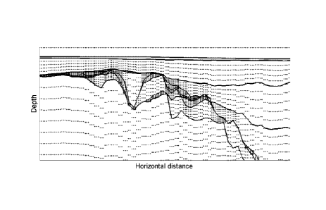
Figure 1 illustrates model discretisation;
Figure 2 illustrates output from a seismic chaos filter;
Figure 3 illustrates a p, function used to describe relative regularisation
strength;
Figure 4 illustrates an example of regularisation;
Figure 5 illustrates a true model in a synthetic example;
Figure 6 illustrates an initial model in a synthetic example;
Figure 7 illustrates a result of smoothing regularisation;
Figure 8 illustrates a relative difference between the result of smoothing
regularization and true model on synthetic example;
Figure 9 illustrates a result of structural regularization on a synthetic
example;
Figure 10 illustrates a relative difference between the result of structural
regularization and true model on synthetic example;
Figure 11 illustrates an initial half space model used in the inversion;
Figure 12 illustrates inversion results using smoothing regularization. Top
panel:
vertical resistivity, bottom panel: horizontal resistivity;
Figure 13 illustrates inversion results using structural smoothing
regularization.
Top panel: vertical resistivity, bottom panel: horizontal resistivity;
Figure 14 is a flow diagram of an estimation method;
Figure 15 is a flow diagram of an estimation method;
Figure 16 is a schematic illustration of a computer.
Date Recue/Date Received 2020-06-08
4b
Detailed description
The inventors have appreciated that a shortcoming of the smoothing
regularization
schemes is that they do not represent the geological geometry. The smoothing
Date Recue/Date Received 2020-06-08
CA 02936439 2016-07-08
WO 2015/104052
PCT/EP2014/050247
regularization and, for example, the minimum vertical support regularization
(Zhdanov
et al.) do not take into account a priori geological information that may be
available, for
example from seismic data. The present application discloses a Tikhonov-type
structural smoothing regularization approach that determines both the
directionality and
5 relative strength of the regularization from seismic data. The
regularization is still of a
smoothing nature, but acts mainly along the rock layers and layering, i.e. the
stratigraphy. The inventors have appreciated that changes in electric
parameters are
structurally conform changes in the elastic parameters. This use of prior
knowledge can
improve the interpretation of mCSEM data because the result is more directly
comparable to seismic data.
Herein disclosed is a method which includes at least two of the following
three steps:
first, the inversion parameters are designed to be conform with data
representing
stratigraphic surfaces in the earth. This step enables the model
discretization to
represent the geometry observed from the seismic data. The discretization is
obtained
by dividing the model into regular intervals horizontally, but not vertically.
The vertical
interval between each stratigraphic surface is divided into a pre-determined
number of
sub-layers. Thus, where the thickness of a layer is large, the inversion cells
are set to
be larger, and when the stratigraphic surfaces approach each other, the
inversion cells
are set to be smaller. By way of example of data representing stratigraphic
surfaces,
horizons may be used, which are interfaces indicative of a particular position
in a
stratigraphic sequence. Horizons may refer to boundaries between stratigraphic
units,
or to markers within those units.
Second, a spatially varying relative strength of the regularization is
determined from a
seismic chaos attribute. At locations where there is little noise or little
uncertainty in the
seismic data, for example along reflectors and homogeneous packages, a large
weight
is assigned to the regularisation term to ensure a smooth profile. At
locations where
there is more noise and a relatively large uncertainty in the seismic data, a
correspondingly small weight is assigned to allow for more variations. Any
attribute with
similar properties may be used.
Thirdly, the smoothing direction is determined using the model discretization
described
in the first step. Structure from prior geophysical data is used to describe
at each
spatial point two new directions: along and orthogonal to the dip direction. A
high
CA 02936439 2016-07-08
WO 2015/104052
PCT/EP2014/050247
6
dependency between neighbouring points along the dip direction and a low
dependency between neighbouring point orthogonal to the dip direction can be
enforced. The smoothing now acts mainly along each sub-layer, which by design
follows the stratigraphy.
By way of example, an inversion algorithm is described as follows. The example
illustrates a 2 dimensional model, but the example may also be generalised to
a 3
dimensional model. The electromagnetic inversion problem is an optimisation
problem:
find the conductivity a which minimises the functional (equation 1):
E r) (I ¨ (g(a))
In this functional, g(a) is an injective function for a > 0. These functions
are usually
chosen to make updates in specific ranges easier for the optimization
algorithm or to
resolve parameter scale issues, for example, g=o-, g=logo-, g=o-1/2. Further,
A2>0 is a
regularization parameter which controls the trade-off between the data fit and
the
regularizer, and Ereg is a regularizing term to enforce specific properties in
the solution.
The data are gathered in the vector d, and F denotes the forward modelling
operator.
The data weights W are chosen according to Morton et al. (CSEM data
uncertainty
analysis for 3D inversion: SEG, 724-728).
If smoothing regularization is used, the regularization term in equation 1 may
be
chosen as (equation 2):
,
a
(a) g 7
p
In equation 2, ax, a, 13 c R and II '11 p c N denote the common p-norm. For
example,
ax a, which enforces flatness.
The cost-functional as defined in equation 1 may be minimized iteratively
using a
Gauss-Newton algorithm. After a search direction is found by solving the
equations, a
line search with back-tracking may be performed to improve convergence.
CA 02936439 2016-07-08
WO 2015/104052
PCT/EP2014/050247
7
Herein is illustrated how the structural regularization is set up using a
field data
example, for which the inversion results will also be illustrated. We assume
that seismic
data imaged in depth is available, together with interpreted horizons.
The model is first discretised. To obtain structurally regularized inversion
results, a
suitable model representation is chosen. The model is therefore discretised
into
inversion cells, each cell with constant conductivity, conform the interpreted
horizons.
The model is discretized into Ab, regular intervals with a fixed length in the
horizontal
direction, but are allowed to vary in the vertical direction. At each vertical
profile, the
vertical interval between each horizon is divided into a predetermined number
of
inversion cells. Thus, when the distance between the horizons is large, the
cells
become wide, and when the horizons approach each other, the cells become
smaller.
This constructs sub-layers in between the horizons that follow the structure,
and has
the property that each horizontal location has the same number of grid cells,
Alz,
vertically. When horizons come too close together such that the inversion
cells become
smaller than the modelling grid size, they are removed from the inversion
grid. This
removal is justified because they have become too small to resolve with mCSEM
data
on the chosen modelling grid. An example of a model discretization is shown in
Figure
1. The vertical axis indicates the depth and the horizontal axis indicates the
horizontal
distance.
The spatially varying relative strength of the regularization, 13, is
determined from the
seismic chaos attribute. Now 13 : Rn-9R, rather than /3 E R, where n is the
dimension of
the resistivity model. For each sample in a seismic cube it associates a
number
0 c 1, which
describes the local chaotic behaviour. Here, c=0 is no chaos or
uncertainty, while c=1 is complete chaos. The output of this filter is shown
in Figure 2,
The output from the chaos filter is then mapped onto a spatially varying
function 13
according to
=
where K controls the absolute level. The factor -5 in the exponent was chosen
by
inspection, and is found to give a good separation between high values and low
values.
Further, we must have 13 0 to maintain non-singular equations. Thus, 13 also
has a
threshold from below. It was also appreciated that associating low 13-values
at grid cells
CA 02936439 2016-07-08
WO 2015/104052
PCT/EP2014/050247
8
intersected by horizons has a positive effect on the estimation, and
encourages
contrasts at these locations. Finally, a Gaussian running averaging filter was
applied for
smoothing.
A small value of 13 means that we expect the chaotic behaviour in the seismic
to imply
also a less smooth variation of the conductivity. On the other hand, where
there is little
chaos in the seismic data we expect a smoother resistivity profile. The final
I3-function
used is shown in Figure 3. This example for the construction of 31s specific,
but the
inventors have appreciated that there are many different ways to construct 13
such that
high values of p are assigned to locations with low chaos and low values of 13
are
assigned to locations with high chaos.
Alternatively, the spatially varying weights 13 which are assigned to
locations may be
chosen such that weights with horizons passing through them are lower than
weights
assigned to locations without horizons passing through them.
The regularisation term in equation 1 may also be modified. This modification
may be
assigned in addition to the spatially varying relative strength of the
regularization, or
instead of the spatially varying relative strength.
A new regularisation term is defined as (equation 3):
a
P)
= (
Cid
In equation 3, x' and 2 are new horizontal and vertical directions to be
specified
according to the new model discretisation. The difference with equation 2 is
that in
equation 3 the smoothing in the horiontal and vertical direction is coupled to
define a
direction, and that the weights vary spatially in a way consistent with
seismic
information. The smoothing direction is determined, for example, from seismic
horizons. Grid points at the horizons are given the direction of the tangent
of the
horizon. The direction associated with a grid point in-between horions is
interpolated
between the tangents of the horizons immediately aove and below. For some
applications, it may be favorable to use only the tangent from the horizon
above, while
CA 02936439 2016-07-08
WO 2015/104052 PCT/EP2014/050247
9
as other times only the one below. However, to ensure a smoothly varying
direction, a
linear interpolation with respect to the vertical distance is the default. The
definition of
the new horizontal and vertical directions in equation 3 correlates
neighbouring
geological locations in dependence on the presence of a structural gradient
estimated
from prior knowledge of said structure.
The derivative for a conductivity model a is further defined, discretised onto
the
inversion grid evaluated in the grid point ix, iz as
8
= g2 (a (ix, iz) , - 92 (a )
¨92 la iX i'Z))
824
a ,
- kc- =
3))
az' L.,
where 1p3, ipx. iqx, iq, are indexing arrays of dimension 1\13xN, describing
which inversion
grid cell we shall regularize against, and Ax' and Az' are mesh sizes in the
new model
discretization. The indexing arrays ipx, ip, now determines the new horizontal
direction
within the sub-layer specified by the model discretization, and iqx, iq, does
the same for
the new vertical direction. These arrays have to take into account that some
of these
cells may disappear when horizons come too close, and re-appear when they
diverge
again. In such situations the indexing is not to a cell's immediate neighbor
in the
sublayer. An example of the regularization for a given cell is shown in Figure
4.
We observe that if we choose a regular inversion grid, and define element (ix,
iz) in the
indexing arrays as
= ix +1,
"Ix ' =
' = iZ 1
we obtain the smoothing regularization in equation 2 approximated using
forward
differences. The smoothing regularization is a special case of the more
general
indexing strategy.
CA 02936439 2016-07-08
WO 2015/104052
PCT/EP2014/050247
The result of a calculation based on the specific embodiments discussed above
is now
presented. The synthetic model we use is shown in Figure 5. It consists of a
gently
dipping seabed, an oscillating subsurface interface and a straight, dipping
subsurface
5 interface. The uppermost subsurface layer is isotropic with resistivity
Rh = Rv = lOhm-
m. The next two layers are anisotropic with horizontal and vertical
resistivities Rh=2
Ohm-m and Rv=6 Ohm-m, and Rh=100hm-m and Rv=200hm-m, respectively. The
water is chosen isotropic with Rh = Rv=0.31250hm-m. At approximately 1000m
depth
below sea surface an isotropic 500hm-m reservoir is positioned. This model
allows
10 testing of the regularization scheme on both plane and curved
interfaces, how it deals
with thin resistors, and comparing it against the conventional regularization.
The input data are inline electric fields recorded at the 10 receivers, spaced
lkm apart.
Offsets ranging from 2-10 km was used on each receiver, with a noise floor at
10-15V/Am2 and 5% Gaussian noise added. The source elevation was 30m above the
seabed, and frequencies of 0.25, 0.5, 1 Hz were used. For this example, ax=1,
az=0.03,
p=1, and g(a)=Nla. The regularization strength, A2 was reduced by 5% in each
iteration
until the RMS misfit normalized against the added noise passed below 1. The
initial
model was chosen as an isotropic 20hm-m half space model, shown in Figure 6.
This
example is a synthetic example.
Figure 7 shows the result from inversion with the smoothing regularization,
while Figure
8 shows the relative difference between the inversion result in Figure 7 and
the true
model in Figure 5. The coresponding figures for the structural regularization
is shown in
Figures 9 and 10. Comparing the inversion results in Figures 7 and 9, we
observe that
although the smoothing regularization is able to mimic the main trends, the
structural
regularization result has sharper interfaces. Further, especially at the
deepest interface,
the horizontal smoothing in the regularization degrades the result. The RMS
misfit for
the smoothing regularization was 4.9%, while for the structural regularization
it is 5.0%.
Also, the regularization places the resistor slightly wrong in depth. All
results match the
data to the uncertainty level.
Comparing the relative difference images in Figures 8 and 9, the effect of the
regularizer is even more prominent. Focusing on the oscillating interface in
Figure 8,
we observe that the errors following the smoothing horizontally, while in
Figure 10 is
CA 02936439 2016-07-08
WO 2015/104052
PCT/EP2014/050247
11
follows the interface. Moreover, the errors are generally lower in the
strcutral
regularization. This is due to the a priori information about the interfaces
being correct,
thereby enabling a more accurate image of the true model.
A further example is illustrated for real CSEM survey results. For this
example we
have chosen ax=1 , u=0.1, p=1, and g(a)----\Ics. The line consists of 9
receivers, the
horizontal dipole source was towed approximately 30m above the seabed, and the
inversion was run using frequencies 0.2Hz and 0.4Hz. The initial model was the
anisotropic half space model shown in Figure 11. The inversions ran until the
backtracking algorithm could not find a better data fit. The regularization
strength, A2
was reduced by 5% in each iteration until the RMS misfit normalized against
the
assumed measurement uncertainty passed below 1.
Figures 12 shows the results with regularization using inline data. We observe
a clear
anomaly at approximately 1800m depth. The center of the anomaly is slightly
shifted
from the apex of the structure and it is very smeared out laterally. It is
difficult to say
whether it is associated with higher resistivity in an entire package, a more
localized
resistivity anomaly, or both. Further, in the lower parts of the section the
resistivity
variations cuts across the interpreted horizons. The RMS misfit for the
inversion is
2.8%, below the assumed uncertainty level of the data of 4-5%.
In Figure 13, we show the result of our structural regularization with inline
electric field
data. We now see that that the main anomaly is split into three anomalies,
each with
higher resistivity than before. This indicates that it is not an increased
resistivity in the
entire layer, but rather localized anomalies. This is in compliance with the
interpretation
from seimic data. The effect of the regularization is clearly visible in that
now the
inverted resistivity profile follows the geometry dictated by the seismic
horizons. The
RMS misfit for the inversion is 3.2%.
Figure 14 illustrates schematically the method of estimating electromagnetic
parameters of a geological structure discussed above, comprising the steps of
providing controlled source electromagnetic, CSEM, data of the structure (Si),
calculating a numerical model representing electromagnetic parameters of the
structure
and generating simulated CSEM data (S2), discretising the numerical model
based on
CA 02936439 2016-07-08
WO 2015/104052
PCT/EP2014/050247
12
prior knowledge of the structure (S3) and minimising the cost function (S4)
with a
regularisiation term which depends on prior knowledge of the structure.
Figure 15 illustrates schematically the method of estimating electromagnetic
parameters of a geological structure discussed above, comprising the steps of
providing controlled source electromagnetic, CSEM, data of the structure
(S21),
calculating a numerical model representing electromagnetic parameters of the
structure
and generating simulated CSEM data (S22), discretising the numerical model
based on
prior knowledge of the structure (S23) and minimising the cost function (S24)
comprising terms correlating neighbouring geological locations in dependence
on prior
knowledge of said structure.
Figure 16 illustrates schematically in a block diagram a computer device (15)
that is
arranged to carry out the method disclosed above. The computer device is
provided
with a processor (16) and a receiver (17) for receiving controlled source
electromagnetic, CSEM, data of the structure. On the basis of the received
data and a
model, the processor makes an estimate of parameters of the geological
structure. A
transmitter (18) is provided for providing an output of the estimated
parameters.
A non-transitory computer readable medium in the form of a memory (19) may
also be
provided that can be used to store data. It may also be used to store a
computer
program (20) which, when executed by the processor, causes the computer device
to
behave as described above.
Although the invention has been described in terms of preferred embodiments as
set
forth above, it should be understood that these embodiments are illustrative
only and
that the claims are not limited to those embodiments. Those skilled in the art
will be
able to make modifications and alternatives in view of the disclosure which
are
contemplated as falling within the scope of the appended claims. Each feature
disclosed or illustrated in the present specification may be incorporated in
the
invention, whether alone or in any appropriate combination with any other
feature
disclosed or illustrated herein.