Note: Descriptions are shown in the official language in which they were submitted.
CA 02938611 2016-08-02
WO 2015/130794 PCT/US2015/017537
SINGLE PLATFORM DOPPLER GEOLOCATION
BACKGROUND
FIELD
This invention relates generally to vehicle-mounted geolocation system. More
particularly, this invention relates to a light size and weight system that
consumes little
power when it locates the position of emitters of electromagnetic radiation.
DESCRIPTION OF RELATED ART INCLUDING INFORMATION DISCLOSED
UNDER 37 CFR 1.97 AND 1.98
In the field, troops do not have an effective tactical asset under troop
control
that is capable of locating hostile emitters that emit signals to communicate
and/or
control equipment under the control of a hostile entity. Geolocation using
time
difference of arrival (TDOA) or frequency difference of arrival (FDOA)
techniques
typically require multiple platforms that are synchronized in time or
frequency so that
differences between platforms can be calculated. Usually, this synchronization
is
done with atomic clocks or synchronized stable local oscillators.
Synchronization
also requires electronics that consume more power or weigh more than can be
carried
by a small unmanned air vehicle (UAV) while maintaining persistence
requirements
and maintaining flight control stability. Another alternative for geolocation
from a
single platform require multiple element antennas to determine angles of
arrival of the
signals in order to determine a target angular location. These solutions may
provide
simple azimuth information, but fails to provide any information regarding
range.
More complex arrays could provide azimuth and elevation that could be used to
determine range and azimuth. However, complex arrays require calibration and
consume power. Additionally, complex arrays weigh more and potentially affect
aerodynamics, diminishing the flight control system performance of a small
tactical
UAV. As such, these solutions can only be incorporated into larger platforms
not
under the control of the end user (troops in the field) and can only be taken
advantage
of using multiple airborne platforms, if available, even though they may not
be tightly
synchronized in time down the carrier phase level.
1
CA 02938611 2016-08-02
WO 2015/130794 PCT/US2015/017537
SUMMARY
A geolocation system for identifying a location of an emitting source is
disclosed wherein the geolocation system is hosted by a moving craft. The
geolocation system includes an omnidirectional antenna used to collect source
signals
emitted by the emitting source. A signal processor is an electrical
communication
with the antenna and receives the source signals collected by the antenna. The
signal
processor extracts frequency data from the source signals. A frequency
estimator is
electrically connected to the signal processor. The frequency estimator
estimates a
frequency of the source signals independent of a center frequency or a
frequency drift
rate of the source signals. A controller calculates the location of the
emitter source
based upon the frequency estimator output.
DRAWING DESCRIPTIONS
Figure 1 is a perspective environmental view of a geolocation system of the
prior
art;
Figure 2 is a perspective environmental view of a geolocation system according
to one embodiment of the invention hosted by an aircraft;
Figure 3 is a block diagram of one embodiment of the inventive system;
Figure 4 is a block diagram of a frequency estimator according to one
embodiment of the invention;
Figure 5 is a block diagram of the inventive method; and
Figure 6 is a logic chart of one embodiment of the inventive method.
DETAILED DESCRIPTION
Aircraft have been used for tactical reconnaissance for almost as long as
aircraft have been in existence. As technology changed, so too did the type of
information gathered as well as how it was gathered. With the advent of UAVs,
targets that are less permanent in nature have been easier to locate. This is
because
the UAV may be able to get closer to the target without being discovered.
2
CA 02938611 2016-08-02
WO 2015/130794 PCT/US2015/017537
Referring to Figure 1, a graphic representation of how UAVs were used prior
to the invention is shown. In this situation, a target 10 is graphically
represented as a
satellite antenna and is a surrogate for any type of emitter even as simple as
a
handheld radio transceiver. It should be appreciated by those skilled in the
art that the
unknown emitter may be attached to a permanent structure or it may be an
emitting
device that is mobile. Signals transmitted by the target antenna are
graphically
represented by arrows 12, 14. The signals 12, 14 are received by antenna (not
shown)
hosted by a plurality of UAVs 16. In addition, a land-based receiving station
18 may
also receive a signal 20 emitted by the target at 10. Information from the
plurality of
UAVs 16 is transmitted (graphically represented by lightning symbols 22, 24)
to the
land-based receiving station 18. With the information transmitted by the
plurality of
UAVs 16 and in addition to the signal 20 received by the land-based receiving
station
18, the land-based receiving station 18 may calculate the location of the
target antenna
10. This system is cumbersome in that it requires the synchronization of all
the
plurality of UAVs 16 as well as having the personnel required to control and
operate
the UAVs 16.
Referring to Figure 2, one embodiment of the inventive assembly is generally
indicated at 26. Like the plurality of UAVs 16 in the prior art shown in
Figure 1, a
UAV 28 receives a signal 30 of electromagnetic radiation from the target
antenna 10.
After the UAV 28 receives the signal 30, it transmits the signal (graphically
represented by lightning symbol 32) to a land-based receiving station 34,
which then
calculates the location of the target antenna 10. The UAV 28 includes a single
monopole antenna 36 consisting of a simple omnidirectional element array
designed
to receive the signal 30 from the target antenna 10. An omnidirectional
element array
is an antenna that receives signals uniformly in all directions in one plane.
These
omnidirectional element arrays may be monopole or dipole antennas. Use of the
simple omnidirectional element array reduces the size, weight and power (SWAP)
of
the geolocation system 26. The design of the single, monopole antenna 36 will
hereinafter be referred to as an omnidirectional antenna 36. The operation of
the
UAV 28 will be discussed in greater detail subsequently. It should be
appreciated by
those skilled in the art that the craft disclosed as UAV 28 may be any type of
craft or
vehicle as the invention can be utilized with any moving platform.
3
CA 02938611 2016-08-02
WO 2015/130794 PCT/US2015/017537
Referring to Figure 3, a block diagram of the inventive assembly 26 is
generally shown. The geolocation system includes an airborne sensor 38, which
is
hosted by the UAV 28 in Figure 2, and a computerized ground processing station
40,
which is graphically represented by the land-based receiving station 34 in
Figure 2.
The airborne sensor 38 receives the signal 30 using a digital receiver 42. The
signal
may be analog or digital, consistent or intermittent. The communication rate
may be
low and the geolocation system 26 will account for low communication rate. The
signal received by the digital receiver 28 from the omnidirectional antenna 36
is sent
to both a noise density estimator 44 and a frequency estimator 46. The noise
density
estimator 44 measures the signal-to-noise ratio (SNR) and sends the measured
SNR to
both the frequency estimator 46 and the ground processing station 40. The
airborne
sensor 38 also includes a navigation system 48. The output of the navigation
system
48 is also sent to the ground processing station 40, which hosts at least one
computer
that will process the outputs received.
Referring to Figure 4, a more detailed representation of the computerized
frequency estimator 46 is shown. As stated above, the frequency estimator 46
receives inputs from the digital receiver 42 and the noise density estimator
44. A
quality estimator 50 receives the output of the noise density estimator 44.
The output
of the quality estimator 50 is received by a signal data buffer 52. The signal
data
buffer 52 also receives the output of the digital receiver 42. A modulation
detector 54
detects how the signal received by the digital receiver 42 is modulated. This
is
required because the geolocation system 26 is going to be required to detect
signals of
unknown frequency. Based on the output of the modulation detector 54, an
estimator
selector 56 selects, as is graphically represented by a switch 58 between a
plurality of
estimators 60 to select the proper estimator for the signal 30 received by the
digital
receiver 42. While three estimators 60 are shown in Figure 4, it should be
appreciated
by those skilled in the art that any number of estimators may be used to
estimate the
frequency of the signal 30 received by the digital receiver 42. The output of
the
frequency estimator 46 is sent to the computerized ground processing station
40,
identified in Figure 4 as the geolocation processing.
4
CA 02938611 2016-08-02
WO 2015/130794 PCT/US2015/017537
Returning attention to Figure 3, the ground processing station 40 includes an
emitter location processor 62 (this processor may be part of the airborne
platform or
the ground station processing as depicted) that receives all of the outputs of
the
airborne sensor 38. The emitter location processor 62 may receive outputs from
a
plurality of airborne sensors 38 (one shown) and does not require multiple
platform
synchronization (timing on the order of 0.1 second is all that is required).
The location processor 62 receives outputs from the noise density estimator
44, the navigation system 48, and the frequency estimator 46. Together with a
database incorporating the digital terrain elevation data 64, the ground
processing
station 40 can identify the location of the target 10. The digital terrain
elevation data
64, is not absolutely necessary, but may improve the geolocation height
estimate.
Referring to Figure 5, a graphic representation of a data flow for a method
utilized by the geolocation system 26 is generally shown at 66. Signal
processing
occurs at 68 to extract the frequency of arrival for a particular signal 30.
The signal
processing includes information received from the navigation system 48. The
frequency of arrival information and the platform position and velocity
information
from the navigation system 48 are incorporated as inputs into a geolocation
algorithm
70, which then identifies the location of the target emitter 10.
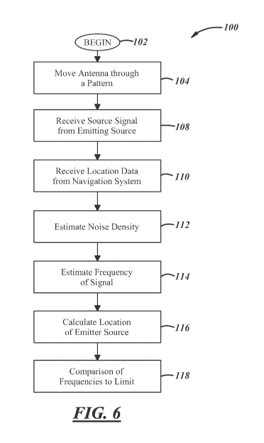
Referring to Figure 6, one embodiment of the inventive method is graphically
shown in a flow chart, generally indicated at 100. The method begins at 102.
The
first step in the method 100 is to move the omnidirectional antenna 36 through
a
pattern at 104. The pattern is graphically shown in Figure 2 as a circle 106.
Depending on the conditions or the type of signal to be collected, the pattern
106 may
be something other than a circle pattern. Regardless of the shape of the
pattern, the
pattern 106 may be repeated or only a portion of the pattern may be utilized.
Performance is dependent on the specific platform-emitter geometry over the
time
interval of data collection.
As the omnidirectional antenna 36 is moved through a pattern, a source signal
is received from the emitting source or target 10 at 108. The system also
receives
5
CA 02938611 2016-08-02
WO 2015/130794 PCT/US2015/017537
location data from a navigation system at 110. Noise density is calculated
from the
source signal as it is received from the emitting source 10 at 112.
The frequency of the source signal is estimated at 114. Because the
omnidirectional antenna 36 is used to identify the geolocation of the emitting
source
or target antenna 10, estimating the frequency of the signal at 114 requires
identifying
the frequency of the signal source that is affected by the Doppler frequency
shift
based on the location and movement of the omnidirectional antenna 36. To do
this,
a calculation of time dilation must be made since the Doppler shift is itself
time
varying. Ignoring amplitude changes, the relationship between transmitted and
received signals is:
CT (0 = If s - R(
µt + T (0) ¨ i ' T WI (1)
where letter c is the speed of wave propagation, T (t) denotes the value of
travel time and is=T(t) and is=R(t) are position vectors of the transmitter
and receiver,
respectively. In addition to time dilation, the average Doppler frequency
shift over
the same period of time must be calculated. This is done using the following
equation:
[rRT(t+772)¨rRT(t-772)1
A fav g (t) = ¨ i T , Af (s)ds = (2)
1 pt+172
where rRT (t) is the distance between the platform receiver and the unknown
transmitter (emitter), A is the wavelength and A f (t) is the instantaneous
Doppler
frequency shift at time t.
When considering the case of a stationary emitter 10, the average Doppler
shifts correspond to scaled range difference measurements (or TDOA) for
positions of
the receiver at the beginning and end of the time interval for the average.
The
equivalent time differences are:
T A, ,N õ,
T(t + 172) ¨ T(t ¨ 172) = ¨ To LII av g W ) =
This observation is important since Doppler emitter localization performed
here is based on range difference processing over a synthetic aperture. The
approach
6
CA 02938611 2016-08-02
WO 2015/130794 PCT/US2015/017537
used here in one implementation is a completely linear TDOA or range
difference
solution, even for a single platform. This linear formulation can be used as a
starting
point for iterative refinement by including additional non-linear equations.
Nevertheless, using the average Doppler shifts, emitter locations can be
computed
using a standard TDOA overdetermined set of linear equations. In this simple
formulation, the use of range differences assumes fo or are known. This is not
essential and the method is modified to estimate both an unknown center
frequency
and unknown frequency drift rate or alternatively to reformulate the equation
set to
eliminate them as nuisance parameters.
When neither the center frequency nor the frequency drift rate are known, a
few iterations near the correct solution reduce the error. To refine the
solution, the
Jacobian of the nonlinear equations must be calculated. The frequency model
with an
unknown frequency and drift rate is:
fm (t) = h(t, 0) + n(t) (4)
= fo (1 _ (t)_tRT) + fat (5)
f (t) = h(t, 0)
c 1
= fo (1 viR.T(ouRT(0)
+ fat (6)
The Jacobian of h(t,0) with respect to 0 is given by:
viTT(oRT
u(t)) t fo
)
V' h(t, 0) = [(1 VT (0 (I
RT URT (t)U7R T (0)1 (7)
crRT(t)
= kf
a
01 (8)
and details of the Jacobian calculation can be found Sampling at time instants
ti the vector equation for the frequency measurement is
fm(ti) h(ti, 0) n(ti)
m
[fm(t2)I = [h(t2, 0)1 + [n(t2)I=
f = h(0) + n (9)
fm(tN) h(tN, 0) n(tN)
7
CA 02938611 2016-08-02
WO 2015/130794 PCT/US2015/017537
The Taylor series in 0 is about 00 for h(0) is
h(0) = h(00) + Vh(00)(0 ¨ 00) + - = (10)
so that the approximate linear equation can be written as
h(00) + Vh(00)(0 ¨ 00) + n (11)
The covariance of n is denoted R and n has independent identically distributed
components so that
R = cr1 (12)
The standard least squares solution to Equation 11, above, leads to a
nonlinear
Newton type of iteration for 0 given by
k+1 = k + [V11(0 Or (fm - 11(0 k)) (13)
where A# denotes the pseudoinverse of A. The initial 00 is provided by the
linear geolocation algorithms as a starting point to refine or improve.
Equation 13 is a
Gauss-Newton solution for 0. By modifying Equation 13, a robust convergence is
achieved. More specifically, the step size (from Ok to Ok+i) in Equation 13 is
modified
to explicitly put a limit or maximum step size for testing based on a
particular
application and field of view. This modification is built into the geolocation
system
26 allowing for automatic convergence metrics. As such, convergence is
achieved
without the need for multiple coordinated sources, an antenna array, tight
receiver
synchronization, or pulsed signals.
With the frequency of the signal estimated, the location of the unknown source
is calculated at 116 based on the estimated frequency and as it is measured
over time.
This description, rather than describing limitations of an invention, only
illustrates an embodiment of the invention recited in the claims. The language
of this
description is therefore exclusively descriptive and is non-limiting.
Obviously, it's
possible to modify this invention from what the description teaches. Within
the scope
of the claims, one may practice the invention other than as described above.
8