Note: Descriptions are shown in the official language in which they were submitted.
SPATIAL SAMPLING IMPROVEMENTS AND THE
FORMATION OF ARRAYS USING POPCORN AND
SIMULTANEOUS SOURCE ACQUISITION
100011
TECHNICAL FIELD
[0002] This disclosure relates to the general subject of seismic surveillance
and, in particular,
to methods for acquiring seismic and other signals that are representative of
the subsurface
for puiposes of seismic exploration and/or surveillance.
BACKGROUND
[00031 A seismic survey represents an attempt to image or map the subsurface
of the earth by
sending sound energy down into the ground and recording the "echoes" that
return from the
rock layers below. The source of the down-going sound energy might come, for
example,
from explosions or seismic vibrators on land, or air guns in marine
environments. During a
seismic survey, the energy source is placed at various locations near the
surface of the earth
above a geologic structure of interest. Each time the source is activated, it
generates a
seismic signal that travels downward through the earth. "Echoes" of that
signal are then
recorded at a great many locations on the surface. Multiple source / recording
combinations
are then combined to create a near continuous profile of the subsurface that
can extend for
many miles. In a two-dimensional (2-D) seismic survey, the recording locations
are
generally laid out along a single line, whereas in a three dimensional (3-D)
survey the
recording locations are distributed across the surface in a grid pattern. In
simplest terms, a 2-
D seismic line can be thought of as giving a cross sectional picture (vertical
slice) of the earth
layers as they exist directly beneath the recording locations. A 3-D survey
produces a data
"cube" or volume that is, at least conceptually, a 3-D picture of the
subsurface that lies
beneath the survey area. In reality, though, both 2-D and 3-D surveys
interrogate some
volume of earth lying beneath the area covered by the survey. Finally, a 4-D
(or time-lapse)
survey is one that is recorded over the same area at two or more different
times. Obviously,
Date Recue/Date Received 2020-06-24
CA 02939362 2016-08-11
WO 2015/138923
PCT/US2015/020477
if successive images of the subsurface are compared any changes that are
observed (assuming
differences in the source signature, receivers, recorders, ambient noise
conditions, etc., are
accounted for) will be attributable to changes in the subsurface.
100041 A seismic survey is composed of a very large number of individual
seismic recordings
or traces. The digital samples in seismic data traces are usually acquired at
0.002 second (2
millisecond or "ms") intervals, although 4 millisecond and 1 millisecond
sampling intervals
are also common. Typical trace lengths are 5 ¨ 16 seconds, which corresponds
to 2500 ¨
8000 samples at a 2-millisecond interval. Conventionally each trace records a
source
activation so there is one trace for each live source location-receiver
activation. Note that, for
purposes of the instant disclosure, the term "source" should be understood to
mean either a
single seismic signal device or a collection of seismic signal devices (which
might be
clustered or spaced apart) that are to be activated simultaneously or both. It
should be clear
from the context in which is intended. In a typical 2-D survey, there will
usually be many
source activation at different locations which can result in several tens of
thousands of traces,
whereas in a 3-D survey the number of individual traces may run into the
multiple millions of
traces.
100051 In seismic acquisition a marine source array, usually an array of air
guns, is composed
of many single units that are towed behind a vessel that travels over the
survey area. These
units (e.g., air guns, water guns, sparkers, boomers, chip systems, water
sirens, etc.) are
typically hung in a line under a sausage buoy to allow them to be towed in a
streamlined
fashion. It is typical in deep water seismic surveying to use 6 to 8 guns
under a single buoy.
This configuration of seismic sources is conventionally referred to as a sub-
array. For
purposes of the instant disclosure, the term "array" will be understood to
refer to the totality
of sources that are to be utilized in a seismic survey, in the marine case
whether towed by one
boat or two or more. A subarray (which might consist of one or more sources)
will be
understood to be a subset of the sources that are to be activated
simultaneously.
100061 If more guns are needed to achieve the desired signal properties,
additional subarrays
are typically used to prevent the sausage buoy and seismic gun array from
becoming too long
to fit in the available space on deck and to prevent it from becoming
excessively directional
and excessively long. Excessively long and directional arrays have undesirable
properties.
For example, if the number of guns necessitates an array that is several tens
of meters long,
not only would the buoy and array be too long to fit onto a typical seismic
vessel, but the
signal emitted by the array would be received by the seismic receivers with a
great deal of
2
CA 02939362 2016-08-11
WO 2015/138923
PCT/US2015/020477
differential normal moveout. That is, because of the different locations
within the subarray
the signal path and travel time for each source varies enough such that the
difference amounts
to a fair fraction of a temporal period. Thus, the higher frequency components
will tend to be
out of phase and thereby attenuating.
[0007] Heretofore, as is well known in the seismic acquisition and processing
arts, there has
been a need for a system and method that provides a more efficient method of
acquiring and
processing seismic data that does not suffer from the disadvantages of the
prior art.
Accordingly, it should now be recognized, as was recognized by the present
inventors, that
there exists, and has existed for some time, a very real need for a method of
seismic data
processing that would address and solve the above-described problems.
[0008] Before proceeding to a description of the present embodiments, however,
it should be
noted and remembered that the description which follows, together with the
accompanying
drawings, should not be construed as limiting the claims to the examples (or
embodiments)
shown and described. This is so because those skilled in the art will be able
to devise other
forms of this disclosure within the ambit of the appended claims.
SUMMARY
[0009] According to one aspect, there is provided a system and method of
marine seismic
exploration that allows towed seismic sources to be used more efficiently than
has been
possible heretofore.
[0010] Self-simultaneous sourcing in the marine context is a method of
increasing the shot
spatial sampling density of a seismic survey without slowing down the speed of
the shooting
boat. A typical self-simultaneous shooting example might activate the source
arrays at half
the time interval of that used in a conventional survey. This causes the shot
records to
overlap each other in time which is generally avoided in seismic acquisition.
Thus, for
purposes of the instant disclosure, "self-simultaneous source" acquisition
will be understood
to be a method of seismic data collection where the signals from two or more
successive
source (array) activations from the same source or nearby sources that
materially interfere
(i.e., overlap) with each other, where a source or array of sources is
"nearby" when sources
are towed by the same vessel. Fortunately, though, overlapping shots can then
separated
during processing according to methods well known to those of ordinary skill
in the art (e.g.,
shot separation by inversion). Some variations of the Popcorn acquisition
system and method
taught herein may involve self-simultaneous sourcing but that is not a
requirement. "Self-
3
CA 02939362 2016-08-11
WO 2015/138923
PCT/US2015/020477
simultaneous sourcing" should be understood to refer to instances where the
same source
(including an array of individual sources) is activated in rapid enough
succession that late
arriving reflections from a first activation of that source overlap in time
and materially
interfere with early arriving reflections from one or more subsequent
activations of that same
or nearby source.
[00111 Popcorn shooting is the practice of shooting the individual air guns
within an array /
subarray over a period of time instead of the conventional practice of
simultaneously firing of
all the guns in the array. Broadly speaking there are three variations of this
approach. The
first is Popcorn shooting where a source does not overlap itself A second
variation of
Popcorn shooting is self-simultaneous Popcorn in which one or more sources
overlap
themselves. Finally, in still another variation of Popcorn shooting, the
instant system and
method may be implemented where one source vessel (or, more generally, more
than one
survey crew) shoots against another.
[0012] An embodiment frees the desired and ideal array length from the
physical dimensions
of the array. For example, if the Popcorn method (discussed below) is used
then each gun
can be fired separately in a pattern of N seconds, with the resulting
overlapping signals being
separated by an inversion method, preferably the Popcorn inversion method.
Thus, each
single gun can potentially be a point source, regardless of the spatial
arrangement of the guns
behind the seismic vessel.
[0013] Among the many possible embodiments of the teachings presented herein
are:
1. An embodiment wherein each gun's signal can be processed individually to
increase
spatial sampling density.
2. An embodiment wherein each gun can be fixed in the same location. That
is, the
leading gun in the array (i.e., the source that is positioned closest to the
towing vessel)
can be fired at a particular location and then subsequent sources, further
from the
vessel, can be fired as they are towed to that same location. Separation of
the
overlapping shots can then be done using inversion or a similar technique.
3. An embodiment wherein a physically short array can be apparently
lengthened if the
guns on the array are shot back to front.
[0014] The first embodiment above will provide the greatest flexibility since,
once the
individual gun shots are separated, digital array forming may be used to
create any desired
array, or the sources may be maintained as separate point sources.
4
CA 02939362 2016-08-11
WO 2015/138923
PCT/US2015/020477
[0015] In a second embodiment each gun may be fired at the same surface
location by
scheduling the firing times appropriately. Alternatively, the firing times
could be modified
slightly so that an array that is shorter than the actual physical array may
be digitally
constructed.
[00161 A third embodiment allows a short array to be lengthened by scheduling
the firing
times of the individual guns to be spread out over a distance that is longer
than the physical
array. Typically this would involve firing the guns from the back of the
physical array to the
front, but the length of the digitally constructed array would be more
strongly affected by the
firing time between the first shot in the array, the last shot in the array
times, and the vessel
speed than the actual location of the air gun within the physical array.
[0017] According to an embodiment, there is taught herein a method of seismic
exploration
above a region of the subsurface of the earth containing structural or
stratigraphic features
conducive to the presence, migration, or accumulation of hydrocarbons, wherein
is provided
a seismic array towed proximate to the region of the subsurface of the earth,
said seismic
array comprising a plurality of marine seismic sources organized into a
plurality of subarrays,
each of said subarrays having one or more of said marine seismic sources
associated
therewith, the method comprising: providing a different shooting schedule for
each of said
plurality of subarrays; recording seismic data as each of said plurality of
subarrays is
activated according to said provided shooting schedule; choosing a shot point
interval;
identifying any seismic traces within said recorded seismic data corresponding
to said chosen
shot point interval; using said any identified seismic traces to reconstruct
said recorded
seismic data into a plurality of seismic data traces by solving a system of
equations
represented by
d= Am,
where m is said plurality of seismic data traces, d is said any identified
seismic traces, and A,
is a set of Popcorn signatures corresponding to said shooting schedule; and,
using said
plurality of seismic data traces to image at least a portion of the subsurface
of the earth.
[0018] There is also taught herein a method of seismic exploration above a
region of the
subsurface of the earth containing structural or stratigraphic features
conducive to the
presence, migration, or accumulation of hydrocarbons, wherein is provided a
marine seismic
array towed proximate to the region of the subsurface of the earth, said
marine seismic array
comprising a plurality of marine seismic sources organized into two or more
subarrays, each
of said subarrays having one or more of said marine seismic sources associated
therewith, the
CA 02939362 2016-08-11
WO 2015/138923
PCT/US2015/020477
method comprising: towing said marine seismic array to a location proximate to
the region of
the subsurface of the earth; determining a distance of each of said subarrays
to said marine
craft; while said marine craft is moving, sequentially activating each of said
subarrays in turn
according to its said determined distance from said marine craft beginning
with a most distant
one of said plurality of subarrays; recording seismic data while said each of
said subarrays is
activated; reconstructing a plurality of seismic traces from said recorded
seismic data; and,
using said plurality of seismic traces to image at least a portion of the
subsurface of the earth.
[0019] There is still further taught herein a method of seismic exploration
above a region of
the subsurface of the earth containing structural or stratigraphic features
conducive to the
presence, migration, or accumulation of hydrocarbons, wherein is provided a
marine seismic
array towed proximate to the region of the subsurface of the earth, said
marine seismic array
comprising a plurality of marine seismic sources organized into two or more
subarrays, each
of said subarrays having one or more of said marine seismic sources associated
therewith, the
method comprising: positioning said marine seismic array so that a first one
of said plurality
of subarrays is proximate to a location above the region of the earth;
activating said first one
of said plurality of subarrays proximate to said location; after said first
one of said plurality of
subarrays is activated, towing said marine seismic array until a second one of
said plurality of
subarrays is proximate to said location; activating said second one of said
plurality of
subarrays proximate to said location; performing steps (c) and (d) for at
least two different
ones of said plurality of subarrays; recording seismic data sourced from
activation of said
first one of said plurality of subarrays and from activation of any of said
second ones of said
plurality of subarrays activated proximate to said location; reconstructing a
plurality of
seismic traces from said recorded seismic data; and, using said plurality of
seismic traces to
image at least a portion of the subsurface of the earth.
[0020] There is also taught herein a method of seismic exploration for
hydrocarbons within a
region of the subsurface of the earth, the method comprising: accessing a
plurality of
reconstructed seismic traces from a seismic survey collected proximate to the
region of the
subsurface of the earth according to an acquisition method comprising: towing
said marine
seismic array to a location proximate to the region of the subsurface of the
earth; determining
a distance of each of said subarrays to said marine craft; while said marine
craft is moving,
sequentially activating each of said subarrays in turn according to its said
determined distance
from said marine craft beginning with a most distant one of said plurality of
subarrays;
recording seismic data while said each of said subarrays is activated; and,
reconstructing a
6
CA 02939362 2016-08-11
WO 2015/138923
PCT/US2015/020477
plurality of seismic traces from said recorded seismic data; and, using said
plurality of
reconstructed seismic traces to image at least a portion of the subsurface of
the earth, thereby
exploring for hydrocarbons within the region of the subsurface of the earth.
[0021] The foregoing has outlined in broad terms the more important features
of the
teachings herein so that the detailed description that follows may be more
clearly understood,
and so that the contribution of the instant inventors to the art may be better
appreciated. This
disclosure and the claims that follow are not to be limited in its application
to the details of
the construction and to the arrangements of the components set forth in the
following
description or illustrated in the drawings. Rather, the teachings are capable
of other
embodiments and of being practiced and carried out in various other ways not
specifically
enumerated herein. Finally, it should be understood that the phraseology and
terminology
employed herein are for the purpose of description and should not be regarded
as limiting,
unless the specification specifically so limits it.
BRIEF DESCRIPTION OF THE DRAWINGS
[0022] Other objects and advantages will become apparent upon reading the
following
detailed description and upon reference to the drawings in which:
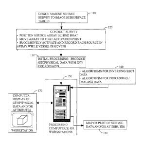
[0023] Figure 1 illustrates a general processing environment.
[0024] Figure 2 contains an operating logic suitable for use with an
embodiment.
[0025] Figure 3 illustrates an example marine environment of an embodiment.
[0026] Figure 4 contains an operating logic suitable for use with an
embodiment.
[0027] Figure 5 illustrates a prior art approach to source activations using
an array of marine
seismic sources.
[0028] Figure 6 illustrates an advantage of an embodiment.
[0029] Figures 7A and 7B illustrates an embodiment wherein individual sources
in an array
are sequentially activated (7A) and subarrays are activated (7B) at the same
location on the
surface of the earth.
[0030] Figure 8 contains a schematic that illustrates how an effective array
length may be
created that is longer than the actual array length.
[0031] Figure 9 illustrates an array with three subarrays that can be utilized
according to an
embodiment.
[0032] Figure 10 contains an illustration of a boat / source configuration
that can be used to
create an enhanced cross-line spatial sampling.
7
DETAILED DESCRIPTION
[0033] While the teachings that follow are susceptible of embodiment in many
different
forms, there is shown in the drawings, and will herein be described
hereinafter in detail, some
specific embodiments. It should be understood, however, that the present
disclosure is to be
considered an exemplification of the principles taught herein and is not
intended to limit the
claims to the specific embodiments or algorithms so described.
EMBODIMENTS
[00341 According to an embodiment, there is provided a method of marine
seismic
acquisition that allows more seismic sources to be utilized than would
otherwise be possible
in a conventional / single sub-array configuration. It should be noted that
additional
descriptions of some aspects of an embodiment may be obtained by reference to
U.S. Patent
Application Serial No. 13/315,947, US 2012/0147701 A2, the "Popcorn Patent
application".
100351 Popcorn shooting has many advantages, but one of particular interest
for purposes of
this disclosure is that it may be used to control or shape the spatial
sampling of seismic data.
This sampling may be improved with the use of simultaneous source acquisition,
or with the
use of the combination of simultaneous source acquisition and Popcorn
technology. With
this improved resolution comes a new flexibility in designing and creating
source arrays.
[0036] Self-simultaneous sourcing is a method of increasing the shot spatial
sampling density
of a seismic survey without slowing down the speed of the shooting boat. A
typical self-
simultaneous shooting example would be shooting at half the time interval of a
conventional
survey, where each shot is comprised of some number of sources filed
simultaneously. This
will cause the shot records to overlap each other in time which is generally
avoided in seismic
acquisition. However, overlapping shots can then separated during subsequent
processing
according to methods well known to those of ordinary skill in the art (e.g.,
by using inversion
or, more specifically, in some embodiments by sparse inversion).
[0037] Popcorn shooting, the practice of shooting individual air guns within
an array over a
period of time instead of the conventional simultaneous firing of multiple
guns, may be
considered as an extreme form of self-simultaneous shooting. One application
of Popcorn
shooting is continuous Popcorn, that is, the continuous firing of air guns
while the boat is
moving. Processing continuous Popcorn in some embodiments involves choosing a
shot
8
Date Recue/Date Received 2020-06-24
point interval, collecting all of the seismic traces that record air gun
firings that occurred at
surface locations defined by the chosen shot point interval, and separating
the collected traces
that contain overlapping shots using a combination of Popcorn reconstruction
and shot
separation by inversion as described in the first shot separation by inversion
U.S. Patent No.
8,559,270.
[0038] Note that in the Popcorn processing sequence for continuous Popcorn
shooting there
may likely be no natural shot point interval. Since source activations in some
Popcorn
embodiments are continuously (and even randomly) occurring, source activations
will not
likely be situated at regularly spaced surface locations, as is the case with
conventional
seismic acquisition. As a consequence, in this embodiment the shot point
interval is a
processing parameter, which may be varied as needed. For example, the shot
point interval
may be set to a small value for shallow, high-resolution surveys where the
small shot interval
is needed. For deeper targets, the shot point interval may be set to a large
value to allow
more air guns to contribute to each effective shot. The smallest shot point
interval may be set
to something that is less than a typical interval between air gun firing
positions since the shot
separation by inversion method can interpolate shots as needed. In each of
these cases,
seismic traces that record source activations at the chosen locations will be
identified,
separated from overlapping shots (if needed), and then used in subsequent
processing as is
described more fully below.
[0039] The method above creates shot arrays that are approximately the length
of the shot
point interval desired. The array length might also be increased by grouping
overlapping air
gun firings to create the same number of calculated shots with the shots
containing individual
firings of air guns that are shared between shots.
[0040] An alternative to the above method of creating arrays is to separate
all the individual
air gun firings and then to create arrays from the individual firings. This
might be done with
simple summations, weighted summations, or by beam-steering the individual
traces from
each air gun firing. Of course, the limiting case would be to not create
arrays, that is, to
process the traces from the individual air gun firings. This would provide the
best spatial
resolution but might allow more noise in the traces that would be otherwise
reduced by
forming arrays.
[0041] Since in this embodiment the shot point interval is now a post-
acquisition processing
parameter rather than an acquisition-set value, optimal shot point intervals
may be chosen for
9
Date Recue/Date Received 2020-06-24
CA 02939362 2016-08-11
WO 2015/138923
PCT/US2015/020477
various purposes. That is, conventionally the shot point interval is a pre-
acquisition design
decision that controls the collection of seismic data in the field, whereas in
this embodiment
the shot point interval can be specified for processing purposes post-
acquisition which means
that parameter may be chosen to be different values depending, as an example,
on the
subsurface target that is to be imaged. While typically two processing flows
would be used
to create seismic images from continuous Popcorn acquisition, one flow for
high-resolution
shallow images and one flow for deep depth images, it may be imagined that a
time-variant
processing flow could be used to simultaneously obtain a shallow high-
resolution image
while also creating images using large arrays to better image the deep
section.
[0042] This use of Popcorn shooting allows considerable flexibility in
creating arrays and
controlling resolution and pre-stack noise.
[0043] This embodiment frees the desired and ideal array length from the
physical
dimensions of the array. In an embodiment, if the Popcorn method is used, then
each gun is
fired separately in a pattern of N seconds and is separated from the signals
from overlapping
guns by the Popcorn or other inversion / separation method. Thus, in this
embodiment each
individual gun acts as a point source, regardless of the spatial arrangement
of the guns behind
the seismic vessel.
[0044] The instant approach is configurable in a variety of different ways.
Common to each
variation, though, is that the individual source activations that overlap will
need to be
numerically separated. Among the methods that might be used are inversion and,
in some
embodiments, sparse inversion as those terms are known and used in the seismic
processing
arts. Among the approaches that might be employed in various embodiments are:
I. The signal
from each seismic source in the array can be processed individually to
increase spatial sampling density. This approach provides a great deal of
flexibility
since once the individual guns have been separated, digital array forming may
be used
to create any desired array, or, in some embodiments, the sources may be
maintained
as point sources.
2. Each gun can
be activated in the same location as a forward gun was activated then
later reconstituted as a point and summed source. That is, in this approach it
will be
possible to make all of the guns in the array fire at the same location by
scheduling
the firing times to do so. The leading gun in the array / subarray (i.e., the
source
closest to the towing vessel) can be fired at a particular location and then
subsequent
sources can be fired as they are towed to that same location. Alternatively, a
similar
CA 02939362 2016-08-11
WO 2015/138923
PCT/US2015/020477
result may be obtained by modifying the firing times slightly so that an array
that is
shorter than the actual physical array may be constructed. Separation of the
overlapping shots can then be done using inversion or a similar technique.
3. A physically
short array can be digitally lengthened if the guns on the array are shot
back to front. That is, this variation allows a short array to be lengthened
by
scheduling the firing times of the individual guns to be spread out over a
distance that
is longer than the physical array. Typically this would involve firing the
guns from
the back of the physical array to the front, but the length of the constructed
array may
be more strongly affected by the firing times than the actual location of the
air gun on
the physical array.
[0045] The method discussed in previous paragraphs addresses the in-line shot
point interval
size. The use of Popcorn shooting may also improve the sampling in other
directions. Air
guns may be distributed along the cross-line direction and shot with Popcorn
patterns. The
resulting seismic signals may then be processed to appear as a single shot
that has been taken
with a large cross-line array or as separate shots with different cross-line
positions.
Intermediate cross-line samplings may also be formed.
[0046] A certain amount of care must be taken in the design of the Popcorn
patterns to ensure
that the sampling in the in-line or in the cross-line directions allow for
effective
reconstruction of shots in those directions. For example, the best
reconstruction of the shots
for a particular sampling will ensure that most of the shots being constructed
will have
physical shots contributing to them, and the distribution of these shots might
best be
somewhat uniform over the constructed shots. If one shot spacing is expected,
the Popcorn
patterns may be designed to provide the best separation of the shots at that
spacing.
[0047] Turning now to Figure 1, this figure contains a general overview of an
embodiment
and its associated environment. As is indicated, generally speaking a marine
seismic survey
will be designed 100 in a way that anticipates the use of the teachings
presented herein
during acquisition. That means, as a specific example, an array (or some
number of sub-
arrays) will be selected together with two or more seismic sources that are to
be towed behind
the source boat. Those of ordinary skill in the art will understand how such
is done and
especially how such is done where the object is to image a particular
subsurface target.
[0048] In the field, seismic data will be collected according to an embodiment
(block 120).
As is taught herein, individual sources within the array will be activated and
recorded
pursuant to the survey design 100 while the vessel is in motion. It is
anticipated that the vast
11
CA 02939362 2016-08-11
WO 2015/138923
PCT/US2015/020477
majority of source activations will over lap (or be overlapped by) one or more
activations. In
some instances, the receivers will be sensors that are towed behind the source
or another
vessel. In other cases, the receivers might include ocean bottom receivers
instead of (or in
addition to) the towed geophone streamers.
[0049] Next, and as is conventionally done, some initial processing will be
performed to
associate each seismic recording with a surface or other location (block 130).
This might be
done in the field or in the processing center. In either case, a computer
system 150, which
might be a workstation, a server, a main frame, a parallel computer, a
networked collection of
computers or workstations, etc.
[0050] Next, the individual source activations will be identified and
separated according to
methods well known to those of ordinary skill in the art (e.g., via sparse
inversion).
Algorithms that do such a separation will typically be made available to a
computer that is to
utilize them via access to some amount of local or remote hard disk or other
storage (item
140). Additional algorithms useful in the processing of seismic data will be
similarly
provided to the CPU 150 which might be any conventional or unconventional
programmable
computing device.
[0051] Following identification and separation of the different seismic source
recordings, the
data will be processed as has been generally discussed above depending on the
survey design.
In some instances the now-separated source activations might be combined in
different ways
to produce the same effect as a simultaneous excitation of the array, combined
to focus the
array to emphasize reflectivity from a particular target (e.g., via beam
steering). The
resulting data records will be seismic records that are comparable to those
conventionally
recorded by other methods.
[0052] Conventional usage of the separated and possibly recombined shot
records might be
used in any number of ways. Conventionally, the seismic data will be processed
and viewed
on a computer display such as that of a workstation 170. Output from the
seismic processing
may be used to create maps or plots of seismic data and/or seismic attributes
180 according to
methods well known to those of ordinary skill in the art.
[0053] Figure 2 contains additional details of a typical seismic processing
sequence that
might begin with data collection according to an embodiment 210, editing 215,
some sort of
initial processing 220, conditioning of the signal and imaging 230, production
of imaged
sections or volumes 240, initial interpretation of the seismic data 250,
further image
enhancement consistent with the exploration objectives 260, generation of
attributes from the
12
CA 02939362 2016-08-11
WO 2015/138923
PCT/US2015/020477
processed seismic data 270, reinterpretation of the seismic data as needed
280, and ultimately
generation of a drilling prospect 290.
[0054] Figure 3 contains another illustration of an embodiment as it might be
practiced. In
an embodiment, one or more seismic vessels 310 will tow some number of
receiver sensors
332 in a body of water 320. Additionally, at least one of the vessels 310 will
tow an array
330 of seismic sources 340 and 350. Note that the sources 340 350 in the array
330 need
not be the same size / capacity! frequency range and could possibly be towed
at different
depths. On the other hand, the sources 340 / 350 in the array could all be of
the same size!
capacity! frequency range and the fact that different sizes of icons were used
should not be
construed to limit the instant teachings to only those arrays with sources of
different sizes. In
some embodiments, additional receivers 335 (e.g., ocean bottom receivers) will
be situated on
the ocean floor 325. A principal object, of course, is to obtain an image of
the subsurface
configuration 324.
[0055] Figure 4 contains a sample operating logic suitable for use with an
embodiment. As
an initial matter a marine survey will be designed 405. Typically, this will
be with the object
of imaging a particular subsurface feature or region. In connection with such
design, will be
the specification of the sources that are to comprise the array that is towed
over the survey
area (block 410). Additionally, and in some embodiments this will be done
during the design
of the survey, the sources in the array will be subdivided into two or more
subarrays. In some
embodiments each source will be assigned to only one subarray. In other
instances, one or
more sources could be assigned to more than one subarray. The sources might be
different
sizes and have different frequency characteristics, etc. They might also be
towed at the same
depth or at different depths. It is critical that at least two different
sources (which might or
might not have similar properties) be in the array and that the array be
divided into at least
two different subarrays. Sources that might be appropriate would include some
combination
of air guns, water guns, sparkers, boomers, chip systems, water sirens, marine
vibroseis, non-
impulsive marine sources, etc.
[0056] In addition to the selection of the seismic array and/or in conjunction
with such
selection, will be the specification of how the array is to be divided into
subarrays. In some
embodiments some of the subarrays might consist of a single seismic source. In
other
embodiments, some subarrays might comprise two or more sources.
13
[0057] Next, a firing schedule will be developed for use with each of the
subarrays (block
415). Each firing schedule will apply to each of the one or more sources in
each subarray and
at least two of such schedules must be different. That is,
[0058] As an example, in Figure 3 each of the individual sources 340 and 350
in the array
might get its own firing schedule, independent of the others. As another
example, the sources
of Figure 3 might be grouped into two subarrays and only two firing schedules
would then
need to be developed: one for sources 340 and another for sources 350. Those
of ordinary
skill in the art will readily be able to devise different combinations of
sources, subarrays, and
firing schedules that would be consistent with the instant disclosure.
[0059] The reconstruction of signals from Popcorn acquisition will depend on
the air gun
patterns used to acquire a Popcorn-type survey. Poorly designed patterns
reduce the accuracy
of the reconstructions, while well designed patterns improve it. By way of
example, a first
way of designing a Popcorn-type survey utilizes a Monte-Carlo approach where
many
random patterns are generated and then checked against a set of criteria to
get the best
patterns. Another example method would be to design the patterns analytically.
Various
aspects of approaches for designing firing schedules may be found in co-
pending U.S. Patent
application serial nos. 13/315,947, and, 61/903,587.
[00601 Returning now to Figure 4, next, one or more seismic boats will be
dispatched to the
survey area and the survey will begin (block 420). In addition to the source
boat, additional
boats might be present to tow streamers with seismic sensors. For example, it
is known to
have additional streamer boats if a wide azimuth survey is desired.
Additionally, and as is
generally indicated in Figure 3, in some cases ocean bottom receivers might be
used in
conjunction with or instead of marine seismic streamers.
[0061] Next, a continuous or intermittent recording will be initiated and each
source (or
source group) will be activated according to its predetermined schedule (block
425). That
being said, continuous recording would generally be favored, although not
required. It is
anticipated that generally the source activation schedules will cause the
signals sourced from
different firing schedules to overlap. As such, it is further anticipated that
the source
activations will need to be separated thereafter using, for example, sparse
inversion according
to methods well known to those of ordinary skill in the art.
[0062] In one embodiment after acquisition, each seismic data record will
contain multiple
source activations that will need to be separated or otherwise processed as a
prerequisite to
14
Date Recue/Date Received 2020-06-24
CA 02939362 2016-08-11
WO 2015/138923
PCT/US2015/020477
further seismic processing. For purposes of the instant disclosure, the term
"reconstruction"
should be understood to mean the processing step(s) necessary to convert
traces collected
during a Popcorn survey of the sort taught herein into more conventional
seismic traces.
[0063] In one embodiment the recorded seismic data "d" (which might be, for
example, a
common offset or common receiver gather) can be related to the desired
unblended /
reconstructed source activations "m" through the following matrix equation:
d = Am,
where M is, broadly speaking, representative of the seismic data that would
have been
obtained from a more conventional seismic survey without simultaneous sourcing
or
Popcorn-type shooting, and where, "A" is a matrix that describes the
convolution of the
various Popcorn signatures onto in, where a "Popcorn signature" is the
composite signature
that is formed when the sources in a set are activated according to a
specified firing schedule.
In other words, each row of A can be thought of as a time-shifted composite
source signature.
In some embodiments, a coherency condition ("C") might also be applied (e.g.,
the shot at
one surface location will tend to resemble the shots at proximate locations,
etc.):
d = ACm.
[00641 Since the matrix A is likely to be underdetermined, in some embodiments
an iterative
approach could be used to obtain d. One method of solving for d would be as
follows;
Set M = 0;
Set destimatett ¨ 0
Calculation loop:
Ad ¨ d - destimated
AM = Ad
m = in + Am,
apply coherency filter to in
destimated= A M
Recalculate Ad, etc. until the answer is satisfactory. As is indicated above,
in an embodiment
an FK transform, FX deconvolution, Radon transform, etc., might be used as a
coherency
filter to attenuate incoherent energy. In some applications, the transform
might be applied to
a common offset or common receiver gather by taking the FK transform and
discarding (e.g.,
setting to zero) all values below a particular threshold value. Those of
ordinary skill in the art
will understand that the particular parameter values that control the
coherency filter might
need to be selected based on experience and/or on a trial and error basis, but
selection of
CA 02939362 2016-08-11
WO 2015/138923
PCT/US2015/020477
same is well within the skill of one who practices in this field. The
selection of the coherency
processing parameters might depend on quality of the recorded seismic data,
the Popcorn
patterns utilized, the array size, sources used, etc.
[0065] Continuous Popcorn allows the shot spacing to be a processing
parameter, but
continuous Popcorn may also involve a significant element of simultaneous
shooting and
subsequent separation of the overlapping source activations (block 430). That
being said, in
many embodiments self-simultaneous shooting will not be desired and, in such
case, the data
will not need to be separated and reconstruction can proceed as is discussed
supra.
[0066] Next, the now-separated source activations will be further processed as
has been
described previously (block 435) to produce subsurface images.
[0067] Finally, the seismic sections, attribute analyses, etc., will be
available for use in
prospect generation, subsurface interpretation, etc. (block 440).
[0068] Turning next to Figure 5, this figure illustrates a conventional
approach to using a
source array in a marine setting. In this case, each of the sources 540 in the
array will be
activated simultaneously which will result in a single recorded activation
(represented
schematically by the up going ray 505). Because all of the sources 540 are
activated
simultaneously the six reflecting points associated with the six source
activations are smeared
and treated as if the acoustic energy had been emitted from the geometric
center of the array
(i.e., between guns 3 and 4 which is schematically represented by the origin
of the up going
ray 505). This lateral smearing, of course, introduces certain inaccuracies
into the subsurface
image that is collected by the conventional method. It should be noted and
remembered that
the sources 540 might all be the same size, frequency content, etc., or they
might be differ in
size, frequency content, etc. depending on the needs of the particular survey.
[0069] On the other hand, if the six guns 540 are fired separately and not
simultaneously
(Figure 6), the six guns can be reconstituted as a single shot comparable to
the arrangement
of Figure 5, or reconstituted as six separate shots, thereby increasing the
spatial sampling by a
factor of six. In this case, each of the guns will generate its own up going
wave field 605
which can be extracted, separately processed and combined (or not) with other
source
activations from this array. In an alternative arrangement, some of the guns,
say the first
three could be formed into one group and the last three into another, with the
sources in each
group being activated simultaneously. This would produce two different
"sources" that could
then be combined and/or processed separately.
16
CA 02939362 2016-08-11
WO 2015/138923
PCT/US2015/020477
[0070] Note that the previous observation means that popcorn shots from
individual guns
could be used to reconstruct a signal comparable to the one that would have
been obtained if
every source in the array had been activated at the same point on the
subsurface. In the
arrangement of Figure 7A, and as an example a vessel 320 is pictured as towing
a 6 gun 720
array 710. Note that although the graphic icons used to represent the guns in
the array 710
are all the same size, that should not be used to infer that, in practice, the
guns would all be
the same size, towed at the same depth, have the same frequency content or
other properties.
Instead, it should be understood and remembered that the guns 710 might be any
size, towed
at any depth, etc.
[0071] In this figure, the same vessel 310 is shown at intervals of 1 second
as it moves
through the water toward the right hand side of the figure. In this
embodiment, each
individual source 720 is activated in turn at the same location as it is
pulled over that location.
The source that is activated is indicated by the arrow 710. Thus, in this
figure if the vessel
310 is sailing at 4.86 knots (2.5 m/s) and the inline spacing of the guns 720
is 2.5 m, and the
guns are separately shot at 1 second intervals beginning with the forward gun
(i.e., the gun
closest the towing vessel 310), followed by the second gun, and so on, each of
the 6 guns 720
will fired proximate to the same location on the surface of the earth. If the
6 guns' shots are
thereafter reconstituted and summed as a single shot, the effective array
length is zero,
despite the fact that the physical array length in this example is 12.5 m.
Similarly, in Figure
7B subarrays (pairs of sources 710 are sequentially activated such that each
source pair is
fired at the same location. As might be expected, in both Figure 7A and 7B the
recorded
subsurface reflections from the shots will overlap in time and need to be
separated before
being further processed to image the subsurface.
[0072] On the other hand and turning next to the example of Figure 8, this
figure illustrates
how the same towed array 710 can be used according to create an effectively
stretched
source. That is, as an example a virtual source array can be created that is
longer than the
actual array. In this example, a vessel 310 is towing a 6 gun 720 array 710.
As before, the
vessel 310 of Figure 8 is shown at intervals of 1 second as the array 710 is
towed through the
water. If the vessel is sailing at 4.86 knots (2.5 m/s) and the inline spacing
of the guns is 2.5
m, and the guns 720 are activated at 1 second intervals beginning with the gun
most distant
from the vessel, followed by the gun second most distant, etc., when the 6
guns' shots are
reconstituted and summed together as a single shot, the effective array length
will be 25 m,
rather than the physical array length of 12.5 m.
17
CA 02939362 2016-08-11
WO 2015/138923
PCT/US2015/020477
[0073] Turning next to the example of Figure 9, in this case the vessel 310 is
towing an 18-
gun array 910 which consists of three subarrays of six guns each. In a
conventional survey,
all 18 of the guns would be fired simultaneously and processed as a single
seismic shot which
would be then be considered to have been located roughly at the geometrical
center of the
array. That being said, in some cases the location of the shot might be
determined based on
the energy or pressure, etc. But, in any case, the shot when this array 910 is
simultaneously
activated will be considered to have taken place at a position that is a
compromise value
based on the number and positions of the guns in the array / subarray.
[0074] According to an embodiment, most or all of the guns are not fired
simultaneously, but
sequentially in patterns that meet various numerical and geophysical criteria.
For example, a
popcorn pattern may require the guns to be discharged in the order: 2, 9, 16,
1, 10, 14, 6, 8,
12, 17,7, 16,4, 11, 15, 13, 5, 3. A pattern may be constructed so that a given
gun might be
used more than once in a pattern, or not at all although, typically, each gun
would be used
once each time the pattern was employed. In the popcorn method, the seismic
data recorded
from the discharged guns can be reconstructed to a single point, such as the
geometrical
center. Or the seismic data from each individual gun can be positioned at the
location of that
gun when it was discharged. Or the seismic data from a group or subgroup of
guns can be
reconstituted, or treated, as a single shot. For example, guns 1-6 could be
treated as a single
shot; similarly guns 7-12 and 13-18, or guns 1,7, 13 could be grouped,
followed temporally
by a group composed of 2,8,14, followed temporally be 3,9,15, and so on. Or
6,12,18 could
be followed by 5,11,17, etc. Guns can be shot in the location of a previously
discharged gun,
or not. The patterns can be designed so that the sequence provides an acoustic
beam steer in
a given azimuth. Therefore, the methods disclosed herein provide great
flexibility in
choosing the resulting source array lengths and distance between shots
(spatial sampling).
[0075] Finally, turning next to Figure 10, this embodiment contains an example
of how
crossline spatial sampling might be implemented. In this case, the airguns 720
might be
spread by means of paravanes (or other means) according to methods well know
to those of
ordinary skill in the art. Each airgun, when repeatedly discharged, will
generate a number of
CMP (i.e., common mid-point) lines equal to the number of seismic receiver
lines. Since
each CMP line will be separated by half the distance between the guns, the
number of CMP
lines generated will be 17x greater (in this example) than if all the guns
were discharged
simultaneously and conventionally. Or the data could be reconstituted as a
single shot with a
large areal extent.
18
[0076] Additional details related to the simultaneous source and self-
simultaneous source
methods may be found in one or more of the following references:
U.S. Patent Application serial no. 12/542,433 (BP docket 39397; Method For
Separating Independent Simultaneous Sources/ USSN), U.S. Patent Application
serial no.
61/154,613 (BP docket 39467; Separation Of Simultaneous Seismic Sources By Non-
Linear
Inversion/Abandoned USSN), and U.S. Patent Application serial no. 13/315,925
(BP docket
40082; Distance-And Frequency-Separated Swept-Frequency Seismic Sources).
[0077] Further, where reference is made herein to a method comprising two or
more defined
steps, the defined steps can be carried out in any order or simultaneously
(except where
context excludes that possibility), and the method can also include one or
more other steps
which are carried out before any of the defined steps, between two of the
defined steps, or
after all of the defined steps (except where context excludes that
possibility).
[0078] Still further, when in this document a range is given as "(a first
number) to (a second
number)" or "(a first number) ¨ (a second number)", this means a range whose
lower limit is
the first number and whose upper limit is the second number. For example, 25
to 100 should
be interpreted to mean a range whose lower limit is 25 and whose upper limit
is 100.
Additionally, it should be noted that where a range is given, every possible
subrange or
interval within that range is also specifically intended unless the context
indicates to the
contrary. For example, if the specification indicates a range of 25 to 100
such range is also
intended to include subranges such as 26-100, 27-100, etc., 25-99, 25-98,
etc., as well as any
other possible combination of lower and upper values within the stated range,
e.g., 33-47, 60-
97, 41-45, 28-96, etc. Note that integer range values have been used in this
paragraph for
purposes of illustration only and decimal and fractional values (e.g., 46.7 ¨
91.3) should also
be understood to be intended as possible subrange endpoints unless
specifically excluded.
[0079] The term "at least" followed by a number is used herein to denote the
start of a range
beginning with that number (which may be a ranger having an upper limit or no
upper limit,
depending on the variable being defined). For example, "at least 1" means 1 or
more than 1.
The term "at most" followed by a number is used herein to denote the end of a
range ending
with that number (which may be a range having 1 or 0 as its lower limit, or a
range having no
lower limit, depending upon the variable being defined). For example, "at most
4" means 4
or less than 4, and "at most 40%" means 40% or less than 40%. Terms of
approximation
(e.g., "about", "substantially", "approximately", etc.) should be interpreted
according to their
19
Date Recue/Date Received 2020-06-24
CA 02939362 2016-08-11
WO 2015/138923
PCT/US2015/020477
ordinary and customary meanings as used in the associated art unless indicated
otherwise.
Absent a specific definition and absent ordinary and customary usage in the
associated art,
such terms should be interpreted to be 10% of the base value.
[0080] It should be noted that in the foregoing, the discussion has been
largely couched in
terms of conventional marine seismic surveys, but that was done for purposes
of illustration
only and not out of an intent to limit the disclosure presented herein to only
those sorts of
surveys. Those of ordinary skill in the art will understand how the
embodiments presented
supra could readily be applied, by way of example only, to 2D, 3D, 4D, etc.,
marine surveys,
down hole surveys, VSPs, or any combination of same.
[0081] Although the instant disclosure might have described the seismic
sources as "guns",
"airguns", etc., that was done only for purpose of illustration and any marine
source
including, without limitation, air guns, water guns, sparkers, boomers, chirp
systems, water
sirens, etc., might potentially be used. Additionally, as noted previously
aspects of the instant
disclosure could be applied on land as well. Further, instances where the term
"shot" was
used herein should not be construed to limit the instant disclosure to only
operating with
impulsive sources. Thus, when the term "seismic survey" is used herein that
term should be
understood to apply to a survey on water, land, or any combination of same
unless
specifically indicated otherwise.
[0082] While this invention is susceptible of embodiment in many different
forms, there is
shown in the drawings, and is herein described in detail, some specific
embodiments. It
should be understood, however, that the present disclosure is to be considered
an
exemplification of the principles of the invention and is not intended to
limit it to the specific
embodiments or algorithms so described. Those of ordinary skill in the art
will be able to
make various changes and further modifications, apart from those shown or
suggested herein,
without departing from the spirit of the inventive concept, the scope of which
is to be
determined by the following claims.