Note: Descriptions are shown in the official language in which they were submitted.
CA 2940191 2017-03-22
1
GEOSTEERING SYSTEMS AND METHODS THEREOF
FIELD OF THE DISCLOSURE
[0002] The present disclosure relates, in some embodiments, to methods and
systems of
geosteering or geological operations. More specifically, some embodiments may
provide for
vittualization of data in the horizontal and/or vertical directions.
BACKGROUND OF THE DISCLOSURE
[0003] Subsurface rock formations may generally comprise vertical stackings
of various rock
strata or rock formations. Each layer of rock formation may have unique
characteristics. Some layers
of rock formations may be oil-gas productive. Wellbores may be drilled through
subsurface rock
formations to reach oil-gas productive layers so that, among other purposes,
materials such as oil and
gas may be extracted. In some circumstances, horizontal drilling may
advantageously allow for greater
productivity in the extraction of oil and gas.
[00041 However, fluctuations in the vertical stacking of various rock
strata or rock formations
may present difficulties in navigating a wellbore such that the wellbore is
maintained in a desired
stratigraphic interval or layer. For example, formation dips, or the angle of
tilt of a stratigraphic
interval, may require that a trajectory of a wellbore be continuously
adjusted. One of ordinary skill in
the art would appreciate that various rock strata or rock formations may or
may not be orderly
arranged. Thus, certain rock strata may exhibit angles of tilt, sometimes over
distances of hundreds or
thousands of horizontal feet across a surface.
[0005] Various geosteering techniques may be utilized to help ensure that
horizontal wellbores
are positioned in a desired stratigraphic interval. Wellbores may be better
steered or positioned when
practitioners have more accurate data or virtualization of the geological
formations in a relevant
subsurface region. Absent such accurate data, practitioners may
CA 02940191 2016-08-25
WO 2015/130836
PCT/US2015/017591
2
have to rely on broad and potentially imprecise guesses or estimations. More
accurate data or
virtualizations may be desirable in both the horizontal and vertical
directions.
CA 02940191 2016-08-25
WO 2015/130836 PCT/ll
S2015/017591
3
SUMMARY
[0006] Accordingly,
a need has arisen for improved methods and systems of
geosteering to provide for more accurate data and/or virtualizations in the
horizontal and/or
vertical directions.
[0007] The present
disclosure relates, in some embodiments, to methods and systems
of geosteering or geological operations. More specifically, some embodiments
may provide
for virtualizations of vertical logs into pseudo-horizontal data. Such
embodiments may
provide for improved or more accurate data and/or virtualizations in the
horizontal and/or
vertical directions. In some embodiments, systems of the present disclosure
may transmit
MWD or LWD data to a processor. The processor may extrapolate and convert the
MWD or
LWD data into KBTVD or pseudo-vertical data. Said extrapolation may be
performed based
on algorithmic expressions between the True Vertical Depth, the formation dip
angle, and a
Vertical Section Distance. In some embodiments, vertical data may be
extrapolated by a
processor and converted into pseudo-horizontal data. In some embodiments,
systems may
evaluate the formation dip angle and extrapolate a corrected true thickness of
an interval
layer. Screen representations of aforementioned data may be provided through a
user
interface device.
[0008] Methods for
geosteering according to the present disclosure may comprise
collecting, by at least one down-hole sensor associated with a wellbore,
empirical measure-
while-drilling data while drilling a subsurface well. Methods may further
comprise storing,
by a non-transitory computer readable storage medium in communication with the
at least
one down-hole sensor, the collected empirical measure-while-drilling data.
Methods may
further comprise deteimining, by a processor in communication with the non-
transitory
computer readable storage medium, a calculated vertical-log, wherein the
calculated vertical-
log is extrapolated at least in part based on the empirical measure-while-
drilling data, and
wherein the calculated vertical-log is reflective of stratigraphy along a
substantially vertical
direction. Methods may further comprise determining, by the processor, a
calculated
horizontal-log, wherein the calculated horizontal-log is extrapolated at least
in part based on
the calculated vertical-log, wherein the calculated horizontal-log is
reflective of stratigraphy
along a substantially horizontal direction, and wherein the calculated
horizontal-log provides
for horizontal-foot-to-vertical-foot equivalence.
[0009] In some
embodiments, methods may further comprise presenting, by a display
device in communication with the processor, a graph of the empirical measure-
while drilling
data and a graph of the calculated horizontal-log. In some embodiments,
methods may further
CA 02940191 2016-08-25
WO 2015/130836
PCT/US2015/017591
4
comprise presenting, by a display device in communication with the processor,
a graph of
both the empirical measure-while drilling data and the calculated horizontal-
log. The graph of
the empirical measure-while drilling data may be presented adjacent to the
graph of the
calculated horizontal-log.
[0010] Methods may
further comprise adjusting a drilling path of the wellbore based at
least in part on the calculated horizontal-log. Methods may further comprise
determining a
calculated vertical-log is based at least in part on a true vertical depth, a
formation dip angle,
and a vertical section distance. Methods may further comprise receiving an
input, wherein the
input provides an adjusted thickness value for a stratigraphic layer along the
substantially
vertical direction. Methods may further comprise determining, by the
processor, an adjusted
horizontal-log, wherein the adjusted horizontal-log is extrapolated at least
in part based on the
adjusted thickness value. Methods may further comprise presenting, by a
display device, a
graph of the adjusted horizontal-log.
[0011] The present
disclosure also provides for systems of geosteering. Systems of
geosteering may advantageously be configured to perform the aforementioned
methods. In
some embodiments, systems may comprise at least one down-hole sensor, the at
least one
down-hole sensor configured to collect empirical measure-while-drilling data
while drilling a
subsurface well. In some embodiments, systems may comprise a non-transitory
computer
readable storage medium, wherein the non-transitory computer readable storage
medium is in
communication with the at least one down-hole sensor, and wherein the non-
transitory
computer readable storage medium configured to store the collected empirical
measure-
while-drilling data. Systems may further comprise a processor in communication
with the
non-transitory computer readable storage medium, the processor configured to
determine a
calculated vertical-log and a calculated horizontal log.
[0012] The
calculated vertical-log may be extrapolated at least in part based on the
empirical measure-while-drilling data. The calculated vertical-log may be
reflective of
stratigraphy along a substantially vertical direction. The calculated
horizontal-log may be
extrapolated at least in part based on the calculated vertical-log. The
calculated horizontal-log
may be reflective of stratigraphy along a substantially horizontal direction.
The calculated
horizontal-log provides for horizontal-foot-to-vertical-foot equivalence.
CA 2940191 2017-03-22
BRIEF DESCRIPTION OF THE DRAWINGS
[0014] Some embodiments of the disclosure may be understood by referring,
in part, to the
present disclosure and the accompanying drawings, wherein:
[0015] FIGURE 1A illustrates an example wellpath through a stratigraphic
interval;
[0016] FIGURE 1B illustrates an example wellpath through a stratigraphic
interval;
[0017] FIGURE 1C illustrates an example wellpath through a stratigraphic
interval;
[0018] FIGURE 1D illustrates an example wellpath through a stratigraphic
interval;
[0019] FIGURE 2A illustrates various formation dip models applied to a
stratigraphic interval;
10020] FIGURE 28 illustrates an example incorrect formation dip model
angle;
[0021] FIGURE 2C illustrates an example incorrect formation dip model
angle;
[0022] FIGURE 2D illustrates an example correct formation dip model angle;
[0023] FIGURE 2E illustrates an example diagram of extrapolation KBTVD or
pseudo-vertical
data;
[0024] FIGURE 2F illustrates a screen representation of an example
embodiment of the present
disclosure;
100251 FIGURE 2G illustrates a screen representation of an example
embodiment of the present
disclosure;
[0026] FIGURE 3 illustrates a example system of the present disclosure;
[0027] FIGURE 4 illustrates a example system of the present disclosure;
[0028] FIGURE 5 illustrates a screen representation of an example
embodiment of the present
disclosure;
[0029] FIGURE 6A illustrates an example wellpath through a stratigraphic
interval;
[0030] FIGURE 6B illustrates an example wellpath through a stratigraphic
interval; and
[0031] FIGURE 7 illustrates an example system of the present disclosure.
CA 02940191 2016-08-25
WO 2015/130836
PCT/US2015/017591
6
DETAILED DESCRIPTION
[0032] The present
disclosure relates, in some embodiments, to methods and systems
of geosteering or geological operations. More specifically, some embodiments
may provide
for virtualizations of vertical logs into pseudo-horizontal data. Such
embodiments may
provide for improved or more accurate data and/or virtualizations in the
horizontal and/or
vertical directions.
[0033] Embodiments
of the present disclosure may utilize empirical data to provide
virtualizations in the horizontal and/or vertical directions. Empirical data
used may include
Measure While Drilling ("MWD") or Log While Drilling ("LWD") data. MWD or LWD
data may refer to data that is collected in the wellbore and transmitted to a
processor or an
interface device at the surface while a deviated or horizontal well is being
drilled. MWD and
LWD data may refer to at least two categories or types of data. One category
or type may
comprise surveys, which may indicate or report the 3-dimensional positioning
of a wellbore.
Another type of MWD and LWD data may comprise log curves measuring various
rock strata
properties. Such log curves may advantageously be used to identify
characteristics of a
stratigraphic interval and may allow one to determine whether drilling is
occurring in the
target interval or whether the wellbore needs to be adjusted. Additionally or
alternatively,
such determinations may allow for one to assess the productivity of
stratigraphic intervals
and whether particular stratigraphic intervals are suitable for hydraulic
fracture treatments or
other extraction treatments. The two categories of MWD and LWD data described
here are
provided as examples only. MWD and LWD data may comprise other data acquired
while a
well is being drilled. Such empirical data may also be used without departing
from the scope
of the present disclosure.
[0034] In some
embodiments, the present disclosure may provide for digital
conversions of horizontal or near-horizontal MWD and LWD data into pseudo-
vertical log
views. For any given trajectory of a wellbore within a well, MWD and LWD data
may
suggest an apparent thickness of a particular stratigraphic interval. An
apparent thickness
may or may not be equivalent to or accurately reflect a true stratigraphic
thickness of a
particular interval. Whereas the true stratigraphic thickness may be the
actual thickness, the
apparent thickness may be a thickness as indicated or suggested by empirically
collected data.
Apparent interval thickness may be a function of a true stratigraphic
thickness, a formation
dip of the stratigraphic interval, and an angle of incidence of the wellbore.
[0035] An angle of
incidence of a wellbore may be referred to as an inclination. An
angle of incidence or inclination may refer to an angle of the wellbore with
respect to a
CA 02940191 2016-08-25
WO 2015/130836
PCT/US2015/017591
7
vertical axis. Such angle may generally be expressed in degrees. In some
conventions, a
wellbore directed straight down may be described as having an angle of
incidence or an
inclination of 0 degrees. A wellbore directed horizontally may be described as
having an
angle of incidence or an inclination of 90 degrees. Further, a wellbore
directed directly
upwards towards the surface along the vertical may be described as having an
angle of
incidence or an inclination of 180 degrees. Such conventions are provided for
example only.
Other conventions for denoting an angle of incidence or an inclination may be
used without
departing from the scope of the present disclosure.
[0036] The
functional relationship between an apparent interval thickness and a true
stratigraphic thickness is shown in FIGURES IA, IB, IC, and ID. Figure IA
depicts an
example wellpath through a stratigraphic interval 10A. As shown, the
trajectory or wellpath
12A of the wellbore through the target interval may be nearly perpendicular.
Logs collected
perpendicular to or near perpendicular to a stratigraphic layer may closely
represent the true
stratigraphic thickness 14A of the layer. Explained differently, logs
collected perpendicular
to a stratigraphic layer may roughly be equivalent to a vertical log.
Accordingly, the apparent
thickness 16A may be equivalent or substantially equivalent to the true
stratigraphic thickness
14A.
[0037] Figure 1B
depicts another example wellpath through a stratigraphic interval
10B. As shown in Figure 1B, the trajectory or wellpath 12B of the wellbore is
oblique to the
stratigraphic layer. Logs collected oblique to an interval may exaggerate the
interval
thickness and may not resemble a vertical type log and may not accurately
reflect the true
stratigraphic thickness 14B. As shown in Figure 1B, as a result of an oblique
angle of
incidence, an apparent thickness 16B may be stretched or may be substantially
exaggerated
and/or substantially greater as compared to the true stratigraphic thickness
14B.
[0038] Figure 1C
depicts yet another example wellpath through a stratigraphic
interval 10C. Similarly, in Figure 1C, the angle of incidence of the wellbore
may result in an
exaggerated or inaccurate apparent thickness 16C. As shown in Figure 1C, an
angle of
incidence in the well may be parallel or near parallel to the target interval.
In such
circumstances, the trajectory or wellpath 12C of the wellbore may approach a
"flat-line" or
may be parallel to the target interval. Accordingly, the apparent thickness
16C may be
significantly exaggerated or stretched, and may become theoretically
unlimited. Thus, the
apparent thickness 16C may be substantially exaggerated and/or substantially
greater as
compared to the true stratigraphic thickness 14C.
CA 02940191 2016-08-25
WO 2015/130836
PCT/US2015/017591
8
[0039] Figure 1D
depicts yet another example wellpath through a stratigraphic
interval 10D. As shown in Figure 1D, the trajectory or wellpath 12D of the
wellbore may
cross over a target interval multiple times. Described differently, a
wandering wellbore
trajectory may cross over target interval boundaries repeatedly. Logs
collected while
wandering sub-parallel to beddings or intervals may show thicknesses
exaggerated and bed
boundaries crossed multiple times. In such circumstances, the apparent
thickness 16D may
also be stretched or may otherwise be inaccurate relative to the true
stratigraphic thickness
14D.
[0040] As
described, an apparent interval thickness may be a function of a true
stratigraphic thickness, a formation dip of the stratigraphic interval, and an
angle of incidence
of the wellbore. Since an apparent interval thickness may be inaccurate and
may fail to
accurately reflect the true stratigraphic thickness, it may be advantageous to
calculate the true
thickness of a particular stratigraphic interval.
[0041] An angle of
incidence or an inclination may be known from MWD or LWD
data. An apparent thickness may be measured or otherwise collected from type
logs or MWD
or LWD data. Accordingly, such known data may be processed by a processor to
model
formation dips and/or resolve an angle of incidence. As a result, the relevant
formation dips
may be determined. Furthermore, the stratigraphic vertical component may be
deteimined
and presented on a display device as a pseudo-vertical log.
[0042] Pseudo-
vertical logs may also be referred to as Kelly Bushing True Vertical
Depth ("KBTVD"). KBTVD may refer to the True Vertical Depth (TVD) under the
Kelly
Bushing drilling rig. TVD may be the vertical depth of any point in a wellpath
below the
zero-depth datum. TVD may be determined or calculated irrespective of any
lateral
displacement out from under the drilling rig.
[0043] KBTVD may
refer to the depth of any point in a wellpath if projected back
under the drilling rig at a specified formation dip angle. KBTVD may be
expressed, for
example, as, ". . . 9500' under the rig, projected in at 92.0 degrees."
Described differently,
KBTVD may be a vector-derived depth under the drilling rig. KBTVD may be
advantageously applied as a way to correct TVD for the up-down influence of
formation dips
over a particular horizontal distance.
[0044] A horizontal
distance may be measured or calculated as the Vertical Section
Distance ("VSD"). VSD may be a calculated distance from a surface drilling
location to any
point in a horizontal wellpath, if said point is projected into the Vertical
Section Plane
perpendicular to the Vertical Section Plane Azimuth.
CA 02940191 2016-08-25
WO 2015/130836
PCT/US2015/017591
9
[0045] Vertical
Section Plane may refer to a hypothetical plane of vertical section, as
though the earth or stratigraphic formation had been sliced away by a vertical
cut through a
hypothetical line (direction), to an unspecified depth.
[0046] Vertical
Section Plane Azimuth may be the compass bearing azimuth of the
idealized Vertical Section Plane. In horizontal wells, it may usually be the
compass bearing
(0-359.99 degrees) from the surface drilling location to the terminus of the
horizontal well. It
may be a straight line, though not necessarily drilled. The Vertical Section
Plane Azimuth
may define the compass-bearing orientation of the Vertical Section Plane.
[0047] Depictions
of various embodiments of generating or extrapolating pseudo-
vertical logs or KBTVD are shown in FIGURES 2A, 2B, 2C, 2D, 2E, 2F, and 2G.
Diagram
100A of Figure 2A illustrates formation dip models applied to a stratigraphic
interval.
Referring to Figure 2A, various formation dip models for a particular wellpath
102A or
trajectory are displayed. Figure 2A depicts a visualization of a vertical type
log 112A.
Further, as shown in Figure 2A, a wellpath 102A may traverse upwards from the
base of an
interval to the top of an interval. Various formation dip angles may be used
to extrapolate the
true stratigraphic thickness of an interval. In Figure 2A, various formation
dip models 114A
are depicted using dashed lines at varying angles. Models and corresponding
calculations
may be based at least in part on the wellpath distance across a stratigraphic
layer section
110A. As shown, some founation dip models may result in inaccurate
calculations of true
stratigraphic thickness 104A. However, an accurate formation dip model may
determine a
true stratigraphic thickness 104A. Determination of a true stratigraphic
thickness may
advantageously provide for better understanding of characteristics of a well
and
advantageously allow for better geosteering of a wellbore.
[0048] Further
examples are depicted in Figure 2B, 2C, and 2D. Diagram 100B of
Figure 2B illustrates formation dip models applied to a stratigraphic
interval. Figure 2B
depicts a visualization of a vertical type log 112B and MWD log curve data
collected in a
lateral hole 116B. Further, as shown in Figure 2B, an incorrect formation dip
angle may
resolve MWD or LWD data into an incorrect or inaccurate pseudo-vertical
thickness. More
specifically, an incorrect formation dip angle as applied to modelling
formation 114B may
result in a model or extrapolation that may be offset and/or exaggerated, and
may not
accurately predict and./or correspond to a true stratigraphic thickness 104B.
[0049] Similarly,
diagram 100C of Figure 2C also depicts a situation where an
incorrect formation dip angle may resolve MWD or LWD data into an incorrect or
inaccurate
pseudo-vertical thickness. Figure 2C also depicts a visualization of a
vertical type log 112C
CA 02940191 2016-08-25
WO 2015/130836
PCT/US2015/017591
and MWD log curve data collected in a lateral hole 116C. Similar to Figure 2B,
the
modelling formation 114C in Figure 2C may also be inaccurate as a result of
incorrect
formation dip angle. Thus, the model or extrapolation may not accurately
predict and./or
correspond to a true stratigraphic thickness 104C.
[0050] In contrast,
diagram 100D of Figure 2D depicts an example of where MWD or
LWD log curve data may be resolved into a true stratigraphic thickness with
the correct
formation dip angle. Figure 2D also depicts a visualization of a vertical type
log 112D and
MWD log curve data collected in a lateral hole 116D. However, in Figure 2D, a
correct
formation dip angle may be applied and may thus result in an accurate
modelling formation
114D. Thus, the modelling formation 114D may accurately reflect the true
stratigraphic
thickness 114D.
[0051] Conversion
or extrapolation of horizontal or near horizontal MWD or LWD
data into pseudo-vertical data may be perfomied using various algorithms. In
some
embodiments, appropriate algorithms may be based on trigonometric functions.
For example,
if drilling in an up-dip direction, wherein a foimation interval is tilted
upwards away from the
drilling rig, pseudo-vertical data or KBTVD may be expressed as:
KBTVD = TVD + (tan(D))(VSD)
Or, if drilling in a down-dip direction, wherein a formation interval is
tilted downwards away
from the drilling rig, pseudo-vertical data or KBTVD may be expressed as:
KBTVD = TVD ¨ (tan(D))(VSD)
In such expressions, KBTVD may be the Kelling Bushing True Vertical Depth. TVD
may be
the True Vertical Depth. D may be the absolute value of a formation dip angle
above or
below a horizontal plane. VSD may be the Vertical Section Distance.
[0052] TVD and VSD
may be calculated from directional survey data. D may be
provided as a variable input. A user or practitioner may input various values
of D to model
different formation dip scenarios. Figure 2E depicts the use of the above
example
expressions to calculate or extrapolate KBTVD or pseudo-vertical data of
particular wellbore
trajectories. It should be appreciated that the above expressions and the
expressions depicted
in Figure 2E are provided by way of example only. The expressions may be
rearranged or
CA 02940191 2016-08-25
WO 2015/130836
PCT/US2015/017591
11
may take into account other or different variables without departing from the
scope of the
present disclosure.
[0053] In some
embodiments, the present disclosure provides for a visualization of
the conversion or extrapolation of pseudo-vertical data or KBTVD from MWD or
LWD data.
Figure 2F shows an example screen presentation of such conversion or
extrapolation. As
shown, varying amounts of MWD or LWD data may be necessary to resolve
different
amounts or portions of pseudo-vertical or KBTVD data. In the example shown in
Figure 2F,
a portion of the wellpath may require approximately 800' of horizontal or near
horizontal
data to resolve into approximately 7' of stratigraphic thickness via KBTVD
conversion. It
should be appreciated that the amount of horizontal or near horizontal data
required to resolve
a portion of KBTVD may vary and may be dependent on factors such as the
apparent
thickness, formation dip, angle of incidence, and interval characteristics.
[0054] In some
embodiments, the present disclosure provides for visualizations or
screen presentations of various KBTVD extrapolations resolved from various
formation dip
angle models. As shown in Figure 2A, 2B, 2C, and 2D, various pseudo-vertical
data may be
derived based on a predicted or modeled formation dip angle. Such models may
or may not
result in accurate calculations or extrapolations of a true stratigraphic
thickness.
[0055] Figure 20
depicts various KBTVD projections based on differing formation
dip angle models. Different formation dip angle models may be superimposed
over a
corresponding vertical type log. Depending on how accurately or precisely a
KBTVD
projection may be superimposed over a vertical type log, a user or
practitioner may better
understand the stratigraphic characteristics of the wellbore path and may
better determine the
actual formation dip angle. Accordingly, embodiments of the present disclosure
may
advantageously allow a user to more accurately and efficiently guide a
wellbore and thereby
increase the likelihood that a wellbore may be drilled or may be maintained in
a desired
interval.
[0056] For example,
Figure 20 depicts an example visual display 120 or visual
presentation according to a specific embodiment of the present disclosure. As
shown, visual
display 120 may comprise various graphs wherein a visualization of a MWD log
may be
superimposed or be adjacent to a visualization of a vertical type log. The
placement of the
MWD logs and the vertical type logs are depicted in Figure 2G for
demonstrative purposes
only. Different visual arrangements may be achieved without departing from the
present
disclosure.
CA 02940191 2016-08-25
WO 2015/130836
PCT/US2015/017591
12
[0057] As shown in
Figure 2G, some comparative graphs 121, 123, 127, 129 depict
MWD logs that may not well correspond to a vertical type log. In contrast,
some comparative
graphs 125 may depict MWD logs that more accurately correspond to a vertical
type log. In
this manner, a practitioner may better understand the stratigraphic
characteristics of the
wellbore path and may understand that the actual formation dip angle may be
the same as or
substantially close to the formation dip angle used for the modelling
fotmation of the MWD
log in comparative graph 125. Further, a practitioner may understand that the
actual
formation dip angle is not the same and/or may be substantially different than
the formation
dip angles used for the modelling formations of the MWD logs in comparative
graphs 121,
123, 127, 129.
[0058] It should be
appreciated that screen presentations as shown in Figure 2F and
20 are given by way of example only. Various adjustments or additions may be
made to the
screen presentations shown in Figure 2F and 20 without departing from the
scope of the
present disclosure.
[0059]
Extrapolations of pseudo-vertical data or KBTVD data may provide various
advantages that may become apparent to one of ordinary skill in the art having
the benefit of
the present disclosure. As one example, embodiments of the present disclosure
may
effectively allow for the conversion of otherwise essentially unrecognizable
MWD or LWD
data into pseudo-vertical data. Such pseudo-vertical data may then be matched
or compared
with a vertical type log.
[0060] As another
example, extrapolation of pseudo-vertical data or KBTVD data
may resolve a stratigraphic position of a vvellpath and may resolve a
formation dip of a
particular stratigraphic interval. With such information, it may be possible
to provide more
specific steering instructions or chart more accurate steering paths through
particular target
stratigraphic intervals.
[0061] Some
embodiments of the present disclosure may provide for systems which
may be suitable for the aforementioned conversion of MWD or LWD data into
pseudo-
vertical data or KBTVD data. FIGURE 3 depicts an example system 300 according
to the
present disclosure. As shown in Figure 3, system 300 may comprise a drill site
surface
location 302. A drill site surface location may comprise at least one wellbore
sensor 304. In
some embodiments, system 300 may comprise a plurality of wellbore sensors 304.
Providing
for a plurality of sensors 304 may advantageously provide for added data
collection
capabilities. Further, drill site surface location 302 may comprise a drill
site surface data store
306. Additionally or alternatively, drill site surface location 302 may be in
communication
CA 02940191 2016-08-25
WO 2015/130836
PCT/US2015/017591
13
with drill site surface data store 306. Drill site surface data store 306 may
or may not be
physically located at the drill site surface location 302. In some
embodiments, drill site
surface data store 306 may be a remote storage device or remote storage unit.
Drill site
surface data store 306 may comprise a non-transitory computer-readable storage
medium.
Such storage medium may be a random access memory (RAM), a read only memory
(ROM),
a memory card, a magnetic and/or optical recording medium and its
corresponding drive, or
any other appropriate storage device.
[0062] Wellbore
sensors 304 may be in communication with drill site surface data
store 306 so that data collected may be transmitted to and stored at drill
site surface data store
306. Drill site surface data store 306 may receive data collected from down-
hole sensors 304.
Wellbore sensors may be 304 in communication with drill site surface data
store 306 and may
be configured to transmit data thereto. Data transmitted may comprise
directional survey
data, log curves, and other measurements obtained through the wellbore or
drilling operation.
[0063] The drill
site surface data store may be in communication with a data
validation and aggregation unit 308. Data validation and aggregation unit 308
may comprise
any of a processor, a microprocessor, a processing logic that may interpret
and execute
instructions, or other appropriate device. Data validation and aggregation
unit 308 may be
operable to process the data received from the data store 306. Data validation
and
aggregation unit 308 may be operable to perfonn data validation, data
processing, and data
aggregation. In some embodiments, data validation and aggregation unit 308 may
receive
data directly from the wellbore sensors 304.
[0064] Data
validation and aggregation unit 308 may process the data and then
transmit MWD or LWD data. MWD or LWD data may be provided or transmitted
through
various means or in various formats. As shown in Figure 3, the MWD or LWD data
may be
provided in a particular format such as a WISML stream 310. In some
embodiments,
WITSML or "Well Information Transfer System ML" may be a near-real-time data
stream
feed. As another example, MWD or LWD data may be provided or transmitted via e-
mail
312. Other formats, data streams, or data delivery methods may be used without
departing
from the scope of the present disclosure.
[0065] MWD or LWD
data may be provided to a data processing unit 314. The data
processing unit 314 may be any of a processor, a microprocessor, a processing
logic that may
interpret and execute instructions, or other appropriate device. For example,
a personal
computer, tablet, or other electric processing device may be appropriate. The
data processing
unit 314 may be in communication with any of the data validation and
aggregation unit 308,
CA 02940191 2016-08-25
WO 2015/130836
PCT/US2015/017591
14
the drill site surface data store 306, and/or the wellbore sensors 304. The
data processing unit
314 may receive inputs comprising the MWD or LWD data. Further, the data
processing unit
314 may also receive inputs comprising vertical well log data. Such vertical
well log data
may be received from any of the data validation and aggregation unit 308, the
drill site
surface data store 306, the wellbore sensors 304, and/or another data source.
For example,
data may be provided from vertical wells data stores 316. Vertical wells data
stores 316 may
provide data corresponding to vertical wells. In some embodiments, data
corresponding to
vertical wells may be collected prior to an instant drilling project. Still
further, the data
processing unit 314 may also receive user inputs 318. User inputs 318 may be
received from
any appropriate form of user input device or user interface device such as a
mouse, a
keyboard, or a touchpad.
[0066] The data
processing unit 314 may convert and otherwise generate KBTVD
data or pseudo-vertical logs based on the methods described herein.
Extrapolated KBTVD or
pseudo-vertical logs may be presented through a user interface 320, such as a
display or
screen. Example displays or screens are shown in Figure 2F and 20.
Extrapolated KBTVD
or pseudo-vertical logs may be interpreted 322, qualitatively or
quantitatively. Such
interpretations may be performed by the data processing unit 314 or a user.
Through data
interpretation, a determination may be made as to whether an accurate or
desired KBTVD or
pseudo-vertical log has been generated. If so, the KBTVD data outputted may be
stored or
used for further processing 324. If not, additional or new user input through
user interface
320 may be requested and/or received 326. Further, additional or new KBTVD or
pseudo-
vertical logs may be extrapolated based on differing formation dip models.
Results of a
KBTVD or pseud-vertical log extrapolation may be delivered, transmitted, or
otherwise
electronically reported to a drilling operation 328. Such transmission 328 may
advantageously allow a wellbore to be more accurately steered or maintained
within a desired
stratigraphic interval.
[0067] In some
embodiments, the present disclosure advantageously provides for
processing of vertical data and projecting said vertical data out along a
horizontal well. Thus,
empirically collected vertical data may be converted or extrapolated as pseudo-
horizontal
data. Explained differently, a valuable horizontal-foot-to-vertical-foot
equivalence may be
established and used to map vertical data along the horizontal direction or
along a horizontal
well.
[0068] One or
ordinary skill in the art having the benefit of the present disclosure
would appreciate that it may be comparatively more difficult, both
economically and
CA 02940191 2016-08-25
WO 2015/130836
PCT/ES2015/017591
operationally, to collect the same quality of data in the horizontal direction
as is feasible in
the vertical direction. Vertical data may often be more detailed or robust.
Accordingly,
establishing a horizontal-foot-to-vertical-foot equivalence may advantageously
allow for the
detailed and robust vertical data to be mapped or projected along a horizontal
well. The
derived pseudo-horizontal data may allow for further improved steering of a
wellbore in a
drilling path.
[0069] Conversion
into pseudo-horizontal data as provided by the present disclosure
may be significantly more accurate and precise than other forms of area-wide
estimations.
For example, estimations based on vertical pilot wells may require a "connect-
the-dot"
thought processes that may require area-wide assumptions or estimates.
Furthermore, such
vertical pilot wells may often be thousands of feet to miles apart. Thus,
these area-wide
extrapolations based on relatively few data points may likely fail to capture
the benefits of the
horizontal-foot-to-vertical-foot equivalence of KBTVD data.
[0070] As another
example, 3D seismic technology may be highly dependent upon
vertical well penetrations for providing accurate time-to-depth conversions.
Briefly stated,
seismic data may rely on inducing an acoustic event at a surface and
"listening" or otherwise
measuring reflected-refracted acoustic returns. Surface geophones may then
record the
acoustic signal's round-trip travel time. However, converting time data to
useful depth
information or stratigraphic characteristics may often require some form of
guess work or
broad area-wide interpolations. Accordingly, the data generated may not be as
robust or as
accurate.
[0071] In contrast,
embodiments of the present disclosure may advantageously
capitalize on the horizontal-foot-to-vertical-foot equivalence of KBTVD data
to "play back"
or "virtualize" data from vertical wells onto newly interpreted horizontal
wells. Such data
may be generated based on the horizontal-foot-to-vertical-foot equivalence
that may be
derived from the KBTVD-based interpretations described above. The depth-to-
depth
equivalences may be stored in a memory unit or other hardware component so
that generation
of pseudo-horizontal data may be efficient and convenient.
[0072] Described
further, in some embodiments, the present disclosure provides for
establishing an equivalence between a vertical depth and a horizontal depth.
For example, it
may be concluded that a vertical depth of 9500' is stratigraphically
equivalent to horizontal
depth 11,000'. Accordingly, a system may assign vertical log curve values
found at 9500' to
the horizontal well at 11,000'. In such manner, valuable and robust data in
the horizontal
direction may be generated.
CA 02940191 2016-08-25
WO 2015/130836
PCT/US2015/017591
16
[0073] Pseudo-
horizontal data may also be referred to as Virtual MWD data or
Virtual LWD data. The derived pseudo-horizontal data or Virtual MWD data may
be viewed
as though it had been collected in the horizontal well. Pseudo-horizontal data
or Virtual
LWD data generated according to the present disclosure may allow for a high
level of
precision that may be advantageous for geosteering and navigation of wellbores
through
horizontal wells.
[0074] In some
embodiments, vertical resolution achieved may be less than one
vertical foot. Depending on the amount of data processed or the processor
being used,
generation of pseudo-horizontal data may be achieved in a matter of seconds.
Such
conversions or data processing may also be unaffected by mapping grid-contour
algorithms,
interpolation-extrapolation algorithms, and geometric map projection issues
that may be
common in 2-D or 3-D mapping. Finally, pseudo-horizontal extrapolations
according to the
present disclosure may be unaffected by inaccuracies inherent in directional
surveys from
horizontal wells.
[0075] Embodiments
of the present disclosure may advantageously provide for
improved quality-checking and validation of geosteering interpretations. By
projecting
vertical-log data on screen alongside genuinely non-vertical data, the
geosteering interpreter
may have efficient access to a different visualization of the correlation
between vertical type
log and horizontal log curves. Furthermore, the fact that the pseudo-
horizontal data may be
provided as a different visualization may advantageously aid users or
interpreters in
overcoming interpretive (mental) bias and pattern recognition.
[0076] Another
advantage of the present disclosure is that, in some embodiments,
pseudo-horizontal data generated from vertical data may more effectively allow
for
evaluation of productive capacity and economic viability of horizontal wells.
Stratigraphically equivalent intervals may share similar rock properties, e.g.
productivity or
non-productivity, suitability for frac stimulation, hydrocarbon storage
volumes, etc. Further,
it may be comparatively inexpensive and mechanically feasible to cut core
samples and run
enough wireline-conveyed logging tools in vertical wells to make thorough
evaluations of
relevant rock properties. In contrast, for horizontal wells, equally thorough
evaluations may
be significantly more expensive and mechanically difficult to perform. The
present
disclosure provides for pseudo-horizontal data that may make it possible to
assign vertically-
derived rock properties along the horizontal wellpaths with great specificity
as to a position in
a three-dimensional subsurface space. This may dramatically improve decisions
regarding
whether to drilling or not, estimate per-well drainage area, optimize well
placement, predict
CA 02940191 2016-08-25
WO 2015/130836
PCT/ES2015/017591
17
future economics, etc. Such benefits flow from the fact that the three-
dimensional subsurface
volume may be more precisely populated with advanced rock property data. In
other words,
the extrapolation of rock properties from widely-spaced vertical wells may be
more precise,
and may therefore be more reliable and more quickly achieved.
[0077] Yet another
advantage of the present disclosure relates to the cost
effectiveness of the disclosed embodiments. Completion techniques, such as
frac procedures,
may often comprise over two-thirds of the cost of a completed-producing
horizontal well.
Frac jobs may frequently cost over several million dollars. Significant
portions of this high
cost may be attributed, at least in part, to the gross regional-scale
assumptions that may be
used to determine the desired locations of pilot wells or the desired location
of a drilling
operation. Indeed, the detailed geomechanical rock properties that can only be
evaluated in
vertical wells may demonstrably dominate cost, performance, and effectiveness
of horizontal-
well frac procedures. Of particular importance may be Young's Modulus and
Poison's
Ration values which quantify the rock's brittleness-ductility, and therefore
its susceptibility to
frac procedures. In vertical wells, it may be relatively easy, cost-effective,
and common to
acquire the data necessary to calculate these values. In horizontal wells
however, it may be
cost-prohibitive or mechanically difficult to collect such data. According,
the present
embodiments providing for accurate and precise pseudo-horizontal data that may
advantageously promote time and cost efficiency in designing and executing
various drilling
operations.
[0078] Some
embodiments of the present disclosure provide for systems which may
be suitable for the aforementioned conversion of MWD or LWD data into pseudo-
vertical
data or KBTVD data. Systems may also provide for conversion of said vertical
data into
pseudo-horizontal data. FIGURE 4 depicts an example system 400 according to
the present
disclosure. It should be appreciated that the example system depicted in
Figure 4 may
comprise any and all of the features previously described in Figure 3.
[0079] As shown in
Figure 4, the exemplary system 400 may comprise a well site 402
or drill site surface location. Well site 402 may collect data or otherwise
provide data from
user inputs or memory storage devices. For example, in some embodiments, well
site 402
may provide directional surveys 404, which may be about 30' to about 90'
apart. In some
embodiments, well site 402 may provide LWD log curves 406, which may be about
0.5' to
about 1.0' step. In some embodiments, well site 402 may provide both
directional surveys
404 and LWD log curves 406. LWD log curves 406 may be transmitted to and/or
stored on
program memory 408. Directional surveys 404 may be provided through a
vvellpath plot 410.
CA 02940191 2016-08-25
WO 2015/130836
PCT/US2015/017591
18
Minimum curvature interpolation between actual survey renders of wellpath plot
(X-Y-Z
position) may be about 0.5' to about 1.0' in step length.
[0080] Data from
LWD log curves 406 may be integrated 412 with the wellpath plot
410. In some embodiments, 1,WD log curves 406 may be assigned to or plotted
against
wellpath plot 410. For example, program memory 408 may transmit data from LWD
log
curves 406 to a processor to plot or otherwise graphically display LWD log
curves on the
wellpath plot 410. In this manner, each data point may be placed in an X-Y-Z
position.
[0081] As shown,
the system 400 may comprise various memory units and processing
units as depicted in Figure 4. A memory unit may be a non-transitory computer-
readable
storage medium. Such storage medium may be a random access memory (RAM), a
read only
memory (ROM), a memory card, a magnetic and/or optical recording medium and
its
corresponding drive, or any other appropriate storage device. A processing
unit may be any
of a processor, a microprocessor, a processing logic that may interpret and
execute
instructions, or other appropriate device. Additional memory units and
processing units may
be used without departing from the scope of the present disclosure.
[0082] As shown in
Figure 4, various data and inputs may be provided to a processing
unit for KBTVD analysis. KBTVD analysis may be performed by a KBTVD data
processing
unit 414. Such inputs may comprise MWD or LWD data and vertical logs. In some
embodiments, LWD log curves 406 and directional surveys 404 may be provided to
the
KBTVD data processing unit 414. Additional data or user inputs may be provided
without
departing from the scope of the present disclosure. For example, vertical logs
416 may be
transmitted to or otherwise stored on a program memory 418. Program memory 418
may be a
same or different memory storage device as program memory 408. Program memory
418
may transmit or otherwise provide vertical logs 416 to KBTVD data processing
unit 414.
[0083] Once
conversion by a processing unit is performed, horizontal to vertical
depth equivalence data may be generated 420. In some embodiments, such data
may have a
resolution of less than one feet. Such data may then be further processed by
virtualizing
vertical data into pseudo-horizontal data or a calculated horizontal-log 422 .
The further
processing may occur on the same processor as where KBTVD analysis took place.
Alternatively, a separate processor may be used to virtualize vertical data
into pseudo-
horizontal data. Further processing may comprise conversion of vertical data
into pseudo-
horizontal data based on KBTVD-derived horizontal-foot-to-vertical-foot
equivalences.
[0084] As shown in
Figure 4, systems of the present disclosure may also comprise a
Completion Planner Module 424. Completion Planner Module 424 may be operable
to
CA 02940191 2016-08-25
WO 2015/130836
PCT/US2015/017591
19
facilitate the designing of frac jobs. More specifically, the Completion
Planner Module may
streamline the completion of a frac job. The Completion Planner Module 424 may
advantageously provide for an interactive, graphically interface layout with
various details of
an intended frac job and relevant data, metrics, and other information. (e.g.,
perforations in
the steel casing pipe, placement of packers between frac stages, etc.). The
Completion
Planner Module 424 may advantageously allow a user to define a set of "rules"
to dictate
where the frac job would be performed or targeted. The "rules" may effectively
establish
"not-here" exclusion zones, based upon any data series or condition stored in
a database. The
user may select the data series of interest and may define the ranges of
acceptable-
unacceptable values.
[0085] As shown in
Figure 4, embodiments of the present disclosure may
advantageously provide for additional features to facilitate the planning and
execution of frac
jobs. In some embodiments, Completion Planner Module 424 may provide for depth-
specific
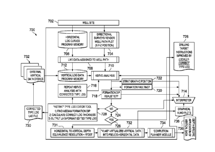
application of vertical data 434. Depth-specific application of vertical data
434 may
advantageously provide for improved visualization of subsurface stratigraphy
and may allow
for improved qualitative and quantitative analysis. In some embodiments, depth-
specific
application of vertical data 43 may be provided graphically and may allow for
improved
completion and design of frac procedures.
[0086] In some
embodiments, KBTVD data processing unit 414 may provide
quantitative and/or qualitative analysis 426 regarding stratigraphic position,
formation dips,
and geologic faults. Such analysis 426 may be performed by the KBTVD data
processing
unit 414, another appropriate processor, a practitioner, and/or a combination
thereof. Analysis
426 may result in new and/or changes to drilling target instructions 428. For
example, based
on analysis 426, drilling target instructions regarding the direction and/or
angle of the
wellbore at the well site 402 may be adjusted.
[0087] In some
embodiments, system 400 may provide for graphical virtual LWD
("VLWD") plots 430. Graphical VLWD may allow for additional interpretation or
data
analysis by an interpreter or processor 432. Interpreter or processor 432 may
extract
information from graphical VLWD plots 430 and provide further adjustments
and/or input to
KBTVD data processing unit 414.
[0088] The pseudo-
horizontal data may be presented via a screen or display.
FIGURE 5 shows an example screen presentation of pseudo-horizontal data or
virtual LWD
data. As shown in Figure 5, pseudo-horizontal data may be superimposed or
overlaid on top
of or next to actual horizontal LWD data. Other data may be displayed to
provide a user or
CA 02940191 2016-08-25
WO 2015/130836
PCT/US2015/017591
practitioner information regarding the stratigraphic characteristics of the
trajectory of a
wellbore. It should be appreciated that the screen presentation as shown in
Figure 5 is given
by way of example only. Various adjustments or additions may be made to the
screen
presentation without departing from the scope of the present disclosure.
[0089] In another
aspect of the present disclosure, embodiments may advantageously
correct a determination of bed thickness or interval thickness. Extrapolations
of KBTVD
data may generate exaggerated formation dips. Explained differently,
extrapolated KBTVD
data may suggest formation dips that are too steep ¨ either upwards or
downwards. Such
exaggerated formation dips may lead to erroneous drilling instructions and out-
of-zone
wellpaths. Similarly, the generation of Virtual LWD or pseudo-horizontal data
may lead to
slightly erroneous results. Errors may occur because the stratigraphy and rock
properties are
different between the type log and those found in the newer horizontal well.
[0090] Corrections
of such errors may be made to KBTVD data or pseudo-horizontal
data. Such corrections may allow for a determination of a true stratigraphic
thickness and
may no require the need for drilling vertical type wells or vertical pilot
wells solely for the
purpose of determining correct interval thickness. Indeed, such vertical pilot
wells may be
cost prohibitive and may significantly hamper the time and cost effectiveness
of a drilling
operation.
[0091] In some
embodiments, thickness corrections may advantageously be
performed prior to further processing of data. Thus, in some embodiments,
thickness
correction may be performed prior to extrapolating vertical data out into the
horizontal
direction to generate pseudo-horizontal data as previously described.
[0092] As
previously described, conversion or extrapolation of horizontal or near
horizontal MWD or LWD data to pseudo-vertical data may be performed using
various
algorithms. In some embodiments, appropriate algorithms may be based on
trigonometric
functions. For example, if drilling in an up-dip direction, wherein a
formation interval is
tilted upwards away from the drilling rig, pseudo-vertical data or KBTVD may
be expressed
as:
KBTVD = TVD + (tan(D))(VSD)
Or, if drilling in a down-dip direction, wherein a formation interval is
tilted downwards away
from the drilling rig, pseudo-vertical data or KBTVD may be expressed as:
CA 02940191 2016-08-25
WO 2015/130836
PCT/U82015/017591
21
KBTVD = TVD ¨ (tan(D))(VSD)
[0093] In such
expressions, KBTVD may be the Kelling Bushing True Vertical
Depth. TVD may be the True Vertical Depth. D may be the absolute value of a
formation
dip angle above or below a horizontal plane. VSD may be the Vertical Section
Distance.
[0094] By finding
the correct D angle solution, apparent Measured Depth Thickness
may be reconciled or compressed to a True Thickness. Then, the MWD-LWD log
curves
may be displayed according to their KBTVD. This may have the effect of
compressing
stretched-out or exaggerated MWD-LWD data into pseudo-vertical log curves that
may be
matched to corresponding type logs. In some embodiments, a processing unit may
extrapolate KBTVD data and give on-screen comparisons of one or more type logs
alongside
the extrapolated KBTVD data. A user or interpreter may input various D
solutions and may
select one that resolves the data such that the KBTVD data closely matches a
corresponding
vertical type log.
[0095] However, if
the thickness represented by a vertical type log is actually untrue,
certain repeatable and observable patterns may emerge in the geosteering
interpretation. For
example, FIGURE 6A depicts diagram 600A of wellpath 602A through a
stratigraphic
interval 604A. Diagram 600A depicts extrapolated type log 612A and actual log
606A. As
shown in Figure 6A, if the type log thickness 608A is thinner than the actual
thickness 610A,
a formation dip may appear to turn sub-parallel to a wellpath 602A.
[0096] As another
example, FIGURE 6B depicts another diagram 600B of wellpath
602B through a stratigraphic interval 604B. Diagram 600B depicts extrapolated
type log
612B and actual log 606B. In contrast to Figure 6A, if a type log thickness
608B is greater
than an actual value 610B, a formation dip may appear to turn opposite to the
wellpath 602B.
By recognizing either of these patterns, an interpreter may qualitatively know
that an interval
thickness in the type log is incorrectly too thick or too thin for the
vicinity of the horizontal
well being drilled. Embodiments of the present disclosure advantageously
provide further
quantitative information regarding the inaccurate thickness and advantageously
provide
methods of correcting said inaccurate thickness.
[0097] In some
embodiments of the present disclosure, a thickness error may be
quantified for the local area of a horizontal well and may then be precisely
corrected by
flattening any two limbs of an apparent formation dip sinusoid to a median
formation dip
value (D'). Then, as D is no longer a variable, a Corrected True Thickness
("CTT") may be
solved for. More reliable CTT algorithms may be formulated by finding median
D' value
CA 02940191 2016-08-25
WO 2015/130836
PCT/US2015/017591
22
across more than just two limbs of the sinusoid. In some embodiments, use of
two limbs may
advantageously promote a desired degree of accuracy or precision.
[0098] An example expression of a CTT may be:
CII = (Sin D') R
[0099] In the
example expression, CTT may be a Corrected True Thickness. D' may
be a median formation dip angle determined by finding median dip of two
sequential limbs of
an apparent dip
sinusoid. R may be a Measured Depth Interval Thickness as obtained
from MWD or LWD log curve data in a horizontal well.
[00100] In some
embodiments, a CTT value may be calculated or otherwise
extrapolated by a data processing unit. A CTT value may then be applied to a
digital type log
file. A digital type log file may be any appropriate file format such as LAS
or ASC formats.
An applied CTT value may effectively edit specific depth values in an ASC-type
file. For
images or visual renderings of type logs, a processing unit may compress or
stretch a vertical
axis of the log image across a zone or section in question.
[00101] A data
processing unit may further provide a visualization of a determined
CFI and a compressed or stretched log image. Additional confirmation of an
extrapolated
CTT may be performed by repeating the aforementioned data processing or data
analysis
across at least several hundred feet of horizontal data. This double-check,
however, may be
unnecessary if the first V-STRAT result is based upon sufficient data, such as
a few hundred
feet of the horizontal well.
[00102]
Determination of CTT may provide various advantages and be useful for
various applications. For example, determination of CTT may provide for more
accurate
thickness data which in turn may promote more precise maneuvering of a
wellbore through a
horizontal well. Horizontal wells may generate an enoimous spatial density of
subsurface
data. Such data may be in the form of log curves. Readings for log curves may
be taken
about every 0.5' to 1.0'. This may result in profoundly dense data sets that
may otherwise be
unobtainable. These close-spaced data points may also be fixed in three-
dimensional space
by the directional surveys and may therefore be spatially more precise than
any broad-scale
interpolation or extrapolation between vertical wells. By virtue of their
spatially dense data,
horizontal wells may reveal formation structural (dip changes and faulting)
and stratigraphic
details (variable bed thickness) that may not be revealed by other methods of
analysis. Thus,
operating companies may need the ability to mathematically and precisely
interpret and
CA 02940191 2016-08-25
WO 2015/130836
PCT/US2015/017591
23
integrate this new dense data set into maps, geologic reservoir evaluations,
reservoir volume
calculations, producible reserve calculations, and future well plans.
Accordingly, the present
disclosure may advantageously remove at least part of the guess work out of
the overall
subsurface data set by providing thickness-corrected vertical log data.
[00103] As another
example, for the purposes of KBTVD-based geosteering
techniques, a corrected-thickness type log may become available for the well
being drilled, as
well as future nearby wells. Consequently, phantom formation dip values that
were actually
artifacts of incorrect type log bed thicknesses may be eliminated or at least
substantially
diminished. One of ordinary skill in the art would appreciate that a primary
goal of most
geosteering interpretations may be to give drilling crews a reiteratively
corrected and
improved drilling target angle. This would allow drilling crews to better keep
the horizontal
wellpath in a productive target zone. Traditional methods may generally have
relied on
qualitative guesses to reconcile phantom formation dips and to estimate the
correct angle.
Present embodiments may quantitative address such issues and eliminate or
substantially
diminish phantom formation dips.
[00104] Yet another
example benefit arises in that Virtual LWD or pseudo-horizontal
data may be more accurately extrapolated if thickness errors have been
resolved from CTT
calculations. Such benefit may flow through to better designs of frac
treatments and
completions in general, post-completion reservoir and economic analyses, and
future well
planning. One of ordinary skill in the art having the benefit of the present
disclosure would
appreciate further advantages from the aforementioned determinations of CTT.
[00105] As
previously described, the methods and systems of providing for thickness
correction may advantageously be performed prior to extrapolation of vertical
data into
pseudo-horizontal data. Accordingly, in some systems, a first data processing
step may
comprise extrapolating pseudo-vertical data and resolving incident angles. A
second data
processing step may comprise resolving thickness inaccuracies and determining
a CTT. A
third data processing step may comprise using an established horizontal-foot-
to-vertical-foot
equivalence to extrapolate pseudo-horizontal data or Virtual LWD data.
[00106] In some
embodiments, analysis and processing of data through the
aforementioned steps may be iterative. For example, new data may be added as
drilling of a
horizontal well progresses. New data collected may advantageously provide for
a better
stratigraphic understanding in both the horizontal and vertical directions. As
another
example, bed thicknesses may change in real geological environments.
Accordingly, iterative
CA 02940191 2016-08-25
WO 2015/130836
PCT/US2015/017591
24
analysis and correction of any interval thickness errors may advantageously
provide for better
geo steering.
[00107] Iterative
aspects of the present disclosure may also be seen in Figure 3, Figure
4, and Figure 7. For example, as seen in FIGURE 7, a KBTVD analysis may
generate
apparent (calculated) formation dips. The generated apparent formation dip may
be assessed
as whether geologically valid or not. Such assessment may be performed by, for
example, a
user Or a processor. If repetitive sinusoidal dip changes are observed, it may
be concluded
that an apparent formation dip is invalid or inaccurate. If an apparent
calculated formation
dip is geologically implausible in a local area, it may be concluded that an
apparent formation
dip is invalid or inaccurate. If an apparent formation dip is determined as
being invalid or
inaccurate, thickness correction processes may be run. Once a CTT is
deteimined, an edited
type log file may be sent to a vertical log data table.
[00108] In some
embodiments, the present disclosure provides for systems operable
for calculating CTT. Figure 7 depicts an example system according to the
present disclosure.
It should be appreciated that the example system depicted in Figure 7 may
comprise any and
all of the features previously described in Figure 3 and Figure 4.
[00109] The system
may comprise various memory units and processing units as
depicted in Figure 7. A memory unit may be a non-transitory computer-readable
storage
medium. Such storage medium may be a random access memory (RAM), a read only
memory (ROM), a memory card, a magnetic and/or optical recording medium and
its
corresponding drive, or any other appropriate storage device. A processing
unit may be any
of a processor, a microprocessor, a processing logic that may interpret and
execute
instructions, or other appropriate device. Additional memory units and
processing units may
be used without departing from the scope of the present disclosure.
[00110] The system
of Figure 7 may comprise a processing unit for determining
Corrected True Thickness. Said processing unit may receive a determination of
whether a
formation dip is or is not realistic or accurate. In some embodiments, a
processing unit may
only receive a determination that a formation dip is not accurate. Said
processing unit may
find a median of a formation dip, calculate correct log thickness, and output
an LAS-format
edited type log. One of ordinary skill in the art would appreciate that other
types or formats
of output files may be appropriate and may not depart form the scope of the
present
disclosure.
[00111] An output
type log or a coffected type log file may be transmitted to another
processor for KBTVD analysis. In some embodiments, an analysis for CTT and
KBTVD
CA 02940191 2016-08-25
WO 2015/130836
PCT/US2015/017591
may occur on the same processor. In some embodiments, a corrected type log may
be
transmitted to an external vertical data store, and then be transmitted again
to a vertical log
data program memory.
[00112] More
specifically, as shown in Figure 7, a system 700 of the present disclosure
may comprise a well site 702. Well site 702 may collect data or otherwise
provide data from
user inputs or memory storage devices. For example, in some embodiments, well
site 702
may provide for rendering of wellpath plots via directional surveys 704. As
another example,
data collected at well site 702 may be stored in a program memory. For
example, system 700
may provide for horizontal log curves program memory 706. Horizontal log
curves program
memory 706 may be in communication with well site 702. In this manner,
horizontal log
curves program memory 706 may receive from and/or transmit data to well site
702.
[00113] In some
embodiments, system 700 may assign LWD data to a wellpath 708.
Such assignment and related calculations and/or computation may be perfoimed
by a
processing unit such as a processor, a microprocessor, a processing logic that
may interpret
and execute instructions, or other appropriate device. In some embodiments,
after LWD data
has been assigned to a wellpath, KBTVD Analysis 710 may be performed.
[00114] KBTVD
Analysis 710 may utilize data input from a variety of sources. For
example, a processor performing KBTVD Analysis 710 may receive data from
vertical log
data program memory 712, data from an interpreter 714 or practitioner, and/or
repeated
KBTVD analysis with corrected type log 716.
[00115] KBTVD
Analysis 710 may advantageously provide valuable qualitative and/or
quantitative assessment of a frac project. KBTVD Analysis 710 may help assess
whether a
formation dip is realistic or accurate 718, whether there is formation
faulting 720, and the
stratigraphic position 722 of particular layers. Based on any of these
qualitative and/or
quantitative assessments, interpreter 714 may adjust the parameters of the
system 700. For
example, the interpreter 714 may input new assumptions for processing or the
interpreter 714
may reposition or change the course of the vvellbore at the well site 702.
[00116] As a
specific example, KBTVD Analysis 710 may help asses whether a
formation dip is realistic or accurate 718. Methods of performing such assess
can be seen in
Figure 6A and Figure 6B and the accompanying description. If the formation dip
is not
realistic 724, particular processes may be implemented to help correct the
formation dip
value. In the example shown in Figure 7, such processes is referred to as a "V-
Strat" Type
Log Editor Tool 728. The "V-Strat" Type Log Editor Tool may find a median of
the
formation dip, may calculate a corrected log thickness, and may output LAS-
format edited
CA 02940191 2016-08-25
WO 2015/130836
PCT/US2015/017591
26
type log. An outputted corrected type log LAS file 730 may be transmitted to
and/or stored
on a non-transient memory device such as external vertical data stores 732.
Further, corrected
type log LAS file 730 may be provided, either directly or through external
vertical data stores
732 and/or vertical log data program memory to a process performing the KIITVD
analysis
710.
[00117] As
discussed, KBTVD Analysis 710 may help asses whether a formation dip
is realistic or accurate 718. If the formation dip is realistic 726, drilling
target instructions
may be improved by locally correct type logs. 728. Further, if the formation
dip is realistic
726, system 700 may thus provide data for horizontal to vertical depth
equivalence 730. In
some embodiments, resolution for said horizontal to vertical depth equivalence
730 may be at
about less than or equal to one foot.
[00118] Horizontal
to vertical depth equivalence 730 as provided by system 700 may
be further processed for VLWD 732. VLWD 732 may virtualize vertical data into
pseudo-
horizontal data or computed horizontal logs. VLWD 732 may be further
transmitted to a
Completion Planner Module 734. Completion Planner Module 734 may be operable
to
facilitate the designing of frac jobs. Completion Planner Module 734 may have
any of the
capabilities and features described for Completion Planner Module 424 as
depicted in Figure
4. For example, Completion Planner Module 734 may also provide for depth-
specific
application of vertical data 736. Depth-specific application of vertical data
736 may
advantageously provide for improved visualization of subsurface stratigraphy
and may allow
for improved qualitative and quantitative analysis.
[00119] Further,
VLWD 732 may provide for graphical VLWD plots 738. Graphical
VLWD plots 738 may be presented on any appropriate digital display device.
Graphical
VLWD plots 738 may be presented or provided to interpreter 714 for further
qualitative
and/or quantitative analysis.
[00120] As will be
understood by those skilled in the art who have the benefit of the
instant disclosure, other equivalent or alternative devices, methods, and
systems for
geosteering may be envisioned without departing from the scope of the
description contained
herein. Accordingly, the manner of carrying out the disclosure as shown and
described is to
be construed as illustrative only.
[00121] Persons
skilled in the art may make various changes in the shape, size,
number, and/or arrangement of parts without departing from the scope of the
present
disclosure. For example, the position and number of memory units or processing
units may
be varied. In some embodiments, memory units or processing units may be
interchangeable.
CA 02940191 2016-08-25
WO 2015/130836
PCT/US2015/017591
27
In addition, the size of a device and/or system may be scaled up or down to
suit the needs
and/or desires of a practitioner. For example, a user interface device or a
screen/display for
presenting screen presentations of various geosteering data may vary in size
as desired by a
practitioner. Each disclosed method and method step may be performed in
association with
any other disclosed method or method step and in any order according to some
embodiments.
Where the verb "may" appears, it is intended to convey an optional and/or
permissive
condition, but its use is not intended to suggest any lack of operability
unless otherwise
indicated. Persons skilled in the art may make various changes in methods of
preparing and
using a composition, device, and/or system of the disclosure.
[00122] Also, where
ranges have been provided, the disclosed endpoints may be
treated as exact and/or approximations as desired or demanded by the
particular embodiment.
Where the endpoints are approximate, the degree of flexibility may vary in
proportion to the
order of magnitude of the range. For example, on one hand, a range endpoint of
about 50 in
the context of a range of about 5 to about 50 may include 50.5, but not 52.5
or 55 and, on the
other hand, a range endpoint of about 50 in the context of a range of about
0.5 to about 50
may include 55, but not 60 or 75. In addition, it may be desirable, in some
embodiments, to
mix and match range endpoints. Also, in some embodiments, each figure
disclosed (e.g., in
one or more of the examples, tables, and/or drawings) may form the basis of a
range (e.g.,
depicted value +/- about 10%, depicted value +/- about 50%, depicted value +/-
about 100%)
and/or a range endpoint. With respect to the former, a value of 50 depicted in
an example,
table, and/or drawing may form the basis of a range of, for example, about 45
to about 55,
about 25 to about 100, and/or about 0 to about 100.
[00123] All or a
portion of a device and/or system for geosteering may be configured
and arranged to be disposable, serviceable, interchangeable, and/or
replaceable. These
equivalents and alternatives along with obvious changes and modifications are
intended to be
included within the scope of the present disclosure. Accordingly, the
foregoing disclosure is
intended to be illustrative, but not limiting, of the scope of the disclosure
as illustrated by the
appended claims.
[00124] The title,
abstract, background, and headings are provided in compliance with
regulations and/or for the convenience of the reader. They include no
admissions as to the
scope and content of prior art and no limitations applicable to all disclosed
embodiments.