Note: Descriptions are shown in the official language in which they were submitted.
CA 02940792 2016-08-31
SYSTEMS AND METHODS FOR
AUTOMATED MAPPING AND ACCURACY-TESTING
BACKGROUND
Technical Field
[0001] The present disclosure relates to systems and methods for automated
mapping and
accuracy-testing for electromagnetic navigation systems. More particularly,
the present
disclosure relates to systems and methods that automatically measure strength
of the
electromagnetic fields for electromagnetic navigation to obtain mapping data
and test accuracy
of the mapping data.
Discussion of Related Art
[0002] Electromagnetic navigation (EMN) systems have helped to expand
potentials of
treatment to internal organs and diagnosis of diseases. The EMN systems rely
on non-invasive
imaging technologies, such as computed tomography (CT) scanning, magnetic
resonance
imaging (MRI), or fluoroscopic technologies. These images may be registered to
a patient
within electromagnetic fields, and as a result the location of a sensor placed
inside of the patient
within the electromagnetic fields can be identified in the images. As a
result, the EMN in
combination with these non-invasive imaging technologies is used to identify a
location of a
target and to help clinicians navigate inside of the patient's body to the
target.
[0003] In order to visualize internal organs and diagnose diseases,
accurate mapping data
needs to be stored in the EMN system. Generally, the EMN systems measure
strength of EM
fields, compare the measured strength with the mapping data, and generate
visual images. The
more accurate the mapping data, the more accurate images can be obtained and
the more
accurate locations of targets or internal organs can be identified. The
mapping data has been
obtained manually. For example, manufacturers or users manually measure
strength of EM field
1
CA 02940792 2016-08-31
at each of the predetermined position and store the measured strength as the
mapping data into
EMN systems before initially using the EMN systems. Accuracy of the mapping
data can be
enhanced by automation of generating the mapping data.
[0004] Physical structures of an EMN system may be changed while
installing the EMN
system at an operating room different from the place of generating the mapping
data and/or after
the EMN system has been used for a period. Further, EM fields generated by the
EMN system
may be influenced by an external ferrous material near the system and
generated images can
neither accurately depict internal organs or targets nor can be used to
diagnose diseases. Thus,
automatic accuracy tests of the mapping data can also improve assurance of
accuracy of the
mapping data.
SUMMARY
[0005] Generally, the present disclosure provides systems and methods for
automatically
generating mapping data for EMN systems and testing accuracy of the mapping
data. In an
embodiment, the apparatus includes a sensor sensing EM vectors of an EM field
generated by the
EMN system, a carriage moving the sensor along a first direction and a second
direction different
from the first direction, wherein the sensor is fixedly attached to the
carriage, a first position
detector operatively associated with the sensor and detecting a first position
of the sensor along
the first direction, where the first position is one of predetermined
positions along the first
direction, a second position detector operatively associated with the sensor
and detecting a
second position of the sensor along the second direction, wherein the second
position is one of
predetermined positions along the second direction, and a controller
operatively associated with
the sensor and controlling movements of the carriage along the first and
second directions and
mapping the EM field based on the sensed EM vectors at predetermined positions
in a coordinate
2
CA 02940792 2016-08-31
system defined by the first direction, the second direction, and a third
direction perpendicular to
a plane defined by the first and second directions.
[0001] In an aspect, the apparatus further includes a plurality of signal
generators each of
which being configured to generate a signal and each of which being positioned
at a
corresponding position of the predetermined positions along the first
direction. The sensor is
configured to sense an EM vector when the first position detector detects a
signal strength
generated by each of the plurality of signal generators along the first
direction. The plurality of
signal generators are light emitting diodes (LEDs) where the first position
detector detects a
strength of light emitted by the LEDs. The plurality of signal generators
along the second
direction is activated for mapping and accuracy-testing.
[0006] In another aspect, the predetermined positions along the second
direction include
a first group and a second group, where the sensor is configured to sense an
EM vector for
mapping at the first group of the predetermined positions along the second
direction. The sensor
is configured to sense an EM vector for accuracy-testing at the second group
of the
predetermined positions along the second direction. The apparatus further
includes a first
plurality of signal generators each being configured to generate a signal, and
each of which is
positioned at a corresponding position of the first group and a second
plurality of signal
generators each being configured to generate a signal, and each of which is
positioned at a
corresponding position of the second group.
[0007] The sensor is configured to sense an EM vector when the second
position detector
detects a maximum strength of a signal generated by one of the first and
second pluralities of
signal generators along the second direction. The first and second pluralities
of signal generators
are light emitting diodes (LEDs), and wherein the second position detector
detects strength of
3
CA 02940792 2016-08-31
light emitted by the LEDs. The LEDs of the first plurality of signal
generators are configured to
generate light having a first color, and wherein LEDs of the second plurality
of signal generators
are configured to generate light having a second color different from the
first color.
[0008] In another aspect, each of the first and second position detectors
defines a slit
therein, and the first and second position detectors are configured to detect
strength of light
passing through the corresponding slit of the first and second position
detectors, respectively.
[0009] The first plurality of signal generators are activated and the
second plurality of
signal generators are deactivated when the apparatus is operated for
generating mapping data.
The first plurality of signal generators are deactivated and the second
plurality of signal
generators are activated when the apparatus is operated for generating
accuracy-testing data.
[0010] In yet another aspect, the sensor includes an EM sensor configured
to sense an
EM vector along the third direction, and wherein the EM sensor is configured
to be manually
moved along the third direction. The EM sensor is configured to sense 6
degrees of freedom.
[0011] In yet another aspect, the sensor includes a plurality of sensors,
each of which is
located at corresponding one of predetermined positions along the third
direction.
[0012] In still another aspect, the apparatus further includes a bottom
layer configured to
center the apparatus over an EM field generated by the EMN system.
[0013] In still another aspect, the apparatus is mostly made of non-
ferrous materials.
[0014] In yet another aspect, the apparatus further includes a first motor
coupled with the
sensor via a first shaft and configured to move the sensor along the first
direction, and a second
motor coupled with the sensor via a second shaft and configured to move the
sensor along the
second direction. The first and second motors are spaced a distance from the
EM field a
sufficient distance to minimize influence to the EM field and are non-ferrous.
The controller is
4
CA 02940792 2016-08-31
further configured to control the first and second motors.
[0015] In another embodiment, a method for mapping and accuracy-testing an
EM field
generated by an EMN system includes moving a sensor to an initial position on
a plane defined
by a first direction and a second direction different from the first
direction, sensing an EM vector
at each of predetermined positions in a coordinate system defined by the plane
and a third
direction perpendicular to the plane, sampling the sensed EM vector to obtain
digital samples,
and generating data for mapping or accuracy-testing based on the digital
samples.
[0016] The predetermined positions are defined by first predetermined
positions along
the first direction, second predetermined positions along the second
direction, and third
predetermined positions along the third direction. The second predetermined
position includes a
first group of positions for mapping and a second group of positions for
accuracy-testing,
wherein signal generators located at the first group are configured to
generate signals for
mapping, and further wherein signal generators located at the second group are
configured to
generate signals for accuracy-testing.
[0017] A signal generator is located at each of the third predetermined
positions and the
method further includes moving the sensor along the third direction and
sensing an EM vector
when strength of a signal generated by a signal generator is a maximum.
[0018] In an aspect, the sensor includes EM sensors, each of which is
located at a
corresponding position of the third predetermined positions.
[0019] In another aspect, the step of moving the sensor to the initial
position includes
activating a first signal generator located at a beginning position of the
first predetermined
positions and a second signal generator located at a beginning position of the
second
predetermined positions, and moving the sensor to a position where the sensed
strength is a
CA 02940792 2016-08-31
maximum along the first and second directions. The step of moving the sensor
further includes
deactivating all of signal generators except the first and second signal
generators.
[0020] In another aspect, the method further includes generating a fitted
curve of the
mapping data based on the digital samples and storing the fitted curve in the
EMN system.
Further , the method includes generating accuracy-testing data, calculating
deviation of the
accuracy-testing data from the fitted curve, determining whether the deviation
is greater than a
threshold, and generating a warning of re-generating the mapping data when it
is determined that
the deviation is not less than the threshold. The method further includes
disabling the EMN
system when it is determined that a deviation is not less than a threshold.
[0021] Any of the above aspects and embodiments of the present disclosure
may be
combined without departing from the scope of the present disclosure.
BRIEF DESCRIPTION OF THE DRAWINGS
[0022] Objects and features of the presently disclosed systems and methods
will become
apparent to those of ordinary skill in the art when descriptions of various
embodiments are read
with reference to the accompanying drawings, of which:
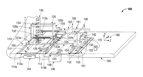
[0023] FIG. 1 is a perspective view of a system for generating mapping
data and testing
accuracy of the mapping data for an electromagnetic navigation (EMN) system in
accordance
with an illustrative embodiment of the present disclosure;
[0024] FIGS. 2A and 2B are perspective views of Z-axis and X-axis rails
with
corresponding printed circuit boards of the system of FIG. 1, respectively, in
accordance with an
illustrative embodiment of the present disclosure;
[0025] FIG. 3 is a graphical illustration of signal strength of mapping
data along Z-axis
in accordance with an illustrative embodiment of the present disclosure;
6
CA 02940792 2016-08-31
[0026] FIG. 4 is a graphical illustration of predetermined points in Y-Z
plane in
accordance with an illustrative embodiment of the present disclosure;
[0027] FIG. 5 is a graphical illustration of test points in X-Z plane in
accordance with an
illustrative embodiment of the present disclosure;
[0028] FIG. 6 is a functional block diagram of the system of FIG. 1 in
accordance with
an illustrative embodiment of the present disclosure;
[0029] FIGS. 7A and 7B are flowcharts of a method for generating mapping
data for an
EMN system in accordance with an illustrative embodiment of the present
disclosure; and
[0030] FIGS. 8A-8C are flowcharts of a method for testing accuracy of the
mapping data
in accordance with an illustrative embodiment of the present disclosure.
DETAILED DESCRIPTION
[0031] The present disclosure is related to systems and methods for
automatically
generating mapping data for EMN systems and testing accuracy of the mapping
data. Before
using an EMN system, the present disclosure provides systems and methods to
measure strength
of EM field at predetermined positions over an EM field generated by the EMN
system, generate
mapping data based on the measured strength, and store the mapping data into
the EMN system.
Further, the systems and methods of the present disclosure test the accuracy
of the mapping data
of the EMN system after a period of usage of the EMN system and re-generate
new mapping
data when deviation of the test from the mapping data is greater than a
predetermined threshold
value.
[0032] Although the present disclosure will be described in terms of
specific illustrative
embodiments, it will be readily apparent to those skilled in this art that
various modifications,
rearrangements, and substitutions may be made without departing from the
spirit of the present
7
disclosure.
[0033] FIG. 1 illustrates a system 100 for automatically generating
mapping data for an
electromagnetic navigation (EMN) system and testing accuracy of the mapping
data. For
example, an EMN system may be the ELECTROMAGNETIC NAVIGATION
BRONCHOSCOPY system currently sold by Covidien LP, a division of Medtronic
pie. The
EMN system utilizes electromagnetic field to non-invasively identify locations
of internal organs
and diseased portions inside of a patient's body. Strength of electromagnetic
field specific to a
predetermined position is used to identify a location of such and is saved in
the EMN system in a
form of mapping data, which the system 100 generates.
[0034] The system 100 includes a platform 110, a carriage 120, a field
sensing device
130, and a controller 140. The platform 110 is placed on a location board 190
of an EMN
system. In particular, the platform 110 stands over an EM field generator 195
of the EMN
system. The platform 110 includes a corner piece 112, which frames the
location board 190 so
that the system 100 may be centered over the EM field generated by the EM
field generator 195.
hi an aspect, the corner piece 112 may be two corner pieces which are
diagonally positioned so
that the two comer pieces fit two diagonal corners of the EM field generator
195.
[0035] The carriage 120 includes two rails 114a and 114b aligned in
parallel along the X-
axis as shown in an axis-indicator 180 placed on the platform 110 and
supporting the rest of the
carriage 120. The first rail 114a is just a rail while the second rail 114b
may be formed of a
composite of a printed circuit board (PCB) 210 and a riding surface 220, as
shown in FIG. 2A.
The PCB 210 includes a plurality of grid position signal source generators
212, which generate
signals for indicating predetermined positions for mapping data for EMN
systems.
8
CA 2940792 2018-05-02
CA 02940792 2016-08-31
[0036] In an aspect, the grid position signal source generators 212 may be
light emitting
diodes (LEDs), laser light generators, audio generators, and the like. In
another aspect, the grid
position signal source generators 212 are located on predetermined positions
on the PCB 210. In
instances where the grid position signal source generators 212 are LEDs, the
riding surface 220
may be sufficiently transparent to transmit the light generated by the grid
position signal source
generators 212 through the riding surface 220. The transparency of the riding
surface 220 does
not substantially disperse the light but directs the light to the top of the
riding surface 220. In
another aspect, the riding surface 220 may have slits 222 located over the
grid position signal
source generators 212 so that the light generated by the grid position signal
source generators
212 are substantially unobstructed to transmits through the riding surface
220. The riding
surface 220 may be affixed to the PCB 210 via a fixing means 230, which
includes a rivet,
adhesive, nail, staples, or the like.
[0037] The platform 110 may also include pieces that connect each element
of the
platform 110. For example, a center piece 111 may be used to hold the corner
piece 112 and two
bottom pieces 113a and 113b are used to connect the two rails 114a and 114b,
and the center
piece 111, as shown in FIG. 1. Further, the platform 110 is used as a base for
holding the
carriage 120.
[0038] The carriage 120 includes first and second shafts 122a and 122b,
which are
parallelly positioned to each other along Z-axis as shown in the axis-
indicator 180, and first and
second side bars 123a and 123b. Each of the first and second shafts 122a and
122b has two
wheels rolling over the two rails 114 and 114b, respectively. Two wheels may
be made of
rubber or similar materials. The first shaft 122a is mechanically coupled to
the controller 140 so
that the carriage 120 can move along the X-axis over the two rails 114 and
114b. The first and
9
CA 02940792 2016-08-31
second shafts 122a and 122b are locked by the first and second side bars 123a
and 123b.
[0039] A signal detector 124 may be attached to the second side bar 123b
and positioned
over the second rail 114b. When the first and second shafts 122a and 122b are
moved along the
X-axis, the signal detector 124 senses strength of the signals generated by
the grid position signal
source generators 212 of FIG. 2A. In an aspect, the signal detector 124 may
comprise a slit
formed on its underside to sense strength of the signal from a grid position
signal source
generators 212 which the signal detector passing over. Sensed result is
transmitted to the
controller 140.
[0040] The carriage 120 further includes a third rail 126 extending along
the Z-axis
direction as shown in the axis-indicator 180. The third rail 126 is formed of
a composite
including a printed circuit board (PCB) 240 and a riding surface 250, as shown
in FIG. 2B. The
PCB 240 includes a plurality of grid position signal source generators, which
are separated into
two groups, i.e., a first kind 242 and a second kind 244. The grid position
signal source
generators of the first kind 242 generate signals for generating mapping data
and the grid
position signal source generators of the second kind 244 generate signals for
testing accuracy of
the mapping data.
[0041] In an aspect, the grid position signal source generators 242 and
244 may be LEDs,
laser light generators, audio generators, and the like. In another aspect, the
grid position signal
source generators 242 and 244 are located at predetermined positions on the
PCB 240. In further
aspect, each grid position signal source generator of the second kind 244 is
positioned between
two consecutive grid position signal source generators of the first kind 242.
In still further aspect,
the number of grid position signal source generators of the first kind 242 is
greater than that of
the second kind 244. In yet another aspect, grid position signal source
generators of the first
CA 02940792 2016-08-31
kind 242 may be positioned and equally distanced from each other.
Nevertheless, the positions
of the grid position signal source generators 242 and 244 are not limited to
these aspects but can
be modified by one having ordinary skill in the art without departing from the
scope of the
present disclosure.
[0042] In case that the grid position signal source generators 242 and 244
are LEDs, the
riding surface 250 may be sufficiently transparent to transmit the light
generated by the grid
position signal source generators 242 and 244 to the top of the riding surface
250. The
transparency of the riding surface 250 does not disperse the light
substantially but directs the
light through the top surface of the riding surface 250. In an aspect, the
riding surface 250 may
have slits 252 located over the grid position signal source generators 242 and
244 so that the
light generated by the grid position signal source generators 242 and 244 can
be unobstructed
and transmitted through the riding surface 250.
[0043] The grid position signal source generators of the first kind 242
may generate a
first color and the grid position signal source generator of the second kind
244 may generate a
second color different from the first color. For example, the first color may
be green and the
second color may be red. In an aspect, a same color may be generated by the
grid position signal
source generators 242 and 244. The bottom surface of the riding surface 250
may be affixed
with the PCB 240 via a fixing means 260, which includes a rivet, adhesive,
nail, staples, or the
like.
[0044] The carriage 120 also includes first and second vertical bars 128a
and 128b,
which are affixed over the first and second sidebars 123a and 123b,
respectively. The first and
second vertical bars 128a and 128b are distanced and connected by sidebars and
the third rail 126.
[0045] The carriage 120 also includes a third shaft 129, which connects
the field sensing
11
CA 02940792 2016-08-31
device 130 to the controller 140 through the second vertical bar 128b. The
third shaft 129 may
have circular gear teeth thereon or another means that mechanically and
operationally couples to
an opening in the second vertical bar 128b, so that rotation of the third
shaft 129 around Z-axis
can be converted into a linear directional movement of the field sensing
device 130 along the Z-
axis but does not affect movement of the carriage 120. Structure of the
opening of the second
vertical bar 128b may be readily implemented by a person having ordinary skill
in the art.
[0046] The field sensing device 130 includes a signal detector 132 and a
plurality of
sensors 134. The signal detector 132 is positioned over the third rail 126 and
senses strength of
the signals generated by the grid position signal source generators of the
first kind 242 and the
second kind 244. In an aspect, the signal detector 132 may also include a slit
252 formed on its
underside to detect strength of the signal passing through the slit 252.
[0047] The plurality of sensors 134 are located at predetermined positions
along the Y-
axis and configured to detect EM vectors of the EM field generated by the EM
field generator
195 of the EMN system. In an aspect, the plurality of sensors 134 may be 6
degrees of freedom
(DOE) sensors, which can sense three directions (e.g., X,-, Y-, and Z-
directions) and three
rotations (e.g., pitch, yaw, and roll) based on sensed EM vectors of the EM
fields. The 6 DOF
sensors is provided as an example and not intended to limit other kinds of
sensors for the
plurality of sensors 134.
[0048] The controller 140 includes a vertical board 142, a first motor
portion 150, a
second motor portion 160, and a control circuitry 170. The first motor portion
150 is attached to
the vertical board 142. The first motor portion 150 is connected to the first
shaft 122a of the
carriage 120 and configured to control directional movements of the carriage
120 along the X-
axis. The second motor portion 160 is connected to the third shaft 129 of the
carriage 120 and
12
CA 02940792 2016-08-31
configured to control directional movements of the field sensing device 130
along the Z-axis.
Since the control circuitry 170 is connected with an interconnect PCB 172
configured to relay
information (position or orientation data) between the control circuitry 170
and the signal
detectors 124 and 132, the control circuitry 170 controls the movements of the
carriage 120 and
the field sensing device 130 along the X-axis and Z-axis, respectively and
independently, based
on the position or orientation data.
[0049] The first motor portion 150 includes a bottom 151, two rails 152,
two shafts 153,
a belt 154, and a first motor 155. The bottom 151 forms the base of the
controller 140 and two
rails 152 are affixed in parallel to the top surface of the bottom 151 along
the X-axis. Each of
two shafts 153 includes two wheels configured to roll over the two rails 152,
and is connected
through the vertical board 142. When powered and controlled, the first motor
155 generates
rotational movements, which is transmitted to the first shaft 122a. Then, the
circular movements
of the first shaft 122a cause the four wheels of the carriage 120 to roll over
the two rails 114a and
114b.
[0050] One of the two shafts 153 is connected to the first motor 155 or
the first shaft
122a via the belt 154 so that the four wheels of the first motor portion 150
also roll over the two
rails 152 synchronously with the four wheels of the carriage 120. In this way,
the controller 140
simultaneously follows movements of the carriage 120, correspondingly.
[0051] The second motor portion 160 includes one or more shafts 161 and a
second
motor 162. The shafts 161 connect the second motor 162 through openings of the
vertical board
142 of the controller 140. When powered and controlled, the second motor 162
generates
rotational movements around the Z-axis, which is transmitted to the third
shaft 129. The
rotational movements of the third shaft 129 around the Z-axis are converted to
the directional
13
CA 02940792 2016-08-31
movements along the Z-axis so that the field sensing device 130 moves along
the Z-axis. The
second motor 162 and the shafts 161 also move along the Z-axis corresponding
to the
movements of the field sensing device 130. The shafts 161 are configured to
smoothly slide
through an opening of the vertical board 142.
[0052] The first motor 155 and the second motor 162 are independently
controlled by the
control circuitry 170.
[0053] The controller 140 further includes a converter 144, a continuous
guidance system
(CGS) 146, and a computing device 148. The converter 144 is configured to
receive sensed EM
vectors from the field sensing device 130, which are analog signals, and to
convert the analog
result into digital samples. In one example, the sampling frequency of the
converter 144 is an
integer multiple of the frequency of the EM field generated by the EM field
generator 195. The
digital samples also include time stamp information indicating what time the
plurality of sensors
134 senses the EM vectors.
[0054] The digital samples are transmitted to the CGS 146, which collects
the magnetic
field measurement data and computes the sensor locations and orientations for
each coil within
the EM sensor assembly. The magnetic field map that is generated from this
data collection
corrects for field distortions from ferrous objects in the environment. This
map is used to
accurately locate the EM sensors during the EMN procedures.
[0055] The CGS 146 sends digital samples, (i.e., sensor position and
orientation samples)
with the corresponding time stamp information to the computing device 148,
which extracts
mapping data from the digital samples. The control circuitry 170 sends
positional information of
the plurality of sensors 134 to the computing device 148. The computing device
148 associates
the digital samples with the positional information and saves the results as
mapping data.
14
CA 02940792 2016-08-31
[0056] In an aspect, the computing device 148 further performs curve
fitting process to
calculate and find out fitted curves of the mapping data. FIG. 3 illustrates a
fitted curve 310
based on mapping data of a position y at the Y-axis and a position x at the X-
axis along the Z-
axis. 18 predetermined positions for mapping data are illustrated as integer
coordinates, such as
1-18, and 5 predetermined positions for accuracy testing data are illustrated
in between
coordinates 1 and 2, 5 and 6, 9 and 10, 13 and 14, and 17 and 18. The numbers
of the
predetermined positions for mapping data and for accuracy testing data are
provided as examples
and not intended limiting.
100571 The computing device 148 utilizes curve fitting techniques to find
a curve fitting
to the 18 mapping data. The fitted curve 310 may be polynomial function based
or harmonic
function based. In an aspect, the first or last predetermined position may not
be used for
mapping data or accuracy testing data and may be used to indicate starting and
ending positions
to get data.
[0058] When generating the mapping data, the signal detector 124 of the
carriage 120
senses strength of the signal generated by the grid position signal source
generators of the first
kind 242 through a slit. Curve 320 illustrates a distribution of the strength
detected by the signal
detector 124. When the strength reaches the maximum 325, the plurality of
sensors 134 of the
field sensing device 130 senses EM vectors of the EM field and transmits the
sensed results to
the converter 144 together with the time stamp information. After collecting
mapping data for
all predetermined positions for mapping data are obtained, the computing
device 148 generates
fitted curves.
[0059] Accuracy of the mapping data may be checked after the mapping data
has been
generated. In case of checking accuracy, the signal detector 124 of the
carriage 120 senses
CA 02940792 2016-08-31
strength of the signal generated by the grid position signal source generators
of the second kind
244 through the slit 252. When the strength of the signal generated by the
grid position signal
source generators of the second kind 244 reaches the maximum 325, the
plurality of sensors 134
of the field sensing device 130 senses EM vectors of the EM field and
transmits the sensed
results to the converter 144. The field sensing device 130 sends time stamp
information with the
sensed results. The time stamp information indicates when the EM vectors are
sensed.
[0060] After the accuracy testing data is generated, a deviation error of
the accuracy
testing data from the fitted curve 310 is calculated. The fitted curve 310
provides expected
strength at a predetermined position for accuracy testing, which is compared
with the accuracy
testing data obtained at the predetermined position. The computing device 148
determines
whether the deviation error is within a tolerance range. In case when it is
determined that the
deviation error is not within the tolerance range, the operator or user of the
system 100 is notified
that the mapping data needs to be re-generated via displaying a warning
message on a display
screen or generating an warning audio.
[0061] As shown in FIGS. 2A-4, the grid position signal source generators
of the second
kind 244 are located on the Z-axis but not on the X-axis and not on the Y-
axis. Thus, when the
field sensing device 130 scans through the Z-axis, the field sensing device
130 senses the EM
vectors at the predetermined positions based on the mode (i.e., generating
mapping data or
generating accuracy testing data) of the system 100. In other words, when the
mode is set to
generate mapping data, all data sensed by the field sensing device 130 is used
to generate the
mapping data when the signal detector 124 detects the maximum signal strength
over a grid
position signal source generator of the first kind 242 and all data sensed by
the field sensing
device 130 is not used for generating mapping data when the signal detector
124 detects the
16
CA 02940792 2016-08-31
maximum signal strength at a grid position signal source generator of the
second kind 244.
[0062] FIG. 5 illustrates predetermined positions in the X-Z plane. The
field sensing
device 130 senses the EM vectors from the first position to the last position
along the X-axis
likewise the field sensing device 130 senses the EM vectors from the first
position to the last
position along the Z-axis. In an aspect, the first and last position along the
X-axis or the Z-axis
may be used to initialize the position of the mapping data or the accuracy
testing data. In other
words, the first and last position may not be used for the mapping data or the
accuracy testing
data but used for the field sensing device 130 to start or end sensing EM
vectors. As such,
grayed area surround by the first and last positions may be used as the
predetermined positions
for generating mapping data and accuracy-testing data.
[0063] With regard to the initialization of the position, when a grid
position signal source
generator at the first or last position is powered on, the other grid position
signal source
generators may be powered down and the signal detector moves until the
initialization light is
found. As such, the position for initialization may be identified. In an
aspect, after the position
for initialization is found, the other grid position signal source generators
are powered on and the
field sensing device 130 starts sensing the EM vectors at predetermined
positions where the grid
position signal source generators emit light.
[0064] FIG. 6 illustrates a functional block diagram of the system 100 of
FIG. 1. The
system 100 includes the control circuitry 170, which includes a processor 610
and low-pass
filters (LPFs) 615a-615d. The control circuitry 170 controls the first motor
155 and the second
motor 162. The control circuitry 170 is connected with an interconnect PCB 172
configured to
relay information between the control circuitry 170 and the signal detectors
124 and 132.
[0065] When the control circuitry 170 is powered up from the power source
630, the
17
CA 02940792 2016-08-31
processor 610 controls the first motor 155 and the second motor 162 so that
the carriage 120 and
the field sensing device 130 move to their initial position. The control
circuitry 170 may activate
all signals of the first or second grid position signal source generator at
once. The first motor
155 and the second motor 162 may place the apparatus in a reset position along
X-axis and Z-
axis and then move to the first signal source along X-axis and Z-axis,
separately. In an aspect,
the control circuitry 170 may send a control signal to the PCB 210 to activate
only the first grid
position signal source generator 212 along the X-axis and to the PCB 240 to
activate only the
first grid position signal source generator along the Z-axis.
[0066] The signal detector 124 detects the signal generated by the grid
position signal
source generator 212. When the signal detector 124 detects the maximum
strength of the signal,
it sends a control signal to the interconnect PCB 172, which relays the
control signal to the
processor 610. The processor 610 controls and stops the first motor 155. In
the same way, when
the signal detector 132 detects the maximum strength of the signal generated
by the grid position
signal source generator 242, the processor 610 controls and stops the second
motor 162.
[0067] The control signals to and from the PCBs 210 and 240 may be
filtered by the LPF
615a-615d to remove high frequency noise signals from the analog measurement
and to help
remove aliased frequency components during analog-to-digital conversion. This
limits the
likelihood of a false positive.
[0068] When the field sensing device 130 is moved to the initial position
by the first and
second motors 155 and 162, the processor 610 activates only the grid position
signal source
generators of the first kind 242 and controls the second motor 162 to
continuously move the field
sensing device 130 toward the last predetermined position along the X-axis.
When the signal
detector 124 reports detection of the maximum signal strength to the processor
610, the
18
CA 02940792 2016-08-31
processor 610 sends a control signal to the converter 144 to convert EM
vectors sensed by the
field sensing device 130 to digital samples.
[0069] In an aspect, when the field sensing device 130 only has one
sensor, the field
sensing device 130 may include a PCB, grid position signal source generators,
and a third motor
such as the PCB 210, the grid position signal source generator 212, and the
first motor 155. The
processor 610 stops the second motor 162, controls the third motor to
continuously move the
sensor along the Y-axis, and sends a control signal to the converter 144 when
the processor 610
receives detection of the maximum strength of the signal generated by a grid
position signal
source generator located along the Y-axis. After the field sensing device 130
reaches the last
predetermined position along the Y-axis, the processor 610 controls the second
motor 162 to
move the field sensing device 130 along the Z-axis.
[0070] In another aspect, when the field sensing device 130 includes a
plurality of
sensors 134, the processor 610 controls the second motor 162 to continuously
move the field
sensing device 130 along the X-axis. The field sensing device 130 sends all
results sensed by the
sensors 134 with the corresponding time stamp information to the converter
144. The converted
results are transmitted to the computing device 148 via the CGS 146 and
processed by the
computing device 148. The converter 144 will not convert the sensed results
unless it receives
another control signal from the processor 610, while the sensors 134
continuously sense the EM
vectors and sends to the converter 144. In an aspect, the CGS 146 may compute
pickup values
from the raw digitized data from the plurality of sensors 134 and compute
position and
orientation data from the pickup values. In another aspect, the computing
device 148 may
collate the pickup data or position and orientation data to create a mapping
file or compute
accuracy results.
19
CA 02940792 2016-08-31
[0071] For generating accuracy testing data, descriptions are mostly the
same as those of
generating the mapping data. In this situation, the processor 610 only
activates the grid position
signal source generators of the second kind 244 instead of the first kind 242.
[0072] In an aspect, the platform 110 and the carriage 120 may be made of
non-ferrous
materials and most of the field sensing device 130 may also be made of non-
ferrous materials
except the plurality of sensors 134. Further, the first motor 155 and the
second motor 162, which
include ferrous materials, may be distanced from the EM field generated by the
EM field
generator 195. By placing elements, which include ferrous materials,
sufficiently far from the
EM field, the system 100 can minimize influences to the EM field.
[0073] FIGS. 7A and 7B show a flow chart illustrating a method 700 for
controlling the
system 100 of FIG. 1 to generate mapping data for an EMN system. When the
system 100 is
powered and set for generating the mapping data, the first grid position
signal source generator
212 positioned on the PCB 210 and the first grid position signal source
generator 242 positioned
on the PCB 240 are activated and the other grid position signal source
generators are deactivated
in step 705. By the first grid position signal source generators of the PCBs
210 and 240, an
initial position for generating the mapping data is detected.
[0074] In step 710, the first motor 155 is controlled to move the carriage
120 to the initial
position along the X-axis. At the same time, the signal detector 124 is
continuously looking for
and detecting strength of the signal generated by the first grid position
signal source generator
212 of the PCB 210.
[0075] In step 715, it is determined whether the maximum strength is
detected, where the
maximum strength is predetermined (e.g., the maximum 325 as shown in FIG. 3)
and the
strength detected by the signal detector 124 is compared with the
predetermined value. In a case
CA 02940792 2016-08-31
when the maximum strength is not detected, the first motor 155 continuously
moves the carriage
120 until the signal detector 124 detects the maximum strength.
[0076] When it is determined that the maximum strength is detected in step
715, the
second motor 162 is controlled to move the field sensing device 130 to the
initial position along
the Z-axis. The signal detector 132 is continuously looking for and detecting
strength of the
signal generated by the first grid position signal source generator 242 of the
PCB 240.
[0077] In step 725, it is determined whether the maximum strength is
detected, where the
maximum strength is predetermined (e.g., the maximum 325 as shown in FIG. 3)
and the
strength detected by the signal detector 132 is compared with the
predetermined value. In a case
when the maximum strength is not detected, the second motor 162 continuously
moves the field
sensing device 130 until the signal detector 132 detects the maximum strength.
When it is
determined that the maximum strength is detected in step 725, the field
sensing device 130 and
the carriage 120 are positioned on the initial position defined by the first
grid position signal
source generators of the PCBs 210 and 240. In an aspect, rather than being
simply compared to a
predetermined value, the field strength may be measured, and maximum
determined by
identifying a peak in the profile, which can be found at a point where the
rate of change of the
strength of the signal changes from positive to negative.
[0078] In an aspect, steps 710 and 715 may be performed after steps 720 and
725. In
another aspect, steps 710 and 720 may be performed simultaneously and,
likewise, steps 715 and
725 are performed simultaneously. That is, the carriage 120 and the field
sensing device 130
may be moved independently and simultaneously by the first motor 155 and the
second motor
162.
[0079] In step 730, the grid position signal source generators for mapping
(i.e., the grid
21
CA 02940792 2016-08-31
position signal source generators of the first kind 242) are activated and the
grid position signal
source generators for accuracy-testing (i.e., the grid position signal source
generators of the
second kind 244) are deactivated and, in step 735, the index "i" for the X-
axis and the index "j"
for the Z-axis are initialized to one.
[0080] In an aspect, the processor 610 communicates to the computing
device 148 that
the field sensing device 130 can start sensing EM vectors generated by the EM
field generator
195. After the field sensing device 130 starts sensing the EM vectors, the
computing device 148
informs the processor 610 that the field sensing device 130 senses the EM
vectors, the converter
144 samples the sensed EM vectors, and the computing device 148 records the
sampling data
with corresponding time stamp information and the positional information.
[0081] FIG. 7B illustrates steps following step 735. After initialization
of the indexes "i"
and "j", it is determined whether the index "j" is an odd or even number in
step 740. When it is
determined that the index "j" is an odd number, it is determined whether the
maximum strength
is detected by the signal detector 124 in step 745a.
[0082] In the situation when the maximum strength is not detected, the
first motor 155 is
controlled to move the carriage 120 in the positive X-axis direction in step
750a and steps 745a
and 750a are repeated until the maximum strength is detected.
[0083] When it is determined that the maximum strength is detected in step
745a, the
processor 610 sends a control signal to the converter 144 via the computing
device 148 so that
the converter 144 receives and digitally samples the sensed EM vectors in step
755a. The digital
samples include positional information indicating a current position at which
each sensor 134 of
the field sensing device 130 is located. After the control circuitry 170 sends
the positional
information to the CGS 146 and the computing device 148, the index "i" of the
X-axis is
22
CA 02940792 2016-08-31
incremented by one in step 755a.
[0084] In an aspect, the field sensing device 130 continuously senses EM
vectors so that,
when a refined resolution of the EM field is needed, simply increasing a
number of grid position
signal source generators in any direction can result in a higher resolution of
the mapping data.
[0085] In step 760a, the index "i" is compared with the predetermined
number Nx, which
is a predetermined number of the grid position signal source generators for
mapping data along
the X-axis. When the index "i" is not greater than (i.e., less than or equal
to) a predetermined
number Nx, steps 745a-760a are performed until the index "i" is greater than
the predetermined
number N. When the index "i" is greater than the predetermined number Nx that
indicates the
EM vectors have been sampled at all predetermined positions along the X-axis.
[0086] In an aspect, the predetermined number Nx may be less than the
number of the
grid position signal source generators positioned on the PCB 210 by one or
two. The first and/or
last grid position signal source generator may be used to indicate the
starting and/or ending
position, respectively, and not used for sensing the EM vectors. In another
aspect, the
predetermined number Nx may be equal to the number of the grid position signal
source
generators positioned on the PCB 210.
[0087] When it is determined that the index "i" is greater than the
predetermined number
Nx in step 760a, the next comparison is to determine whether the index "j" is
equal to the
predetermined number Nz in step 765. When it is determined that the index "j"
is not equal to
the predetermined number Nz, the second motor 162 moves the field sensing
device 130 to the
positive Z-axis in step 770.
[0088] In step 775, it is determined whether the maximum strength is
detected. If the
maximum strength is not detected, the second motor 162 keeps moving the field
sensing device
23
CA 02940792 2016-08-31
130 to the positive Z-axis. When it is determined that the maximum strength is
detected in step
775, the index "j" of the Z-axis is increased by one in step 780 and the
process returns to step
740. This changes the oddness of the index (i.e., changing an odd number to an
even number
and vice versa).
[00891 In step 765, when the index "j" is determined to be equal to the
predetermined
number Nz the process proceeds to step 785 where mapping data based on the
digital samples is
generated, as described in greater detail below. Otherwise, steps 740-780 are
performed until the
index "j" is equal to the predetermined number N.
[0090] Referring back to step 740, when the index "j" is determined not
greater than the
predetermined number Nz, the index "j" becomes an even number so that the
method 700 follows
steps 745b-760b. Descriptions for step 745b are the same as those of step
745a.
[0091] In step 750b, the first motor 155 is controlled to move the
carriage 120 to the
negative X-axis direction. As described in steps 750a, step 750b is performed
until the
maximum strength is detected.
[0092] When the maximum strength is detected in step 745b, the index "i"
is
decremented by one and the converter samples the sensed EM vectors in step
755b. By first
decrementing the index "i", the index "i" corresponds to the current position
of the field sensing
device 130 along the X-axis.
[0093] In step 760b, the index "i" is compared with one. When it is
determined that the
index "i" is not equal to one, steps 745b-760b are repeated. Otherwise, step
765 follows and
descriptions for following steps are the same as described above.
[0094] By using oddity of the index "j" (i.e., steps 745a-760a and steps
745b-760b), the
carriage 120 does not have to move back to the initial position after scanning
through each line
24
CA 02940792 2016-08-31
of predetermined positions along the X-axis.
[0095] When the index "j" is determined equal to the predetermined number
N, in step
765, mapping data is generated based on the EM vectors sensed at the
predetermined positions in
step 785. Each of the EM vectors includes strength of the EM field at a
predetermined position
defined by three coordinates (e.g., (x, y, z)). The first coordinate is
defined by the index "i," the
third coordinate is defined by the index "j," and the second coordinate is
defined by the location
of the sensor 134 of the field sensing device 130 along the Y-axis. Further,
time stamp
information is included in the EM vector.
[0096] In an aspect, the mapping data may include equations of fitted
curves similar to
the fitted curve 310 of FIG. 3. The fitted curve equations may be polynomial
function based or
harmonic function based. When the EMN system maps internal organs of a patient
using the
mapping data, the locations of the internal organs are determined based on the
fitted curve and
measured strength of the EM field.
[0097] FIGS. 8A-8C show flow charts illustrating a method 800 for testing
accuracy of
the mapping data in accordance with embodiments of the present disclosure.
FIGS. 8A-8C
include steps which are similar to steps as described above with reference to
FIGS. 7A and 7B
and thus their description is omitted here. In FIG 8A step810 replaces step
730 and in FIG. 8B
step 815 replaces step 760a. As depicted in FIG. 8A, when the maximum strength
is detected in
step 725, the grid position signal source generators for accuracy testing are
activated and the grid
position signal source generators for mapping are deactivated in step 810.
With respect to FIG.
8B, the predetermined number Nacculacy for generating accuracy-testing data
may be different than
the predetermined number N, for generating mapping data described with respect
to FIG. 7B.
The description for step 815 is similar to that for step 760a by replacing the
predetermined
CA 02940792 2016-08-31
number Nx with predetermined number Naccuracy. Thus, when it is determined
that the index "i" is
greater than Naccuracy the process proceeds to step 765.
[0098] When it is determined that the index "j" is equal to N, in step 765,
accuracy-
testing data is generated based on the digital samples in step 820. The
generated accuracy-
testing data is compared with the fitted curves stored in the computing
device. Specifically,
expected values are calculated based on the fitted curves at the locations of
the grid position
signal source generators of the second kind 244. Since the grid position
signal source generators
of the second kind 244 are located between two consecutive grid position
signal source
generators of the first kind 242, accuracy-testing data at a predetermined
position for accuracy-
testing should be bounded by the corresponding two expected values and within
an acceptable
tolerance range from the fitted curve.
[0099] In an aspect, a fitted curve is generated along the Z-axis when x
and y coordinates
fixed as shown in FIG. 3. Based on the fitted curve 310, expected values may
be calculated
based on the position of the predetermined positions, such as values indicated
by the dotted lines.
These expected values are compared with the accuracy-testing data and a
deviation error is
calculated based on the difference between the expected values and the
accuracy-testing data in
step 830. The deviation error may be standard deviation, root mean square, or
other statistically
meaningful value which a person having ordinary skill in the art would readily
appreciate.
[00100] In step 840, the deviation error is compared with a predetermined
threshold. If
the deviation error is less than or equal to the predetermined threshold, the
mapping data is
deemed to be sufficiently accurate and the method 800 is ended.
[00101] If it is determined that the deviation error is greater than the
predetermined
threshold in step 840, the mapping data is deemed to be inaccurate and, in
step 850, a warning is
26
CA 02940792 2016-08-31
generated to inform the user of the EMN system that the mapping data needs to
be re-generated.
In an aspect, the warning may be displayed on a screen of the system 100 or
may be an audio to
inform such. The warning may be any other means, such as light, means to
automatically disable
the EMN system, etc., without departing from the scope of the present
disclosure.
[00102]
Although embodiments have been described in detail with reference to the
accompanying drawings for the purpose of illustration and description, it is
to be understood that
the inventive processes and apparatus are not to be construed as limited. It
will be apparent to
those of ordinary skill in the art that various modifications to the foregoing
embodiments may be
made without departing from the scope of the disclosure.
27