Note: Descriptions are shown in the official language in which they were submitted.
CA 02948667 2016-11-09
WO 2016/018723 PCT/US2015/041831
METHOD FOR VOLUMETRIC GRID GENERATION IN A DOMAIN WITH HETEROGENEOUS
MATERIAL PROPERTIES
CROSS-REFERENCE TO RELATED APPLICATION
[0001] This application claims the benefit of U.S. Provisional Patent
Application 62/031,097,
filed July 30, 2014, entitled VOLUMETRIC GRID GENERATION IN A DOMAIN WITH
HETEROGENEOUS MATERIAL PROPERTIES, the entirety of which is incorporated by
reference herein.
FIELD OF THE INVENTION
[0002] This disclosure relates generally to the field of hydrocarbon
reservoir management or
geophysical prospecting and, more particularly, to reservoir simulation.
Specifically, the
disclosure relates to a method for constructing a conceptual 3-D grid that is
adapted to a
subsurface region's material properties, where the grid may be used for
reservoir simulation
studies in reservoir exploration, development or production stages, as well as
for representing a
geologic model description of a reservoir structure and material properties.
More specifically,
the grid can carry a model of rock and fluid properties of a reservoir or can
be used for numerical
discretization of partial differential equations such as fluid flow or wave
propagation.
BACKGROUND OF THE INVENTION
[0003] To create a model of the subsurface is to construct a discretized
representation
(volumetric grid) of a complex 3D domain which is adapted to the domain's
material properties
such as permeability. In general, the domain is comprised of multiple separate
volumetric pieces
which may come in partial contact with each other, thus, forming a non-
manifold topology. The
domain's material properties are described by a designer who can assign them
to only one
continuous volume at a time. Material properties are described as piecewise
smooth implicit or
explicit functions (e.g., piecewise constant) in 3D.
[0004] For example, in application to subsurface reservoir modeling, a 3D
model domain is
delineated by horizons and faults, where horizons are mostly flat horizontal
surfaces related to
deposition of sediment material forming a reservoir rock, and faults are
discontinuities in the
1
CA 02948667 2016-11-09
WO 2016/018723 PCT/US2015/041831
rock introduced by non-depositional events. For a modeler to provide a
description of rock
properties in the subsurface domain, it is necessary to work in a continuous
"depositional" space
(i.e., a design space) where all the faults have been removed. Rock properties
then can be
described with the help of globally continuous trend functions and/or mesh
dependent functional
representations in this continuous space. A volumetric grid in physical space
that conforms to the
rock properties is required to carry out modeling and flow simulation studies.
For purposes of
this application, a grid is the conceptual subdivision of a subsurface region
into adjacent discrete
cells for the purpose of specifying a numerical value for one or more material
properties of the
subsurface such as rock type, permeability or porosity for each cell.
[0005] Related publications dealing with the same or similar technical
problem include
"Unstructured Cut-Cell Grids for Modeling Complex Reservoirs," B.T. Mallison,
C. Sword, T.
Viard, W.J. Milliken, A. Cheng, SPE163642 (2013). The authors use GeoChron
mapping, build
a structured grid in a design space, and truncate it by images of fault
surfaces, then map
truncated cells back to real space and do complex post-processing on the fault
surfaces. This
approach is time consuming, and requires well-defined inverse mapping (back to
real space) and
complex geometric post-processing.
[0006] In US patent application publication US 2008/0021684 ("Method for
building a three
dimensional cellular partition of a geological domain," by J.-C. Dulac, J.-L.
Mallet), the authors
define "parametric" mapping to design space (GeoChron), voxelize real space
and sample cell ID
or layer ID from the design space (partitioned into "parametric" cells, i.e. a
Cartesian grid).
They do not define cell geometry or topology in real space but instead do post-
processing on the
aggregations of voxels with the same cell ID to use them as cells in a flow
simulator. This
avoids the complexity of building the 3D simulation mesh in real space,
requires voxelization
(which requires accuracy of the mapping and/or inverse mapping) and post-
processing of voxels
into simulation cells by deducing or approximating their geometric and
topological relationships,
none of which is straightforward.
[0007] US Patent No. 7523024 to Endres et al., "Modeling geologic objects
in faulted
formations," defines geological objects in real space (construct a geobody in
design space, map it
back to real space using inverse "paleo-transformation," and trim the portions
that map outside).
Their approach requires inverse mapping, and does not go all the way to grid
generation.
2
CA 02948667 2016-11-09
WO 2016/018723 PCT/US2015/041831
[0008] Patent application publication No. W02012/07821 to Wu et al.
discloses mapping the
physical domain to a continuous design space.
[0009] In summary, the main approach in the current advanced subsurface
grid generation
strategies is to define a two-way mapping to design space, build a volumetric
grid in the design
space, and populate it with properties, then map the grid geometry back to
real space (as stair-
step by Dulac et al. or as truncated by Mallison et al.). A more traditional
approach is to define a
grid in real space with standard layering methods (proportional, top- or
bottom-conforming)
without much regard for the property trends / shape of the geobodies, then map
the grid to design
space and populate it with properties.
SUMMARY OF THE INVENTION
[0010] In the present invention, a grid geometry is constructed only in the
physical space of
the model, and no grid is required in the design space (especially if the
functional property
definition in design space is grid-free, i.e. can be represented by one or
more mathematical
expressions). The benefit is greater flexibility in handling complex
geometries and less strict
requirements on the quality of the mapping to design space (only forward
mapping is required,
backward mapping can be ill-defined).
[0011] In one embodiment, the invention is a method for generating a model
of a material
property of a subsurface region for hydrocarbon prospecting or reservoir
development, said
method comprising: (a) generating, using a computer, a mapping from a physical
domain of the
subsurface region, with faults, to a continuous design space in which all
faults are removed; (b)
describing the material property in the continuous design space as a piecewise
smooth implicit or
explicit function in three dimensions; (c) in the physical domain,
constructing grid layering from
the function describing the material property, said constructing comprising
generating a two-
dimensional mesh and extruding it through the physical domain into the third
dimension,
building prismatic cell faces based on property contrasts, thereby subdividing
the physical
domain into prismatic grid cells, wherein the grid cells are truncated at
faults, or the grid cells are
conformed to fault surfaces using a parameterization of a 3D model domain, or
a combination of
both; (d) sampling the material property from the design space and populating
the grid cells in
the physical domain with material property values; (e) in the physical domain,
identifying
connectivity or each horizon across each fault by approaching the fault from
both sides; and (f)
3
CA 02948667 2016-11-09
WO 2016/018723 PCT/US2015/041831
using the model of the material property for hydrocarbon prospecting or
reservoir development
in the subsurface region.
BRIEF DESCRIPTION OF THE DRAWINGS
[0012] The advantages of the present invention are better understood by
referring to the
following detailed description and the attached drawings, in which:
Fig. 1 is a schematic diagram illustrating a mapping M of a domain with
discontinuities into a
continuous design space where the designer defines material properties F;
Figs. 2A-2C illustrate: (2A) Parallel rays for property sampling in one volume
of the domain;
(2B) Sampled property along the rays; and (2C) Grid resolving property
contrasts;
Fig. 3 illustrates a truncated grid of a faulted reservoir showing
consolidation between zones
(connectivity across a horizon);
Figs. 4A-4B illustrate a truncated grid of a faulted reservoir using: (4A)
adaptive areal
resolution; (4B) layers reconstructed from continuous design space;
Figs. 5A-5B illustrate a conformal prismatic grid of a faulted reservoir
using: (5A) adaptive areal
resolution; (5B) layers reconstructed from a continuous design space;
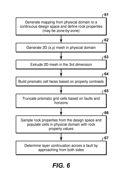
Fig. 6 is a flow chart showing basic steps in an embodiment of the present
inventive method for
generating a truncated grid; and
Fig. 7 is a flow chart showing basic steps in an embodiment of the present
inventive method for
generating a conforming prismatic grid.
[0013] All drawings except Figs. 1, 6 and 7 are black-and-white
reproductions of colored
originals due to patent law restrictions on the use of color.
[0014] The invention will be described in connection with example
embodiments. However,
to the extent that the following detailed description is specific to a
particular embodiment or a
particular use of the invention, this is intended to be illustrative only, and
is not to be construed
as limiting the scope of the invention. On the contrary, it is intended to
cover all alternatives,
modifications and equivalents that may be included within the scope of the
invention, as defined
by the appended claims.
4
CA 02948667 2016-11-09
WO 2016/018723 PCT/US2015/041831
DETAILED DESCRIPTION OF EXAMPLE EMBODIMENTS
[0015] Models of properties in a 3D domain are designed by, or under the
control of, a
human designer. To assist the property designer's work, the original domain is
mapped to a
design space where all the separate volumes are pieced together based on some
suitable
geometric criterion. Figure 1 illustrates the mapping process in a schematic
diagram. As a result
of the designer's work, the description of some physical property exists only
in the design space.
[0016] The grid of the original domain needs to be adapted to these
volumetric properties,
and material properties of the subsurface region need to be transferred onto
this grid. Thus, the
grid generation process includes a methodology for property sampling (through
the mapping to
the design space) and property feature reconstruction from this implicit
definition of the material
properties (composition of the mapping and functional property representation
in the design
space).
[0017] In the present invention, grid geometry is constructed only in the
physical space of
the model (as opposed to being built in a continuous space and mapped back to
the physical
space). The benefit is greater flexibility in handling complex geometries and
reduction of tedious
and non-intuitive geometric post-processing.
[0018] In more detail, the properties can be sampled along the sets of
parallel rays which can
be independent for different volumetric parts of the domain. The parallel rays
for sampling the
property are illustrated in Fig. 2A, and the sampled property along the rays
is illustrated in Fig.
2B. The internal material structure is detected as the change in sampled
properties. A grid is
adapted to this structure by resolving surfaces of sharp property contrast
with the cell faces; this
is illustrated in Fig. 2C. The grid can also be adapted to properties with
smoother value
distribution by some grid optimization approach that adjusts cell sizes based
on the property
values.
Example application: Gridding a model of a faulted subsurface reservoir
[0019] The present inventive method can be used to build a prismatic grid
resolving layered
media of a subsurface reservoir. The grid can be either truncated at the
bounding surfaces or
made to conform to the bounding surfaces of the 3D domain volumes, where the
bounding
surfaces are, for example, faults and horizons of a structural framework
delineating volumes of a
subsurface reservoir. In truncating a prismatic grid, the cells near the
domain boundaries are
CA 02948667 2016-11-09
WO 2016/018723 PCT/US2015/041831
truncated (or cut) by those bounding surfaces. In conforming a prismatic grid,
the cells are
constructed in such a manner that their faces always lie on (conform to) the
domain boundaries.
The grid can be used in modeling, e.g. of the fluid flow pathways through the
reservoir. This use
includes reservoir simulation studies in reservoir exploration, development or
production stages,
but the grid can also be used for any representation of a geologic model
description of a reservoir
structure and material properties.
[0020] Before the grid can be built, it is necessary to generate a mapping
to a continuous
design space using a known technique, e.g., companion US patent application
serial No.
62/073,465, entitled Methods to Handle Discontinuity in Constructing Design
Space Using
Moving Least Squares and companion US patent application serial No.
62/081,159, entitled
Handling Domain Discontinuity with the Help of Grid Optimization Techniques,
and define
geologic concept and rock properties in the design space where faults are
removed and
depositional layers are continuous (e.g., US patent application publication
No. 2013/0246031).
(These three references are incorporated herein in all jurisdictions that
allow it.) This is shown
as the first step (61 and 71) in each of the flow charts (Figs. 6 and 7) for
two different
embodiments of the present inventive method. This can be done by a zone of the
model, a zone
being a volume between two horizons. Thus, grid geometry generation is
repeated for each zone.
[0021] An advantage to the present inventive method is that the mapping
strategy may be
very simple and efficient because no reverse mapping (back to the functional
domain) is
required. The reverse mapping therefore can be ill-defined, for example two
points in the
physical domain may be mapped to the same point in the design space.
[0022] The designer's work in each continuous design space corresponds to
modeling a
stratigraphic geologic concept, as described, e.g., in US patent application
publication No.
2013/0246031, where the design space model of geologic concept contains a
description of
model regions and interfaces (surfaces) by means of mathematical functions.
Generation of
unstructured grids according to the present invention is discussed in more
detail grid (for a zone
or for the entire model volume) are as follows, with reference to the flow
chart of Fig. 6:
Step 62: Generate a 2D mesh (in the physical domain) in an (x,y) plane of a
bounding box
around a volume part (fault block) or an entire model volume. The mesh can be
adaptive to
some property or density control, as is illustrated in Fig. 4A. The bounding
box can be best
6
CA 02948667 2016-11-09
WO 2016/018723 PCT/US2015/041831
fitted to the volume part or to the entire model (by defining rotation
relative to an (x,y,z)
coordinate system).
Step 63: Extrude the 2D mesh through the physical domain in the third
dimension. The direction
for mesh extrusion can be different for each volume part (or fault block).
Even further, variable
extrusion directions can be built, adapting to a property gradient.
Step 64: Build prismatic cell faces based on property contrasts. A property
defining main
zonation/layer ID of a geologic concept may be sampled from the design space
and prismatic
grid faces may be constructed on the (implicitly defined) layer boundaries.
Layer definition and
reconstruction can be hierarchical based on the geologic concept, i.e., if
smaller-scale geobodies
are modeled as fully contained inside a main zone of the concept model, they
will be
reconstructed in a hierarchical manner after the main zone is reconstructed.
Optionally, grid
layers may be further subdivided with the standard layering options
(proportional, top- or
bottom-conforming).
Step 65: Prismatic grid cells may be truncated by the boundaries of the
volumetric pieces of the
domain (faults and horizons). Steps 62-65 are performed entirely in the
physical domain.
Step 66: Rock properties may be sampled onto the grid cells from the design
space. This is
illustrated in Fig. 4B. Various types of averaging can be used in sampling,
e.g. cell center,
arithmetic average of "vertical" edge centers, arithmetic or harmonic average
of quadrature
points.
Step 67: Connectivity of the cells along the contacts of volumetric domain
pieces (faults) may be
determined by computing intersections of cell faces coming from both sides of
the contact.
[0023] Basic steps in an embodiment of the present inventive method for
generating a
conforming prismatic grid (for a zone, fault-block (volume bounded by fault
surfaces and
containing multiple zones) or entire model volume) are as follows, with
reference to the flow
chart of Fig. 7:
Step 72: Generate a 3D parameterization of a model domain (zone, fault-block,
or entire model).
This step is specific to building a conforming grid, and is not required for
truncated grids. This
step and steps 73-76 are performed totally in the physical domain. See, for
example, companion
patent application serial No. 62/120,653, entitled "Methodology for
Parameterizing 3D Domain
with Discontinuities", which is incorporated herein in all jurisdictions that
allow it.
7
CA 02948667 2016-11-09
WO 2016/018723 PCT/US2015/041831
Step 73: Build a 2D areal grid of the domain (or, optionally, use the base
grid of the
parameterization). Use existing methods, such as is disclosed in US Patent No.
7,932,904, which
is incorporated herein in all jurisdictions that allow it. The 2D mesh can be
adaptive to some
property or density control, as is illustrated in Fig. 5A.
Step 74: Extrude the 2D mesh through the physical domain in the third
dimension according to
the pillars of the parameterization.
Step 75: Build prismatic cell faces based on property contrasts. (same as in
step 64 in Fig. 6). A
property defining main zonation/layer ID of a geologic concept may be sampled
from the design
space and prismatic grid faces may be constructed on the (implicitly defined)
layer boundaries.
Layer definition and reconstruction can be hierarchical based on the geologic
concept, i.e., if
smaller-scale geobodies are modeled as fully contained inside a main zone of
the concept model,
they may be reconstructed in a hierarchical manner after the main zone is
reconstructed.
Optionally, grid layers may be further subdivided with the standard layering
options
(proportional, top- or bottom-conforming).
Step 76: Prismatic grid cells conform to fault surfaces as a result of the
parameterization; they
can be either (a) truncated by horizon surfaces or (b) conformed to (form a
pinch-out with)
horizons.
Step 77: Rock properties may be sampled onto the grid cells from the design
space (same as step
66). This is illustrated in Fig. 5B. Various types of averaging can be used in
sampling, e.g. cell
center, arithmetic average of "vertical" edge centers, arithmetic or harmonic
average of
quadrature points.
Step 78: Connectivity of the cells along the contacts of volumetric domain
pieces (faults) may be
determined by computing intersections of cell faces coming from both sides of
the contact. (same
as step 67).
[0024] Conformal grids are preferable for reservoirs with near-vertical
faults, and truncated
grid are preferable for more complex reservoir structures that include, for
example, x- or y-
faults, or nearly horizontal faults.
[0025] For a multi-zonal model, which is built zone-by-zone with different
areal 2D grid
resolutions for each zone, a final step of consolidation needs to be performed
after grid
geometries are generated in each zone of the model. In this consolidation
step, connectivity of
8
CA 02948667 2016-11-09
WO 2016/018723 PCT/US2015/041831
cells along the contacts of zones (horizons and faults) is established similar
to steps 67 and 78).
This consolidation is illustrated for a truncated grid in Fig. 3.
[0026]
As will be readily apparent to all persons who work in the technical field,
all
practical applications of the present inventive method are performed using a
computer,
programmed in accordance with the disclosures herein.
[0027]
The foregoing description is directed to particular embodiments of the present
invention for the purpose of illustrating it. It will be apparent, however, to
one skilled in the art,
that many modifications and variations to the embodiments described herein are
possible. All
such modifications and variations are intended to be within the scope of the
present invention, as
defined by the appended claims.
9