Note: Descriptions are shown in the official language in which they were submitted.
CA 02952132 2016-12-16
1
Method for allocating radio resources in a communication system using
non-GS0 satellites with interference level constraint to a geostationary
system
The invention relates to the field of satellite communication systems
and in particular the systems that use non-GSO satellites, for example
satellites in low earth orbit.
The invention relates to a method for allocating radio resources in a
communication system using non-GSO satellites operating in frequency
bands reserved for geostationary systems. The invention concerns the taking
into account, in the method for allocating radio resources, of the
interference
level generated by the system with non-GS0 satellites to any communication
system, using geostationary satellites.
The regulations concerning satellite radio communications make it
possible to deploy non-geostationary systems in frequency bands previously
reserved for the systems based on geostationary satellites.
However, the coexistence of two satellite communication systems
using, totally or partially, the same frequency bands, poses a problem of
management of the interference generated by one system to another. In this
case, the geostationary system is likely to be disturbed, even interfered
with,
by the transmissions between satellites and ground stations belonging to the
non-geostationary system.
To guarantee a given quality of service for a geostationary
communication system, the International Telecommunications Union (ITU)
has set a maximum authorised interference level for the geostationary
telecommunication systems as a whole and originating from systems
coexisting on the same frequency bands and using non-geostationary
satellites.
To ensure that a non-geostationary system does not generate an
interference level above an authorised threshold, one solution consists in
setting, for the set of links between the ground terminals and the non-
CA 02952132 2016-12-16
2
geostationary satellites, a separation angle threshold to be observed with
respect to the geostationary arc. The geostationary arc designates the view
of the geostationary orbit from the earth.
A terminal of the non-geostationary system is authorised to set up a
communication link (uplink, down link or two-way) with a non-geostationary
satellite if, and only if, its separation angle is greater than or equal to
the
separation angle threshold set and independently of the other links set up by
the other terminals. Thus, each terminal sees the number of non-
geostationary satellites with which it can potentially communicate being
reduced. In particular, the non-geostationary systems can use spectral
resources in band Ka and the terminals of these systems can operate with
very low elevation angles. Such conditions bring about the requirement to
use very high transmission powers. Such power levels then necessitate the
use of a separation angle of high value so as not to interfere with the
geostationary systems co-existing on the same band Ka. Typically, a
separation angle threshold value of the order of 7 degrees is used to satisfy
all these constraints. Unfortunately, the use of a separation angle with a
value that is fixed to a constant and high value causes the geographic
coverage provided by the non-geostationary system to be reduced.
A simple solution making it possible to ensure a level of service and a
geographic coverage that are sufficient for the non-geostationary system
while observing the recommended separation angle threshold consists in
increasing the number of non-geostationary satellites in the constellation of
the system. Thus, an average number of satellites available for each terminal
is assured while the terminal-satellite links which are not compatible with
the
separation angle threshold are prohibited.
However, the increase in the number of non-geostationary satellites
presents drawbacks of cost overheads for the design of the overall system
and also of sub-optimality because the set of communication resources
available is not fully used because of the impediment linked to the
coexistence with the geostationary systems.
CA 02952132 2016-12-16
3
One static method described in the patent application
US 2003/0073404 Al proposes avoiding the alignments of the earth/space
radio frequency links between a new non-geostationary system (system B)
and other existing geostationary systems (systems A) sharing the same
frequency band.
This method is based on taking into account predictive constraints
such as the orbits of the satellites and the radio frequency characteristics
of
the stations and of the satellites of the systems A and B.
This static method is valid for systems operating in the low frequency
bands such as band Ku. In effect, for this type of system, the geometrical
aspect alone makes it possible to statically and deterministically schedule
the
earth/space radio frequency links to be used by the system B without causing
interference on the other existing systems A and while ensuring the quality of
service expected for the system B.
This strategy is justified when the atmospheric attenuations are
negligible (which is the case with the systems using low frequency bands).
This static method is however no longer appropriate for a new system
B operating in high frequency bands such as band Ka. In effect, the use of
low elevations combined with high atmospheric attenuations, like those
induced by rain, imposes an excessive over-dimensioning in terms of power
required onboard and at the ground level of the infrastructure of the system B
in order to ensure the expected quality of service.
A variant of the above method consists in forcing the earth/space radio
frequency links of the new system B to be able to be implemented only when
the satellites of the system B are seen by the stations of the system B with a
high elevation angle. This makes it possible to reduce the dynamic range of
the atmospheric attenuations even in high frequency bands like the band Ka.
Nevertheless, this strategy imposes an over-dimensioning in terms of
the number of satellites to be deployed by the system B in order to ensure
the rate of visibility required thereby. This over-dimensioning has a strong
CA 02952132 2016-12-16
4
impact on the cost and the deployment of the ground and onboard
infrastructures of the system B.
The present invention proposes remedying the abovementioned
drawbacks by a method for allocating radio resources, in a communication
system using non-GS satellites, which defines, dynamically, a separation
angle threshold to be observed for each terminal as a function of an overall
interference level generated to the geostationary systems.
The invention makes it possible to maximize the geographic coverage
by minimizing the number of satellites in the constellation of the non-
geostationary system while ensuring that the interference level induced to the
geostationary systems using totally or partially identical frequency bands
does not exceed the regulatory threshold.
The subject of the invention is a method for allocating radio resources
for setting up satellite communications in a first communication system
comprising a constellation of non-GSO satellites and a first set of terminals,
the method comprising the following steps, for each terminal of the first set:
- determining a distinct separation angle threshold to be observed
with respect to a constellation of geostationary satellites, a
separation angle being defined as the smallest topocentric angle
by which a given non-GS satellite and any geostationary satellite
of the geostationary arc are seen from a given terminal of the first
set,
- authorising the terminal to set up a communication link with a non-
GS0 satellite if the separation angle associated with said link is
greater than or equal to the separation angle threshold.
According to a particular aspect of the invention, the distinct separation
angle threshold to be observed for each terminal of the first set is
determined
in such a way that the set of authorised communication links generates, on a
geostationary satellite communication system, an interfering power level
conforming to a regulatory limit.
CA 02952132 2016-12-16
According to a particular aspect of the invention, the determination of a
separation angle threshold comprises:
- the computation of at least one interfering power level generated
by the set of communication links between the terminals of the first
5 set and the non-GSO satellites to a geostationary satellite
communication system,
- the iterative search, for each terminal of the first set, for the
minimum separation angle threshold value making it possible to
keep said at least one computed interfering power level in
io accordance with a regulatory limit.
According to a particular aspect of the invention, the determination of a
separation angle threshold comprises an initialisation phase consisting in
assigning an initial value to the separation angle threshold, for each
terminal,
and in declaring each terminal a candidate for the lowering of its separation
angle threshold.
According to a particular aspect of the invention, said iterative search
comprises, for each terminal and on each iteration, the association of said
terminal with a non-GSO satellite observing the separation angle threshold
determined on the current iteration and for which the separation angle is
closest to said threshold, the iterations being continued as long as at least
one terminal is a candidate for the lowering of its separation angle
threshold.
According to a particular aspect of the invention, the communication links
between the terminals of the first set and the non-GS satellites are two-way
or one-way uplinks and said iterative search comprises the computation of a
first interfering power level generated by the set of communication uplinks to
the geostationary arc for a set of assumed positions of geostationary
satellites.
According to a particular aspect of the invention, the computation of said
first interfering power level is determined by choosing, for each
geostationary
satellite, a pointing direction which makes it possible to maximize the value
of
said first interfering power level.
CA 02952132 2016-12-16
6
According to a particular aspect of the invention, said iterative search
comprises the search for at least one geostationary satellite for which the
first
computed interfering power level is not in accordance with said regulatory
limit.
According to a particular aspect of the invention, the communication links
between the terminals of the first set and the non-GSO satellites are one-way
down links and said iterative search comprises the computation of a second
interfering power level generated by the set of communication down links to a
set of assumed positions of terminals belonging to a geostationary satellite
io communication system.
According to a particular aspect of the invention, the communication links
between the terminals of the first set and the non-GSO satellites are two-way
and said iterative search comprises the computation of a second interfering
power level generated by the set of communication down links to a set of
assumed positions of terminals belonging to a geostationary satellite
communication system.
According to a particular aspect of the invention, the computation of said
second interfering power level is determined by choosing, for each terminal
belonging to a geostationary satellite communication system, a pointing
direction which makes it possible to maximize the value of said second
interfering power level.
According to a particular aspect of the invention, said iterative search
comprises the search for at least one terminal belonging to a geostationary
satellite communication system for which the second computed interfering
power level is not in accordance with said regulatory threshold.
According to a particular aspect of the invention, said iterative search
comprises, for each first or second computed interfering power level not in
accordance with said regulatory threshold, the search for at least one pair
(terminal of the first set, non-GS0 satellite) whose contribution, in the
value
of the first or the second interfering power level, is highest.
CA 02952132 2016-12-16
7
According to a particular aspect of the invention, said iterative search
comprises, for each terminal of the pair (terminal of the first set, non-GS0
satellite) retained, the re-establishment of the separation angle threshold
determined on the preceding iteration and the removal of said terminal from
the list of the candidates for the lowering of the separation angle threshold.
According to a particular aspect of the invention, said iterative search
comprises, for at least one terminal of the pair (terminal of the first set,
non-
GSO satellite) retained, the adaptation of the RE characteristics of at least
one link involving said terminal and a non-GS0 satellite, so as to reduce the
interfering power level of the set of authorised communication links on a
geostationary satellite communication system.
According to a particular aspect of the invention, the iterative search
comprises a verification of the conformity of the first interfering power
level
and/or of the second interfering power level and, if the conformity is borne
out, the lowering of the separation angle threshold by a predetermined value,
for each terminal that is a candidate for the lowering of its separation angle
threshold.
According to a particular aspect of the invention, the iterative search is
stopped when there is no longer any terminal that is a candidate for the
lowering of its separation angle threshold.
Another subject of the invention is a device for allocating radio resources
for setting up satellite communications comprising means, including at least
one processor and one memory, configured to implement the method for
allocating radio resources according to the invention.
Another subject of the invention is a computer programme comprising
instructions for executing the method for allocating radio resources for
setting
up satellite communications according to the invention, when the programme
is run by a processor.
Another subject of the invention is a processor-readable storage medium
on which is stored a programme comprising instructions for executing the
CA 02952132 2016-12-16
8
method for allocating radio resources for setting up satellite communications
according to the invention, when the programme is run by a processor.
Other features and advantages of the present invention will become
more apparent on reading the following description in conjunction with the
attached drawings which represent:
- Figure 1, a block diagram representing the context of application of the
invention,
- Figure 2, a flow diagram detailing the steps of a method for designing
a non-geostationary satellite communication system according to the
invention,
- Figure 3, a flow diagram detailing the steps of a method for allocating
radio resources according to the invention,
- Figure 4, a flow diagram detailing the steps of a function for
dynamically determining a separation angle threshold, according to a
first embodiment of the invention,
- Figure 5a, a diagram illustrating an exemplary computation of global
interferences relating to the uplinks,
- Figure 5b, a diagram illustrating an exemplary computation of global
interferences relating to the down links,
- Figure 6, a flow diagram detailing the steps of a function for
dynamically determining a separation angle threshold, according to a
second embodiment of the invention applied to the uplinks,
- Figure 7, a flow diagram detailing the steps of a function for
dynamically determining a separation angle threshold, according to a
second embodiment of the invention applied to the down links.
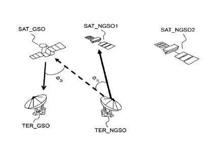
Figure 1 schematically represents an exemplary scenario of
application of the invention comprising a first communication system using
non-GSO satellites and a second satellite communication system which is a
geostationary system. The first communication system comprises a plurality
of satellites SAT NGS01, SAT NGSO2 and a set of terminals on the ground
CA 02952132 2016-12-16
9
TER NGS01, TER _NGS02. The terminals can be fixed or non-GSO and are
capable of communicating with each satellite of the system by an uplink or a
down link or a two-way link LR1, LR2. Similarly, the second geostationary
communication system comprises a plurality of geostationary satellites and a
set of terminals. To simplify, Figure 1 shows only one satellite SAT_GS0 and
one terminal TER GSO forming the second communication system and
communicating with one another via a link by satellite LRGEO.
A terminal can be any network equipment capable of exchanging and
communicating via a wireless link with a satellite. It can be in particular a
fixed or portable computer, a fixed or portable telephone, a personal digital
assistant, a server or even a modem for accessing the internet by satellite.
The first satellite communication system and the second satellite
communication system are able to set up communications in totally or
partially identical frequency bands. An example of frequency band used is
the Ka band. Another example is the Ku band.
The first satellite communication system further comprises a satellite
station ST RRM comprising a control subsystem responsible for managing
the allocation of communication resources within the system. The present
invention can be implemented in the control subsystem.
The invention can be implemented on the basis of hardware and/or
software elements. It can notably be implemented as a computer programme
comprising instructions for the execution thereof. The computer programme
can be stored on a processor-readable storage medium. The medium can be
electronic, magnetic, optical or electromagnetic.
The invention can also be implemented by a device of the control
subsystem type embedded in a satellite station, the device comprising a
processor and a memory. The processor can be a generic processor, a
specific processor, an application-specific integrated circuit (known by the
acronym ASIC) or a field-programmable gate array (known by the acronym
FPGA).
CA 02952132 2016-12-16
The device can use one or more dedicated electronic circuits or a
general-purpose circuit. The technique of the invention can be implemented
on a reprogrammable computation machine (a processor or a microcontroller
for example) running a programme comprising a sequence of instructions, or
5 on a dedicated computation machine (for example a set of logic gates like an
FPGA or an ASIC, or any other hardware module).
As an example of hardware architecture suitable for implementing the
invention, a device according to the invention can comprise a communication
bus to which are linked a central processing unit (CPU) or microprocessor, a
10 read only memory (ROM) being able to comprise the programmes necessary
for the implementation of the invention; a random access memory (RAM) or
cache memory comprising registers suitable for storing variables and
parameters created and modified during the execution of the
abovementioned programmes; and a communication or I/O (input/output)
interface suitable for transmitting and receiving data.
A definition of an angle, identified in Figure 1, is now introduced. This
angle is used hereinbelow to explain the embodiments of the invention.
An angle at hereinafter designated topocentric angle is considered. As
a reminder, a topocentric angle is an angle by which two given points are
seen from a specific point on the earth. The particular topocentric angle at
considered in the context of the invention is an angle formed by the direction
between a terminal and a satellite of the first system and by the direction
between this same terminal and a satellite of the geostationary system.
Figure 1 shows, by way of example, the topocentric angle atil associated
with the terminal TER_NGS01 and with the satellites
SAT NGS01,SAT GSO. Also represented is the topocentric angle 0t22
associated with the terminal TER NGS02 and with the satellites
SAT_NGS02,SAT_GSO.
The concept of separation angle is also defined, for a link between a
terminal of the first system TER_NGS01,TER_NGS02 and a non-GS0
satellite of the first system SAT_NGS01,SAT_NGS02 as being the smallest
CA 02952132 2016-12-16
11
topocentric angle obtained by varying the position of a geostationary
satellite
over the set of possible points of the geostationary arc.
In other words, the separation angle is defined as being the minimum
angle by which a non-GSO satellite of the first constellation and any
geostationary satellite are seen from a terminal of the first communication
system.
The term separation angle is used because this angle defines the
proximity between the link linking a terminal of the first system with a non-
GSO satellite of the first constellation and the geostationary satellites. The
lower this angle, the greater the likelihood of this link interfering on the
geostationary satellites and also on the terminals on the ground of the
geostationary systems. In particular, the interference generated on the
geostationary satellites originates from the signal transmitted by a terminal
of
the first constellation to space, in other words over the Earth to space
uplink.
Figure 1 schematically shows the interferences INT_M_1 generated by the
terminal TER_NGS01 on the geostationary satellite SAT_GS0 and the
interferences INT _ M _2 generated by the terminal TER_NGS02 on the
geostationary satellite SAT_GSO.
Similarly, the interference generated on the ground terminals
TER_GS0 belonging to geostationary systems originates from the signal
transmitted by a non-GSO satellite of the first communication system, in
other words from the space to Earth down link. In Figure 1, the interferences
INT_D_1 generated by the satellite SAT_NGS01 to the terminal TER_GS0
of the geostationary system are also identified, as are the interferences
INT_D_2 generated by the satellite SAT_NGS02 to this same terminal
TER_GSO.
As indicated in the preamble, a solution that makes it possible to
observe a regulatory interference level consists in setting a threshold for
this
separation angle, for example a threshold equal to 7 , below which the link
between a terminal and a satellite of the first system is prohibited, then
CA 02952132 2016-12-16
12
making it necessary to select another satellite, to set up a link with the
terminal, so as to observe a separation angle greater than the threshold set.
It should be noted that the term "separation angle" can also be
replaced by "avoidance angle".
The invention proposes a method for dynamically configuring the
thresholds applied to the separation angles to improve the allocation of
communication resources available within the first communication system
while guaranteeing observance of the regulatory interference level generated
on the geostationary satellite communication systems.
Figure 2 schematically represents a flow diagram detailing the steps of
a method for designing a satellite communication system according to the
invention. The overall function of this method is the static management of
radio resources of the system. Such a function is usually referred to by the
expression "static radio resources management".
In a first step 201, a satellite operator provides a request for needs of
a communication system which comprises needs in terms of quality of
service, overall availability, overall bit rate, error rates or other general
operating characteristics of such a system.
In a second step 202, the impact of the local atmospheric conditions
on each terminal likely to be incorporated in the system is evaluated. This
evaluation can be done by characterizing the level of attenuation of the
signal
received or transmitted by a terminal as a function of the elevation of the
terminal.
In a third step 203, a link budget is computed both for the uplinks and
the down links of the system. The computation of the link budget notably
takes as input parameter the maximum attenuation level as a function of
elevation for each terminal. For the uplink, the link budget can be evaluated
by a computation of the equivalent isotropic radiated power (EIRP) required
at the terminal. For the down link, the link budget can be evaluated by a
computation of the G/T signal-to-noise ratio required at the terminal.
CA 02952132 2016-12-16
13
In a fourth step 204, the particular characteristics of the terminals to be
deployed are evaluated to satisfy the link budget. Such characteristics can
notably include the type of antenna or the type of amplifier embedded in the
terminal. Furthermore, additional signal processing functionalities can be
incorporated in the terminals of the system in order to combat the
atmospheric attenuations of the signal.
In a fifth step 205, whether or not the needs of the operator can be
satisfied is verified by taking into account the characteristics of the
terminals
selected at the end of the step 204 and by taking into account the attenuation
bands of the signal as a function of the elevation bands of the different
terminals.
If the needs of the connections 200 cannot be satisfied, a negotiation
is set up with the operator to reduce the requirements in terms of quality of
service or of bit rate.
If, however, the needs of the connections 200 are satisfied, then the
needs for setting up communications between the terminals and the satellites
are validated and there is a transition, via a step 206, to a radio resource
allocation process. The step 206 consists in listing, for each terminal of the
system, its radio frequency characteristics and the bit rate required.
Figure 3 details, in a flow diagram, the steps of the resource allocation
method according to the invention.
The overall function of this method is dynamic management of radio
resources of the system, or "dynamic radio resources management". In
particular, the allocation of radio resources is performed over time by taking
into account the dynamic trajectories of the non-geostationary satellites.
The method begins at the step 206 which analyses the number, the
type, the location, the radio frequency characteristics and the bit rate
required
of each of the terminals of the system determined at the end of the design
method described in Figure 2.
In a step 208, the radio resources available for each terminal are
identified. In other words, the satellites of the constellation of the system
CA 02952132 2016-12-16
14
which are in line of sight from each terminal and which observe a determined
separation angle threshold are identified, for each terminal, via the step 207
described in more detail hereinbelow. For each satellite, the identification
of
the radio resources can also comprise the identification of the frequency
carriers which can be used to communicate and the number and the type of
the antennas embedded onboard the satellite, in particular the polarization of
the antennas.
At the end of the step 208, a list of satellites and of associated radio
resources which can potentially be used by each terminal is obtained.
In a step 209, a sort is performed, for each terminal, in the list of the
satellites obtained in order to establish an order of priority for the
allocation of
radio resources. The priorities are defined on the basis of a score assigned
to
each link, the score being determined notably as a function of a link budget
computation which can be supplied by the step 203 of the design method
described in Figure 2.
In a step 210, an allocation of radio resources is then performed for
each terminal as a function of the priority score assigned in the step 209.
The steps 208 and 210 are performed notably on the basis of the
operational constraints of the system 301.
In a step 211, all the active radio links are aggregated on the basis of
the results of the resource allocation step 210. In other words, all the
uplinks
and the down links between the terminals and satellites are identified in
order
to have an overview of the active radio links.
In a step 207, there is then dynamically determined, according to the
invention, for each terminal, a separation angle threshold which makes it
possible to observe the overall needs in terms of bit rates required while
observing the interference level constraints on the geostationary satellite
communication systems operating on the same frequency bands. This step
207 notably takes as input, the characteristics of the constellation of the
satellites of the system, notably the positions of the non-GSO satellites, but
CA 02952132 2016-12-16
also the regulatory interference level constraints and the characteristics of
the geostationary systems that are to be preserved.
The determination of a separation angle threshold to be observed for
each terminal notably takes into account a computation of overall
5 interference level from the first system to the geostationary arc and to the
ground stations.
The step 207 then provides, in the step 208, for the next iteration of
the method, a separation angle threshold to be observed for each terminal to
set up a link with a satellite, so as to observe the regulations imposed for
the
10 overall interference level.
The steps 208, 209, 210 are then iterated by eliminating, from the list
of the satellites available for each terminal, those which do not make it
possible to obtain a separation angle greater than or equal to the separation
angle threshold.
15 The radio resource allocation step 210 can thus lead to the
assignment to a terminal of satellites other than those chosen initially or on
the preceding iteration.
According to a particular aspect of the invention, the links between
terminals and satellites can be two-way or one-way. A terminal can be
authorised to communicate with two different satellites over the uplink and
over the down link or, on the contrary, the two links can be linked together
in
a single two-way link between a terminal and a satellite.
If the links between terminals and satellites are two-way, then the step
207 of the method according to the invention consists in determining a
separation angle threshold associated with each terminal.
If, on the contrary, a terminal can communicate over an uplink with a
satellite and over a down link with another satellite, then the step 207 of
the
method is duplicated to determine a first separation angle threshold
applicable to each terminal for the uplinks and a second separation angle
threshold applicable to each terminal for the down links.
CA 02952132 2016-12-16
16
The radio resource allocation method according to the invention
described in Figure 3 can be executed with a given rate or in response to an
event in the life of the system, for example the entry or the exit of a
terminal.
Figure 4 illustrates a first exemplary embodiment, according to the
invention, of the method for dynamically determining a separation angle
threshold for each terminal, executed in the step 207. According to this first
example, the links between terminals and satellites of the first communication
system are considered two-way, that is to say that a terminal communicates
with one and the same satellite over the uplink and over the down link. In a
first step 401, the active terminals of the first communication system are
identified as are the non-GS0 satellites of the first constellation with which
they can communicate according to the list established at the end of the step
208 of the radio resource allocation method described in Figure 3.
For each active terminal, an initial predefined threshold value to be
observed for the separation angle is set. This threshold can, for example, be
set at a value of 7 . In a step 402, all the active terminals are then
declared
candidates for the potential lowering of their separation angle threshold.
This
declaration can be made, for example, through a vector or a table in which
are listed the active terminals identified by a numeric identifier and a
binary
information item indicating whether or not the terminal is candidate for the
potential lowering of its separation angle threshold.
In a step 403, there is associated, with each terminal of the first
system, a satellite of the first constellation which observes the separation
angle threshold set in the preceding step and which corresponds to the
separation angle closest to the threshold. At the end of the step 403, there
is
therefore obtained, for each terminal, an associated satellite such that the
link between this terminal and this satellite observes the separation angle
threshold while minimizing the value of the separation angle. In some cases,
no satellite can be retained because no satellite makes it possible to observe
the initial separation angle threshold set. This scenario is dealt with in a
variant embodiment of the invention described later.
CA 02952132 2016-12-16
17
The method then continues with the steps 404 and 405 in which a
computation of worst case total interference level is performed. The concept
of "worst case" computation consists in performing this computation for a
minimum separation angle, identified in the preceding step 403, closest to the
threshold considered for each terminal. According to the first exemplary
embodiment of the method for determining a separation angle threshold
described in Figure 4, a first worst case total interference level computation
for the uplinks between terminals and satellites of the first communication
system is performed in the step 404 and a second worst case total
interference level computation for the down links between satellites and
terminals of the first communication system is performed in the step 405. The
first and the second interference level computations are performed by
aggregating the interference level contributions for each active terminal (for
the uplink) or for each active satellite (for the down link).
The first interference level computation relates to the interferences
generated by the transmissions from the active terminals to space on the
satellites of the geostationary arc. These are interferences of those
referenced INT _ M _ 1 , INT_ M _2 in Figure 1.
The second interference level computation relates to the interferences
generated by the transmissions from the active satellites to Earth on the
terminals belonging to the geostationary satellite communication systems.
These are interferences of the type of those referenced INT_D_1, INT_D_2
in Figure 1.
The total interference level generated can be computed through an
equivalent power flux-density computation.
The equivalent power flux-density computation can, for example, be
performed using the method described in ITU-R recommendation S.1325-3
from the International Telecommunications Union which is referenced here.
According to this recommendation, the equivalent power flux density
epfd is defined as being the sum of the power flux densities produced on a
reception station of a system with interference (situated on the surface of
the
CA 02952132 2016-12-16
18
Earth or in orbit, depending on the case) from all the transmission stations
of
an interfering system, given the off-axis discrimination of a reference
reception antenna that is assumed to be pointed in its nominal direction.
In the present case, the interfering system is the first non-GSO
satellite communication system and the system with interference is a
geostationary satellite communication system.
Figure 5a represents, in a diagram, a terminal TER_NGS0 and two
satellites SAT_NGS01, SAT_NGS02 of the first communication system and
a terminal TER_3S0 and a satellite SAT_GS0 of a geostationary system.
io The next paragraph explains an example of computation 404 of the
equivalent power flux density epfd_up computed for the interferences
produced by the transmissions from the terminal TER_NGS0 to the satellite
SAT GS0 of the geostationary system.
For each position of the geostationary arc, the equivalent power flux
density epfd_up for the uplinks (first interference level computation 404) can
be computed via the following relationship (1):
( (C ____
epfd up 1-N G11) Gr(CO2,) 10logjo I10" (1)
47C R,2 G
in which:
Na is the number of terminals of the first communication system visible
from a geostationary satellite (in Figure 5a, just one terminal TER_NGS0 is
represented),
i is the index of the terminal considered belonging to the first
communication system,
Pi is the RE power at the input of the antenna of the terminal
TER NGSO considered belonging to the first communication system (dBW),
G1(co1i) is the gain of the transmission antenna of the terminal
TER NGSO considered belonging to the first communication system towards
a geostationary satellite SAT_GSO,
CA 02952132 2016-12-16
19
Gr(Co2i) is the gain of the reception antenna of a geostationary satellite
SAT_GSO towards the 1st terminal considered of the first communication
system TER_NGSO,
Grmax is the maximum gain of the antenna of a geostationary satellite
SAT_GSO,
(ph, is the angle between the line of sight of the terminal TER_NGSO
considered (index i) belonging to the first communication system and the
direction between the terminal TER_NGSO and a geostationary satellite
SAT_GSO (angle represented in Figure 5a),
(p21 is the angle between the line of sight of a geostationary satellite
SAT_GSO and the direction between this satellite SAT_GSO and the 1st
terminal TER_NGSO considered of the first communication system (angle
represented in Figure 5a),
Ri is the distance between the terminal TER_NGSO considered of the
first communication system and the geostationary satellite SAT_GSO.
The computation of the equivalent power flux density epfd_up for the
uplinks is performed for all the points of the geostationary arc with an
appropriate sampling. The pointing direction of the geostationary satellite
SAT_GSO, in other words the value of the angle (p21, is chosen so as to
maximize the value of the interference level epfd_up. The pointing direction
of the terminal of the first system TER_NGSO, in other words the value of the
angle (phi, is given by the direction between this terminal TER_NGSO and the
satellite SAT NGSO selected in the step 403 (satellite which makes it
possible to minimize the separation angle).
The value of the separation angle threshold has an influence both on
the angle (phi and on the angle 921 since this value defines the relative
separation of the non-GSO satellite SAT_NGS0 relative to the geostationary
satellite SAT_GSO. Consequently, the value of the separation angle
threshold has an influence on the gain of the reception antenna of a
geostationary satellite SAT_GSO in the line of sight of the terminal
CA 02952132 2016-12-16
TER NGSO of the first system and on the gain of the transmission antenna
of the terminal TER NGSO of the first system in the line of sight of the
geostationary satellite SAT_GSO.
Figure 5b represents, in a diagram, two terminals TER_NGS01,
5 TER NGS02 and a satellite SAT NGSO of the first communication system
and a terminal TER GS and a satellite SAT GSO of a geostationary
system. The next paragraph explains an example of computation 405 of the
equivalent power flux density epfd_down computed for the interferences
produced by the transmissions from the satellite SAT_NGS0 to the terminal
10 TER GSO of the geostationary system.
Similarly, for each terminal TER_GS0 placed on a point of the surface
of the earth, the equivalent power flux density epfd_down for the down links
(second interference level computation 405) can be computed via the
relationship (2), identical to the relationship (1) but applied to the
following
15 variables:
(J=Nh p. G' (Co' if) (co' 2.1)\
epfd down = 10logio Eio (2)
47c J2 G'
j=1
Nb is the number of satellites of the first constellation visible from a
terminal belonging to the geostationary system (in Figure 5b, a single
satellite
20 SAT NGSO has been represented for purely illustrative purposes),
P) is the RF power at the input of the antenna of the satellite
SAT NGSO considered belonging to the first constellation (dBW),
) is the gain of the transmission antenna of the satellite
SAT NGSO considered belonging to the first constellation towards a terminal
TER GS0 belonging to the geostationary system,
G',. (q",) is the gain of the reception antenna of a terminal TER_GS0
belonging to the geostationary system towards the 1st satellite SAT_NGS0
considered of the first constellation,
CA 02952132 2016-12-16
21
G' is the
maximum gain of the antenna of a terminal TER_GS0 of
the geostationary system,
(V1i is the angle between the line of sight of the satellite SAT_NGS0
considered (index i) belonging to the first constellation and the direction
between this satellite SAT_NGS0 and a terminal TER_GS0 belonging to the
geostationary system (angle represented in Figure 5b),
(p'2i is the angle between the line of sight of a terminal TER_GS0
belonging to the geostationary system and the direction between this terminal
TER GSO and the 1st satellite SAT NGSO considered of the first
constellation (angle represented in Figure 5b),
R'i is the distance between the satellite SAT_NGS0 considered of the
first constellation and the terminal TER GS0 of the geostationary system.
The relationship (2) is applied for a set of assumed positions of
terminals of a geostationary system according to a predefined and
appropriate meshing of the surface of the Earth. The pointing direction of the
terminal TER GSO belonging to the geostationary system, in other words the
value of the angle (p'2i, is chosen so as to maximize the value of the
interference level epfd_down. The pointing direction of the satellite
SAT NGSO, in other words the value of the angle is the
pointing
direction of the satellite SAT NGSO selected in the step 403 (satellite which
makes it possible to minimize the separation angle) to the terminal
TER_NGS0 considered.
The value of the separation angle threshold influences both the angle
cp'ii and the angle (p'2; since this value defines the relative separation of
the
non-GS0 satellite SAT_NGS0 relative to the geostationary satellite
SAT GSO. Consequently, the value of the separation angle threshold has an
influence on the gain of the reception antenna of a terminal TER_GS0
belonging to the geostationary system in the line of sight of the satellite
SAT NGSO of the first system and on the gain of the transmission antenna
CA 02952132 2016-12-16
22
of the satellite SAT NGSO of the first system in the line of sight of the
terminal TER GSO.
The method continues with the application of a step 406 consisting in
testing conformity of the interference levels computed in the steps 404 and
405 with limits specified by regulations, for example by the International
Telecommunications Union.
In the step 406, a first conformity test is applied for the uplinks,
consisting in comparing the first total interference level Epfd_up with a
first
regulatory limit. Similarly, a second conformity test is applied for the down
links, consisting in comparing the second total interference level Epfd_down
with a second regulatory limit.
The conformity tests of the step 406 can more generally consist in
evaluating whether the first total interference level Epfd_up and the second
total interference level Epfd_down are acceptable or not from the point of
view of the operation of the geostationary systems.
If the two conformity tests performed in the step 406 conform, in other
words if the two total interference levels are each below the regulatory
limits
over the entire geostationary arc and for all the assumed positions of
terminals of a geostationary system, then the method continues with a step
407 which consists in reducing, by a predetermined value, the value of the
separation angle threshold for each terminal that is a candidate for the
lowering of its threshold.
Following the step 407, the method restarts at the step 403 for a new
iteration.
The lowering of the separation angle threshold is possible here
because the total interference level generated by setting the separation angle
threshold at the initial value established in the first step 401 does not
exceed
the regulatory limits.
If, on the contrary, one of the two conformity tests performed in the
step 406 does not conform, the method continues with the steps 408 and/or
409.
CA 02952132 2016-12-16
23
If the first conformity test, concerning the uplinks, does not conform, in
other words if the first total interference level Epfd_up is above the first
regulatory threshold for at least one point of the geostationary arc, the
method continues with a step 408 which consists in identifying the
geostationary satellites, in other words the points of the geostationary arc,
which are subject to a non-conforming interference level.
If the second conformity test, concerning the down links, does not
conform, in other words if the second total interference level Epfd_down is
above the second regulatory threshold for at least one assumed position of a
terminal of a geostationary system, the method continues with a step 409
which consists in identifying the terminals of the geostationary systems, in
other words the points of the meshing of the Earth, which are subject to a
non-conforming interference level.
The method continues with the step 410 in which, for each non-
conformity recorded, the pairs (terminal, satellite) of the first system (as
created at the end of the step 403) for which the contribution, in the total
interference computation, is highest, are identified. This search is performed
independently for the interference level computation associated with the
uplinks epfd_up and for the interference level computation associated with
the down links epfd_down. This search can be done by separately evaluating
the terms of the sums involved in the relationships (1) and (2), in other
words
the interference levels computed for each of the Na terminals (for the
uplinks)
or each of the Nb satellites (for the down links), and by searching for the
pairs
(terminal, satellite) which produce the highest interference level for each of
the two conformity tests.
At the end of the step 410, there is therefore obtained a list of
terminals of the first system which exhibit a separation angle threshold which
generates a non-regulatory interference level on the geostationary systems.
In a step 411, for each terminal of the list identified in the step 410, the
value of the separation angle threshold is restored to the value set on the
CA 02952132 2016-12-16
24
preceding iteration then the terminal is removed from the list of the
terminals
that are candidates for the lowering of their separation angle threshold.
In a step 412, a check is carried out to see if the list of the terminals
that are candidates for the lowering of their separation angle threshold is
empty, and, if it is, the method goes on to step 413 which consists in
updating, for each terminal, the value of the separation angle threshold to
the
last value set.
If this list 412 is not empty, then the method returns to the step 403 for
a new iteration.
According to a variant of the first embodiment of the invention as
described in Figure 4, the step 411 is modified to take into account the cases
where, when a separation angle threshold is restored to its value on the
preceding iteration, a situation is obtained in which the terminal considered
can no longer communicate with any satellite without infringing this
threshold.
In other words, no satellite is compatible with the separation angle threshold
value for the terminal considered.
To take this possibility into account, the step 411 is modified as
follows. For each terminal of the list identified in the step 410, the value
of the
separation angle threshold is restored to the value set on the preceding
iteration if at least one satellite is accessible, for this terminal, with the
old
value.
Otherwise, the value of the separation angle threshold is maintained
and the total interference level of the system is lowered by adapting the RF
characteristics of the links involving the terminal and a satellite of the
system.
The adaptation can relate to the power density of the signal transmitted by
the terminal (uplink) or of the signal transmitted by the satellite (down
link).
The adaptation can also relate to the type of antenna of the satellite and/or
the frequency of the signals exchanged and/or the polarization of these
signals.
CA 02952132 2016-12-16
The step 411 in all cases ends with the removal of the terminal from
the list of the terminals that are candidates for the lowering of their
separation
angle threshold.
In a second embodiment, according to the invention, of the method for
5 dynamically determining a separation angle threshold for each terminal,
executed in the step 207, the uplinks and the down links are considered
independent. In other words, one and the same terminal can communicate
with a first satellite by an uplink and with a second satellite by a down
link. In
this second example, a first separation angle threshold for the uplinks and a
10 second separation angle threshold for the down links are considered
separately.
The method described in Figure 4 is then applied independently for
the uplinks and for the down links. The steps of the method have been
represented according to the second embodiment applied to the uplinks in
15 Figure 6 and applied to the down links in Figure 7.
The method described in Figure 6 for the one-way uplinks is identical
to that described in Figure 4 for the two-way links, except for the fact that
the
steps 405 and 409, which relate to the computation of interferences
generated by the downlinks, are eliminated.
20 The method described in Figure 7 for the one-way down links is
identical to that described in Figure 4 for the two-way links, except for the
fact
that the steps 404 and 408, which relate to the computation of interferences
generated by the uplinks, are eliminated.
The two exemplary embodiments of the method, according to the
25 invention, for dynamically determining a separation angle threshold as
described with the support of the algorithm of Figure 4 are given by way of
illustration. Without departing from the scope of the invention, the method
can be implemented through other implementations. In particular, the
iterative processing described in Figure 4 can be replaced by an algorithm
consisting in computing the total interference levels Epfd_up, Epfd_down for
several separation angle thresholds, taken from a variation range. For
CA 02952132 2016-12-16
26
example, it is possible to compute the total interference levels for
separation
angle thresholds varying from 2 to 7 in 0.5 steps. All of the computation
results are saved in memory then a parametric optimization is performed to
determine, for each active terminal, the separation angle threshold which
makes it possible to obtain the lowest total interference level or which makes
it possible to obtain a total interference level that observes the regulatory
threshold.