Note: Descriptions are shown in the official language in which they were submitted.
= CA 02952484 2016-12-21
APPARATUS AND METHOD FOR MONITORING PREMISES
Technical Field
This invention relates generally to unmanned aerial systems.
Background
Conventionally, security monitoring systems include cameras or sensors
installed at
monitored premises. Such systems typically require the purchase of various
hardware equipment
and professional installation services.
Brief Description of the Drawings
Disclosed herein are embodiments of apparatuses and methods for monitoring
premises.
This description includes drawings, wherein:
FIG. 1 is a system diagram of an overall system in accordance with several
embodiments.
FIG. 2 is a flow diagram of a method in accordance with several embodiments.
FIG. 3 is a block diagram of a system in accordance with several embodiments.
FIG. 4 is a process diagram in accordance with several embodiments.
Elements in the figures are illustrated for simplicity and clarity and have
not necessarily
been drawn to scale. For example, the dimensions and/or relative positioning
of some of the
elements in the figures may be exaggerated relative to other elements to help
to improve
understanding of various embodiments of the present invention. Also, common
but well-
understood elements that are useful or necessary in a commercially feasible
embodiment are often
not depicted in order to facilitate a less obstructed view of these various
embodiments of the
present invention. Certain actions and/or steps may be described or depicted
in a particular order
of occurrence while those skilled in the art will understand that such
specificity with respect to
sequence is not actually required. The terms and expressions used herein have
the ordinary
technical meaning as is accorded to such terms and expressions by persons
skilled in the technical
field as set forth above except where different specific meanings have
otherwise been set forth
herein.
- 1 -
CA 02952484 2016-12-21
=
Detailed Description
Generally speaking, pursuant to various embodiments, systems, apparatuses and
methods
are provided herein for monitoring premises. In some embodiments, a system for
monitoring
premises comprises: an unmanned aerial vehicle (UAV) comprising a three
dimension (3D)
scanner, a baseline model database, and a control circuit comprising a
communication device for
communicating with the UAV. The control circuit being configured to: instruct
the UAV to travel
to monitored premises and perform a 3D scan with the 3D scanner to obtain a 3D
point cloud of
the monitored premises, retrieve a baseline state model of the monitored
premises from the
baseline model database, the baseline state model comprises a baseline state
of one or more
features of the monitored premises, compare a current state of the one or more
features in the 31)
point cloud of the monitored premises with the baseline state of the one or
more features in the
baseline state model, and identify a deviation of the current state of the one
or more features of the
monitored premises from the baseline state.
Sometimes, property owners may wish to monitor and/or assess security
vulnerabilities of
their properties. Some owners may only want a short term home security
monitoring. For example,
an owner may want peace of mind that someone is watching their property while
they are away on
vacation. However, typical security systems require up-front investment in
equipment purchase
and installation service.
In some embodiments of the systems, methods, and apparatuses described herein,
data
collected by UAVs may be analyzed to assess security elements of a location.
In some
embodiments, the system may perform measurements and analysis one or more of
satellite images,
31) scans, and UAV captured images to look for security considerations such as
exterior lighting,
property egress/ingress, fields of view, and fence lines. Measurements,
distances, dimensions (3D
scans/point clouds), times, GPS locations and other data may be stored and/or
associated with
geospatial information (GIS) in the system for analysis.
In some embodiments, IJAVs may be used for on-going surveillance of premises.
One or
more IJAVs may be assigned to watch a building or premises over an extended
period of time. A
UAV may capture images and videos at monitored premises. The collected data
may be used to
measure environmental parameters, count people/cars, check doors, windows,
gates, lights,
vehicles, equipment, etc. The system may then compare expected values to
measured values to
- 2 -
CA 02952484 2016-12-21
detect potential security concerns. A UAV enabled security monitoring service
may provide the
flexibility of minimal commitment and capital investment, while requiring no
specific skill to
operate. A UAV enabled security monitoring system may also provide enhanced
features such as
remote control, on-going analysis, dynamic re-positioning/configuration, and
the ability to operate
in areas where permanent cameras cannot be easily installed.
In some embodiments, the system may use a team of UAVs to perform joint
surveillance
of multiple properties while keeping the surveillance information and captured
data separate for
each property. A central computer may coordinate semiautonomous flights of
multiple UAVs at
one or more times to optimize coverage for multiple monitored premises.
The system may perform image analysis to identify security issues from the sky-
view
surveillance video and images. In some embodiments, one or more UAVs may be
assigned to
watch a building or property for on-going/drone-is-resident type surveillance.
The UAVs may
capture day/night images and/or videos, perform 3D scans, measure
environmental parameters,
count people/cars, check doors, windows, gates, lights, vehicles, equipment,
etc. at the monitored
premises.
In some embodiments, the central computer system may act as a watch commander
and
coordinate multiple UAVs on duty shifts. The UAVs may be rotated in and out of
duty
automatically for charging and/or maintenance as needed. In some embodiments,
the system may
perform an initial survey of monitored premises. An analysis based on the
initial survey may be
used to optimize the selection of data capture positions such that the
captured may be completed
in the shortest time and/or with the least number of UAVs. Watch zones may be
mapped out to
include no-watch or no-fly zones. No-watch zones may be established to protect
the privacy of
others. No-fly zones may exclude risk-areas such as proximity to people or
power lines. In some
embodiments, the system may automatically navigate away from no-fly zones and
disable cameras
around no-watch zones. The coordinates associated with no-fly zones may be
maintained by the
central computer and used for determining routes for UAVs. Cameras may be
selectively disabled
by an on-board control system based on the global positioning system (UPS)
coordinates o the
UAV. In some embodiments, the UAVs may further include a directional
microphone for
capturing sound.
- 3 -
CA 02952484 2016-12-21
=
In some embodiments, the system may capture images (including night and day
images),
sound, sensor input, and record/log results to generate alerts/status updates
for customer playback
or review. The captured images may be compared, and changes or absence of
expected change
may be detected to generate an alert. For example, the system may detect
vehicles that have not
moved for extended periods of time and/or detect visible damage to fencing.
In some embodiments, 3D scans of the premises may be used to measure changes
in
distance or dimension of features of the premises and compared to assessment
data. Alerts may be
created when relevant changes are detected. For example, the gaps in doors and
windows may be
measured to determine whether doors or windows are left ajar. In some
embodiments, the system
may provide remote access to UAV mounted cameras and provide limited remote
control of the
UAVs to customers to allow customers to direct the view of the camera towards
areas of interest.
In some embodiments, the system may assess security elements by analyzing one
or more
of: satellite images, 3D scans, and aerial images, to looks for security
considerations such as
exterior lighting, property egress/ingress, fields of view, fence lines, etc.
to generate a security
improvement recommendation for the premises. Properly placed lighting is
generally a deterrent
to unauthorized entry to property and buildings. The system may analyze images
captured over
time to look for shadows and areas where illumination is insufficient and make
recommendations
for additional lighting. In some embodiments, the collected data may be
analyzed to determine
property ingress/egress lines such as roads and paths compared to the location
of doors, windows,
stairs and other elements. For example, the system may determine whether
access for tire or
emergency vehicles is sufficient under a variety of situations and traffic
patterns. The system may
further determine whether access (e.g. a path, a route through alleys or
woods.) is concealed from
a ground perspective and recommend landscaping changes to reveal the access
way.
In some embodiments, the system may also compare property lines to fence lines
to
determine fence continuity, condition, and completeness. Fencing may be
analyzed for obstruction
or damage through model comparison and pattern recognition. Damaged or missing
sections may
be identified by the system. Fence lines may further be compared with access,
property lines, and
other survey data to identify potential needs for additional fencing, locks,
gates, or other barriers.
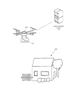
Referring now to FIG. 1, a system for monitoring premises according to some
embodiments
is shown. The system includes a central computer system 110 configured to
communicate with a
- 4 -
= CA 02952484 2016-12-21
UAV 120 including a sensor device 125 configured to obtain data from the
premises 130 which
may include one or more structures 132 and open areas 134. The central
computer system 110 may
comprise a control circuit, a central processing unit, a processor, a
microprocessor, and the like
and may be one or more of a server, a central computing system, a retail
computer system, a
personal computer system, and the like. Generally, the central computer system
110 may be any
processor-based device configured to communicate with UAVs and process 3D and
image data.
The central computer system 110 may include a processor configured to execute
computer
readable instructions stored on a computer readable storage memory. The
central computer system
110 may generally be configured to cause the UAV 120 to travel to monitored
premises 130 to
gather a set of data and compare the gathered data with a baseline condition
model associated with
the premises to detect potential security concerns. Generally, the central
computer system 110
may perform one or more steps in the methods and processes described with
reference to FIGS. 2
and 4 herein. Further details of a central computer system 110 according to
some embodiment is
provided with reference to FIG. 3 herein.
The UAV 120 may generally comprise an unmanned aerial vehicle configured to
carry a
sensor device 125 in flight and fly near the premises 130 for data capture. In
some embodiments,
the UAV 120 may comprise a multicopter configured to hover at and/or near the
monitored
premises 130. In some embodiments, the UAV may be a quadcopter, or hexacopter,
octocopter,
etc. In some embodiments, the UAV 120 may comprise a communication device
configured to
communicate with the central computer system 110 before and/or during flight,
a GPS receiver
configured to provide geolocation information of the UAV 120, and a control
circuit configured
to control the motors driving a plurality of propellers to navigate the UAV
120. In some
embodiments, the UAV 120 may include other flight sensors such as optical
sensors and radars for
detecting obstacles in the path of flight to avoid collisions. While only one
UAV 120 is shown, in
some embodiments, the central computer system 110 may communicate with and/or
provide
instructions to a plurality of UAVs. In some embodiments, two or more UAVs may
be deployed
to monitor the premises 130 at the same time and/or in shifts.
The sensor device 125 may comprise one or more sensors for capturing data at
the
monitored premises 130. The sensor device 125 may comprise one or more of a 3D
scanner, an
image sensor, a sound sensor, a light sensor, a visible spectrum camera, a
thermal image sensor, a
night vision camera, etc. In some embodiments, one or more sensors may be
coupled to an actuator
- 5 -
CA 02952484 2016-12-21
that pivots and/or rotates the sensor relative to the body of the UAV 120. The
sensor device 125
may be one or more devices attached to the UAV' s body through one or more
attachment means
and/or may be integrated with the body of the UAV 120. While the sensor device
125 unit is
shown to be attached to the bottom of the UAV 120 in FIG. 1, in some
embodiments, sensors may
be attached to different portions of the UAV (e.g. top, wing, landing gear,
etc.). In some
embodiments, the sensor device 125 may be a standalone device for recording
data that may
operate independently when detached from the UAV 120. In some embodiments, the
sensor device
125 may be at least partially integrated with the controls of the UAV 120. In
some embodiments,
the sensor device 125 and the UAV may share the same one or more of: a control
circuit, a memory
storage device, and a communication device. In some embodiments, the sensor
device 125 may be
communicatively coupled to the control circuit of the UAV 120 and configured
to receive
commands from the control circuit of the UAV 120 (e.g. began captured, end
captured, rotate,
etc.). In some embodiments, the sensor device 125 may comprise a communication
device for
independently communicating with the central computer system 110. Herein, a
UAV may refer to
a UAV 120 with or without a sensor device 125 attached to and/or integrated
with the UAV.
Further details of a UAV 120 according to some embodiments is provided with
reference to FIG.
3 herein.
The premises 130 may generally be any premises including buildings and/or open
areas. In
some embodiments, the monitored premises 130 may be real-estate owned, rented,
and/or managed
by a retail entity or customer. While single residence residential premises is
shown in FIG. 1, in
some embodiments, the premises may correspond to one or more of a multi-
residence residential
premises (e.g. condos, apartments, duplexes, multiplexes) and non-residential
premises (e.g. office
building, retail building, storage facility, distribution center, factory,
farm, ranch, etc. ). The
premises 130 may include one or more structures 132 such as a house, a shed, a
garage, a car port,
a patio, a gazebo, etc. that may be scanned from the exterior of the
structures. The premises 1 30
may further include one or more open areas 134 such as one or more of front
yard, back yard, side
yard, drive way, parking lot, road way, etc. The UAV 120 may capture data from
one or both of
structures and open areas at the premises and relay the captured data back to
the central computer
system 110. In some embodiments, the captured data may be transmitted
substantial real-time back
to the central computer system 110.
- 6 -
CA 02952484 2016-12-21
Referring now to FIG. 2, a method of monitoring premises is shown. In some
embodiments,
the steps shown in FIG. 2 may be performed by a processor-based device, such
as the central
computer system 110 shown in FIG. 1, the control circuit 314, the control
circuit 342, and/or the
control circuit 321 described with reference to FIG. 3 below. In some
embodiments, the steps may
be performed by one or more of a processor at the central computer system, a
processor of a user
device, a processor of a UAV, and a processor of a sensor device carried by
the UAV.
In step 220, the system instructs a UAV to perform a 3D scan at a monitored
premises. In
some embodiments, prior to step 220, a request to monitor the premises
location may be received
via a user interface device such as an in-store kiosk, a web-accessible user
interface, a customer
service counter, a mobile application, a computer program user interface, and
a store customer
service associate terminal, etc. The security monitoring request may include
premises location
information such as an address and/or a coordinate. In some embodiments, the
user interface may
display a map, a satellite view, and/or a street view to the user to confirm
the location and/or
boundary of the premises. In some embodiments, the systems may further be
configured to verify
that the user has the authority to request monitoring of the indicated
premises. For example, a user
interface device and/or a store associate may verify that the entered premises
information
corresponds to a residential or commercial property owned, rented, and/or
managed by the
customer by scanning one or more of the customer's goverment issued
identification (e.g. driver's
license, passport, etc.), the customer's bank card (e.g. credit card, debit
card, etc.), the customer's
utility bills, etc. In some embodiments, the system may also display
configurable access
permissions to a user and receive the user's selection of permissions. For
example, the system may
display one or more areas to monitor (e.g. front yard, back yard, house,
detached garage, store
shed, etc.), one or more types of data to gather (e.g. 3D model, colored
images, thermal images,
etc.), and one or more capture time frames (e.g. 2pm-5pm, weekdays only, etc.)
for user selection.
In some embodiments, some data types and/or areas may be mandatory for
enrolling in the security
monitoring program. In some embodiments, the customer may selectively
authorize the collection
of one or more types of data from one or more areas. In some embodiments, the
user may further
authorize and configure the schedule for repeated periodic monitoring (e.g.
hourly, daily. etc.)
and/or the duration of the monitoring service subscription (e.g. one weekend,
one month, etc.).
The system may instruct a UAV to travel to the premises location based on the
security
monitoring request and configuration. For example, a user may selectively
configure how often
- 7 -
CA 02952484 2016-12-21
=
the premises should be visited by a UAV (e.g. hourly, every three hours,
daily). In some
embodiments, a user may selectively enable and disable security monitoring
based on their
schedule. In some embodiments, the system may use the GPS location information
of a user device
to determine whether a user associated with the premises is at home, and only
have a UAV visit
the premises when the user is away from home. In some embodiments, a
monitoring trip may be
initiated on-demand by a user. For example, a user may use a web-based and/or
app-based user
interface to request the dispatch of a monitoring UAV. In some embodiment, the
UAV may
perform security monitoring of the premises during a package delivery trip.
For example, a IJAV
may collect security monitoring related data when it delivers an item to the
premises location that
had previously enrolled in the security monitoring program. In another
example, a delivery UAV
may perform security monitoring of premises locations that are near its route
to and from one or
more delivery destinations.
In some embodiments, the system may determine GPS coordinates of the monitored
premises based on the premises location information submitted with a
monitoring request. In some
embodiments, the system may use satellite image information to determine the
boundary of the
premises. In some embodiments, a central computer may further determine a
route for the UAV
to travel from a dispatch location to the monitored premises and communicate
the route to the
UAV. The route may be determined based on avoiding no-fly zones (e.g.
government regulation
flight restricted zones, tall buildings, power lines, etc.) on the path. In
some embodiments, the
central computer may maintain communication with the UAV to assist in the
navigation as the
UAV travels to the monitored premises. In some embodiments, the system may
further determine
a set of data to collect based on the monitoring request and/or a previously
established baseline
condition model and communicates information relating to data to be collected
to the UAV. In
some embodiments, the system may select a UAV from a plurality of UAVs based
on or more of
monitored premises location, UAV location, UAV condition (e.g. charge state,
range, scheduled
task, etc.), and premises type (e.g. single residence residential premises,
commercial premises,
etc.).
In some embodiments, the central computer system may maintain communication
with the
UAV as the UAV performs a 3D scan at the monitored premises. In some
embodiments, the central
computer may instruct the UAV to activate one or more sensors such as one or
more of a 31)
scanner, an image sensor, a sound sensor, a thermal sensor, etc. at one or
more locations and/or
- 8 -
= CA 02952484 2016-12-21
one or more orientations at the monitored premises. In some embodiments, the
UAV may be
preloaded with a set of instructions for gathering data and be configured to
determine where and
how to collect at least some data in the data set at the premises. In some
embodiments, the system
may determine where and how to capture data at the monitored premises based on
a previous
baseline survey of the premises. For example, the system may determine one or
more locations for
data capture based on a previous survey of the premises such that a desired
data set is gathered
with minimal scans and data capture time. In some embodiments, a UAV may hover
at one or
more locations such that the 3D scanner on the UAV may obtain scans from
different angels. In
some embodiments, the system may use data captured by the UAV to determine
additional data to
collect. For example, the system may determine additional locations and/or
angles to acquire the
desired data set. For example, if a feature relevant to security monitoring is
obstructed by
vegetation, the system may determine a different capture location to obtain an
image and/or 31) o
the relevant feature. In some embodiments, the central computer may instruct
the UAV to land to
collect one or more types of data in the data set. For example, a UAV may land
at a designated
location on the premises prior to beginning a 31) scan.
In some embodiments, the system may form a 3D point cloud model of the
premises based
on the 3D data collected by the 3D scanner of the UAV in step 220. In some
embodiments, the 3D
scanner on the UAV may comprise a large volume 3D laser scanner such as a Faro
Focus3D
scanner. In some embodiments, the scanner may be configured to measure
distances between the
scanner and a plurality of points in its surrounding area to obtain a 3D point
cloud of its
surrounding. The 3D scanner may include an actuator for pointing the laser at
different angles
around the scanner. In some embodiments, the distance measurement may be
obtained from
repeated measurements of reflected laser at different angles. In some
embodiments, the system
and/or the 3D scanner may stitch point clouds captured at different locations
to form a 31) point
cloud of the premises. The stitching may be based on the location of the 3D
scanner at the time o f'
the capture. In some embodiments, the location of the 3D scanner may be based
on a GPS and/or
cellular receiver associated with the 3D scanner. In some embodiments, the 3D
point cloud model
of the premises may correspond to a high precision (e.g. centimeter,
millimeter, or higher
resolution and accuracy) and at-scale virtual 3D model of the monitored
premises.
In some embodiments, the system may also be configured to determine areas
and/or
directions to avoid. For example, the UAV may be instructed to prevent sensors
from gathering
- 9 -
CA 02952484 2016-12-21
data from specified areas and/or directions such that data from neighboring
premises are not
collected. In some embodiments, the system may be configured to automatically
purge data
collected from neighboring premises. For example, the system may determine a
boundary of the
monitored premises and avoid collecting data from structures and views outside
of the monitored
premises.
In some embodiments, while a UAV is at monitored premises, a user associated
with the
premises may be given at least partial control of the UAV to manually direct
the monitoring of the
premises. For example, the system may notify a user when a UAV is on-premises
via a user
interface. The user may control the direction of a camera on the UAV and/or
select UVA hover
locations to monitor the premises via the user interface. The system may relay
the images and/or
sound captured by the UAV to the user via the user interface substantially in
real-time.
In step 240, the system compares a 3D point cloud model of the monitored
premises with
a baseline state model. The system may compare a current state of one or more
features in the 31)
point cloud of the monitored premises captured in step 220 with the baseline
state of the one or
more features of the monitored premises in the baseline state model. The
baseline state model may
be retrieved from a baseline state model database storing baseline state
models of one or more
monitored premises locations. A baseline state model generally provides
information on the
expected baseline state of the monitored premises. In some embodiments, the
baseline state model
may include a baseline 3D point cloud model end one or more of colored images,
thermal images,
and night-vision images of the monitored premise. In some embodiments, the
baseline state model
may identify one or more security related features of the monitored premises
and specify a baseline
state for each security related features. In some embodiments, the baseline
state model may further
include deviation thresholds for generating security alerts for one or more
features.
In some embodiments, the baseline state model may comprise and/or be based on
a 31)
point cloud of the monitored premises captured at an earlier time and/or
attributes derived from
such 3D point cloud. In some embodiments, the baseline state model may further
be determined
based on other types of data such as images captured at the premises,
customer's profile
information, customer inputted information, and premises
neighborhood/geographic information.
In some embodiments, when the system first receives a monitoring request, the
system may initiate
an initial survey of the premises to establish a baseline condition model for
the premises. The
- 10-
= CA 02952484 2016-12-21
initial survey may be performed by a ground and/or a UAV carried 3D scanner
configured to obtain
a 31) point cloud of the premises. In some embodiments, the initial survey may
also include data
collected by an image sensor such as a camera and/or a thermal sensor. In some
embodiments, the
system may analyze the 3D point cloud and/or captured images to identify one
or more features at
the monitored premises, determine a baseline state for one or more features,
and/or perform one
or more measurements. One or more of the 31) point cloud, the captured images,
the identified
features, the baseline states, and the measurements may be stored as part of
the baseline state
model. In some embodiments, the system may instruct the owner/occupier/manager
to prepare the
premises for the initial security survey. For example, the system may instruct
that all windows and
doors of the premises be closed and all security lights and cameras be turned
on prior to the initial
security survey. In some embodiments, the system may instruct one or more UAVs
to perform one
or more initial surveys to establish the baseline condition of the premises.
In some embodiments,
the initial survey includes data captured by other types of sensors such as a
colored image sensor,
a thermal sensor, night vision cameras, etc. The system may be configured to
identify one or more
features and determine one or more baseline and current states based further
on colored images
and/or thermal images captured at the monitored premises. In some embodiments,
the system may
be configured to generate security improvement recommendations based on
analyzing the initial
security survey. For example, the system may recommend the installation of
lights and/or fencing
based on the initial security survey.
In some embodiments, the baseline state 3D point cloud of the premises
location may be
directly compared with the 31) point cloud captured in step 220 to detect
differences between the
31) point cloud models. In some embodiments, the system may identify one or
more features in
the 3D point cloud captured in step 220 and compare the states of the
identified features with the
baseline states of the corresponding features in the baseline state model.
In some embodiments, the system may be configured to identify one or more of a
door, a
gate, a window, an electrical box, a security camera, a light fixture, a door
hinge, a door knob, a
window panel, patio furniture, etc. based on the 3D point cloud and/or other
captured data such as
colored images and thermal images. Features may be identified based on one or
both of data
captured during the baseline survey and during a subsequent monitoring trip.
The one or more
features may be identified using object recognition algorithms and may be
based on one or more
of the object's color, shape, dimension, location, temperature, and
identifying marking. In some
-11-
= CA 02952484 2016-12-21
embodiments, one or more features may be identified based on an active signal
transmitter and/or
a passive radio frequency identity (RFID) tag. In some embodiments, the system
may compare
portions of the 3D model and image data with a database of known features. The
database of
known features may comprise characteristics of objects including one or more
of color, shape,
dimension, likely location, likely temperature, identifying marking, 2D image,
and 3D model
associated with the feature. In some embodiments, the system may be configured
to identify one
or more of a wall, a yard, a gate, a door, a window, a planter, a roof
section, a gutter, a pillar, a
beam, a fence, a furniture, a security device, vegetation, and the like.
Generally, a feature may be
any identifiable object and/or structural element. In some embodiments, the
features may further
include environmental conditions such as shadows, shades, puddles, snow
accumulations, etc. In
some embodiments, the system may allow for manual correction of the identified
objects either by
associates and/or customers associated with the monitored premises.
In some embodiments, a baseline or current state of a feature may correspond
to one or
more of a location, a presence, an appearance, an orientation, etc. of a
feature. In some
embodiments, the system may determine a state of one or more features in the
captured 3D point
cloud and compare the identified feature and state with the corresponding
feature in the baseline
model location. By comparing the current state of a feature with a baseline
state, the system may
identify security concerns by detecting the differences in the state of the
feature. For example, with
the comparison, the system may identify whether any door hinges or window
panels has been
removed or damaged. In another example, the system may identify whether the
direction of a
security camera has been altered. In some embodiments, the state of a feature
may corresponds to
measurements taken based on the 3D point cloud model. For example, the system
my measure one
or more of a gap width between a door and a door frame, a gap width between
door panels, a gap
width between a window and a window frame, and a gap width between window
panels. The
baseline model may specify a baseline state gap width between a door and a
door frame, and the
system may measure the current gap width of the door and the door frame in the
capture 3D point
cloud model and compare the measurement with the baseline state gap width. In
some
embodiments, the system may compare a captured thermal map with a baseline
state thermal map
of the premises to determine whether a human is present at the premises and/or
whether a heater,
an air conditioning unit, an oven, and/or a stove has been left on.
- 12-
= = CA 02952484 2016-12-21
In some embodiments, the system may determine what to look for in the captured
31) point
cloud model and/or images based on the baseline state model. In some
embodiments, the baseline
state model may provide locations and/or identifying characteristics of
security related features at
particular premises, and the system may use that information to isolate one or
more features in the
captured 3D point cloud and/or images for analysis. For example, the baseline
state model may
identify the locations of glass window panels, security cameras, locks, etc.,
and corresponding
locations in captured 3D point cloud may be analyzed for the state of a
feature matching the shape,
color, location, etc. of the expected feature. In another example, the
baseline state model may
specify the locations and the expected width of one or more door or window
gaps, and the system
may measure the width of gaps at the corresponding locations in the captured
3D point cloud to
determine a current state of the feature.
In some embodiments, the UAV may communicate with stationary security devices
at the
premises to monitor the premises. In some embodiments, the UAV further
comprises a short-range
wireless communication device configured to communicate with one or more
stationary devices
on the monitored premises. The one or more stationary devices may comprise one
or more of a
door sensor, a window sensor, a motion sensor, a security camera, a gas
sensor, and an appliance.
The UAV may ping and/or wakeup one or more of the stationary devices to
receive a data reading
from each of the connected devices. The baseline model may further include
baseline states for the
one or more devices. The system may further compare data received from the
stationary device(s)
with the baseline state to determine deviations from the baseline state and/or
generate security
alerts. For example, the short range transceiver of the UAV may detect that
one or more of a door
sensor, a window sensor, a motion sensor, a security camera, a gas sensor, and
an appliance that
should be on is offline and/or turned off. The status of the stationary
devices may be report to the
central computer system and/or the user.
In step 250, the system identifies a deviation in the current state of one or
more features of
the monitored premises from the baseline state. In some embodiments, with the
comparison in step
204, the system may identify misplaced, missing, and/or, altered features,
and/or unexpected
objects. In some embodiments, the system may determine that an object's
orientation and/or a gap
between two objects deviates from the baseline state. Generally, the system
may detect deviations
of the current state of one or more features from a baseline state specified
in the baseline model.
- 13-
= CA 02952484 2016-12-21
In some embodiments, after a deviation is detected, the system may determine
whether the
deviation is relevant to security concerns and/or exceeds a threshold for
generating an alert. For
example, the system may be configured to ignore any deviations in the size and
shape of vegetation
around the house and/or movements of objects resembling a household pets. In
some embodiments,
the system may determine whether deviation in the door or window gap may be
attributed to
temperature changes or exceeds a threshold indicating that intentional
tempering has likely
occurred. In some embodiments, if the deviation is determine to be relevant to
security concerns
and/or exceeds a threshold deviation value, a system may generate a security
alert to a user
associated with the premises. The security alert may be provided to a user via
a text message, an
email message, a phone call, a mobile application, a web-accessible user
interface, and the like. In
some embodiments, the system may further be configured to alert a security
personnel to
investigate the deviation.
In some embodiments, after receiving a security alert, the user may use a user
interface to
indicate that the security alert should be investigated or ignored. For
example, the system may
generate an alert when a door to a shed is left open, and the user may
indicate that the state of the
door to the shed should be ignored as it is often left open by the owner of
the house. The system
may be configured to update the baseline state model based on user feedback.
In another example,
the system may generate an alert for a broken window, and the user may
indicate that they do not
intend to fix the window immediately and the system should ignore that window
for a set period
of time. In yet another example, the system may generate an alert when an
unknown car is parked
on the driveway. The user may indicate that the car is new to the household
via the user interface
and no further alerts should be generated for that car. Generally, user
feedback may be used to
determine the types of features and deviations to detect and/or ignore and/or
determine the
deviation threshold for generating a security alert. The system may be
configured to update the
baseline model accordingly.
In some embodiments, the system may generates a security recommendation based
on the
data collection performed in step 220 and/or an initial security survey. For
example, the system
may detect a dark corner that may be of security concern to the home owner,
and recommend the
installation of an additional outdoor light and/or camera at the location.
- 14 -
= = CA 02952484 2016-12-21
Referring now to FIG. 3, a block diagram of a system for monitoring premises
is shown.
The system includes a central computer 310, a UAV 320, a baseline state model
database 330, and
a user interface device 340.
The user interface device 340 comprises a control circuit 342 and a memory
343. The user
interface device 340 may be one or more of a kiosk, an in-store terminal, a
computer accessing a
website, a computer running a program, a mobile device running a mobile
application, etc. The
control circuit 342 may be configured to execute computer readable
instructions stored on a
memory 343. The computer readable storage memory 343 may comprise volatile
and/or non-
volatile memory and have stored upon it a set of computer readable
instructions which, when
executed by the control circuit 342, causes the control circuit 342 to provide
an user interface to a
user and exchange information with the central computer 310 via the user
interface. The user
interface device 340 may further comprise one or more user input/output
devices such as a touch
screen, a display, a keyboard, etc. that allows a user to enter premises
location and/or
authentication information. The user interface device 340 may further allow
the user to receive
and view alerts generated by the central computer 310 and/or partially control
UAV(s) monitoring
premises associated with the user. In some embodiments, the user interface
device 340 may be
owned and/or operated by a customer and/or a retail entity. The user interface
device 340 may
further include a network interface for communicating with the central
computer 310 via a network
such as the Internet and/or a store's private network. In some embodiments,
the user interface
device 340 may further include a scanner and/or reader for scanning an image,
an optical code, a
magnetic trip, an integrated circuit (IC) chip, and/or a RFID tag on one or
more of the customer's
government issued identification (e.g. driver's license, passport, etc.), the
customer's bank card
(e.g. credit card, debit card, etc.), and the customer's utility bills for
identity verification.
The central computer 310 comprises a communication device 312, a control
circuit 314,
and a memory 316. The central computer 310 may be one or more of a server, a
central computing
system, a retail computer system, and the like. In some embodiments, the
central computer 310
may be the central computer system 110 in FIG. 1. In some embodiments, the
central computer
310 may comprise a system of two or more processor-based devices. The control
circuit 314 may
comprise a processor, a microprocessor, and the like and may be configured to
execute computer
readable instructions stored on a computer readable storage memory 316, The
computer readable
storage memory 316 may comprise volatile and/or non-volatile memory and have
stored upon it a
- 15-
= CA 02952484 2016-12-21
set of computer readable instructions which, when executed by the control
circuit 314, cause the
system to instruct the UAV to travel to monitored premises to gather data, and
compare the
collected data to a baseline state model in the baseline state model database
330 to detect deviations
from the baseline state model. Generally, the computer executable instructions
may cause the
control circuit 314 of the central computer 310 to perform one or more steps
in the methods and
processes described with reference to FIGS. 2 and 4 herein.
The central computer 310 may be coupled to a baseline state model database 330
via a
wired and/or wireless communication channel. In some embodiments, the baseline
state model
database 330 may be at least partially implemented with the memory 316 of the
central computer
310. The baseline state model database 330 may have stored upon it a plurality
of 31) models
and/or feature baseline states of one or more monitored premises. Each
baseline state model may
comprise one or more of a 3D point cloud, areas and/or features to monitor,
measurements of
features, alert thresholds, etc. of the monitored premises. In some
embodiments, the baseline state
model may further include image sensor data such as visible and invisible
(e.g. infrared, ultraviolet,
thermal, night-vision, etc.) wavelength images. In some embodiments, the
baseline state model
may further include data associated stationary devices such one or more of a
door sensor, a window
sensor, a motion sensor, a security camera, a gas sensor, an appliance, etc.
In some embodiments, the baseline state models may be built based on an
initial survey o
the monitored premises. In some embodiments, the central computer 310 may be
configured to
update the baseline state model of a monitored premises location based on
subsequent scans and/or
user feedback. For example, if a new security camera is installed, the system
may update the
baseline model to include the location and/or orientation of the new security
camera.
The UAV 320 may comprise an unmanned aerial vehicle configured to carry
sensors and
fly near monitored premises for data capture. In some embodiments, the UAV 320
may comprise
a multicopter configured to hover at or near the monitored premises. For
example, the UAV may
be a quadcopter, or hexacopter, octocopter, etc. In some embodiments, the UAV
320 may be the
UAV 120 in FIG. 1. The UAV 320 includes a control circuit 321, motors 322, a
UPS sensor 323,
a long range transceiver 325, a short range transceiver 326, a 3D scanner 327,
and an image sensor
328.
- 16-
= = CA 02952484 2016-12-21
The control circuit 321 may comprise one or more of a processor, a
microprocessor, a
microcontroller, and the like. The control circuit 321 may be communicatively
coupled to one or
more of the motors 322, the GPS sensor 323, the long range transceiver 325,
the short range
transceiver 326, the 3D scanner 327, and the image sensor 328. Generally, the
control circuit 321
may be configured to navigate the UAV 320 based on instructions received form
the central
computer 310 and cause the sensors to gather a set of data at the monitored
premises. In some
embodiments, the UAV 320 may include separate control circuits for controlling
the navigation of
the UAV 320 and operating at least some of the sensor devices carried by the
UAV 320.
The motors 322 may be motors that control one or more of a speed and/or
orientation of
one or more propellers on the UAV 320. The motors 322 are configured to be
controlled by the
control circuit 321 to lift and steer the UAV 320 in designated directions.
The GPS sensor 323
may be configured to provide a GPS coordinate to the control circuit 321 for
navigation. In some
embodiments, the UAV 320 may further include an altimeter for providing
altitude information to
the control circuit 321 for navigation. Generally, the UAV may use the GPS and
the altimeter
readings to stay on a predetermined route to and from a monitored premises. In
some embodiments,
the UAV may further include short-range navigation sensors for avoiding
collisions with obstacles
in the path of the travel.
The long range transceiver 325 may comprises one or more of a mobile data
network
transceiver, a satellite network transceiver, a WiMax transceiver, and the
like. Generally, the long
range transceiver 325 is configured to allow the control circuit 321 to
communicate with the central
computer 310 while the UAV 320 is in flight and/or at monitored premises. In
some embodiments,
the central computer 310 maintains communication with the UAV 320 as the UAV
320 travels to
the monitored premises and collect data.
The short range transceiver 326 may comprise one or more of a Wi-Fi
transceiver, a
Bluctooth transceiver, a RFID reader, and the like. Generally, the short range
transceiver 326 has
a range of several feet and is configured to allow the control circuit 321 to
communicate with one
or more on-premises devices at the monitored premises. The monitored premises
may include one
or more stationary devices such a door sensor, a window sensor, a motion
sensor, a security
camera, a gas sensor, and an appliance. In some embodiments, the one or more
on-premises
devices may be initially placed by a UAV, a service personnel, and/or a
service subscriber. The
- 17-
= CA 02952484 2016-12-21
control circuit 321 may retrieve data from the stationary devices via the
short range transceiver
326. In some embodiments, the collected data may comprise a history of data
recorded over time.
In some embodiments, the control circuit 321 may be configured to activate a
stationary device to
begin data collection/transmission via the short range transceiver 326. In
some embodiments, the
stationary devices may communicate directly with the central computer 310 via
the internet.
The 3D scanner 327 generally comprises a scanner configured to generate a 3D
point cloud
of at least part of its surroundings. The 3D scanner 327 may comprise a large
volume 3D laser
scanner such as a Faro Focus3D scanner. In some embodiments, the 3D scanner
327 may be
configured to measure the distance between the scanner and a plurality of
points in its surrounding
to obtain a 3D point cloud of its surroundings. The 3D scanner 327 may include
an actuator for
pointing the laser at different angles around the scanner. In some
embodiments, the distance
measurement may be obtained from repeated measurements of reflected laser at
different angles.
In some embodiments, the central computer 310 and/or the 3D scanner 327 may
stitch point clouds
captured at different locations and/or perspectives to form a 31) point cloud
of the premises.
The image sensor 328 may comprise visible and/or invisible light spectrum
image sensors.
In some embodiments, the image sensor 328 may comprise a 2D image sensor such
as a colored
image camera and/or a thermal image sensor. In some embodiments, the image
sensor 328 may
capture images from the same perspectives as the 3D scanner to correlate the
distance
measurements made by the 3D scanner with the image information captured by the
image sensor
328.
While only one UAV 320 is shown, in some embodiments, the central computer 310
may
communicate with and/or control a plurality of UAVs. In some embodiments, two
or more UAVs
may be deployed to monitor the premises location at the same time. For
example, two or more
UAVs may perform 3D scans of the same premises from different angels and
locations. In some
embodiments, two or more UAVs may monitor one or more premises in shifts. In
some
embodiments, the UAV 320 and/or a similar UAV may be dispatched to perform an
initial survey
of the premises to establish a baseline condition model of the monitored
premises.
In some embodiments, one or more of the short range transceiver 326 and the
image sensor
328 may be optional to at least some UAVs in the system. In some embodiments,
one or more or
the 31) scanner 327 and the image sensor 328 may be part of a sensor device
controlled by a
- 18-
CA 02952484 2016-12-21
separate control circuit. The sensor device may communicate with the control
circuit 321 via a
local connection and/or the central computer 310 via the long range
transceiver 325 and/or a
separate transceiver. In some embodiments, the data collected by one or more
of the 3D scanner
327 and the image sensor 328 may be communicated back to the central computer
310 substantially
in real-time. The central computer 310 may use the collected data to determine
further instructions
for the UAV 320 at the monitored premises. In some embodiments, the data
collected by one or
more of the 3D scanner 327 and the image sensor 328 may be stored on a memory
device on the
UAV 320 and transferred to the central computer 310 at a later time.
In some embodiments, the UAV 320 may further include other flight sensors such
as
optical sensors and radars for detecting obstacles in the path of flight. In
some embodiments, one
or more of the 3D scanner 327 and the image sensor 328 may also be used as
navigation sensors.
Referring now to FIG. 4, a process for monitoring premises according to some
embodiments is shown. In step 411, a customer provides initial information via
a customer
interface application. While a customer interface application is shown in FIG.
4, the user interface
may generally be provided via one or more of a web-accessible interface, a
mobile application, a
computer program, and the like. The initial information may include premises
location, monitoring
schedule, monitoring options, user authentication information, etc. In step
421, a satellite image of
a requested premises is obtained. In step 431, the central computer determines
surveillance
boundary and parameters of the premises. The surveillance boundary and
parameters may be based
on the information entered in step 411 and other premises information such as
property record,
satellite image obtained in step 421, zoning restrictions, etc.
In step 432, UAVs are dispatched to the monitored premises. In step 441, the
UAVs fly
over and through the property, perform a 3D scan, and collect images and data
from the monitored
premises. In some embodiments, one or more UAVs may perform step 432 at a
time. In step 435,
measurements, videos, and 3D scan data are recorded at the central computer.
In step 414, the
captured data and images may be made available for playback to the user via
the user interface. In
step 434, the central computer creates a map and/or model of the monitored
premises based on the
collected data. In step 413, the maps and models may be made available for
viewing by the user
via the user interface.
- 19-
= CA 02952484 2016-12-21
In step 433, the system performs analyze and assessment of security elements
based on the
collected data. In some embodiments, the analysis may be based on comparing
the collected data
with a baseline state model of the premises. In step 412, the alert(s)
generated based on the analysis
in step 433 may be made available to users via the customer interface
application. After step 433,
the process may return to step 432 for a subsequent security monitoring UAV
dispatch.
In one embodiment, a system for monitoring premises comprises: an unmanned
aerial
vehicle (UAV) comprising a three dimension (3D) scanner, a baseline model
database, and a
control circuit comprising a communication device for communicating with the
UAV. The control
circuit being configured to: instruct the UAV to travel to monitored premises
and perform a 31)
scan with the 3D scanner to obtain a 3D point cloud of the monitored premises,
retrieve a baseline
state model of the monitored premises from the baseline model database, the
baseline state model
comprises a baseline state of one or more features of the monitored premises,
compare a current
state of the one or more features in the 3D point cloud of the monitored
premises with the baseline
state of the one or more features in the baseline state model, and identify a
deviation of the current
state of the one or more features of the monitored premises from the baseline
state.
In one embodiment, a method for monitoring premises comprises: instructing,
with a
control circuit, an unmanned aerial vehicle (UAV) comprising a three dimension
(3D) scanner to
travel to monitored premises and perform a 3D scan with the 3D scanner to
obtain a 3D point cloud
of the monitored premises, retrieving a baseline state model of the monitored
premises from a
baseline model database, the baseline state model comprises a baseline state
of one or more
features of the monitored premises, comparing, with the control circuit, a
current state of the one
or more features in the 3D point cloud of the monitored premises with the
baseline state of the one
or more features in the baseline state model, and identifying a deviation of
the current state of the
one or more features of the monitored premises from the baseline state.
In one embodiment, an apparatus for monitoring premises comprises a non-
transitory
storage medium storing a set of computer readable instructions and a control
circuit configured to
execute the set of computer readable instructions which causes to the control
circuit to: instruct an
unmanned aerial vehicle (UAV) comprising a three dimension (3D) scanner to
travel to monitored
premises and perform a 3D scan with the 3D scanner to obtain a 3D point cloud
of the monitored
premises, retrieve a baseline state model of the monitored premises from a
baseline model
- 20 -
CA 02952484 2016-12-21
database, the baseline state model comprises a baseline state of one or more
features o the
monitored premises, compare, with the control circuit, a current state of the
one or more features
in the 31) point cloud of the monitored premises with the baseline state of
the one or more features
in the baseline state model, and identify a deviation of the current state of
the one or more features
of the monitored premises from the baseline state.
Those skilled in the art will recognize that a wide variety of other
modifications, alterations,
and combinations can also be made with respect to the above described
embodiments without
departing from the scope of the invention, and that such modifications,
alterations, and
combinations are to be viewed as being within the ambit of the inventive
concept.
-21 -