Note: Descriptions are shown in the official language in which they were submitted.
81800452
MAGNETIC RANGING TO AN AC SOURCE WHILE ROTATING
CROSS-REFERENCE TO RELATED APPLICATION
[0001] The present application claims priority from U.S. Non-Provisional
Patent
Application 14/318372, filed June 27, 2014.
FIELD OF THE DISCLOSURE
[0002] Disclosed embodiments relate generally to magnetic ranging methods and
more
particularly to methods for magnetic ranging while drilling (i.e., while the
drill string is
rotating).
BACKGROUND INFORMATION
[0003] In subterranean drilling operations the need frequently arises to
determine the
relative location of the wellbore being drilled (the drilling well) with
respect to a pre-
existing offset wellbore (a target well). This need may exist for the purpose
of avoiding a
collision or making an interception, or for the purpose of maintaining a
specified
separation distance between the wells (e.g., as in well twinning operations
such as steam
assisted gravity drainage operations). Magnetic ranging techniques are
commonly
employed to determine the relative location of the target well, for example,
by making
magnetic field measurements in the drilling well. The measured magnetic field
may be
induced in part by ferromagnetic material or an electromagnetic source (or
sources) in the
target well such that the measured magnetic field vector may enable the
relative location
of the target well to be computed.
1
Date Recue/Date Received 2021-10-01
CA 02953513 2016-12-22
WO 2015/200751
PCT/1J52015/037884
[0004] Existing magnetic ranging techniques are similar to conventional static
surveys
in that they require drilling to be halted and the drill string to be held
stationary in the
drilling well while each magnetic survey is obtained. Magnetic ranging
operations arc
therefore costly and time consuming. Moreover, magnetic ranging is similar to
wellbore
navigation in that the well path may be continuously adjusted in response to
the ranging
measurements. It may therefore be desirable to make ranging measurements as
close to
the bit as possible, in order to gain the earliest possible notification of
required course
adjustments. Owing to the rotation of the bit, measurements made close to the
bit while
drilling are made from a rotating platform (i.e., with rotating magnetic field
sensors).
There is a need in the art for magnetic ranging methods that employ magnetic
field
measurements made from a rotating platform (rotating sensors).
SUMMARY
[0005] A method for magnetic ranging is disclosed. A downhole drilling tool is
rotated
in a drilling well in sensory range of magnetic flux emanating from a target
well having
an AC magnetic source deployed therein. The downhole tool includes a magnetic
field
sensor deployed therein. The magnetic field sensor measures a magnetic field
vector
while rotating. The measured magnetic field vector is processed to compute at
least one
of a distance and a direction from a drilling well to a target well.
100061 The disclosed methods may enable magnetic ranging measurements to be
acquired and processed while rotating the magnetic field sensors in the
drilling well. The
measurements may therefore be acquired and processed while drilling. Moreover,
in
embodiments in which the magnetic field sensors are mounted in a near-bit
sensor sub
2
81800452
below a mud motor, the ranging measurements may be acquired and processed
while
maintaining drilling fluid circulation.
[0007] This
summary is provided to introduce a selection of concepts that are further
described below in the detailed description. This summary is not intended to
identify key
or essential features of the claimed subject matter, nor is it intended to be
used as an aid in
limiting the scope of the claimed subject matter.
[0007a] Another aspect of the present disclosure relates to a method for
magnetic
ranging comprising: (a) rotating a downhole drilling tool in a drilling well
in sensory range
of magnetic flux emanating from a target well having an AC magnetic source
deployed
therein, the downhole drilling tool including a magnetic field sensor
rotatably coupled to
the downhole drilling tool; (b) causing the magnetic field sensor to measure a
magnetic
field vector while rotating in (a); (c) processing the magnetic field vector
measured in (b)
to compute a magnetic quantity including an amplitude of a transverse
component of the
magnetic flux emanating from the target well and an angle between the
transverse
component of the magnetic flux emanating from the target well and a transverse
component of Earth's magnetic field; and (d) processing the magnetic quantity
computed
in (c) to compute at least one of a distance and a direction from the drilling
well to the
target well.
10007b] Another aspect of the present disclosure relates to a method for
magnetic
ranging comprising: (a) rotating a downhole drilling tool in a drilling well
in sensory range
of magnetic flux emanating from a target well having an AC magnetic source
deployed
therein, the downhole drilling tool including a magnetic field sensor
rotatably coupled to
the downhole drilling tool; (b) causing magnetic field sensor to measure a
magnetic field
vector while rotating in (a); (c) processing the magnetic field vector
measured in (b) to
compute a difference between an instantaneous rotation rate and an average
rotation rate of
the downhole drilling tool; and (d) processing the difference computed in (c)
to compute a
direction from the drilling well to the target well.
[0007c] Another aspect of the present disclosure relates to a method for
magnetic
ranging comprising: (a) rotating a downhole drilling tool in a drilling well
in sensory range
of magnetic flux emanating from a target well having an AC magnetic source
deployed
therein, the downhole drilling tool including a magnetic field sensor
rotatably coupled to
the downhole drilling tool; (b) causing the magnetic field sensor to measure a
magnetic
3
Date Re9ue/Date Received 2021-10-01
81800452
field vector while rotating in (a); and (c) processing the magnetic field
vector measured in
(b) to compute at least one of a distance and a direction from a drilling well
to a target
well, wherein the processing in (c) comprises (i) processing the magnetic
field vector
measured in (b) to compute an amplitude of a transverse component of the
magnetic field
vector and (ii) processing the amplitude to compute the distance from the
drilling well to
the target well, and wherein the amplitude of the transverse component of the
magnetic
field vector is computed in (i) using at least one of the following
mathematical equations:
B B __ 2 + peo 2 \
xY x " Y
B,='2- cy(B ). )
x
wherein Bxy represents the amplitude of the transverse component of the
magnetic field
vector, Bx and By represent the transverse component of the magnetic field
vector
measured in (b), and o(Bx) and o(By) represent standard deviations of
corresponding sets
of Bx and By measurements.
[0007d] Another aspect of the present disclosure relates to a method for
magnetic
ranging comprising: (a) deploying a magnetic field sensor in sensory range of
magnetic
flux emanating from a ferromagnetic casing string having an AC magnetic source
deployed therein; (b) causing the magnetic field sensor to measure an AC
magnetic field
emanating from the casing string; (c) processing the magnetic field measured
in (b) to
compute an amplitude of at least one higher order harmonic; and (d) energizing
the AC
magnetic source with a non-sinusoidal input electrical current to reduce the
amplitude of
the higher order harmonic.
BRIEF DESCRIPTION OF THE DRAWINGS
[0008] For a more complete understanding of the disclosed subject matter,
and
advantages thereof, reference is now made to the following descriptions taken
in
conjunction with the accompanying drawings, in which:
[0009] FIG. 1 depicts one example of a conventional drilling rig on which
disclosed
methods may be utilized.
3a
Date Re9ue/Date Received 2021-10-01
81800452
[0010] FIG. 2 depicts a lower BHA portion of the drill string shown on
FIG. 1.
[0011] FIG. 3 depicts a flow chart of one disclosed method embodiment.
[0012] FIG. 4 depicts a schematic of the measured magnetic field in the
transverse
plane.
[0013] FIG. 5 depicts a plot of the transverse magnetometer outputs Bõ
and By as a
function of time.
[0014] FIG. 6 depicts an example plot of the radial Br and axial Bz
magnetic fields as a
function of measured depth for an example target well including a
premagnetized casing
string.
[0015] FIG. 7 depicts one example of a plot of the high side BHS versus
right side BRS
magnetic field components.
3b
Date Re9ue/Date Received 2021-10-01
CA 02953513 2016-12-22
WO 2015/200751
PCMJS2015/037884
[0016] FIG. 8 depicts a plot of radial 13r and axial B, magnetic fields verses
axial
position along the axis of target well having a residual remanent magnetism.
[0017] FIG. 9 depicts a flow chart of another disclosed method embodiment.
[0018] FIG. 10 depicts a schematic of the measured magnetic field including
the
Earth's field and target field in the transverse plane.
[0019] FIG. 11 depicts a flow chart of yet another disclosed method
embodiment.
DETAILED DESCRIPTION
[0020] FIG. 1 depicts a drilling rig 20 suitable for using various method
embodiments
disclosed herein. The rig may be positioned over an oil or gas formation (not
shown)
disposed below the surface of the Earth 25. The rig 20 may include a derrick
and a
hoisting apparatus for raising and lowering a drill string 30, which, as
shown, extends into
wellbore 40 and includes a drill bit 32 and a near-bit sensor sub 50 (such as
the iPZIGA,
tool available from PathFinderk, A Schlumberger Company, Katy, Texas, USA).
Drill
string 30 may further include a downhole drilling motor, a steering tool such
as a rotary
steerable tool, a downhole telemetry system, and one or more MWD or LWD tools
including various sensors for sensing downhole characteristics of the borehole
and the
surrounding formation. The disclosed embodiments are not limited in these
regards.
[0021] FIG. 1 further depicts a well twinning operation, such as a steam
assisted gravity
drainage (SAGD) operation, in which various disclosed method embodiments may
be
utilized. In common SAGD well twinning operations a horizontal twin well 40 is
drilled
a substantially fixed distance above a horizontal portion of a target wellbore
80 (e.g., not
deviating more than about 1 meter up or down or to the left or right of the
target). In the
depicted embodiment the target well 80 is drilled first, for example, using
conventional
4
CA 02953513 2016-12-22
WO 2015/200751
PCMJS2015/037884
directional drilling and MWD techniques. The target wellbore 80 may be
magnetized, for
example, via installing a plurality of premagnetized tubulars 85 in the
wellbore or
deploying a magnetic source 88 such as a DC or an AC electromagnet in the
wellbore.
Magnetic field measurements made while the drill string 30 rotates in the
drilling well 40
(e.g., at sensor sub 50) may then be used to determine a relative distance and
direction
from the drilling well 40 to the target well 30 (as described in more detail
below).
[0022] It will be understood by those of ordinary skill in the art that the
deployment
illustrated on FIG. 1 is merely an example. For example, while FIG. 1 depicts
a SAGD
operation, the disclosed embodiments are in no way limited to SAGD or other
well
twinning operations, but may be used in substantially any drilling operation
in which it is
desirable to determine the relative location of the drilling well with respect
to an offset
well. Such operations may be performed onshore (as depicted) or offshore.
[0023] FIG. 2 depicts the lower BHA portion of drill string 30 including drill
bit 32 and
near-bit sensor sub 50. In the depicted embodiment, sensor sub body 52 is
threadably
connected with the drill bit 32 and therefore configured to rotate with the
bit 32. The
depicted sensor sub 50 includes a tri-axial (three axis) accelerometer set 55
and a tri-axial
magnetometer set 57. In the depicted embodiment, the sensors 55 and 57 being
deployed
in a near-bit sensor sub may be deployed close to the drill bit 32, for
example, within two
meters, or even within one meter of the bit 32. However, it will be understood
that the
disclosed embodiments are not limited to the use of a near-bit sensor sub or
to the
deployment of the sensor close to the bit. Substantially any suitable
measurement tool
(such as a conventional MWD tool) including a magnetic field sensor may be
utilized.
100241 Suitable accelerometers and magnetometers for use in sensors 55 and 57
may be
chosen from among any suitable commercially available devices known in the
art. For
CA 02953513 2016-12-22
WO 2015/200751
PCMJS2015/037884
example, suitable accelerometers may include Part Number 979-0273-001
commercially
available from Honeywell, and Part Number JA-5H175-1 commercially available
from
Japan Aviation Electronics Industry, Ltd. (JAE). Other suitable accelerometers
may
include micro-electro-mechanical systems (MEMS) solid-state accelerometers,
available,
for example, from Analog Devices, Inc. (Norwood, Massachusetts). Such MEMS
accelerometers may be advantageous for certain near bit sensor sub
applications since
they tend to be shock resistant, high-temperature rated, and inexpensive.
Suitable
magnetic field sensors may include conventional ring core flux gate
magnetometers or
conventional magnetoresistive sensors, for example, Part Number HMC-1021D,
available
from Honeywell.
100251 FIG. 2 further includes a diagrammatic representation of the tri-axial
accelerometer and tri-axial magnetometer sensor sets 55 and 67. By tri-axial
it is meant
that each sensor set includes three mutually perpendicular sensors, the
accelerometers
being designated as 11,, Ay, and A, and the magnetometers being designated as
Bx, By,
and B. By convention, a right handed system is designated in which the z-axis
accelerometer and magnetometer (A, and B,) are oriented substantially parallel
with the
borehole as indicated (although disclosed embodiments are not limited by such
conventions). Each of the accelerometer and magnetometer sets may therefore be
considered as determining a transverse cross-axial plane (the x and y-axes)
and an axial
pole (the z-axis along the axis of the BHA).
100261 By further convention, the gravitational field is taken to be positive
pointing
downward (i.e., toward the center of the Earth) while the magnetic field is
taken to be
positive pointing towards magnetic north. Moreover, also by convention, the y-
axis is
taken to be the toolface reference axis (i.e., gravity toolface T equals zero
when the y-axis
6
CA 02953513 2016-12-22
WO 2015/200751
PCMJS2015/037884
is uppermost and magnetic toolface M equals zero when the y-axis is pointing
towards the
projection of magnetic north in the transverse (xy) plane). Those of ordinary
skill in the
art will readily appreciate that the magnetic toolface M is projected in the
xy plane and
may be represented mathematically as: tanM = Bx/By. Likewise, the gravity
toolface T
may be represented mathematically as: tanT = ¨Ax 1 ¨Ay. Those of skill in the
art will
understand that the negative sign in the gravity toolface expression arises
owing to the
convention that the gravity vector is positive in the downward direction while
the toolface
reference direction is the high side of the borehole (the side facing upward).
[0027] It will be understood that the disclosed embodiments are not limited to
the above
described conventions for defining the borehole coordinate system. It will be
further
understood that these conventions can affect the form of certain of the
mathematical
equations that follow in this disclosure. Those of ordinary skill in the art
will be readily
able to utilize other conventions and derive equivalent mathematical
equations.
[0028] FIG. 3 depicts a flow chart of one disclosed method embodiment 100. A
sensor
sub (e.g., sub 50) including accelerometers and magnetometers is rotated in a
drilling well
at 102 in sensory range of magnetic flux emanating from a target wellbore.
Accelerometer and magnetometer measurements are acquired at 104 while rotating
in
102. The acquired transverse magnetometer measurements may be transformed at
106 to
a reference frame that is independent of the sensor rotation in 102. The
transformed
measurements may then be processed at 108 to compute at least one of a
distance and a
direction from the drilling well to the target well.
100291 During rotation at 102, the transverse sensor (accelerometers A, and Ay
and
magnetometers Bx and By) measurements may be expressed mathematically, for
example,
as follows:
7
CA 02953513 2016-12-22
WO 2015/200751
PCMJS2015/037884
= ¨11õ3, = sin T (1)
Ay = ¨Axy = cosT (2)
B, = ky = sin M (3)
By = 13,3, = cos M (4)
[0030] where Axy represents the transverse component of the acceleration
(e.g., due to
gravity), Bxy represents the transverse component of the magnetic field, and T
and M
represent gravity and magnetic tool face as defined above. With reference to
FIG. 4,
recognizing that the toolface offset angle T ¨ M is independent of rotation
(toolface offset
depends on the wellbore attitude and the magnetic dip angle) enables the
transverse
measurements to be transformed into a reference frame that is independent of
the rotation.
Equations 1-4 may be rearranged, for example, as follows:
B, = Ay - By = = Bxy = Axy= sin(T ¨ M) (5)
B, = A, + By = Ay = ¨B = Axy= cos(T ¨ M) (6)
[0031] Equations 5 and 6 may be combined, for example, as follows to obtain
the
toolface offset (T ¨ M):
_ir(B, Ayx-By-Ax)1
(T - M) = tan , (7)
LBx=Ax-By=Ay)
[0032] which as illustrated in FIG. 4 is the direction of the transverse
component Bxy
with respect to the highside (HS) of the wellbore. The magnitude of the
transverse
component B,3, may be obtained, for example, from one of the following
equations:
Bxy = \I(Bx2 B2)
(8)
= .\72 = a(B) = o- (By) (9)
8
CA 02953513 2016-12-22
WO 2015/200751
PCMJS2015/037884
[0033] where a(B) and a(B) represent the standard deviations of B, and B. Note
that both the magnitude Bxy and direction (T ¨ M) of the transverse field
given in
Equations 7, 8, and 9 are invariant under drill string rotation.
[0034] Accelerometer measurements made while rotating (particularly while
drilling)
are generally noisy owing to vibration of the drill string. Therefore, it may
be
advantageous to average the transverse accelerometer measurements over a time
period
such as several seconds in order to obtain an accurate measure of the toolface
offset.
Since the transverse accelerometer measurements vary with rotation it is
desirable to
compute an average toolface offset, for example, as follows:
E(sx.Ay-By.Ax)
(T ¨ M) = tan-1- (10)
[
E(-Bx.ilx-By.Ay)
[0035] where E(-) represents a summation of a number of accelerometer and
magnetometer measurements (acquired over a period of time). In an embodiment
in
which the accelerometer and magnetometer measurements are acquired at 10
millisecond
intervals, the measurements may be advantageously summed (averaged) over a
time
interval in a range from about 1 to about 300 seconds (e.g., about 30
seconds). The
magnitude of the transverse component B may be similarly averaged.
[0036] Turning to FIG. 5, the transverse magnetometer outputs may be plotted
with
time as the measurement tool rotates in the drilling well. As described above
with respect
to Equations 3 and 4, B, and By vary sinusoidally with an amplitude equal to
the
magnitude of the transverse component Bxy. Moreover, as also depicted, the
mean value
for each sensor is equal to the sensor bias (over an integer number of
periods). The mean
values acquired during rotation may therefore enable the sensor biases to be
removed
(e.g., subtracted) prior to other processing. Upon removing the Br and By
biases, the
toolface offset computed using Equation 9 is unaffected by transverse
accelerometer bias
9
81800452
(e.g., due to centripetal acceleration during rotation). Alternatively, the
transverse
accelerometer biases may be similarly removed in which case the toolface
offset obtained
via Equation 10 is unaffected by transverse magnetometer biases.
[0037] The transverse magnetic field may alternatively and/or additionally be
expressed
in terms of high side BHS and right side BRS components, for example, as
follows:
BHS = Bry = cos(T ¨ M) (11)
BRS = Bx3r, = sin(T ¨ M) (12)
100381 The axial magnetic field measurement and the axial acceleration
component
(measured by the B, magnetometer and the A, accelerometer) may also be
averaged as
described above for the transverse measurements (e.g., over the same time
interval). In
embodiments utilizing a near-bit sensor sub (as depicted on FIG. 2) the axial
magnetometer measurements may be contaminated by remanent and induced magnetic
interference from nearby ferromagnetic drilling tool components. Such magnetic
interference may be removed, for example, as described in U.S. Patent
Publication
2013/0069655.
[0039] Based on the foregoing discussion, the three-dimensional magnetic field
measured while rotating may be transformed from a tool based x / y / z
coordinate system
to a rotation invariant high side / right side / axial coordinate system.
Alternatively, the
three-dimensional magnetic field measured while rotating may be expressed as
the
magnitude of the transverse component Bxy, the toolface offset angle (T ¨ M),
and the
magnitude of the axial component B. The three components of the rotation
invariant
magnetic field vector (e.g., BHS, BRS, and Bz) may be computed downhole as
described
above and transmitted to the surface using conventional telemetry techniques
(e.g., via
mud pulse or mud siren telemetry techniques). It may also be advantageous to
transmit
Date Recue/Date Received 2021-10-01
CA 02953513 2016-12-22
WO 2015/200751
PCMJS2015/037884
either the axial accelerometer measurement A, or the borehole inclination Inc,
which
may be computed from the axial accelerometer measurement, for example, as
follows:
Inc = cos' (A (13)
[0040] where G represents the local gravitational field of the Earth which may
be
determined from an external source or from the tri-axial accelerometer array
during times
in which the sensor sub is not rotating.
[0041] In certain embodiments the measured transverse magnetic field
components may
be perturbed by rotation of the drill string which can produce eddy currents
in the
electrically conductive collar. Such phenomenon has been disclosed, for
example, in U.S.
Patent 5,012,412. In order to compensate for the effect of rotation induced
eddy currents,
it may also be desirable to transmit to the rotary speed (the rotation rate)
of the sensor sub
to the surface. The rotary speed rpm may be found, for example, as follows:
rpm = N) -
¨ m o d(Mi ¨ M_1 + 7T, 270- Tr] (14)
(27
[0042] where the summation is over N samples acquired at s per second (e.g.,
3000
samples acquired at 100 samples per second) and Mi represents the magnetic
tool face of
the ith sample.
[0043] Since the error in the direction of the transverse magnetic component
caused by
the conductive collar is approximately proportional to rotary speed, it may be
represented
by a fixed time delay between the accelerometer and magnetometer measurements.
The
effect may therefore be corrected by shifting the acquisition times for one
set of sensors
(either the accelerometers or magnetometers). This may be accomplished, for
example,
through the use of appropriate filters which delay the accelerometer signals
with respect
to the magnetometer signals. The methodologies disclosed in U.S. Patent
7,650,269 and
U.S. Patent Publications 2007/0203651 and 2010/0250207 may also optionally be
11
CA 02953513 2016-12-22
WO 2015/200751
PCMJS2015/037884
employed to address any transverse magnetic field perturbations due to eddy
currents in
the drill collar.
[0044] The magnetic field components measured downhole represent the sum of
the
local Earth's magnetic field and the field from the target (as well as any
magnetic
interference from the drill string ¨ which may be removed as described above).
In order
to obtain the target field from which magnetic ranging calculations are made,
it may be
necessary to remove the Earth's field components from the measured field. This
may be
represented mathematically, for example, as follows:
BT = Bni ¨ Be (15)
[0045] where BT represents the target magnetic field vector, fini represents
the
measured magnetic field vector, and Be represents the Earth's magnetic field
vector. It
will be understood that computing the target field vector may require that the
measured
magnetic field vector and the Earth's magnetic field vector be transformed
into the same
coordinate system (e.g., the rotation invariant system described above).
[0046] The magnetic field of the Earth (including both magnitude and direction
components) is typically known, for example, from previous geological survey
data or a
geomagnetic model. However, for some applications it may be advantageous to
measure
the magnetic field in real time on site at a location substantially free from
magnetic
interference, e.g., at the surface of the well or in a previously drilled
well. Measurement
of the magnetic field in real time is generally advantageous in that it
accounts for time
dependent variations in the Earth's magnetic field, e.g., as caused by solar
winds.
However, at certain sites, such as an offshore drilling rig, measurement of
the Earth's
magnetic field in real time may not be practical. In such instances, it may be
preferable to
utilize previous geological survey data in combination with suitable
interpolation and/or
12
81800452
mathematical modeling (i.e., computer modeling) routines. Those of ordinary
skill in the
art will readily be able to transform the Earth's field to the above described
high side /
right side / axial reference frame, for example, using measured borehole
inclination and
borehole azimuth values.
MAGNETIC RANGING TO A DC TARGET
[0047] The disclosed magnetic ranging embodiments may be utilized with a
magnetic
target including substantially any suitable DC magnetization. For example, the
target
well may include a magnetized casing string. The casing string may be
intentionally
magnetized so as to impart a known magnetic pattern to the string, for
example, as
disclosed in U.S. Patents 7,538,650, 7,656,161, and
8,026,722.
In one embodiment commonly used in SAGD operations,
the casing string may be magnetized such that each tubular in a
premagnetized region of the casing includes a single pair of magnetically
opposing poles
(NN or SS) located at the approximate midpoint of the tubular. In this
embodiment, the
pairs of opposing poles are spaced at intervals about equal to the length of
the tubulars,
while the period of the magnetic field pattern (e.g., the distance from one a
NN pair of
opposing poles to the next) is about twice the length of the tubular.
[0048] When ranging to a target including premagnetized casing (also referred
to as
remanent magnetism), the magnetic field of the Earth Be may be subtracted, for
example,
as described above with respect to Equation 15. Alternatively, periodic
variations in the
measured magnetic field along the length (axis) of the drilling well may be
used to
separate the Earth's field from the target field. FIG. 6 depicts a plot of
radial Br and axial
13, magnetic field components versus measured depth for an example target well
having a
13
Date Recue/Date Received 2021-10-01
CA 02953513 2016-12-22
WO 2015/200751
PCMJS2015/037884
casing string premagnetized as described above. The components Br and B, are
equivalent to the measured values of B23, and B, when the drilling well is
approximately
parallel to the target well (e.g., within about 10 degrees of parallel).
[0049] In embodiments in which the drilling well is a sufficient distance from
the target
well (e.g., greater than about one third of the axial distance between
adjacent NN and SS
opposing magnetic poles) the axial component B, displays a single maximum or
minimum between adjacent NN and SS poles. The maxima and minima of the axial
component B, correspond to the midpoints between the NN and SS poles where the
target
produces essentially no transverse magnetic field. Thus the values of BHS and
BRS at
these points may be taken to define the transverse component of the Earth's
field.
Conversely, maxima and minima of the transverse components BHS and BRS
correspond
to points opposite the NN and SS poles where the target produces essentially
no axial
magnetic field. Thus the value of the axial component B, at these points may
be taken to
define the axial component of the Earth's field.
[0050] In embodiments in which the drilling well is closer to the target well
(e.g., less
than about one third of the axial distance between adjacent NN and SS opposing
magnetic
poles), the axial component B, may display multiple maxima and/or minima
between
adjacent NN and SS poles (e.g., two maxima and one minimum or two minima and
one
maximum. In such embodiments, the single maximum or single minimum about which
the axial component is symmetrical corresponds to the midpoints between the NN
and SS
poles where the target produces essentially no transverse magnetic field. Thus
the values
of BHS and BRS at these points may be taken to define the transverse component
of the
Earth's field.
14
81800452
[0051] Upon removing the Earth's magnetic field, the distance to the target
wellbore
may be computed from the target magnetic field vector and the known pole
strengths
imparted to the target well. For example, the magnitude of the transverse
component of
the target magnetic field may be processed in combination with an empirical or
theoretical model of the magnetic field about the target to compute the
distance.
Moreover, the high side and right side components of the target magnetic field
may be
processed to compute the distance and/or direction to the target well. U.S.
Patent
7,617,049, discloses other suitable methods for computing the distance and/or
direction between a drilling well and a target well using magnetic ranging
measurements.
[0052] The direction in the transverse plane to the target well may
alternatively and/or
additionally be obtained via plotting the high side and right side components
BHS and
BRS of the measured magnetic field. FIG. 7 depicts a plot of the high side BHS
versus
right side BRS components of the measured magnetic field. The slope of the
plot
represents the tool face to target (TFT) direction (the direction to the
target well in the
transverse plane). The TFT may be determined in this way prior to removing the
Earth's
magnetic field from the measured magnetic field. FIG. 7 also depicts the
maxima and
minima of the transverse magnetic field component (the locations of the NN and
SS
poles). Moreover, the midpoint of the plot represents the transverse component
of the
Earth's magnetic field.
[0053] The casing string may include a residual remanent magnetism imparted
during a
magnetic particle inspection of the threaded ends of the casing tubulars.
Magnetic
ranging to such residual remanent magnetism is commonly referred to in the art
as
passive ranging. Such passive ranging can be challenging as the residual
remanent
Date Recue/Date Received 2021-10-01
CA 02953513 2016-12-22
WO 2015/200751
PCMJS2015/037884
magnetism tends to be highly localized at the ends of the casing tubulars, and
consequently at the casing joints within the target wellbore. Moreover, the
magnetic field
strengths of the poles can be weak and unknown; therefore resulting in a
magnetic field
pattern that also tends to be unknown. Notwithstanding, magnetic ranging to
target wells
including residual remanent magnetism may be required, for example, when
attempting to
intercept the target well with a relief well, particularly when a close
approach is used in a
non-conductive formation such as salt, which tends to prevent the use of
active ranging
techniques.
[0054] Owing to the relatively low magnitude of the target magnetic field,
passive
ranging is generally utilized at close distances (e.g., within five meters or
less of the
target). At close distances, each pole may present a signature such as that
depicted on
FIG. 8 (which is a plot of the radial and axial components of the measured
magnetic field
versus axial position along the target well). The axial distance Sz between
opposing
peaks (maxima and minima) of the axial component may be used to estimate the
distance
to the target. For example, the target magnetic field may be approximated to
be
emanating from a monopole located at the casing joint (this may be a
reasonable
assumption since the residual remanent magnetism tends to be highly localized
at the
ends of the casing tubulars). The axial component of the target field Bzt may
then be
expressed mathematically, for example, as follows:
Z¨Zo
Bzt = (16)
471 [(12 +(z-zo)211.5
[0055] where P represents the magnetic pole strength, d represents the radial
distance
to the target, z represents the axial position of the magnetic field sensor,
and zo represents
the axial position of the magnetic source (e.g., the joint between adjacent
casing tubulars).
16
81800452
Equation 16 may be differentiated with respect to the axial direction, for
example, as
follows:
dBzt P d2 ¨2(7-702
(17)
dz 411 [d2+(z¨zo)212'5
[0056] The axial positions of the maximum and minimum may be obtained by
setting
Equation 17 to zero which yields d2 = 2(z ¨ z0)2. Assuming from FIG. 8 that az
=
2(z ¨ zo) yields the following expression for the distance between the
drilling well and
the target well:
d = A/2(z ¨ zo) = az/A/2 (18)
[0057] It will be understood that the methodology described above with respect
to
Equations 16-18 and FIG. 8 does not necessarily require the Earth's magnetic
field to be
removed from the magnetic field measurements. The direction in the transverse
plane to
the target well may be obtained via plotting the high side and right side
components BHS
and BRS of the measured magnetic field as described above with respect to FIG.
7. Such
processing may also be performed without removing the Earth's magnetic field
from the
measured magnetic field.
[0058] The target magnetic field may also be obtained by removing the Earth's
magnetic field Be, for example, as describe above with respect to Equation 15.
The target
magnetic field may then be processed to compute the distance and/or the
direction (e.g.,
the TFT) to the target well, for example, using the one or more of the
techniques
disclosed in U.S. Patent 6,985,814.
[0059] The target well may alternatively and/or additionally include a direct
current
(DC) electromagnetic source deployed therein. The electromagnetic source, such
as a
solenoid, may be moved along the axis of the target during the drilling
operation and may
17
Date Recue/Date Received 2021-10-01
CA 02953513 2016-12-22
WO 2015/200751
PCMJS2015/037884
further be controlled during drilling, for example, via switching the source
on or off,
varying its intensity, or reversing its polarity.
[0060] The target magnetic field may be found, for example, from the
difference
between measurements taken with the source excited in two different states
such as two
opposing polarities (e.g., positively and negatively directed current in the
solenoid). The
three components of the target magnetic field vector (BHS, BRS, and B, of the
target)
may be resolved into distance and direction by inversion of models or maps of
the field
around the target.
[0061] The Earth's field may be found from a measurement taken with the source
switched off, or from the average of two measurements in which the source was
excited
with equal amplitude in two opposing polarities. Measurement of the Earth's
field
components in this way may be used to ascertain the attitude of the receiver
by the use of
standard relationships well known in magnetic wellbore surveying.
MAGNETIC RANGING TO AN AC TARGET
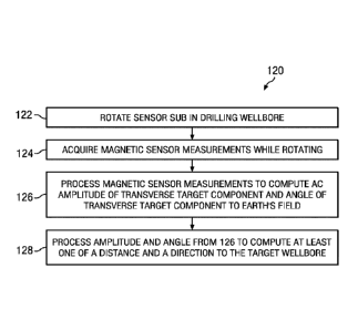
[0062] FIG. 9 depicts a flow chart of another disclosed method embodiment 120.
A
sensor sub including a magnetic field sensor (such as a tri-axial magnetometer
set) is
rotated in a drilling wellbore at 122 in sensory range of AC magnetic flux
emanating from
a target wellbore (note that the sensor sub may optionally, but does not
necessarily,
include accelerometers). Magnetic sensor measurements are acquired at 124
while
rotating in 122 to obtain a magnetic field vector. The measured magnetic field
vector is
processed at 126 to compute at least one of (i) the amplitude of the
transverse component
of the AC magnetic flux emanating from the target wellbore and (ii) the angle
between
the transverse component of the AC magnetic flux emanating from the target
wellbore
18
CA 02953513 2016-12-22
WO 2015/200751
PCMJS2015/037884
and the transverse component of the Earth's magnetic field. The computed
quantity (or
quantities) may then be further processed at 128 to compute at least one of a
distance and
a direction from the drilling well to the target well.
[0063] The disclosed magnetic ranging embodiments may be utilized with a
magnetic
target including substantially any suitable AC magnetization. In such
operations the
target well may include an electromagnet powered by an alternating current
(AC) power
source. The magnetic field about an AC target BT may be expressed
mathematically, for
example, as follows:
BT = BTa sin(cot + c/)) (19)
[0064] where BTõ represents the amplitude of the magnetic field, co represents
the
known frequency, and orti represents an arbitrary phase. When in sensory range
of the
target, the axial (z-axis) magnetic field B, may be expressed as follows:
Bz = BT, (20)
[0065] where Bõ represents the axial component of the Earth's field and BT,
represents
the axial component of the target AC field. It will be understood from
Equation 20 that
the mean value (the DC value) of Bz is equal to Bõ and that the periodic
variations from
the mean may be used to compute the amplitude and phase of BTz. When magnetic
field
measurements are acquired over an interval of several cycles (preferably over
an integer
number of cycles ¨ which may be readily achieved since the source frequency is
known),
the mean value of a set of measured Bz measurements represents the axial
component of
the Earth's field. Thus, subtracting the mean value from each individual B,
measurement
gives the corresponding BTz. These operations may be expressed mathematically,
for
example, as follows:
19
CA 02953513 2016-12-22
WO 2015/200751
PCMJS2015/037884
Bzin =N = Bez (21)
BTz = Bz ¨ (22)
[0066] where Bz, represents the mean value of a set of Bz measurements. The
standard
deviation of the set of B, measurements represents the root mean square (rms)
amplitude
of BTz. The amplitude Bõ of Bz may thus be found by multiplying the root mean
square
value by the square root of two and the phase information sin(cot + c/i) may
be found by
dividing BTz by Bõ. These operations may be expressed mathematically, for
example, as
follows
BTzrms = o(B) (23)
Bza = \f"--
2BTzrms (24)
BTz
sin(cot + cp) = ¨ (25)
Bza
[0067] where BTzrms represents the root mean square amplitude of Bz and a()
represents the standard deviation. While Equations 19, 24 and 25 may imply
that the
target field BT is sinusoidal, the disclosed embodiments are expressly not
limited in this
regard. In practice the target field may deviate from a sine wave, as
nonlinearity and
hysteresis of ferromagnetic materials in the solenoid core and target casing
may distort
the waveform of the magnetic field (even when the input AC current is
perfectly
sinusoidal). The deviation of the magnetic field from a sine wave may be
modeled or
measured and suitable corrections made, if necessary.
[0068] FIG. 10 depicts the transverse (xy) magnetic field vectors. Note that
the
transverse alternating magnetic field B. measured by the rotating x- and y-
axis magnetic
field sensors is the vector sum the transverse components of the Earth's
magnetic field
vector Bõy and the target well's magnetic field vector BT,y. The target field
oscillates
CA 02953513 2016-12-22
WO 2015/200751
PCMJS2015/037884
between positive and negative maxima BTxy (0) and 13Txy(0 + ir) at a frequency
a). As
such the measured field also oscillates at a frequency a) (e.g., between
gxy(0) and
Bxy(4) + 7r) as indicated). The aforementioned vector sum of the transverse
components
may be expressed mathematically, for example, as follows:
Bxy(0) = Bexy B Txy(c()) (26)
100691 With continued reference to FIG. 10, the magnitude of the transverse
component
of the measured magnetic field Bxy may be expressed mathematically, for
example, as
follows (using the law of cosines):
Bxy = \l(Bexy2 BTxy2 ¨ 2Bõ),BTxy cos (9) (27)
[0070] where Bexy represents the magnitude of the transverse component of the
Earth's
field,
¨ Txy represents the magnitude of the transverse component of the target
field, and
61 represents the angle between the transverse components of the Earth's
magnetic field
vector and the target magnetic field vector. The direction of the transverse
component of
the measured magnetic field vector Bxy diverges from the transverse component
Earth's
magnetic field vector Bexy by the angle a where (using the law of sines):
BTxy =sin
sin a = (28)
100711 It will thus be understood that both the amplitude and direction of the
measured
transverse component oscillate with the target field, for example, as follows:
B Txy = B Txyct sin(ot + 0) (29)
[0072] where BT represents
the amplitude of the transverse magnetic field from the
target and where at any time t the corresponding value of sin(a)t + 0) may be
obtained
from the axial measurement (even when the magnetic field is non-sinusoidal).
The
21
CA 02953513 2016-12-22
WO 2015/200751
PCMJS2015/037884
magnitude of the transverse component of the measured magnetic field can be
computed
from the x- and y-axis magnetometer measurements (e.g., B,y2 = Bxe B2).
Combining Equations 27 and 29 enables the magnitude of the transverse
component of
the measured magnetic field to be expressed as a quadratic function of the
phase
sin(tot + cp), for example, as follows:
Bxy2 = BTxya2 s1r12 (co t + (P) ¨ 2 BryeBTxy, cos 6' sin (cot + 4)) + Bxy,2
(30)
[0073] Since sin(a)t + 4)) is known at any instant in time from the axial
magnetic field
measurements (Equation 25), and since corresponding values of Bxy are
measured, a
standard least-squares fit may be applied to determine the quadratic
coefficients BTxya2,
2BxyeBTxya cos 6, and Bxy,2, from which BTxya, Bexy, and 61 may be determined.
These
parameters may then be used to obtain the distance and direction to the target
well as
described in more detail below.
[0074] The coefficients in a quadratic equation y = a = x2 +b=x+c may be
found,
for example, as follows when x and y are known:
Ex4 Ex3 Ex2 -1 Ex2y
b = Ex3 Ex2 Ex x Exy (31)
Xx Xx N Xy
[0075] where y = xy,x = sinGot + cm, and E(.) indicates a sum over a
predetermined number of measurements. For example, measurements may be
acquired at
millisecond intervals for 30 seconds to obtain 3000 accelerometer and
magnetometer
measurements. In an embodiment in which the AC frequency is 10 Hz these
measurements span 300 cycles.
100761 It will be understood that the foregoing discussion has assumed that
the AC
magnetic field emanating from the target is substantially sinusoidal. However,
the
disclosed embodiments are not limited in this regard. In practice, when
ranging to an AC
22
CA 02953513 2016-12-22
WO 2015/200751
PCT/US2015/037884
solenoid, the received magnetic field may be non-sinusoidal. While the
solenoid may be
driven by a sinusoidal current, nonlinear behavior of ferromagnetic materials
in the
solenoid core and/or in the casing may cause the emitted AC magnetic field to
be non-
sinusoidal. In particular, the magnetic field may contain a third harmonic
corresponding
to a depression of the peak values resulting from material nonlinearity as
magnetic
saturation is approached.
[0077] A non-sinusoidal magnetic field may result in biased ranging results
unless
compensation is made. The waveform of the target magnetic field can be
determined
from the measured axial component, or from measurements of transverse
components
during intervals of non-rotation of the magnetic sensors. Corrections for
harmonics (such
as the above described third harmonic) may then be made by modeling their
effect or by
experiments conducted at the surface. Alternatively, the solenoid may be
driven by a
non-sinusoidal current whose waveform is adjusted to produce a sinusoidal
magnetic field
at the receiver. The waveform may be determined by modeling, by experiments
conducted at the surface, or by feedback from real-time measurements of the
received
magnetic waveforms. The disclosed embodiments are not limited in this regard.
[0078] For example, a method for magnetic ranging may include deploying a
magnetic
field sensor in sensory range of magnetic flux emanating from a ferromagnetic
casing
string having an AC magnetic source deployed therein. The casing may be
deployed at
the surface or in a target well. Magnetic field measurements may be processed
to
compute an amplitude of at least one higher order harmonic of the AC magnetic
field.
The AC magnetic source may then be energized with a non-sinusoidal input
electrical
current to reduce (or eliminate) the amplitude of the higher order harmonic.
23
CA 02953513 2016-12-22
WO 2015/200751
PCMJS2015/037884
[0079] The above described magnetic ranging technique tends to be effective
when the
magnitude of 13,3, is a strong function of the target field; i.e., when the
angle 61 in FIG. 10
is small (e.g., less than about 45 degrees). This may be the case when
drilling twin well
pairs for SAGD applications in northern latitudes (where the magnetic dip
angle is high).
However, when the angle between these components is large (e.g., greater than
about 45
degrees), the magnitude of Bxy is less dependent on the target field and thus
it may be
beneficial to alternatively and/or additionally examine the oscillating
direction a. The
direction a may be observed as a regular variation in apparent rotary speed
calculated
using x- and y- axis magnetometers.
[0080] FIG. 11 depicts a flow chart of yet another disclosed method embodiment
140.
A sensor sub including a magnetic field sensor (such as a tri-axial
magnetometer set) is
rotated in a drilling wellbore at 142 in sensory range of AC magnetic flux
emanating from
a target wellbore (note that the sensor sub may optionally, but does not
necessarily
include accelerometers). Magnetic sensor measurements are acquired at 144
while
rotating in 142 to obtain a magnetic field vector. The measured magnetic field
vector is
processed at 146 to compute a difference between an instantaneous rotation
rate and an
average rotation rate of the sensor sub. The computed difference is processed
at 148 to
compute a direction from the drilling well to the target well. The difference
may be
optionally further processed at 150 to compute a distance to the target well.
[0081] At each instant (i.e., at each magnetometer measurement interval - such
as 10
millisecond), an apparent magnetic toolface may be computed, for example, as
described
above with respect to FIG. 2 (M = tan-1(4/By)). The instantaneous rotary speed
rprnt
may be computed from the difference between successive toolface values, for
example, as
follows:
24
CA 02953513 2016-12-22
WO 2015/200751
PCMJS2015/037884
60s
rpmt =¨(2.7) [MOd(Mt ¨ Mt_1 270 ¨ Tr] (32)
[0082] where s represents the magnetometer sample rate (measurement interval).
It
will be understood that the magnetic toolface M is measured with respect to
the transverse
component of the measured magnetic field (i.e., ky). As described above with
respect to
FIG. 10, the direction of ky is offset from the transverse component of the
Earth's
magnetic field Bõy by the angle a which varies at frequency co. Thus, the
calculated
instantaneous rotary speed is directly affected by the rate of change of the
reference
direction, which may be expressed mathematically, for example, as follows:
rpmt = rpmavg ¨Os = ¨d a
(33)
[0083] where rpmavg represents the average rotary speed determined, for
example, via
Equation 14 and da/at represents the rate of change of the angle a which may
be
evaluated by applying the law of sines to the diagram on FIG. 10, for example,
as
follows:
sin a sin(O-Fa)
(34)
Byxy Bexy
[0084] from which it follows that:
BTxy sin
tan a = (35)
Bexy-BT,), cos 0
[0085] Differentiating Equation 35 yields:
aa = aa OBTxY = BexyBTxya=G) COS(a) td-O)Sin 0
(36)
at aBT,), at (13,3,2 + BT xy2 -2se,cyBTry cos 8)
[0086] From Equation 33 the deviation of the measured rotary speed from the
average
rotary speed ilrpm may be given as follows:
60 aa
Arp77/ ¨ (37)
(2rr) at
CA 02953513 2016-12-22
WO 2015/200751
PCMJS2015/037884
[0087] Substituting Equation 36 into Equation 37 yields:
60 eexyeTxycew cos (cut+0) sine
Arprn = (38)
(270 Bexy 2 -I-BTxy2 2 BexyBTxy COS
[0088] In many magnetic ranging operations to an AC target, it may be assumed
that
the Earth's field B0xy is much larger than the target field BTxya such that
Equation 37
may be simplified, for example, as follows:
60 BT,ya sine
Arprn ;z-== co cos(cot + cp) __________________________________ (39)
(2n) Bexy
[0089] Note that in Equation 39 the deviation (or variation) in the measured
rotary
speed Arpm is sinusoidal (proportional to cos(cot + 0)) at the AC excitation
frequency
co with an amplitude equal to BT,),,, = sin9 1Bõy. The amplitude is
proportional BTxya
and may thus be related to the distance from the drilling well to the target
well (e.g., using
one or more of the above described methods). Moreover, the Earth's field B0xy
may be
known from other measurements.
[0090] In many ranging operations employing an AC target, it may be
advantageous to
employ both of the above described methodologies (the first based on the
magnitude of
Bxy described with respect to Equations 27-30 and the second based on the
oscillating
direction described with respect to Equations 31-38). For example, the first
methodology
may be employed to obtain values of BTxya and() while the second methodology
may be
employed to obtain the sign (positive or negative) of sine which indicates
whether the
target is to the right or left of the drilling well. Alternatively, both
methodologies may be
employed simultaneously to provide a more robust solution for BTxya and 6
(i.e., a
solution having reduced noise).
100911 The three components of the AC target magnetic field (BTxya, 61, and Bõ
of the
target) may be resolved into distance and direction by inversion of models or
maps of the
26
CA 02953513 2016-12-22
WO 2015/200751
PCMJS2015/037884
field around the target. For example, the amplitude of the transverse
component of the
target field BT,),õ may be resolved into distance using an empirical or
theoretical model
or map of the target field and the angle B between the Earth's field and the
target field
may be resolved into a toolface to target direction, for example, as follows:
TFT = + (T M) (40)
[0092] where TFT represents the toolface to target direction in the transverse
plane and
(T M) represents the above described toolface offset that may be measured, for
example, using Equation 9 at times when the AC target is not energized.
[0093] It will be understood that while not shown in FIGS. 1 and 2, downhole
measurement tools suitable for use with the disclosed embodiments generally
include at
least one electronic controller. Such a controller may include signal
processing circuitry
including a digital processor (a microprocessor), an analog to digital
converter, and
processor readable memory. The controller may also include processor-readable
or
computer-readable program code embodying logic, including instructions for
computing
various parameters as described above, for example, with respect to the
disclosed
mathematical equations. One skilled in the art will also readily recognize
some of the
above mentioned equations may also be solved using hardware mechanisms (e.g.,
including analog or digital circuits).
[0094] A suitable controller may include a timer including, for example, an
incrementing counter, a decrementing time-out counter, or a real-time clock.
The
controller may further include multiple data storage devices, various sensors,
other
controllable components, a power supply, and the like. The controller may also
optionally communicate with other instruments in the drill string, such as
telemetry
systems that communicate with the surface or an EM (electro-magnetic) shorthop
that
27
CA 02953513 2016-12-22
WO 2015/200751
PCT/US2015/037884
enables the two-way communication across a downhole motor. It will be
appreciated that
the controller is not necessarily located in the sensor sub (e.g., sub 60),
but may be
disposed elsewhere in the drill string in electronic communication therewith.
Moreover,
one skilled in the art will readily recognize that the multiple functions
described above
may be distributed among a number of electronic devices (controllers).
[0095] Although magnetic ranging while rotating and certain advantages thereof
have
been described in detail, it should be understood that various changes,
substitutions and
alternations can be made herein without departing from the spirit and scope of
the
disclosure as defined by the appended claims.
28