Note: Descriptions are shown in the official language in which they were submitted.
CA 02953971 2017-01-06
AIRCRAFT LANDING SYSTEMS AND METHODS
BACKGROUND
1. Technical Field:
This disclosure relates to aircraft radionavigation systems in general, and in
particular, to radar augmented landing systems for aircraft.
2. Related Art:
The only aircraft all-weather precision landing system currently in use is the
well-known Instrument Landing System (ILS), but with the possibility that a
Ground
Based Augmentation System (GBAS) Landing System, or "GLS," will be forthcom-
ing in a few years. However, both of these systems are relatively expensive to
install
and maintain, and in some runway locations, practically difficult to
implement.
To make an ILS approach to a runway in bad weather, the weather must be at
or above certain specified minimum conditions, depending on the "category" of
the
ILS system in effect at that runway, i.e., CAT I, CAT II, or CAT IIIa, TM or
Mc. If
the weather is below the categorization of the ILS, the pilot must revert to a
holding
pattern, in the hope that the weather will improve to that of the CAT level of
the 1LS
to permit a landing, or divert to another airport to land. Landings may not be
made at
airports where the environment is below the ILS categorization level.
Systems used by aircraft to make landing approaches can be categorized as
either "autonomous" (i.e., systems that rely only on equipment disposed aboard
the
aircraft, such as an Inertial Navigation System (INS)) and "other-dependent"
(i.e.,
systems that rely on equipment disposed both aboard the aircraft and
elsewhere, for
example, at the runway, such as an ILS, and/or at another location, e.g.,
orbiting satel-
lites of the Global Positioning System (GPS)).
In general, there is a need in the industry for systems and methods that can
as-
sist in approaching and landing on a runway with such accuracy and integrity
that the
operation can be considered equivalent to an appropriate ILS "category", using
only
equipment on board the aircraft. This would enable the provision of all-
weather land-
ing guidance at almost any location (i.e., with no terrain limitations), and
at minimal
investment in equipment and maintenance costs to airport operators.
SUMMARY
In accordance with the present disclosure, one or more embodiments of sys-
tems and methods are provided that, for example, may supply the required
accuracy
and integrity required to provide all-weather landing guidance using only
equipment
- 1 -
CA 02953971 2017-01-06
on the aircraft, and thereby enable all-weather landing guidance at any
location (i.e.,
without terrain limitations) and at minimal expense to airport operators.
In one example embodiment, a method for controlling an aircraft comprises
storing data aboard the aircraft. The stored data include respective
positions, relative
to each other and to a runway, of a plurality of radar targets, such as
passive radar re-
flectors, disposed within a region adjacent to the runway, and a desired
attitude of the
aircraft relative to the runway. The region is then scanned with a radar
disposed
aboard the aircraft to obtain data corresponding to respective positions,
relative to
each other and to the aircraft, of a plurality of radar reflections from the
region, in-
eluding reflections from the radar targets. The radar data corresponding to
the radar
targets are then distinguished from the radar data corresponding to the radar
reflec-
tions from the region using a correlation algorithm, and a position and an
attitude of
the aircraft relative to the runway is then assessed using the stored data and
the data
corresponding to the radar targets. The position and attitude of the aircraft
relative to
the runway is then assessed using a navigation system that is independent of
the radar,
such as an INS, and differences are then computed between the assessed and
evaluat-
ed positions, and the assessed and the evaluated attitudes, respectively. The
differ-
ences can then be used to correct errors in the assessed position and attitude
of the air-
craft.
In another example embodiment, a system for controlling an aircraft compris-
es a database disposed aboard the aircraft that stores data corresponding to
respective
positions, relative to each other and to a runway, of a plurality of radar
targets dis-
posed within a region adjacent to the runway, and a desired attitude of the
aircraft rel-
ative to the runway. A radar is disposed aboard the aircraft and configured to
scan,
detect and generate data corresponding to respective positions, relative to
each other
and to the aircraft, of a plurality of radar reflections from the region,
including reflec-
tions from the radar targets. A correlator is disposed aboard the aircraft and
config-
ured to distinguish the data corresponding to the radar targets from the data
corre-
sponding to the radar reflections. A navigation system is disposed aboard the
aircraft
and configured to evaluate a position and an attitude of the aircraft relative
to the
runway independently of the radar and using at least one of a global
positioning sys-
tem (GPS), an inertial navigation system (INS), a distance measuring equipment
(DME) system, a very high frequency omnidirectional radio range (VOR) system,
and/or an instrument landing system (ILS). The navigation system is further
config-
ured to assess the position and the attitude of the aircraft relative to the
runway using
- 2 -
the stored data and the radar data corresponding to the radar targets, compute
a posi-
tion difference between the assessed and evaluated positions, compute an
attitude dif-
ference between the assessed and evaluated attitudes, and to control the
aircraft in ac-
cordance with at least one of the position and attitude differences.
In yet another example embodiment, an apparatus for controlling an aircraft
includes a radar disposed aboard the aircraft and configured to scan a region
sur-
rounding a runway and generate radar data corresponding to respective
positions, rela-
tive to each other and to the aircraft, of a plurality of radar reflections
from the region.
A correlator is disposed aboard the aircraft and configured to correlate the
radar data
with data stored aboard the aircraft. The stored data comprises respective
positions,
relative to each other and to the runway, of a plurality of radar targets
disposed within
the region, and a desired attitude of the aircraft relative to the runway, and
to distin-
guish the radar data corresponding to the radar targets from the radar data
correspond-
ing to the radar reflections from the region. A navigation system is disposed
aboard
the aircraft and configured to evaluate a position and an attitude of the
aircraft relative
to the runway independently of the radar. A computer is disposed aboard the
aircraft
and configured to assess the position and the attitude of the aircraft
relative to the
runway using the radar data corresponding to the radar targets and the stored
aircraft
attitude data, and to compute a difference between the evaluated position and
attitude,
and the assessed position and attitude. As above, the difference can be used
to facili-
tate an approach to and landing on the runway by the aircraft, e.g., by
correcting po-
tential errors in the position and attitude of the aircraft as evaluated by
the conven-
tional navigation system.
In yet another example embodiment, a method for controlling an aircraft com-
prises: accessing stored data aboard the aircraft, the data including:
respective posi-
tions, relative to each other and to a runway, of a plurality of radar targets
disposed
within a region adjacent to the runway; and a desired attitude of the aircraft
relative to
the runway; scanning the region with a radar disposed aboard the aircraft to
obtain
radar data corresponding to respective positions, relative to each other and
to the air-
craft, of a plurality of radar reflections from the region, including
reflections from the
radar targets; distinguishing the radar data corresponding to the radar
targets from the
radar data corresponding to the radar reflections; assessing a position and an
attitude
of the aircraft relative to the runway using the stored data and the radar
data corre-
sponding to the radar targets; evaluating the position and the attitude of the
aircraft
relative to the runway using a navigation system that is independent of the
radar;
- 3 -
Date Recue/Date Received 2020-11-17
computing a difference between the assessed position and the evaluated
position;
computing a difference between the assessed attitude and the evaluated
attitude; and
controlling the aircraft in accordance with at least one of the position
difference and
the attitude difference.
In yet another example embodiment, a system for controlling an aircraft
comprises: a database disposed aboard the aircraft and storing data
corresponding to:
respective positions, relative to each other and to a runway, of a plurality
of radar
targets disposed within a region adjacent to the runway; and a desired
attitude of the
aircraft relative to the runway; a radar disposed aboard the aircraft and
configured to
scan, detect and generate data corresponding to respective positions, relative
to each
other and to the aircraft, of a plurality of radar reflections from the
region, including
reflections from the radar targets; a correlator disposed aboard the aircraft
and
configured to distinguish the radar data corresponding to the radar targets
from the
radar data corresponding to the radar reflections; and a navigation system
disposed
aboard the aircraft and configured to: assess a position and an attitude of
the aircraft
relative to the runway using the stored data and the radar data corresponding
to the
radar targets; evaluate the position and the attitude of the aircraft relative
to the
runway independently of the radar using at least one of a global positioning
system,
an inertial navigation system, a distance measuring equipment system, a very
high
frequency omnidirectional radio range system, and an instrument landing
system;
compute a difference between the assessed position and the evaluated position;
compute a difference between the assessed attitude and the evaluated attitude;
and
control the aircraft in accordance with at least one of the position and
attitude
differences.
In yet another example embodiment, an apparatus for controlling an aircraft
comprises: a radar disposed aboard the aircraft and configured to: scan a
region
surrounding a runway; and generate radar data corresponding to respective
positions,
relative to each other and the aircraft, of a plurality of radar reflections
from the
region; a correlator disposed aboard the aircraft and configured to: correlate
the radar
data with data stored aboard the aircraft, the stored data comprising
respective
positions, relative to each other and the runway, of a plurality of radar
targets
disposed within the region and a desired attitude of the aircraft relative to
the runway;
and distinguish the radar data corresponding to the radar targets from the
radar data
corresponding to the radar reflections; a navigation system disposed aboard
the
aircraft and configured to evaluate a position and an attitude of the aircraft
relative to
- 3a -
Date Recue/Date Received 2020-11-17
the runway independently of the radar; a computer disposed aboard the aircraft
and
configured to: assess the position and the attitude of the aircraft relative
to the runway
using the radar data corresponding to the radar targets and the stored
aircraft position
and attitude data; and compute a difference between the assessed position and
attitude
of the aircraft and the evaluated position and attitude of the aircraft; and a
controller
configured to control movement of the aircraft at least in part as a function
of the
difference.
In yet another example embodiment, an apparatus for controlling an aircraft,
the apparatus comprising: a radar disposed aboard the aircraft and configured
to: scan
a region surrounding a runway; and generate radar data corresponding to
respective
positions, relative to each other and the aircraft, of a plurality of radar
reflections from
the region, including reflections from radar targets; a correlator disposed
aboard the
aircraft and configured to: correlate the radar data with data located aboard
the
aircraft, the data comprising respective positions, relative to each other and
the
runway, of a plurality of radar targets disposed within the region relative to
the
runway, and a desired attitude of the aircraft relative to the runway; and
distinguish
the radar data corresponding to the radar targets from the radar data
corresponding to
the radar reflections; a navigation system disposed aboard the aircraft and
configured
to evaluate a position and an attitude of the aircraft relative to the runway
independently of the radar; a computer disposed aboard the aircraft and
configured to:
assess the position and the attitude of the aircraft relative to the runway
using the
radar data corresponding to the radar targets and the data located aboard the
aircraft;
and compute a difference between the assessed position and attitude of the
aircraft
and the evaluated position and attitude of the aircraft; and a controller
configured to
.. control movement of the aircraft at least in part as a function of the
difference.
The scope of this invention is defined by the appended claims, which are in-
corporated here by reference. A better understanding of the novel systems and
meth-
ods of the present disclosure, as well as an appreciation of the above and
additional
advantages thereof, will be afforded to those of some skill in the art by a
consideration
of the following detailed description of one or more example embodiments
thereof. In
this description, reference is made to the various views of the appended
sheets of
drawings, briefly described below, within which like reference numerals are
used to
identify like ones of the elements illustrated therein.
- 3b -
Date Recue/Date Received 2020-11-17
CA 02953971 2017-01-06
BRIEF DESCRIPTION OF THE SEVERAL VIEWS OF THE DRAWINGS
Fig. 1 is functional block diagram of an example embodiment of a system for
controlling an aircraft to facilitate an all-weather, precision approach to
and landing
on a runway in accordance with the present invention;
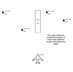
Fig. 2 is a plan view of an aircraft approaching a runway that has a plurality
of
radar targets disposed within a region adjacent to the runway in accordance
with an
example embodiment of the present invention;
Fig. 3 is a plan view of the aircraft and region of Fig. 2, showing a
plurality of
radar reflections from the region as a result of the region being scanned by a
radar
disposed aboard the aircraft;
Fig. 4 is a plan view of the aircraft and region of Fig. 3, showing the radar
re-
flections corresponding to the radar targets being distinguished from the
other radar
reflections returning from the region;
Fig. 5 is a plan view of the aircraft and region of Fig. 4, showing
differences
between the respective position and attitude of the radar targets, as stored
in a data-
base aboard the aircraft, and as distinguished by the radar, respectively,
being used to
compute aircraft position and attitude errors; and
Fig. 6 is a process flow diagram of an example embodiment of a method for
controlling an aircraft in accordance with the present disclosure.
DETAILED DESCRIPTION
The only existing all-weather landing system currently in use is ILS Category
III (i.e., CAT IIIa, Illb or IIIc). It is expected that GLS will be expanded
to include
CAT III operations at some point in the future. However, both ILS and GLS are
lim-
ited in the locations in which they can be installed due to terrain factors
that impact
the propagation of the guidance signals. In addition, CAT III requires
relatively ex-
pensive monitoring and periodic calibration work, making its implementation
and
maintenance relatively exorbitant for, e.g., developing nations. Thus, even
assuming
that GLS is eventually approved for CAT III operations, its implementation
will still
be limited due to the cost of the ground infrastructure that must be installed
and main-
tamed at each airport.
One or more embodiments of the present disclosure may, for example, supply
the requisite accuracy and integrity required to facilitate all-weather
landing guidance
using only equipment disposed on board the aircraft, and thereby provide all-
weather
landing guidance at almost any runway location and at a relatively minimal
expense
to airport operators.
- 4 -
CA 02953971 2017-01-06
Fig. 1 is functional block diagram of an example embodiment of a system 100
for controlling an aircraft 110 so as to facilitate an all-weather, precision
approach to
and landing on a runway 112 in accordance with the present disclosure. In the
exam-
ple embodiment of Fig. 1, the control system 100 comprises a pair of
substantially
identical navigation systems, viz., a "left" navigation system 102 and a
"right" navi-
gation system 104, which operate redundantly, i.e., in parallel with each
other, for
purposes of reliability and safety. Each of the redundant navigation systems
102 and
104 comprises a navigation database 106 or 108 that stores data essential to
the navi-
gation of the aircraft 110, including the relative position and attitude data
described
below in connection with Figs. 2 ¨ 5.
Fig. 2 is a plan view of an aircraft 110 approaching a runway 112 that has a
plurality of radar targets 114 disposed within a region located adjacent to
the runway
112. In accordance with the present invention, the radar targets 114 can
comprise ei-
ther "man-made" targets, e.g., buildings, water, radio or TV towers, dihedral
or trihe-
dral radar "retroreflectors" of known types, or alternatively, "natural"
targets, e.g.,
hills, valleys, lakes, quarries, or the like. As contemplated herein, the
radar targets 114
preferably comprise radar retroreflectors because they are fixed, relatively
simple and
inexpensive to make, install and maintain, and because they provide relatively
reliable
radar signal returns or reflections at known, relatively high and consistent
signal 1ey-
els, when compared with those of the other man-made or the natural reflectors.
As discussed in more detail below, it is desirable to obtain and store in the
da-
tabases 106 and 108 of the aircraft 110 certain dimensional data pertaining to
the air-
craft 110, the runway 112, and the radar targets 114. In particular, that data
corre-
spond to the respective positions, relative to each other and to the runway
112, of the
.. radar targets 114, and a desired attitude of the aircraft 110 relative to
the runway 112.
The target 114 and runway 112 data can be obtained, for example, by surveying
the
radar targets 114 and runway 112 using conventional engineering surveying tech-
niques, and the desired attitude of the aircraft 110 relative to the runway,
e.g., at
touchdown, can typically be specified.
As illustrated Fig. 1, the example control system 100 further comprises a
radar
116, e.g., a weather radar of a type commonly disposed aboard a modern
commercial
jet aircraft. As discussed below, the radar 116, in addition to supplying
conventional
aircraft weather and collision avoidance functions, can also function as an
important
adjunct to the navigation systems 102 and 104 in providing all-weather runway
ap-
proach and landing guidance at almost any runway.
- 5 -
CA 02953971 2017-01-06
Thus, as illustrated in Fig. 3, the radar 116 can be configured to scan,
detect
and generate data corresponding to respective positions, relative to each
other and to
the aircraft 110, of a plurality of radar returns or reflections 118 from the
region adja-
cent to the runway 110, including reflections from the radar targets 114. As
can be
seen from a comparison of Figs. 2 and 3, the radar reflections 118 of the
radar beam
120 returning from the region scanned by the radar 116 can, and typically do,
include
other radar reflections 118 as a result of ground clutter and other radar
reflecting sur-
faces of objects located within the scanned region, which can lead to a
reliance on in-
correct position and attitude data from the radar returns 118. Accordingly,
before the
reflections 118 from the radar targets 114 can be used to control the aircraft
110 accu-
rately and reliably, it is first necessary to distinguish the radar data
corresponding to
the actual radar targets 114 from the spurious radar data corresponding to the
other
reflecting objects.
As illustrated in Fig. 1, this distinguishing function can be effected by a
pair of
correlators 122 and 124 respectively disposed in each of the navigation
systems 102
and 104 of the aircraft 100. In one advantageous embodiment, each of the
correlators
122 and 124 can comprise a computer running software comprising a target
correla-
tion algorithm that correlates the respective positions of the radar
reflections 118 rela-
tive to each other, as obtained by the radar 116, with the respective
positions of the
radar targets 114 relative to each other, as previously stored in the
databases 106 and
108 of the aircraft 110. There are a number of target correlation algorithms
that can be
used to distinguish the data corresponding to the radar targets 114 from among
the
data corresponding to the radar reflections 118.
For example, a high correlation coefficient between the respective positions
of
the scanned radar targets 114 and the stored radar targets 114 can indicate
that the ra-
dar data corresponding to the former are correct, whereas, a small or even
negative
correlation coefficient can indicate that the radar data correspond to other
objects, ra-
ther than the true targets 114. Since the relationship between the respective
positions
of the targets 114 is linear, the correlation coefficients derived by the
correlation algo-
rithm of the correlators 122 and 124 could comprise, for example, the well-
known
"Pearson" correlation coefficient.
Fig. 4 is a plan view of the aircraft 110 and region of Fig. 3, showing the
radar
reflections 118 corresponding to the radar targets 114 being distinguished
from the
other radar reflections 118 returning from the region using the target
correlation algo-
rithm.
- 6 -
CA 02953971 2017-01-06
As illustrated in Fig. 5, once the position and attitude of the actual radar
tar-
gets 114 relative to the radar 116 has been determined, any differences or
errors in the
position and attitude of the aircraft 110 relative to the targets 114, and
hence, to the
runway 110, can be assessed mathematically from the radar return target data
and the
stored target data using well-known arithmetic and trigonometric
transformations. As
illustrated in Fig. 1, for this purpose, each of the navigation systems 102
and 104 of
the aircraft 110 can be provided with a navigation function computer 126 or
128. The
"difference" or "error" data computed can be used to control the aircraft 110
to effect
an all-weather, precision approach to and landing on the runway 112 in
cooperation
with a conventional navigation, approach and landing system, as discussed in
more
detail below.
For example, as illustrated in Fig. 1, the control system 100 can include a
group of external systems 130, including an autopilot 132, one or more
displays 134,
a Flight Management System (FMS) 136, and the like. Thus, in one embodiment,
the
autopilot 132 can be configured to control the aircraft 110 in accordance with
the
computed difference or error data. As contemplated herein, "control" means
adjusting
both the rectilinear movement of the center of gravity (CG) of the aircraft
110, and the
angular movement of the aircraft about each of the pitch, yaw and roll axes of
the air-
craft 110.
In another embodiment, the display 134, which can comprise a so-called
"heads up display" (HUD), can be configured to generate and present to a pilot
of the
aircraft 110 a visual presentation of the difference or error data, including
an artificial
representation of the runway 112, as illustrated in Fig. 5, and the control of
the aircraft
110 can be effected manually by the pilot using the display 134.
As discussed above, modern commercial aircraft 110 are typically equipped
with a variety of conventional systems used for navigation, runway approach,
and/or
landing functions. As illustrated in the particular example embodiment of Fig.
1, these
conventional systems can include, for example, redundant pairs of global
positioning
systems (GPSs) 138, 140, inertial navigation systems (INSs) 142, 144, distance
meas-
tiring equipment (DME) systems 146, 148, very high frequency omnidirectional
radio
range (VOR) systems 150, 152, and instrument landing systems (ILSs) 154, 156.
As
discussed above, one or more of these systems can be configured to evaluate
the posi-
tion and the attitude of the aircraft 110 relative to the runway 112
independently of
the radar 116, and to use that evaluation to effect an all-weather, precision
approach to
and landing on the runway 112 under the appropriate conditions.
- 7 -
CA 02953971 2017-01-06
However, if the position and attitude of the aircraft 110 relative to the
runway
112 as assessed independently by the radar 116 is also available as above,
then the
difference between the assessed and evaluated positions can be computed and
used to
control the aircraft 110 in accordance with the difference. That is, the above
radar ap-
.. proach and landing system can be used as a "backstop" for the conventional
approach
and landing system of the aircraft 110, in which the former can be used to
correct any
errors in the latter's position and attitude determinations. For example, the
contribu-
tion of each of the two independent systems to a determination of an "actual"
position
and attitude of the aircraft 110 relative to the runway 112 can be weighted in
accord-
ance with the confidence in the respective reliability and accuracy of the two
systems,
which might vary, for example, as a function of the distance between the
aircraft 110
and the runway 112.
Fig. 6 is a process flow diagram of an example embodiment of a method 200
for controlling the aircraft 110 in accordance with the present disclosure. As
discussed
.. above, the method 200 begins at Si with storing data in the databases 106
and 108 of
the aircraft 110. As above, the data include the respective positions,
relative to each
other and to the runway 112, of a plurality of radar targets 114 disposed
within a re-
gion adjacent to the runway 112, as well as a desired attitude of the aircraft
110 rela-
tive to the runway 112.
At S2, the region adjacent to the runway 112 is then scanned with the radar
116 of the aircraft 110 to obtain radar data corresponding to the respective
positions,
relative to each other and to the aircraft 110, of a plurality of radar
returns or reflec-
tions 118 from the region, including reflections from the radar targets 114.
The radar
data corresponding to the radar targets 114 is then distinguished from the
radar data
corresponding to the radar reflections 118 using the correlators 122 and 124
and the
target correlation algorithm, and at S3, the position and attitude of the
aircraft 110 rel-
ative to the runway 112 is then assessed by the navigation function computers
126 and
138 using the stored data and the radar data determined to correspond to the
radar tar-
gets 114.
At S4, the position and the attitude of the aircraft 110 relative to the
runway
112 is then evaluated in conjunction with the radar assessment using the
navigation
function computers 126 and 128 and data supplied by at least one of the
conventional
navigation systems 138 ¨ 156, and at SS, the difference between the assessed
position
and attitude and the evaluated position and attitude are computed, and the
difference
- 8 -
is input to the autopilot 132 to effect control of the aircraft 110 at least
in part in ac-
cordance with the difference.
At S6, a decision is made as to whether the process 200 has been completed. If
no," the process flow returns to S2 for a recursion of the steps S3 - S5
described
above, and if -yes," then the process is terminated.
As those of some skill in this art will by now appreciate, and depending on
the
specific application at hand, many modifications, substitutions and variations
can be
made in and to the materials, apparatus, configurations and methods of use of
the air-
craft all-weather, precision control systems of present disclosure without
departing
from its spirit and scope. In light of this, the scope of the present
invention should not
be seen as limited to those of the particular embodiments illustrated and
described
herein, as they are merely by way of some examples thereof, but rather, should
be ful-
ly commensurate with that of the claims appended hereafter and their
functional
equivalents.
- 9 -
Date Recue/Date Received 2020-11-17