Note: Descriptions are shown in the official language in which they were submitted.
WELL RANGING APPARATUS, SYSTEMS, AND METHODS
BACKGROUND
[0002] With much of the world's easily obtainable oil having already been
produced, new techniques are being developed to cxtract less accessible
hydrocarbons. These techniques often involve drilling a borehole in close
proximity to one or more existing wells. Examples of directed drilling near an
existing well include well intersection for blowout control, multiple wells
drilled
from an offshore platform, and closely spaced wells for geothermal energy
recovery. Another such technique is steam-assisted gravity drainage (SAGD)
that uses a pair of vertically-spaced, horizontal wells constructed along a
substantially parallel path, often less than ten meters apart. Careful control
of the
spacing contributes to the effectiveness of the SAGD technique.
[0003] One way to construct a borehole in close proximity to an existing well
is
"active ranging" or "access-dependent ranging" in which an electromagnetic
source is located in the existing well and monitored via sensors on the drill
string
in the well under construction. Another technique involves systems that locate
both the source and the sensor(s) on the drill string ¨ relying on backscatter
transmission from the target well to determine the range between the drilling
well and the target well. These latter systems are sometimes called "passive
ranging" or "access-independent" systems by those of ordinary skill in the
art. In
either case, the ranging techniques are sometimes limited in the degree of
accuracy that can be obtained.
1
CA 2954303 2018-05-29
CA 02954303 2017-01-04
WO 2016/025232
PCT/US2015/043566
BRIEF DESCRIPTION OF THE DRAWINGS
[0004] FIG. 1 depicts an example drilling environment in which
ranging
embodiments may be employed.
[0005] FIG. 2 is a block diagram of a well ranging apparatus, shown
in
perspective and top views, for various embodiments.
[0006] FIG. 3 is a block diagram of a well ranging apparatus, for
various
embodiments.
[0007] FIG. 4 is a flow diagram of a well ranging method, for various
embodiments.
[0008] FIGs. 5-20 illustrate a variety of apparatus embodiments.
[0009] FIG. 21 is a block diagram of a wireline system implementation
of various embodiments.
[0010] FIG. 22 is a block diagram of a drilling system implementation
of
various embodiments.
DETAILED DESCRIPTION
Introduction
[0011] Magnetic ranging has been widely used for various
applications,
including well intersection, well avoidance, SAGD, and others. One excitation
method for magnetic ranging is surface excitation. Surface excitation is a
popular method of generating a ranging signal. It is relatively easy to
implement,
without the need for complex cabling and equipment. When surface excitation is
used, a current is injected into a target well casing at the surface of the
well (e.g.,
at the well head). The current travels along the casing down-hole and
generates
a magnetic field down-hole that originates from the target via direct
transmission, and can be measured at a distance (e.g., in a drilling well) for
ranging purposes. As a result, the excitation signal down-hole may be
relatively
weak when the distance beneath the surface is great, due to the current
leakage
into conductive formations. Consequently, sensor noise often affects magnetic
ranging accuracy at greater depths, leading to false signal measurements and
failures in well location. Some of the embodiments described herein are
designed to improve down-hole current strength and/or enhance the signal/noise
ratio, for improved accuracy with respect to ranging measurement technology.
2
CA 02954303 2017-01-04
WO 2016/025232
PCT/US2015/043566
[0012] Such apparatus, methods, and systems can be even more useful
when backscatter ranging is used: that is, when the excitation source is
injected
into the casing of the drilling well, or is attached to a drill string within
the
drilling well. In the case of backscatter ranging, the excitation source
originates a
direct transmission signal that impinges upon, and is then reflected from, the
target well. When these backscatter transmission signals are received at a
receiver in the drilling well, the resulting received ranging signals are even
weaker than in the direct transmission case.
[0013] Thus, novel apparatus, methods, and systems are proposed to
increase the strength of the received ranging signal, to improve the received
signal-to-noise ratio (SNR), and to improve the accuracy of ranging signal
measurements. In some embodiments, enhancements are realized in all three of
these areas. By taking this approach, ranging system technology can be
improved in a number of ways, via improved accuracy and reliability of
individual ranging measurements. Therefore, the apparatus, methods, and
systems proposed herein can be used to reduce measurement issues that arise
due
to noise, as well as to generate larger signals at great depths. The result is
that
the maximum detection ranges for existing ranging systems can be significantly
improved. In some embodiments, the apparatus, methods, and systems described
herein can be applied to electromagnetic (EM) telemetry applications.
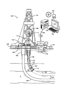
[0014] FIG. 1 depicts an example drilling environment 100 in which
ranging embodiments may be employed. The disclosed apparatus (e.g., logging
tools), systems, and methods are best understood in the context of the larger
systems in which they operate. Accordingly, FIG. 1 illustrates an example
drilling environment 100 in which a drilling platform 102 supports a derrick
104
having a traveling block 106 for raising and lowering a drill string 108. A
top
drive 110 supports and rotates the drill string 108 as it is lowered through
the
well-head 112. A drill bit 114 is driven by a downhole motor and/or rotation
of
the drill string 108. As the drill bit 114 rotates, it creates a borehole 116
that
passes through various formations E. A pump 118 circulates drilling fluid
through a feed pipe 120 to top drive 110, downhole through the interior of
drill
string 108, through orifices in drill bit 114, back to the surface via the
annulus
around drill string 108, and into a retention pit 122. The drilling fluid
transports
3
CA 02954303 2017-01-04
WO 2016/025232
PCT/US2015/043566
cuttings from the borehole into the retention pit 122 and aids in maintaining
the
borehole integrity.
[0015] The drill bit 114 is just one piece of a bottom-hole assembly
(BHA) that includes one or more drill collars (comprising thick-walled steel
pipe) to provide weight and rigidity to aid the drilling process. Some of
these
drill collars include logging instruments to gather measurements of various
drilling parameters such as position, orientation, weight-on-bit, borehole
diameter, etc. The tool orientation may be specified in terms of a tool face
angle
(also known as rotational or azimuthal orientation), an inclination angle (the
slope), and a compass direction, each of which can be derived from
measurements made by magnetometers, inclinometers, and/or accelerometers,
though other sensor types such as gyroscopes may also be used. In one specific
embodiment, the tool includes a three-axis fluxgate magnetometer and a three-
axis accelerometer. As is known in the art, the combination of these two
sensor
systems enables the measurement of the tool face angle, inclination angle, and
compass direction. In some embodiments, the tool face and hole inclination
angles are calculated from the accelerometer sensor output, and the
magnetometer sensor outputs are used to calculate the compass direction.
[OM] The BHA further includes a ranging tool 124 to receive signals
from current injected by a power supply 148 into nearby conductors such as
pipes, casing strings, and conductive formations and to collect measurements
of
the resulting field to detcimine distance and direction. Using measurements of
these signals, in combination with the tool orientation measurements, the
driller
can, for example, steer the drill bit 114 along a desired path in the drilling
well
126 relative to the existing well (e.g., target well) 128 in formation F using
any
one of various suitable directional drilling systems, including steering
vanes, a
"bent sub", and a rotary steerable system. For precision steering, the
steering
vanes may be the most useful steering mechanism. The steering mechanism can
be controlled from the Earth's surface, or downhole, with a downhole
controller
programmed to follow the existing borehole 128 at a predetermined distance 130
and position (e.g., directly above or below the existing borehole).
[0017] The ranging tool 124 may comprise one or more elements,
interchangeably designated as receivers or sensors in this document. These
4
CA 02954303 2017-01-04
WO 2016/025232
PCT/US2015/043566
elements may comprise uniaxial, biaxial, or triaxial magnetometers, coil
antennas, and/or telemetry receivers.
[0018] A telemetry sub 132 coupled to the downhole tools (including
ranging tool 124) transmits telemetry data to the surface via mud pulse
telemetry. A transmitter in the telemetry sub 132 modulates a resistance to
drilling fluid flow to generate pressure pulses that propagate along the fluid
stream at the speed of sound to the surface. One or more pressure transducers
134 convert the pressure signal into electrical signal(s) for a signal
digitizer 136.
Note that other forms of telemetry exist and may be used to communicate
signals
from downhole to the digitizer. Such telemetry may include acoustic telemetry,
electromagnetic telemetry, or telemetry via wired drill pipe.
[0019] The digitizer 136 supplies a digital form of the telemetry
signals
via a communications link 138 to a computer 140 or some other fortn of a data
processing device. The computer 140 operates in accordance with software
(which may be stored on non-transitory information storage media 142) and user
input provided via an input device 144 to process and decode the received
signals. The resulting telemetry data may be further analyzed and processed by
the computer 14010 generate a display of useful information on a computer
monitor 146 or some other form of a display device. For example, an oil field
service provider could employ this system to obtain and monitor drilling
parameters, formation properties, and/or the path of the borehole relative to
the
existing borehole 128 and any detected formation boundaries. A downlink
channel can then be used to transmit steering commands from the surface to the
BHA. In some embodiments, the computer 140 has analog circuitry installed or
is programmed to include a ranging determination module RD, which operates
on the signal data received down hole at the ranging tool 124 to determine the
distance and direction from the drilling well 126 to the target well 128. The
ranging determination module RD may exist in the computer 140 or the tool 124,
and may be used to implement any of the methods described herein.
[0020] Thus, FIG. 1 illustrates an electromagnetic ranging system with
surface excitation. The power supply 148 at the surface employs a cable 150 to
inject current into target well casing 152 and flowing down-hole so that
magnetic fields can be generated surrounding a target well 128. Then sensors
in
5
CA 02954303 2017-01-04
WO 2016/025232
PCT/US2015/043566
the ranging tool 124 in the drilling well 126 can determine the magnetic field
strength in various directions so that distance and direction between the
target
well 128 and drilling well 126 can be determined. The power supply 148 can
also be connected to inject current into the casing of the drilling well 126.
[0021] The drilling well 126 and the target well 128 are often constructed
as a cased hole, with cement installed around the outside of the casing
material
(e.g., conductive piping). In the completion phase of oil and gas wells, the
cement serves to isolate the wellbore, helps prevent casing failure, and keeps
the
wellbore fluids from contaminating freshwater aquifers.
[0022] Tool configurations are described to enable gradient field
measurements from, in some embodiments, substantially equally spaced sensors.
Various embodiments are suitable for steam-assisted gravity drainage (SAGD)
ranging applications (e.g., parallel ranging), as well as T-intersection
ranging
applications (e.g., well avoidance or well intersection applications).
Detailed Presentation
[0023] Sometimes the BHA is oriented with respect to the target well
such that electromagnetic ranging sensors provide nearly equal field strength
measurements. In effect, the sensors provide little or no differentiation as
to
distance from the target well, because the measured field strength components
for each sensor are not substantially different. This situation makes it
difficult or
impossible to determine the range to the target well when the gradient field
is
used to make the range determination, hi some embodiments, the tool
configuration is used to enable determination of gradient fields from sensors
in
various ranging applications.
[0024] FIG. 2 is a block diagram of a well ranging apparatus 200, shown
in perspective and top views, for various embodiments. Here the perspective
view shows a housing 210, such as a down hole ranging tool housing or BHA,
and at least three sensors Sl, S2, and S3 attached to the BHA or other drill
string
component (that form the housing 210). The sensors Si, S2, S3 are not in the
same azimuthal plane (e.g., here no two sensors are in the same azimuthal
plane
¨ each occupies its own respective azimuthal plane: Si in Plane 1, S2 in
Plane2,
and S3 in Plane3). The sensors Si, S2, and S3 are approximately equally spaced
around the longitudinal axis z, as shown in the top view of figure. This
simplifies
6
CA 02954303 2017-01-04
WO 2016/025232
PCT/US2015/043566
gradient field calculations (although it is noted that in some embodiments,
configurations with unequal spacing are used), to determine the range for any
orientation of the target well with respect to the drilling well. Reference
designations for the lines Sl-S2, S2-S3, and Sl-S3, as well as for the
separation
between the sensors ASsi_s, are shown in FIG. 2, to support additional
calculations that may be applied to additional embodiments.
[0025] For example, a finite difference method may be used to
calculate
total field and gradient field from two sensors Sl, S2, as:
+ 1/7
H _____________________
OH (H1-112)
ar 2S
Then, using sensors Si and S2, ranging sensitivity is given along the
direction of the line Sl-S2, with the total field and gradient field along the
Line S1-S2, as follows:
HS + fIS2
H51_52 ¨ 2
OH (Hsi¨H2)
S1¨S2 2S_2
Similarly, the ranging sensitivity direction can be evaluated along a line
through sensors S2-S3 (Line S2-S3) and along a line through sensors Sl-S3
(Line S1 -S3), using the pair of sensors S2 and 53, and the pair of sensors Si
and S3, respectively.
[0026] FIG. 3 is a block diagram of a well ranging apparatus 300, for
various embodiments. In some embodiments, a pair of sensors can be used to
create a pseudo-sensor. Additional reference designations are thus added to
the
figure, such as the line through sensors Si, S2 (i.e., Line Sl-S2), the line
through
sensor S3 and the pseudo-sensor (Line S3-S12), and the distance between the
line through sensors Si, S2 (Line Si -S2) and the pseudo-sensor, along the
Line
7
CA 02954303 2017-01-04
WO 2016/025232
PCT/US2015/043566
S3-S12 (i.e., ASs3-s12), to support additional calculations that may be
applied to
this embodiment.
[0027] Thus, in some embodiments, a first pair of two sensors (e.g.,
Sensors Si and S2) can be used to create a pseudo sensor (Sensor S12) in the
middle of the two selected physical Sensors Si and S2. To determine the total
field:
H5I + H52
H512 =
10028] Using the pseudo sensor S12 together with another available
sensor (e.g., Sensor S3), a total field and gradient field can be generated in
a new
ranging sensitivity direction (e.g., along Line S3-512). The formulas to
determine the total field and gradient field along this line arc as follows:
H53 HS12
11153 ¨.512 =
all (1153-11s12)
r S3-S12 2M3_12
[0029] The generation of different ranging sensitivity directions, as
described with respect to FIG. 3 can be applied to any of the embodiments
described herein. The measurement of the field strength H at each sensor may
include tangential, normal, or longitudinal components, or any of the three
components with respect to different ranging applications
[0030] FIG. 4 is a flow diagram of a well ranging method 411, for
various embodiments. Calibration may become more difficult when the sensors
are not in separate azimuthal planes, or not equally spaced from each other
according to an angle e around the longitudinal axis z, as shown in FIG. 3. In
some embodiments, more than three sensors are used. The method 411 may
include a method of using the apparatus 300 shown in FIG. 3.
[0031] Thus, in some embodiments, a method 411 begins at block 421
with acquiring the sensor orientation and spacing. The method 411 may continue
8
CA 02954303 2017-01-04
WO 2016/025232
PCT/US2015/043566
at block 425 with measuring the total magnetic field if at each sensor, such
as
the tangential, normal, and z components of the magnetic field with respect to
the BIIA. Some embodiments of the method 411 continue on to block 429 with
determining three or more gradient field values (e.g., vectors) from the total
magnetic field ji measurements. In some embodiments, the method 411
comprises using the gradient field values determined at block 429 to determine
the range between wells, at block 433.
[0032] Calculations can be made to account for the separation
distance
between sets of two sensors, in the azimuthal direction shown by the angle 0
(see FIG. 2), and in the longitudinal direction z (see FIGs. 2 and 3). When
the
separation is known in one or both directions, calculations can be simplified,
and
the operations of the related computing apparatus can be improved due to a
reduction in the number of operations involved in determining an approximate
range distance. The magnetic field that is measured can result from current
injected at the target well, or via backscatter from the target well.
[0033] FIGs. 5-20 illustrate a variety of apparatus embodiments. Each
of
the embodiments comprises one possible arrangement of an insert and sensors
Si, S2, S3, among many possible arrangements. In some embodiments, an insert
may comprise a tool insert, such as a BHA insert, including a ranging tool
housing.
[0034] For example, FIGs. 5-8 illustrate vertical, perspective, top,
and
horizontal views, respectively, of an insert with three sensors Sl, S2, S3
attached
at different azimuthal and longitudinal locations ¨ so that none of the
sensors has
its azimuthal or longitudinal location in common with any of the others.
Sensors
S1 and S3 are approximately equidistant from sensor S2 in the longitudinal
direction.
[0035] FIGs. 9-12 illustrate vertical, perspective, top, and
horizontal
views, respectively, of an insert with three sensors Si, S2, S3 attached at
different azimuthal and longitudinal locations ¨ so that none of the sensors
has
its azimuthal or longitudinal location in common with any of the others.
However, in this case, sensors Si and S3 are approximately equidistant from
sensor S2 in the longitudinal direction, as well as the azimuthal direction.
9
CA 02954303 2017-01-04
WO 2016/025232
PCT/US2015/043566
[0036] FIGs. 13-16 illustrate vertical, perspective, top, and
horizontal
views, respectively, of an insert with three sensors Si, S2, S3 attached at
different azimuthal locations; and sensors Si, S3 having a common longitudinal
location. Thus, sensors S1 and S3 are approximately equidistant from sensor S2
in the longitudinal direction. Sensors Si and S3 are also approximately
equidistant from sensor S2 in the azimuthal direction.
[0037] FIGs. 17-20 illustrate vertical, perspective, top, and
horizontal
views, respectively, of an insert with four sensors SI, S2, S3, S4 attached.
Sensors S2, S3 have a common azimuthal location, and sensors SI, S2, S4 have
a common longitudinal location. Thus, sensors Sl, S2, S4 are approximately
equidistant from sensor S3 in the longitudinal direction, and sensors Si and
52,S3 are approximately equidistant from sensor S4 in the azimuthal direction.
[0038] These solutions help reduce the effect of leakage current
signals
in the BHA by utilizing directional sensitivity to achieve ranging
determination.
The methods disclosed herein are useful for applications such as steam-
assisted
(SAGD), well avoidance, and well interception. The measured magnetic field at
the ranging tool can result from current injected at the target well, or via
backscatter radiation from the target well.
Additional Detailed Description and Some Representative
Embodiments
[0039] FIG. 21 is a block diagram of a wireline system 2100
implementation of various embodiments. The system 2100 of FIG. 21 may
include any of the embodiments of receiver or sensor mounting discussed
previously. In this case, a hoist 2106 may be included as a portion of a
platform
2102, such as coupled to a derrick 2104, and used to raise or lower equipment
such as a wireline sonde 2110 into or out of a borehole. The wireline sonde
2110
may include any one or more of the above-described embodiments, including
sensors Si, S2, S3, S4 and a range determination module RD.
100401 In this wireline example, a cable 2142 may provide a
communicative coupling between a logging facility 2144 (e.g., including a
processor circuit 2145 including memory or other storage or control circuitry)
and the sonde 2110. In this manner, information about the formation 2118 may
be obtained. The processor circuit 2145 can be configured to access and
execute
CA 02954303 2017-01-04
WO 2016/025232
PCT/US2015/043566
instructions stored in a memory to implement any of the methods described
herein (e.g., by accessing a range determination module RD).
[0041] FIG. 22 is a block diagram of a drilling system implementation
of
various embodiments. This diagram shows a drilling rig system 2200 according
to various embodiments that may include measurement while drilling (MWD) or
logging while drilling (LWD) capability. The drilling apparatus can use data
from an insert in the drill string 2208, having attached to a number of
receivers
or sensors as discussed previously, and using acquired and calculated ranging
information to steer the drill bit 2214.
[0042] A drilling rig or platform 2102 generally includes a derrick 2104
or other supporting structure, such as including or coupled to a hoist 2106.
The
hoist 2106 may be used for raising or lowering equipment or other apparatus
such as drill string 2208. The drill string 2208 may access a borehole 2216,
such
as through a well head 2112. The lower end of the drill string 2208 may
include
various apparatus, such as a drill bit 2214, such as to provide the borehole
2216.
[0043] A drilling fluid or "mud" may be circulated in the annular
region
around the drill bit 2214 or elsewhere, such as provided to the borehole 2216
through a supply pipe 2222, circulated by a pump 2220, and returning to the
surface to be captured in a retention pit 2224 or sump. Various subs or tool
assemblies may be located along the drill string 2208, such as a bottom hole
assembly (BHA) 2226 or a second sub 2228. The BHA 2226 and/or the sub
2228 may include one or more sensors or receivers (e.g., including sensors Si,
S2, S3, S4), as described herein, along with a current source (e.g., power
supply
148) to initiate a ranging signal, and a processor with access to a memory
that
contains a program to implement any of the methods described herein (e.g., a
ranging determination module RD).
[0044] Thus, some of the embodiments described herein may be realized
in part, as a set of instructions on a computer readable medium 142 comprising
ROM, RAM, CD, DVD, hard drive, flash memory device, or any other computer
readable medium, now known or unknown, that when executed causes a
computing system, such as computer as illustrated in FIG. 1 or some other form
of a data processing device 140, to implement portions of a method of the
11
CA 02954303 2017-01-04
WO 2016/025232
PCT/US2015/043566
present disclosure, for example the methods described in FIG. 4 (e.g., for
computer-assisted well completion).
[0045] Though described serially in the examples of FIG. 4, one of
ordinary skill in the art would recognize that other examples may reorder the
operations, omit one or more operations, anWor execute two or more operations
in parallel using multiple processors or a single processor organized as two
or
more virtual machines or sub-processors. Moreover, still other examples can
implement the operations as one or more specific interconnected hardware or
integrated circuit modules with related control and data signals communicated
between and through the modules. Thus, any process flow is applicable to
software, firmware, hardware, and hybrid implementations.
[0046] It is expected that the system range and performance can be
extended with the various embodiments described herein. Power can often be
saved, and accuracy of ranging measurements improved. Signal components
may be extracted and converted to pixel colors or intensities and displayed as
a
function of tool position and azimuth. Assuming the target casing string is
within
detection range, it may appear as a bright (or, if preferred, a dark) band in
the
image. The color or brightness of the band may indicate the distance to the
casing string, and the position of the band indicates the direction to the
casing
string. Thus, by viewing such an image, a driller can determine in a very
intuitive manner whether the new borehole is drifting from the desired course
and he or she can quickly initiate corrective action. For example, if the band
becomes dimmer, the driller can steer towards the casing string. Conversely,
if
the band increases in brightness, the driller can steer away from the casing
string.
If the band deviates from its desired position directly above or below the
casing
string, the driller can steer laterally to re-establish the desired
directional
relationship between the boreholes.
[0047] While the text of this document has been divided into
sections, it
should be understood that this has been done as a matter of convenience, and
that
the embodiments discussed in any one section may form a part of any or more
embodiments described in another section, and vice-versa. Moreover, various
embodiments described herein, including those in the following paragraphs, may
12
CA 02954303 2017-01-04
WO 2016/025232
PCT/US2015/043566
be combined with each other, without limitation. Thus, many embodiments may
be realized. Some of these will now be listed in a non-limiting fashion.
[0048] In some embodiments, an apparatus 300 comprises a down hole
tool housing attached to three electromagnetic field strength sensors SI, S2,
S3,
each of the sensors to measure electromagnetic field strength components along
three different axes comprising a normal component N, a tangential component
T, and a vertical component z, wherein at least one of the sensors is spaced
apart
from another one of the sensors in a longitudinal direction of the housing.
[0049] In some embodiments, at least one of the sensors is spaced
apart
from the other two sensors in the longitudinal direction of the housing. In
some
embodiments, each one of the sensors is spaced apart from the other two
sensors
in the longitudinal direction of the housing. In some embodiments, each of the
sensors is spaced approximately equidistant from the other two sensors in an
azimuthal plane of the housing.
[0050] Some embodiments comprise a fourth electromagnetic field
strength sensor S4. In some embodiments, the fourth electromagnetic field
strength sensor is spaced approximately equidistant from two of the three
electromagnetic field strength sensors Sl, 52, S3 in an azimuthal plane of the
housing (e.g., an insert).
[0051] Some embodiments comprise a range determination module RD
to receive signals representing magnetic field strength values from the
sensors,
and to determine an approximate range from the sensors disposed in a first
well,
to a second well, via direct transmission or backscatter transmission of
electromagnetic waves. In some embodiments, the first well comprises a
drilling
well, and the second well comprises a target well.
[0052] In some embodiments, a system comprises a source of current or
voltage (e.g., a power supply 148) to electrically couple to a well casing of
a
well or to attach to a down hole tool housing; and an apparatus (e.g., ranging
tool
124). The apparatus may comprise a range determination module RD to receive
electromagnetic field strength measurements from three electromagnetic field
strength sensors attached to the down hole tool housing, each of the sensors
to
measure electromagnetic field strength components along three different axes
comprising a normal component N, a tangential component T, and a vertical
13
CA 02954303 2017-01-04
WO 2016/025232
PCT/US2015/043566
component z, wherein at least one of the sensors is spaced approximately
equidistant from the other two sensors in an azimuthal plane of the housing,
and
wherein at least one of the sensors is spaced apart from another one of the
sensors in a longitudinal direction of the housing.
[0053] In some embodiments, the source comprises a source of current to
couple current to the well casing of the well comprising a target well. In
some
embodiments, the apparatus comprises a drill string.
[0054] In some embodiments, the down hole tool housing comprises one
or more of a wireline sonde, a bottom hole assembly, a drill collar, a drill
string
pipe, or a sub.
[0055] In some embodiments, a method of range determination makes
use of sensors spaced apart from one another in the azimuthal and longitudinal
directions. Thus, in some embodiments, a method 411 comprises measuring a
total magnetic field strength at each of three sensors attached to a down hole
tool
housing, wherein each sensor is to provide normal, tangential. and
longitudinal
field strength component amplitude values, and wherein at least one of the
sensors is attached to the housing spaced approximately equidistant from the
other two sensors in an azimuthal plane of the housing, and wherein at least
one
of the sensors is spaced apart from another one of the sensors in a
longitudinal
direction of the housing.
[0056] In some embodiments, the method further comprises determining
at least three gradient field values from the total magnetic field strength
measured by the three sensors; and determining an approximate range from a
first well in which the sensors are disposed, to a casing of a second well,
using
the at least three gradient field values.
[0057] In some embodiments, determining the approximate range from
the first well comprises determining the approximate range from a drilling
well
in which the sensors arc disposed, to the casing of the second well comprising
a
target well casing.
[0058] In some embodiments, each one of the sensors is spaced apart
from another one of the sensors in the longitudinal direction of the housing.
In
some embodiments of the method, each one of the sensors is spaced
14
CA 02954303 2017-01-04
WO 2016/025232
PCT/US2015/043566
approximately equidistant from the other two sensors in the azimuthal plane of
the housing.
[0059] In some embodiments, a finite difference method is used to
calculate the total magnetic field strength and total magnetic gradient field
from
two of the sensors, along a line including the two sensors.
[0060] In some embodiments, a ranging sensitivity direction is
determined for each of three pairs of sensors, comprising three paired
combinations of the three sensors.
[0061] In some embodiments, a pair of the sensors as physical sensors
is
used to create a pseudo sensor between the pair, and the total magnetic field
strength 1412 for the pseudo sensor is determined according to the formula:
411 lls2
1111112
2
, wherein Hsi is the total magnetic field
strength of one of the pair, and wherein fin is the total magnetic field
strength of the other one of the pair.
100621 In some embodiments, the total magnetic field strength and total
magnetic gradient field are determined, in part, according to the formulas:
1153 + HS12
11S3-51 2 = 2
aH (11s3-11412)
ur 53¨S12 2S5312 ,wherein g512 is the total
magnetic field strength of the pseudo sensor, wherein fi53 is the total
magnetic field strength of a third one of the sensors, and wherein AS53_s32
is a longitudinal distance between the third sensor of the sensors and the
pseudo sensor, along a line that includes the third sensor of the sensors and
the pseudo sensor.
[0063] In some embodiments, an apparatus comprises a down hole tool
housing (e.g., ranging tool 124) attached to a set of sensors, the down hole
tool
housing comprising one or more of a wireline sonde, a bottom hole assembly, a
drill collar, a drill string pipe, or a sub. Some embodiments of this
apparatus
further comprise a processor (e.g., computer 140) communicatively coupled to
the set of sensors to receive electromagnetic signal strength signals from the
sensors, and to a memory (e.g., medium 142), the memory having a set of
instructions which, when executed by the processor, cause the processor to
implement any of the methods described herein.
[0064] In some embodiments, a system comprises a source of current or voltage
(e.g., power supply 148) to electrically couple to a well casing of a first
well or
to attach to a first down hole tool housing. Some embodiments of this system
further comprise a drill string to be disposed in a second well and
mechanically
coupled to a second down hole tool housing, the second down hole tool housing
attached to a set of sensors. Some embodiments of this system further comprise
a
processor (e.g., computer 140) communicatively coupled to the set of sensors
to
receive signals representing electromagnetic field strength from the sensors,
in
response to the source exciting the well casing directly to initiate direct
signal
transmission, or indirectly via backscatter transmission, the processor
communicatively coupled to a memory (e.g., medium 142) having a set of
instructions which, when executed by the processor, cause the processor to
implement any of the methods described herein.
[0065] Numerous other variations and modifications will become apparent to
those skilled in the art once the above disclosure is fully appreciated. For
example, the foregoing discussion has focused on a logging while drilling
implementation, but the disclosed techniques would also be suitable for
wireline
tool implementation (as shown in FIG. 21).
[0066] In this description, references to "one embodiment" or "an embodiment,"
or to "one example" or "an example" mean that the feature being referred to
is,
or may be, included in at least one embodiment or example of the invention.
Separate references to "an embodiment" or "one embodiment" or to "one
example" or "an example" in this description are not intended to necessarily
refer to the same embodiment or example; however, neither are such
embodiments mutually exclusive, unless so stated or as will be readily
apparent
to those of ordinary skill in the art having the benefit of the knowledge
provided
16
CA 2954303 2018-05-29
by this disclosure. Thus, the present disclosure includes a variety of
combinations and/or integrations of the embodiments and examples described
herein.
[0067] The accompanying drawings that form a part hereof, show by way of
illustration, and not of limitation, specific embodiments in which the subject
matter may be practiced. The embodiments illustrated are described in
sufficient
detail to enable those skilled in the art to practice the teachings disclosed
herein.
Other embodiments may be used and derived therefrom, such that structural and
logical substitutions and changes may be made without departing from the scope
of this disclosure. This Detailed Description, therefore, is not to be taken
in a
limiting sense.
17
CA 2954303 2018-05-29