Note: Descriptions are shown in the official language in which they were submitted.
WELL RANGING APPARATUS, SYSTEMS, AND METHODS
CROSS-REFERENCE TO RELATED APPLICATIONS
[0001] The present application claims the benefit of priority to
provisional application Serial No. 62/035,877, filed August 11, 2014;
provisional application Serial No. 62/037,440, filed August 14, 2014; and
provisional application Serial No. 62/078,732, filed November 12, 2014.
BACKGROUND
[0002] With much of the world's easily obtainable oil having already
been produced, new techniques are being developed to extract less
accessible hydrocarbons. These techniques often involve drilling a borehole
in close proximity to one or more existing wells. Examples of directed
drilling near an existing well include well intersection for blowout control,
multiple wells drilled from an offshore platform, and closely spaced wells
for geothermal energy recovery. Another such technique is steam-assisted
gravity drainage (SAGD) that uses a pair of vertically-spaced, horizontal
wells constructed along a substantially parallel path, often less than ten
meters apart. Careful control of the spacing contributes to the effectiveness
of the SAGD technique.
[0003] One way to construct a borehole in close proximity to an
existing
well is "active ranging" or "access-dependent ranging" in which an
electromagnetic source is located in the existing well and monitored via
sensors on the drill string in the well under construction. Another technique
involves systems that locate both the source and the sensor(s) on the drill
string ¨ relying on backscatter transmission from the target well to
determine the range between the drilling well and the target well. These
latter systems are sometimes called "passive ranging" or "access-
independent" systems by those of ordinary skill in the art. In either case,
the
ranging techniques are sometimes limited in the degree of accuracy that can
be obtained.
1
CA 2954668 2018-04-12
CA 02954668 2017-01-10
WO 2016/025245
PCT/US2015/043621
BRIEF DESCRIPTION OF THE DRAWINGS
[0004] FIG. 1 depicts an example drilling environment in which ranging
embodiments may be employed.
[0005] FIGs. 2 to 10 illustrate a variety of apparatus, method, and
system configurations for various range determination embodiments.
[0006] FIGs. 1110 12 illustrate thin wire modeling of solid pipe
according to various embodiments.
[0007] FIGs. 13 to 16 are graphs comparing simulations and
approximations according to various embodiments.
[0008] FIGs. 17 to 18 illustrate pipe conversion modeling according to
various embodiments.
[0009] FIGs. 19 to 23 illustrate a variety of methods, according to
various embodiments.
[00101 FIG. 24 is a block diagram of a wireline system implementation
of various embodiments.
[0011] FIG. 25 is a block diagram of a drilling system implementation
of various embodiments.
DETAILED DESCRIPTION
Introduction
[0012] Magnetic ranging has been widely used for various applications,
including well intersection, well avoidance, SAGD, and others. One
excitation method for magnetic ranging is surface excitation. Surface
excitation is a popular method of generating a ranging signal. It is
relatively
easy to implement, without the need for complex cabling and equipment.
When surface excitation is used, a current is injected into a target well
casing at the surface of the well (e.g., at the well head). The current
travels
along the casing down-hole and generates a magnetic field down-hole that
originates from the target via direct transmission, and can be measured at a
distance (e.g., in a drilling well) for ranging purposes. As a result, the
excitation signal down-hole may be relatively weak when the distance
beneath the surface is great, due to the current leakage into the conductive
formation. Consequently, sensor noise often affects magnetic ranging
accuracy at greater depths, leading to false signal measurements and failures
2
CA 02954668 2017-01-10
W020161025245
PCT/US2015/043621
in well location. Some of the embodiments described herein are designed to
improve down-hole current strength and/or enhance the signal/noise ratio,
for improved accuracy with respect to ranging measurement technology.
[0013] Such apparatus, methods, and systems can be even more useful
when backscatter ranging is used: that is, when the excitation source is
injected into the casing of the drilling well, or is attached to a drill
string
within the drilling well. In the case of backscatter ranging, the excitation
source originates a direct transmission signal that impinges upon, and is
then reflected from, the target well. When these backscatter transmission
signals are received at a receiver in the drilling well, the resulting
received
ranging signals are even weaker than in the direct transmission case.
[0014] Thus, novel apparatus, methods, and systems are proposed to
increase the strength of the received ranging signal, to improve the received
signal-to-noise ratio (SNR), and to improve the accuracy of ranging signal
measurements. In some embodiments, enhancements are realized in all three
of these areas. By taking this approach, ranging system technology can be
improved in a number of ways, via improved accuracy and reliability of
individual ranging measurements. Therefore, the apparatus, methods, and
systems proposed herein can be used to reduce measurement issues that
arise due to noise, as well as to generate larger signals at great depths. The
result is that the maximum detection ranges for existing ranging systems can
be significantly improved. In some embodiments, the apparatus, methods,
and systems described herein can be applied to electromagnetic (EM)
telemetry applications.
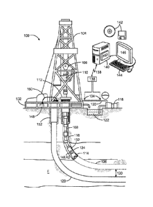
[0015] FIG. 1 depicts an example drilling environment 100 in which
ranging embodiments may be employed. The disclosed apparatus (e.g.,
logging tools), systems, and methods are best understood in the context of
the larger systems in which they operate. Accordingly, FIG. 1 illustrates an
example drilling environment 100 in which a drilling platform 102 supports
a derrick 104 having a traveling block 106 for raising and lowering a drill
string 108. A top drive 110 supports and rotates the drill string 108 as it is
lowered through the well-head 112. A drill bit 114 is driven by a downhole
motor and/or rotation of the drill string 108. As the drill bit 114 rotates,
it
creates a borehole 116 that passes through various formations F. A pump
3
CA 02954668 2017-01-10
WO 2016/025245
PCT/U52015/043621
118 circulates drilling fluid through a feed pipe 120 to top drive 110,
downhole through the interior of drill string 108, through orifices in drill
bit
114, back to the surface via the annulus around drill string 108, and into a
retention pit 122. The drilling fluid transports cuttings from the borehole
into the retention pit 122 and aids in maintaining the borehole integrity.
[0016] The drill bit 114 is just one piece of a bottom-hole assembly
(BHA) that includes one or more drill collars (comprising thick-walled steel
pipe) to provide weight and rigidity to aid the drilling process. Some of
these drill collars include logging instruments to gather measurements of
various drilling parameters such as position, orientation, weight-on-bit,
borehole diameter, etc. The tool orientation may be specified in terms of a
tool face angle (also known as rotational or azimuthal orientation), an
inclination angle (the slope), and a compass direction, each of which can be
derived from measurements made by magnetometers, inclinometers, and/or
accelerometers, though other sensor types such as gyroscopes may also be
used. In one specific embodiment, the tool includes a three-axis fluxgate
magnetometer and a three-axis accelerometer. As is known in the art, the
combination of these two sensor systems enables the measurement of the
tool face angle, inclination angle, and compass direction. In some
embodiments, the tool face and hole inclination angles are calculated from
the accelerometer sensor output, and the magnetometer sensor outputs are
used to calculate the compass direction.
[0017] The BHA further includes a ranging tool 124 to receive signals
from current injected by a power supply 148 into nearby conductors such as
pipes, casing strings, and conductive formations and to collect
measurements of the resulting field to determine distance and direction.
Using measurements of these signals, in combination with the tool
orientation measurements, the driller can, for example, steer the drill bit
114
along a desired path in the drilling well 126 relative to the existing well
(e.g., target well) 128 in formation F using any one of various suitable
directional drilling systems, including steering vanes, a "bent sub", and a
rotary steerable system. For precision steering, the steering vanes may be
the most useful steering mechanism. The steering mechanism can be
controlled from the Earth's surface, or downhole, with a downhole
4
CA 02954668 2017-01-10
WO 2016/025245
PCT/US2015/043621
controller programmed to follow the existing borehole 128 at a
predetermined distance 130 and position (e.g., directly above or below the
existing borehole).
[0018] The ranging tool 124 may comprise one or more elements,
interchangeably designated as receivers or sensors in this document. These
elements may comprise uniaxial, biaxial, or triaxial magnetometers, coil
antennas, and/or telemetry receivers.
[0019] A telemetry sub 132 coupled to the downhole tools (including
ranging tool 124) transmits telemetry data to the surface via mud pulse
telemetry. A transmitter in the telemetry sub 132 modulates a resistance to
drilling fluid flow to generate pressure pulses that propagate along the fluid
stream at the speed of sound to the surface. One or more pressure
transducers 134 convert the pressure signal into electrical signal(s) for a
signal digitizer 136. Note that other forms of telemetry exist and may be
used to communicate signals from downhole to the digitizer. Such telemetry
may include acoustic telemetry, electromagnetic telemetry, or telemetry via
wired drill pipe.
10020] The digitizer 136 supplies a digital form of the telemetry
signals
via a communications link 138 to a computer 140 or some other form of a
data processing device. The computer 140 operates in accordance with
software (which may be stored on non-transitory information storage media
142) and user input provided via an input device 144 to process and decode
the received signals. The resulting telemetry data may be further analyzed
and processed by the computer 140 to generate a display of useful
information on a computer monitor 146 or some other form of a display
device. For example, a driller could employ this system to obtain and
monitor drilling parameters, formation properties, and the path of the
borehole relative to the existing borehole 128 and any detected formation
boundaries. A downlink channel can then be used to transmit steering
commands from the surface to the BHA. In some embodiments, the
computer 140 has analog circuitry installed or is programmed to include a
ranging determination module RD, which operates on the signal data
received down hole at the ranging tool 124 to determine the distance and
direction from the drilling well 126 to the target well 128. The ranging
5
CA 02954668 2017-01-10
WO 2016/025245
PCT/US2015/043621
determination module RD may exist in the computer 140 or the tool 124,
and may be used to implement any of the methods described herein.
[0021] Thus, FIG. 1 illustrates an electromagnetic ranging system with
surface excitation. The power supply 148 at the surface employs a cable 150
to inject current into target well casing 152 and flowing down-hole so that
magnetic fields can be generated surrounding a target well 128. Then
sensors in the ranging tool 124 in the drilling well 126 can determine the
magnetic field strength in various directions so that distance and direction
between the target well 128 and drilling well 126 can be determined. The
power supply 148 can also be connected to inject current into the casing of
the drilling well 126, or be disposed downhole in either the drilling well 126
(shown) or the target well 128 (not shown in this figure).
100221 The drilling well 126 and the target well 128 are often
constructed as a cased hole, with cement installed around the outside of the
casing material (e.g., conductive piping). In the completion phase of oil and
gas wells, the cement serves to isolate the wellbore, helps prevent casing
failure, and keeps the wellbore fluids from contaminating freshwater
aquifers.
[0023] Standard ranging calculations assume an infinite line current
source is provided by the target well, which is not valid when sensors
approach the end of the target well pipe. Indeed, the current source ends
abruptly with the end of the pipe, which dramatically affects ranging results
that depend on the assumption of a constant current source. Moreover,
current leaks into the formation along the length of the target well,
degrading with distance. These environmental conditions create errors in
ranging calculations when the aforementioned current flow assumptions
carry over into the field, and the error increases as the end of the pipe is
approached.
100241 As a solution to this technical problem, and to obtain greater
accuracy, conventional current flow assumptions may be utilized at shallow
depths, and in the near distance (between drilling and target wells).
Measurements are made in these conditions that approach the ideal, where
the target well depth and sensor depth are known, and when the well
6
CA 02954668 2017-01-10
WO 2016/025245
PCT/US2015/043621
separation distance is not large. Thus, range calculations in these locations
can be made using conventional equations.
[0025] However, as the depth and range between wells increase, various
embodiments operate so that the accumulated data can be used to produce a
model of the measurements that match what has been acquired in shallow
depths. This model can be put in place once the received current distribution
along the target well becomes nonlinear (e.g., when the depth is about 200
m to the end of the pipe in the target well). The model includes formation
properties, pipe properties, and distance to the end of the pipe in the target
well, among other components.
[00261 Thus, In the following paragraphs, apparatus, methods, and
systems are described that operate to reduce the end of pipe effect on
ranging performance. End of pipe profiles are modeled, with mathematical
inversion provided to improve ranging measurement performance when
sensors attempt to measure field strength close to the end of a target well,
which acts as a non-uniform current source.
Detailed Presentation
[0027] In surface excitation applications, an excitation current may be
injected into a target well, with sensors located in a drilling well, perhaps
in
the BHA. Thus, sensors are utilized to detect the signals generated by the
target well current and thereafter determine the relative ranging distance and
direction between the target well and the drilling well.
[0028] Conventional ranging calculations are based on the assumption
of a uniform infinite current source. This assumption may be sufficient for
some applications, because the desired ranging distance (e.g., 5-30 m,
depending on the application) is small, compared to the distance that the
excitation current travels in the target well (e.g., more than 500 m). In
other
words, the ranging distance is less than 5% of the distance the excitation
current travels. However, as the ranging sensors approach the end of the
target well, the current in the target well leaks significantly, dropping
precipitously, in a non-linear fashion. Consequently, the assumption of
uniform, infinite current fails near the end of the target well pipe, due to
the
end effect of the pipe in the target well. As a result, ranging distance
7
CA 02954668 2017-01-10
WO 2016/025245 PCT/US2015/043621
determination becomes inaccurate when using conventional ranging
calculations.
[0029] The apparatus, methods, and systems described herein address
the end pipe effect for ranging applications. Ranging planner modeling is
used to consider the end pipe effect and assist in determining the ranging
distance.
[0030] In some embodiments, the ranging planner begins by building a
model in close proximity to the target well, using real target well conditions
based on conventional ranging calculations at shallow depths. Afterward,
the ranging planner operates to update the model that has been built, using
accumulated data and conventional ranging calculations.
[0031] Once the conventional assumptions begin to fail, as determined
via ranging planner modeling and the approach of the end of the target well,
the ranging planner will switch over to using the most recent version of the
model (which can be updated to include the most recent real, acquired data)
to determine the ranging distance, instead of using conventional ranging
calculations. A robust inversion code can be used together with the ranging
planner model to improve ranging distance determination.
[0032] FIGs. 2 to 10 illustrate a variety of apparatus, method, and
system configurations for various range determination embodiments. These
include ranging methods based on the assumption of a uniform, infinite
current source.
[0033] More particularly, FIG. 2 shows an infinite line source with a
constant current I. Based on Ampere's law, the magnetic field II at low
frequency surrounding the line source can be expressed as
- ______________________________________________ (1)
r
where r is the distance between an observation point and the infinite line
source.
[0034] In addition, the gradient field can be given by:
8
CA 02954668 2017-01-10
WO 2016/025245
PCUUS2015/043621
ai
_ _____________________________________ cp 2õir r 2 (2)
100351 Consequently, the distance r can be directly computed by taking
ratio of amplitude of Equation (1) to the amplitude of Equation (2), given by
2 7c r
=r
_
aH ¨ I
(3)
27r r 2
The Ranging planner
[0036] The ranging planner operational processing flow diagram 300 is
shown in FIG. 3. Here it can be seen that the ranging planner 310 utilizes
robust modeling to estimate current distribution along the target well. The
estimate is based on the surface excitation and the corresponding magnetic
field strength around the target well. The ranging planner 310 thus makes
use of several input values 304, including: formation properties (can be
estimated from resistivity logs of offset wells and/or the target well), pipe
properties (can be estimated from pipe vendor datasheets), detailed well
structures (including mud properties, cement properties, and pipe
dimensions), wellbore placement, and other environmental properties (such
as temperature), to enable the modeling simulation.
100371 In practice, some of the input values 304 for the ranging planner
310 may not be accurate or available. Therefore, related modeling responses
may be offset and/or different from real sensor measurements.
Consequently, the conventional ranging calculation shown in Equation (3)
will be used in most embodiments for ranging distance determination at
relatively shallow depths, and the calculated results will be accumulated and
updated for presentation to the ranging planner 310. The ranging planner
310 can use the sensor measurements and calculations provided by Equation
(3) to adjust input parameters (e.g., such as a change in pipe conductivity)
so that a better model can be obtained. The ranging planner 310 will
9
CA 02954668 2017-01-10
WO 2016/025245
PCT/US2015/043621
continue to update the model until the conventional ranging calculation
fails, which typically occurs when sensors approach the end of the target
well. This point is often reached about 200 m from the actual end of the
target well.
[00381 In some embodiments then, the ranging planner is used to
estimate the range at depth, where nonlinear target well current distribution
occurs. For example, FIG. 4 illustrates a model of the target well 400 that
can be used in the ranging planner 310 of HG. 3 to simulate ranging current
responses. With a variety of input parameters defined in FIG. 4, the ranging
planner model can thus operate to simulate the current distribution in the
target well 400.
[00391 The modeling response provided by the ranging planner is
shown in the graph 500 of FIG. 5. here the response 510 represents the
normalized current distribution along the target well, according to the
parameters shown for the model of the target well 400 in FIG. 4. The
normalized current distribution, as the response 510, is the ratio of the
calculated current at each depth to the surface current at the wellhead of the
target well.
[00401 As can be seen in FIG. 5, the current distribution response 510
is
substantially linear before a measured depth of 940 m. However, after about
940 m, the injected current degrades, due to the end of pipe effect, so that
nonlinear current distribution is observed. At this depth (roughly 950 m ¨
1000 m), the conventional ranging calculation shown in Equation (3)
becomes inaccurate. Thus, at this point, instead of relying on conventional
current distribution assumptions, the ranging planner operates to provide
modeling responses of the magnetic field surrounding the target well, based
on the given model.
[0041] Table I shows an example of the modeling field responses
surrounding the target well 400 of FIG. 4, at three different measured depths
and three different ranging distances. The field responses, as a magnetic
field strength, are normalized by the current amplitude of the surface
excitation, which can be measured at the surface from the power supply
system. Using the modeling capabilities of the ranging planner, the ranging
distance can be directly determined by comparing the sensor measurements
CA 02954668 2017-01-10
WO 2016/025245
PCT/US2015/043621
with the modeling responses in Table I. A robust inversion method or a
linear interpolation method can then be used to determine the ranging
distance that produces the modeling responses matching the sensor
measurements at a specific depth.
Measured Distance Corresponding
Depth (m) between sensor magnetic field
and target well strength (A/m)
(m) normalized by
surface current
(A)
799.9283 5 7.594115E-04
799.9283 5.05 7.519060E-04
799.9283 5.1 7.445478E-04
810_9079 5 7.140296E-04
810.9079 5.05 7.069728E-04
810.9079 5.1 7.000545E-04
-820.667 5 6.745488E-04
-820.667 5.05 6.678824E-04
-820.667 5.1 6.613468E-04
Table I
1[00421 FIG. 6 is a flow diagram for some of the processing methods
proposed herein, including a ranging planner algorithm 600. Thus, before
operating the tool downhole for ranging applications, some pre-existing
(i.e., known) information can be provided by the field operator as input
parameters to the algorithm executed by the ranging planner (refer to the
ranging planner 310 in FIG. 3). If measurement information is not available,
the best estimate can be entered. Afterward, during operation, the ranging
sensors will be used to take measurements at different depths downhole.
The information obtained by the ranging sensors can then be used to
calculate the ranging distance using Equation (3).
I00431 Using the ranging planner algorithm 600, one can determine
when the sensors are approaching the end of the target well, or some depth
where nonlinear current distribution occurs in the target well. Thus, if
Equation (3) is still valid based on the solutions provided by the ranging
planner 610, then the ranging solutions (including ranging distance, current
11
CA 02954668 2017-01-10
WO 2016/025245
PCT/US2015/043621
distribution of the target well, and the currently-built model) will be made
available to the field operator. However, if Equation (3) is no longer valid
due to the sensors encountering the end of pipe effect (i.e., the field
strength
measured by the sensors indicates that the actual current distribution has
become non-linear), the ranging planner 610 will operate to use an inversion
with all accumulated measurements and valid calculations. The inversion
will operate to adjust the input parameters to create a model with modeling
responses that match the actual measurements.
[0044] Once the model is defined, on the basis of the accumulated
measurements and calculations, the inversion will be used to calculate the
corresponding ranging distance, similar to what has been shown in the
modeling data in Table I. The best lit between sensor field measurements
and modeling output data will then be used to determine the actual ranging
distance between the sensors and the target well.
[0045] At this point, the ranging solutions will be provided as output
from the inversion activity. In some embodiments, the inversion activity
begins prior to indications of non-linearity, at a shallow depth. The
inversion result may be easier to calculate than near the end of pipe/casing,
but the inversion calculation will likely take longer than using the
conventional ranging calculations of Equation (3).
[0046] In applications with EM signals traveling within a pipe, it is
useful to estimate the signal strength of the signals at different positions
along the pipe. The signal strength may vary due to different formation
properties, different casing sizes and configurations, etcetera, such that
receiving sensors may not be effective to determine the signal source
location downhole. Therefore, the ranging planner may help operators
estimate the signal attenuation in the pipe by modeling the expected field
conditions before the actual job is conducted. However, available modeling
codes providing a reasonable simulation speed do not consider formation
layering in addition to pipe bend effects and completions with multiple pipe
sections. Three-dimensional (3D) modeling software can provide this
additional information, but is often too slow to render a practical solution
for commercial operations, and sometimes fails to render any solution at all
(e.g., the solver fails to converge).
12
CA 02954668 2017-01-10
WO 2016/025245
PCT/US2015/043621
[0047] To solve this technical problem, a methodology has been
developed to simulate a well with a complex pipe structure, by simplifying
the structure so that it can be represented by a solid pipe with an effective
pipe cross section. The solid pipe can then be treated as a thin wire with
behavior that can be analyzed relatively quickly with integral methods. This
technique can be used in many applications, such as magnetic ranging and
EM telemetry, to help to predict the current flow along the casing, and
signal levels at designated receivers. This technique can be also used in
vertical or deviated wellbores.
[0048] A ranging planner that utilizes this technique may provide the
following capabilities: (a) accurately devising a ranging plan (e.g., what
type of source should be used at various depths); (b) updating the ranging
plan as the well is drilled and new information is acquired; and (c)
measuring the distance to the target well, even near the end of the well, by
using a calibrated absolute signal.
[0049] In well drilling and logging system design, it is often useful
to
have an estimation of system performance as provided by analytical or
numerical modeling. For example, in EM telemetry system design, it is
useful to have an idea of the estimated signal level that can be received at
the surface based on the tool and environment parameters. Excitation energy
can thus be selected, based on the estimate provided. Transmitter, receiver,
and repeaters can also be designed and placed, as well as operated, based on
the estimate. In another example, it is useful to ensure sure there is enough
current flow down-hole in the target well for ranging applications, to
generate a signal with sufficient strength that sensors in the drilling well
can
reliability detect it. Hence, an estimation of the current distribution along
a
drilling tool can be useful for designers to predict the feasibility of the
system to be chosen, and to select the input power of the source at the
surface. A ranging planner with fast modeling capability, as described
herein, can be used to predict the signal or current level in real time, as
well
as in pre-job simulation applications, such as modeling EM telemetry and
magnetic ranging system performance.
[0050] In an EM telemetry or magnetic ranging system, the borehole
and drilling tool usually form a complex profile 700 along the radial
13
CA 02954668 2017-01-10
WO 2016/025245
PCT/US2015/043621
direction, as shown in FIG. 7. Here, the profile 700 includes multiple
casings and multiple cement applications, together with tubing and mud. In
order to accurately estimate current flow for a down hole magnetic ranging
system that operates in this environment, or predict the received signal level
at the surface in an EM telemetry system, it is desirable to model the
drilling
tool with as many tool and environmental parameters as possible (e.g., tube,
mud, cement). As mentioned previously, 3D modeling is time consuming.
Two-dimensional (2D) modeling may be useful for some wells, when
azimuthal symmetry is involved, but 2D modeling is not applicable to
deviated wells.
[0051] In FIG.7, an approximation 710 of the complex pipe profile is
provided, in the modeled form of a solid pipe with an effective cross
section. Thus, the methodology proposed herein can operate to provide an
approximation 710: the complex tool is modeled as a simple solid pipe with
the same resistance per unit length. This assumes that the most prominent
factor affecting the current flow and field distribution on/around the
drilling
string is the resistance per unit length of the pipe. With an estimated
resistance per unit length for complicated well structures, the simplified
solid pipe model can provide current and field distribution estimates that are
quite close to the original complex tool model.
[0052] The simplified model (e.g., the solid pipe with an effective
cross
section) can then be treated as a thin wire, and analyzed with fast one-
dimensional method of moments (MOM) simulation code, which is
applicable to both vertical and deviated wells. This can be accomplished by
dividing the task into three activities: obtain the resistance per unit length
for the original tool structure, derive the effective cross section radius and
effective conductivity, and analyze the solid pipe model to obtain the
current/ field distribution. Each of these activities will now be described in
detail.
[0053] To begin, the resistance per unit length for the original tool
structure is obtained. FIG. 8 shows a perspective view of a length of pipe
800 (e.g., a drill string), which is assumed to exist as a cylindrical
structure
that is infinitely long in the axial direction. Analytic solutions for pipe
resistance exist for some simple cases, but the finite-difference, time-
14
CA 02954668 2017-01-10
WO 2016/025245
PCT/US2015/043621
domain (FDTD) method is employed here to provide a solution for more
complicated radial geometries. The structure of the pipe 800 has both X-Y
plane symmetry and azimuthal symmetry, so that the resistance problem can
be solved using a one-dimensional method.
[0054] As shown in FIG. 9, the pipe 800 is discretized into concentric
cylinders, or FDTD grid elements 910, and the magnetic and electric fields
at each discrete point are solved. With these field values, the effective
resistance per unit length of the complex model can be obtained. Referring
now to FIGs. 8 and 9, it can be seen that a constant current with the value of
/0 is assumed to be flowing through the pipe 800. Then, if the potential
difference V on a portion of the pipe 800 with length Al is found, the
V
¨
resistance for the pipe section L_MAl is: R =. Hence the resistance per
V
unit length of the pipe is Rtool = I A/ = z . With the
voltage
0 0
on the portion of the pipe Ez calculated using the FDTD process, the
resistance per unit length of the pipe Rtool can be obtained.
[0055] FIG. 10 illustrations the approximation of the original tool
with
an equivalent solid pipe. Thus, at this point, the effective cross section
radius re and effective conductivity cre are derived to achieve the same
resistance per unit length R
tool(n/ in) for the solid pipe model. To
obtain the equivalent solid pipe model with same resistance per unit length,
an arbitrary conductivity s for the solid pipe is chosen.
1 ,r,
[0056] The resistivity of the solid pipe is Rs k " = in). The cross
cre
section of the solid pipe can be derived as
CA 02954668 2017-01-10
WO 2016/025245
PCT/US2015/043621
1
Ae ¨ Rs (m2 ) =
, such that the effective radius of the
Cre R tool
R tool
r¨
Ae 1
--- ¨
solid pipe is then determined as e z ¨
'ti'rue Rtool
[0057] The accuracy of this approximation depends on the relative
relationship between the metal skin depth as and the solid pipe effective
radius re . When aS >> re , the accuracy improves, so that the entire
solid pipe cross section has current flow. If only part of the cross section
has
current flow when Os is smaller than re , the accuracy of the
approximation is reduced.
[0058] The metal skin depth of the equivalent solid pipe is
6 = .112
Arrepolur f . Since the permeability of the pipe does not
change the effective radius, the permeability Pr is chosen to maximize the
metal skin depth of the solid pipe model. Since ranging and EM telemetry
usually operate at very low frequencies (e.g., on the order of 10 Hz), the
corresponding metal skin depth tends to satisfy the condition Os >> re,
so that the approximation used herein provides an accuracy that is more than
sufficient for field work at useful operating frequencies. If a higher
operating frequency is desired, the accuracy of the approximation may be
reduced. However, reasonable results can often he achieved at operating
frequencies up to 100 Hz.
[0059] FIGs. 11 to 12 illustrate thin wire modeling of solid pipe
according to various embodiments. Here the solid pipe model is analyzed to
obtain a current/ field distribution, by treating it as a thin wire that is
modeled using a one-dimensional MOM algorithm. In this algorithm, the
wire is modeled as dipole sections TM Tm.Nthat are embedded in a
conducting half-space (e.g., a geological formation). An isolation gap with
16
CA 02954668 2017-01-10
WO 2016/025245
PCT/US2015/043621
signals applied to the ends of the gap, perhaps using E-field excitation, is
modeled as the transmitter.
[0060] The transmitter can be placed at the surface of the Earth, as
shown in FIG. 11. and connected with the wellhead to model surface
excitation for magnetic ranging applications. The current distribution along
the target well casing is calculated and the down-hole current level can be
estimated for ranging to a second drilling well. The transmitter can also be
placed down-hole near the drill bit, as shown in FIG. 12, to model an
electrode in an EM telemetry system.
[0061] In either case, the voltage at the surface is calculated and the
predicted signal level can be used in making system design decisions. By
using Green's function for a two layer medium with dipole radiation in the
presence of a conducting half-space, the integral equation for the E-field
generated by the pipe can be developed. The integral equation array for the
E-field at all dipole sections can be discretized into a matrix equation and
solved by the MOM algorithm. The current distribution along the drill pipe
or the fl-field (e.g., voltage) at the surface can then be calculated.
[0062] In order to test the model and verify the accuracy of the
approximation method described herein, a straight pipe with different pipe
structures (with/without mud and cement) was taken as an example. The
basic structure of the model can be seen by referring back to FIG. 4.
[0063] In this case, a voltage source was placed at the surface between
the wellhead and a ground stake 100 m away (instead of 250m away, as
shown in FIG. 4). All other pipe dimensions and material parameters are the
same as shown in FIG. 4. The current distribution along the casing was
calculated to predict the down hole current level for a magnetic ranging
application. The original pipe was modeled using commercial software
available from Computer Simulation Technology AG (CST), with its
headquarters in Darmstadt, Germany. The CST software simulation results
were compared with the MOM results for an equivalent solid pipe, and the
outcome of the comparison will now be discussed.
[0064] FIGs. 13 to 16 are graphs 1300, 1400, 1500, 1600 comparing
simulations and approximations according to various embodiments. As can
be seen from the comparison results in these figures, the approximation
17
CA 02954668 2017-01-10
WO 2016/025245
PCT/US2015/043621
results provided by the methods described herein (dashed lines) are in
agreement with the CST 3D full-wave simulation results (solid lines). This
is so, even when the values of steel conductivity a vary by more than 2:1
and the values of relative permeability II, vary by 100:1 (as between graphs
1300 and 1400), and whether or not cement is present (as between graphs
1500 and 1600). The approximation method can thus achieve accuracy
similar to a complete simulation, but in far less time. For example, the
approximation algorithm took only a few seconds to simulate equivalent
solid pipe activity, while the CST software simulation took about a half an
hour, running on the same computer. Thus, the approximation method
described herein greatly improves modeling and prediction efficiency, as
well as the operation of the computer itself.
[0065] In many applications, the pipe profile along the measured depth
(MD) may vary due to different layers of casings and changes in the casing
materials. The approximation method can accommodate this type of
inhomogeneous pipe profile by modeling the profile as a solid pipe with
varying conductivities along the measured depth.
[0066] This is shown in FIGs. 17 to 18, which illustrate pipe
conversion
modeling according to various embodiments. In FIG. 17, a pipe structure
profile 1700 with multiple casings is shown. Three different pipe profile
sections 1710, 1720, 1730 along the MD are present, using multiple casings
and connectors. To model this pipe structure profile 1700, each section i
(for I = 1 to 3) along the MD is analyzed with finite-difference (FD)
method to obtain the resistance per unit length Rt00i (i) . An arbitrary
Cie =II is chosen for the first section 1710, and the effective radius re
is determined. The same value of c for the other sections 1720, 1730 is
maintained, and the value of a. e(t) for other sections 1720, 1730 is
calculated. In this way, a solid pipe model with constant radius and varying
conductivity along the measured depth is obtained as the approximation
1740.
18
CA 02954668 2017-01-10
WO 2016/025245
PCT/US2015/043621
[0067] For the MOM analysis of the solid pipe model approximation
1740, instead of defining a constant conductivity for the pipe, a conductivity
array reflecting the variations in the pipe profile 1700 is defined. Each
discretized pipe element (e.g., the sections 1710, 1720, 1730) will then have
one conductivity value. The conductivity array is incorporated into the
matrix equation and solved using the MOM method.
[0068] This method of approximation can be extended to include
formations having a radial variation. In that case, for each vertical layer, a
formation with zones of radial variation can be treated as part of the tool,
and included in the FDTD model as shown in FIG. 18, which illustrates
converting the original tool profile 1800, including the surrounding
formation into a solid pipe model approximation 1810. This is so, even
when the formation has radial variations (e.g., divided into Formation 1,
Formation 2, Formation 3, Formation 4, and Formation 5 in the figure,
according to conductivity), with an inhomogeneous pipe profile along the
MD. The calculated resistance per unit length is then used to derive an
equivalent solid cylinder radius in the approximation 1810 in the same way
as described previously. For an inhomogeneous pipe profile along the MD
(e.g., a pipe having a vertical variation), the effective resistance per unit
length can be obtained for each vertical layer as shown in FIG. 18, which is
similar to that shown and described for FIG. 17.
[0069] By including formation zones of radial and vertical variation in
the pipe model approximation 1810, the original inhomogeneous formation
problem is converted into a homogeneous formation problem. Hence, the
MOM method described above can be used to solve the solid pipe model
approximation 1810. A complicated multi-region, Green's function solution
is therefore not needed to improve the MOM method when modeling an
inhomogeneous medium.
[0070] FIGs. 19 to 23 illustrate a variety of methods 1900, 2000, 2100,
2200, 2300, according to various embodiments. When incorporated into the
ranging planner modeling scheme, the methods described permit quickly
estimating the signal strength surrounding a pipe, without the use of detailed
well structures and complicated inhomogeneous formation models. The
accuracy of the methods may be reduced when deviated/bent well structures
19
CA 02954668 2017-01-10
WO 2016/025245
PCT/US2015/043621
exist, but even so, relatively good estimates for signal strength can be
provided ¨ in real time. This allows an operator to understand surface
excitation performance for magnetic ranging, and communication
performance for EM telemetry application as they are applied in the field.
[0071] One embodiment of the ranging planner processing method is
presented in the flow diagram 1900 of FIG. 19. In this case, the method can
be integrated with ranging planner software instruction execution, where
excitation performance can be simulated prior to running a particular field
job with input values comprising formation profiles (which can be estimated
from resistivity logs of offset wells and/or the target well), pipe properties
(which can be estimated from pipe vendor datasheet), detailed well
structures (including mud, cement, and pipe dimensions), wellbore
placement, and other properties (e.g., environmental temperature and
desired signal strength).
[0072] As can be seen in the processing flow diagram 2000 of FIG. 20,
in another embodiment of a ranging planner processing method, ranging
planner operation can provide improved well placement. In this case, the
method 2000 can be executed to determine whether the desired signal
strength can be obtained for a particular well before the well is drilled and
completed
[0073] Here, known parameter values are entered, including formation
properties, pipe properties, pipe total length, mud and cement rcsistivities,
etc. Then, the wellbore placement path, wellbore true vertical depth (TVF)),
and wellbore measured depth are inverted based on the desired single
strength.
[0074] For example, referring now to FIG. 21, it can be seen that the
left-hand side of the figure might represent the original wellbore placement
for a particular field job. However, due to the existence of conductive
formations at certain depths, the signal strength may drop significantly if
the
wellbore is permitted to penetrate such layers. Consequently, the ranging
planner can utilize the proposed fast modeling computation described herein
to roughly estimate the signal strength for different drilling paths in the
formations, even when radial variations are expected, to provide an
improved well placement that delivers the desired signal strength.
CA 02954668 2017-01-10
WO 2016/025245
PCT/US2015/043621
[0075] The right-hand side of FIG. 21 shows an improved wellbore
placement that meets the desired signal performance. It is noted that
inversion and fast modeling in the ranging planner can be performed prior to
and/or during each field job; that is, the ranging planner can be used for pre-
job modeling and/or real-time modeling applications, so that drilling
adjustments can be made in real time, as measurements are made and
processed according to the various methods described herein.
100761 For real-time modeling, the proposed methods can be calibrated
based on real-time measurements, such that input properties can be better
adjusted to match with field measurements, with more accurate estimation
results. Thus, ranging planner simulation modeling can be calibrated using
real-time measurements as shown in the real-time calibration scheme 2200
of FIG. 22. For example, the ranging planner can be operated to provide
pre-job modeling based on the best knowledge (or estimate) of all properties
to obtain a rough prediction of signal strength as shown by the pre-job
modeling solid line in the figure. Then, the ranging planner can utilize
downhole sensors measurements in real-time, as shown by the dotted line in
the figure, to compare with the pre-job modeling results.
[0077] If the properties entered and used to run the pre-job modeling
are
reasonably accurate, the pre-job modeling results (solid line) should match
the measurements (dotted line) made in the field. However, the down hole
environment parameters may change over time or distance, and thus, a
difference between the modeling results and field measurements may be
observed, as seen in the figure. When this occurs, as shown in FIG. 22, the
ranging planner can operate to model the underground signal strength by
adjusting property values within reasonable ranges to match the field
measurements, so that over subsequent measuring cycles (e.g., second
calibrated modeling dot-dash line and Nth calibrated modeling dashed line
in the figure), the modeled signal strength values will more closely follow
actual measurements.
[0078] Finally, the ranging planner can operate to predict the
underground signal strength for the remainder of the well based on the
adjusted property values. Real-time calibration is thus possible, and can be
performed multiple times due to the rapid simulation capability described
21
CA 02954668 2017-01-10
WO 2016/025245
PCT/US2015/043621
herein. The result is additional impiovement for estimates of the
underground signal strength.
[0079] The ranging planner apparatus, methods, and systems can thus
be used to obtain reliable estimates of ranging excitation or telemetry signal
strength, prior to conducting field operations. Embodiments of the ranging
planner can also operate to update environmental parameters in real-time,
based on data acquired in the field, to give operators an indication as to
when unexpected situations might develop, and a better idea of the signal
strength to be expected as drilling continues to greater depths. Other method
embodiments may be realized.
[0080] For example, FIG. 23 illustrates a method 2300 of measurement
and adjustment according to various embodiments. At block 2321, the
method 2300 comprises measuring a total electromagnetic field value, and a
field gradient, as a set of measurements along an initial portion of a
drilling
well, of an electromagnetic field originating at a target well due to direct
transmission or backscattcr transmission
[0081] At block 2325, the method 2300 comprises determining an
approximate range between the drilling well and the target well using field
equations (e.g., Equation (3) and the set of measurements). At block 2329,
the method 2300 comprises repeating the measuring and determining at
blocks 2321 and 2325 at increasing depths along the drilling well to build a
model of current distribution along the target well, using the set of
measurements obtained during each instance of the measuring (while the
current distribution remains linear, as determined at block 2333).
[0082] At block 2333, when a comparison of a measurement predicted
by the model to at least one component in the set of measurements indicates
nonlinearity in the current distribution (i.e., the end of pipe effect is
prominent, perhaps determined by comparing model results to the results of
field calculations at block 2325, to determine whether the difference
between the modeled results and the field calculations exceeds a selected
threshold), the method 2300 operates to switch from using the conventional
calculations at block 2325, which are now considered to be unreliable, to
using the model to determine the range.
22
CA 02954668 2017-01-10
WO 2016/025245
PCT/US2015/043621
[0083] This part of the method 2300 comprises continued measurement
of the total electromagnetic field value and the field gradient at block 2337,
and then inverting the approximate range to determine a model response
that matches the set of measurements at block 2341. After inversion, the
model response (i.e., inverted range) is used in place of at least one
component in the set of measurements to determine an actual range, as a
substitute for the approximate range, which would have been calculated as
part of the method 2300 that includes block 2325.
[0084] At blocks 2345 and 2349, the method 2300 is shown to include
continuing the measuring and the inverting at blocks 2337 and 2341,
respectively, until the increasing depths reach an end of casing material in
the drilling well. The method 2300 then terminates at block 2349.
Additional Detailed Description and Some Representative
Embodiments
[0085] FIG. 24 is a block diagram of a wireline system 2400
implementation of various embodiments. The system 2400 of FIG. 24 may
include any of the embodiments of receiver or sensor mounting discussed
previously. In this case, a hoist 2406 may be included as a portion of a
platform 2402, such as coupled to a derrick 2404, and used to raise or lower
equipment such as a wireline sonde 2410 into or out of a borehole. The
wireline sonde 2410 may include any one or more of the above-described
embodiments, including sensors and a range determination module RD.
[0086] In this wireline example, a cable 2442 may provide a
communicative coupling between a logging facility 2444 (e.g., including a
processor circuit 2445 including memory or other storage or control
circuitry) and the sonde 2410. In this manner, information about the
formation 2418 may be obtained. The processor circuit 2445 can be
configured to access and execute instructions stored in a memory to
implement any of the methods described herein (e.g., by accessing a range
determination module RD).
[0087] FIG. 25 is a block diagram of a drilling system 2500
implementation of various embodiments. This diagram shows a drilling rig
system 2500 according to various embodiments that may include
measurement while drilling (MWD) or logging while drilling (LWD)
23
capability. The drilling apparatus can use data from an insert in the drill
string 2508, having attached to a number of receivers or sensors as
discussed previously, and using acquired and calculated ranging information
to steer the drill bit 2514.
[0088] A drilling rig or platform 2402 generally includes a derrick 2404
or other supporting structure, such as including or coupled to a hoist 2406.
The hoist 2406 may be used for raising or lowering equipment or other
apparatus such as drill string 2508. The drill string 2508 may access a
borehole 2516, such as through a well head 2512. The lower end of the drill
string 2508 may include various apparatus, such as a drill bit 2514, such as
to provide the borehole 2516.
[0089] A drilling fluid or "mud" may be circulated in the annular
region
around the drill bit 2514 or elsewhere, such as provided to the borehole
2516 through a supply pipe 2522, circulated by a pump 2520, and returning
to the surface to be captured in a retention pit 2524 or sump. Various subs or
tool assemblies may be located along the drill string 2508, such as a bottom
hole assembly (BHA) 2526 or a second sub 2528. The BHA 2526 and/or the
sub 2528 may include one or more sensors or receivers, as described herein,
along with a current source (e.g., power supply 148) to initiate a ranging
signal, and a processor with access to a memory that contains a program to
implement any of the methods described herein (e.g., a ranging
determination module RD).
[0090] Thus, some of the embodiments described herein may be
realized in part, as a set of instructions on a computer readable medium 142
comprising ROM, RAM, CD, DVD, hard drive, flash memory device, or
any other computer readable medium, now known or unknown, that when
executed causes a computing system, such as computer as illustrated in FIG.
1 or some other form of a data processing device 140, to implement portions
of a method of the present disclosure, for example the processes and
methods described in FIGs. 3, 6-7, 9-12, and 17-23 (e.g., for computer-
assisted well completion).
[0091] Though sometimes described serially in the examples of FIGs. 3,
6-7, 9-12, and 17-23, one of ordinary skill in the art would recognize that
other examples may reorder the operations, omit one or more operations,
24
CA 2954668 2018-04-12
CA 02954668 2017-01-10
WO 2016/025245
PCT/US2015/043621
and/or execute two or more operations in parallel using multiple processors
or a single processor organized as two or more virtual machines or sub-
processors. Moreover, still other examples can implement the operations as
one or more specific interconnected hardware or integrated circuit modules
with related control and data signals communicated between and through
the modules. Thus, any process flow is applicable to software, firmware,
hardware, and hybrid implementations.
[0092] It is expected that the system range and performance can be
extended with the various embodiments described herein. Power can often
be saved, and accuracy of ranging measurements improved. Signal
components may be extracted and converted to pixel colors or intensities
and displayed as a function of tool position and azimuth. Assuming the
target casing string is within detection range, it may appear as a bright (or,
if
preferred, a dark) bard in the image. The color or brightness of the band
may indicate the distance to the casing string, and the position of the band
indicates the direction to the casing string. Thus, by viewing such an image,
a driller can determine in a very intuitive manner whether the new borehole
is drifting from the desired course and he or she can quickly initiate
corrective action. For example, if the band becomes dimmer, the driller can
steer towards the casing string. Conversely, if the band increases in
brightness, the driller can steer away from the casing string. If the band
deviates from its desired position directly above or below the casing string,
the driller can steer laterally to re-establish the desired directional
relationship between the boreholes.
100931 While the text of this document has been divided into sections, it
should be understood that this has been done as a matter of convenience,
and that the embodiments discussed in any one section may form a part of
any or more embodiments described in another section, and vice-versa.
Moreover, various embodiments described herein may be combined with
each other, without limitation. Thus, many embodiments may be realized.
Some of these will now be listed in a non-limiting fashion.
[0094] In some embodiments, a method of range determination
comprises measuring a total electromagnetic field value, and a field
gradient, as a set of measurements along an initial portion of a drilling
well,
CA 02954668 2017-01-10
WO 2016/025245
PCT/US2015/043621
of an electromagnetic field originating at a target well due to direct
transmission or backscatter transmission. The method may further comprise
determining an approximate range between the drilling well and the target
well using field equations and the set of measurements; repeating the
measuring and determining at increasing depths along the drilling well to
build a model of current distribution along the target well, using the set of
measurements obtained during each instance of the measuring; and when a
comparison of a measurement predicted by the model to at least one
component in the set of measurements indicates nonlinearity in the current
distribution, inverting the approximate range to determine a model response
that matches the set of measurements, using the model response in place of
at least one component in the set of measurements to determine an actual
range to substitute for the approximate range.
[0095] In some embodiments, the method comprises continuing the
measuring and the inverting until the increasing depths reach an end of
casing material in the drilling well.
[0096] In some embodiments, the method comprises determining that
the comparison indicates nonlinearity when a selected threshold is
exceeded.
[0097] In some embodiments, the method comprises continuing the
measuring when the comparison does not indicate nonlinearity.
100981 In some embodiments, the at least one component comprises one
or more of a total field measurement or a gradient field measurement. In
some embodiments, the current distribution comprises a normalized current
distribution along the target well, as a ratio of calculated current at each
of
the depths to surface current at a wellhead of the t et well.
[0099] In some embodiments, building the model of the current
distribution comprises modeling the target well using a solid pipe
approximation. In some embodiments, building the model of the current
distribution comprises modeling the target well using a thin wire
approximation. In some embodiments, building the model of the current
distribution comprises modeling a formation surrounding the target well and
the target well using a solid pipe approximation.
26
[0100] In some embodiments, the method comprises estimating signal
strength associated with the electromagnetic field surrounding the solid pipe
in
real time, as an indication of surface excitation performance for magnetic
ranging and/or communication performance for electromagnetic telemetry.
[0101] In some embodiments, using the model response to determine the
actual range comprises calculating the actual range determined by a fit
between
sensor field measurements and modeling output data.
[0102] In some embodiments, the model comprises initiating the
inverting as
inversion activity prior to determining existence of the nonlinearity.
[0103] In some embodiments, the model comprises calibrating a modeled
version of signal strength associated with the electromagnetic field by
adjusting
down hole environment parameters to provide adjusted parameters so that the
modeled version matches the set of measurements.
[0104] In some embodiments, the model comprises predicting the signal
strength along a remainder of the drilling well based on the adjusted
parameters.
[0105] In some embodiments, as shown in FIGs. 1, 24, and 25, an
apparatus
comprises a down hole tool housing attached to a set of sensors, the down hole
tool housing comprising one or more of a bottom hole assembly, a drill collar,
a
drill string pipe, or a sub. The apparatus may further comprise a processor
(e.g.,
computer 140 or range determination module RD) communicatively coupled to
the set of sensors to receive electromagnetic signal strength signals as a set
of
measurements from the sensors, and to a memory. The memory may include a
set of instructions which, when executed by the processor, cause the processor
to
implement a method comprising determining an approximate range between a
drilling well and a target well using field equations and the set of
measurements,
repeatedly receiving the signals and determining the approximate range at
increasing depths along the drilling well to build a model of current
distribution
along the target well, and when a comparison of a measurement predicted by the
model to at least one component in the set of measurements indicates
nonlinearity in the current distribution, inverting the approximate range to
determine a model response that matches the set of measurements, using the
model response in place of at least one component in the set of measurements
to
determine an actual range to substitute for the approximate range.
27
CA 2954668 2018-04-12
CA 02954668 2017-01-10
WO 2016/025245
PCT/US2015/043621
[0106] Thus, in some embodiments, the processor comprises a ranging
determination module RD disposed in the down hole tool housing. In some
embodiments, the processor comprises a ranging determination module RD
disposed in a surface computer.
[0107] In some embodiments, as shown in FIG. 1, a system comprises a
source of current or voltage (e.g., a power supply 148) to electrically couple
to a
well casing of a first well or to attach to a first down hole tool housing.
The
system may further comprise a drill string to be disposed in a second well and
mechanically coupled to a second down hole tool housing, the second down hole
tool housing attached to a set of sensors. The system may also comprise a
processor communicatively coupled to the set of sensors to receive signals
representing electromagnetic field strength from the sensors, in response to
the
source exciting the well casing directly to initiate direct signal
transmission, or
indirectly via backscatter transmission, the processor communicatively coupled
to a memory having a set of instructions which, when executed by the
processor,
cause the processor to implement a method comprising determining an
approximate range between a drilling well and a target well using field
equations
and the set of measurements, repeatedly receiving the signals and determining
the approximate range at increasing depths along the drilling well to build a
model of current distribution along the target well, and when a comparison of
a
measurement predicted by the model to at least one component in the set of
measurements indicates nonlinearity in the current distribution, inverting the
approximate range to determine a model response that matches the set of
measurements, using the model response in place of at least one component in
the set of measurements to determine an actual range to substitute for the
approximate range.
[0108] In some embodiments of the system, the source of current or
voltage
(e.g., a power supply 148) is coupled to the well casing of the first well via
a
well head of the first well. In some embodiments of the system, the source of
current or voltage is attached to the first down hole tool housing near a
drill bit.
[0109] In some embodiments, an apparatus comprises a down hole tool
housing (e.g., ranging tool 124) attached to a set of sensors, the down hole
tool
housing comprising one or more of a wireline sonde, a bottom hole assembly, a
drill collar, a drill string pipe, or a sub. Some embodiments of this
apparatus
28
further comprise a processor (e.g., computer 140) communicatively coupled to
the set of sensors to receive electromagnetic signal strength signals from the
sensors, and to a memory (e.g., medium 142), the memory having a set of
instructions which, when executed by the processor, cause the processor to
implement any of the methods described herein.
[0110] In some embodiments, a system comprises a source of current or
voltage (e.g., power supply 148) to electrically couple to a well casing of a
first
well or to attach to a first down hole tool housing. Some embodiments of this
system further comprise a drill string to be disposed in a second well and
mechanically coupled to a second down hole tool housing, the second down hole
tool housing attached to a set of sensors. Some embodiments of this system
further comprise a processor (e.g., computer 140) communicatively coupled to
the set of sensors to receive signals representing electromagnetic field
strength
from the sensors, in response to the source exciting the well casing directly
to
initiate direct signal transmission, or indirectly via backscatter
transmission, the
processor communicatively coupled to a memory (e.g., medium 142) having a
set of instructions which, when executed by the processor, cause the processor
to
implement any of the methods described herein.
[0111] Numerous other variations and modifications will become
apparent to
those skilled in the art once the above disclosure is fully appreciated. For
example, the foregoing discussion has focused on a logging while drilling
implementation, but the disclosed techniques would also be suitable for
wireline
tool implementation (as shown in FIG. 24).
101121 In this description, references to "one embodiment" or "an
embodiment," or to "one example" or "an example" mean that the feature being
referred to is, or may be, included in at least one embodiment or example of
the
invention. Separate references to "an embodiment" or "one embodiment" or to
"one example" or "an example" in this description are not intended to
necessarily refer to the same embodiment or example; however, neither are such
embodiments mutually exclusive, unless so stated or as will be readily
apparent
to those of ordinary skill in the art having the benefit of the knowledge
provided
by this disclosure. Thus, the present disclosure includes a variety of
combinations and/or integrations of the embodiments and examples described
herein, as well as further embodiments and examples, as defined by the claims.
29
CA 2954668 2018-04-12
10113] The accompanying drawings that form a part hereof, show by way
of
illustration, and not of limitation, specific embodiments in which the subject
matter may be practiced. The embodiments illustrated are described in
sufficient
detail to enable those skilled in the art to practice the teachings disclosed
herein.
Other embodiments may be used and derived therefrom, such that structural and
logical substitutions and changes may be made without departing from the scope
of this disclosure. This Detailed Description, therefore, is not to be taken
in a
limiting sense.
CA 2954668 2018-04-12