Note: Descriptions are shown in the official language in which they were submitted.
CA 02956205 2017-01-24
WO 2015/200489 PCT/US2015/037435
AGRONOMIC SYSTEMS, METHODS AND APPARATUSES
RELATED APPLICATIONS
[001] The present application claims the priority benefit of co-pending U.S.
Provisional Patent
Application Nos. 62/016,624, filed June 24, 2014, and 62/054,870, filed
September 24, 2014,
the contents of all of which are incorporated by reference herein in their
entirety.
FIELD OF THE INVENTION
[002] The present disclosure relates generally to agronomics and, more
particularly, to
agronomic systems, methods and apparatuses.
BACKGROUND
[003] Today, the most common farming practice includes planting identical
plant variety and
consistent plant population across an entire field and applying inputs, such
as fertilizers,
herbicides, insecticides, etc., to the entire field at a constant rate. These
conventional practices
are performed with a belief that a uniform plant variety, uniform plant
population, and/or
uniform rate of input application over the entire field will maximize crop
yield. Unfortunately,
these conventional practices result in maximizing crop yield much less than
they succeed.
Many reasons exist that cause these conventional practices to fail such as,
for example,
inconsistent soil types and conditions, inconsistent crop conditions,
inconsistent weather
patterns, inconsistent soil slopes, etc. Thus, many inconsistencies exist
across an entire field
that impact the growth of a crop. These conventional practices may also result
in wasted
money, actually reduce crop yield, and potentially damage the environment
through over
1
CA 02956205 2017-01-24
WO 2015/200489 PCT/US2015/037435
application of inputs (e.g., fertilizers, herbicides, insecticides, or any
other chemicals or inputs
applied to the field).
[004] Precision farming is a term used to describe the management of intra-
field variations in
soil and crop conditions, specifically tailoring soil and crop management to
conditions at
discrete, usually contiguous, locations throughout a field. Typical precision
farming techniques
include: Varying plant varieties and plant population based on the ability of
the soil to support
growth of the plants; and selective application of farming inputs or products
such as herbicides,
insecticides, and fertilizers. Thus, precision farming may have at least three
advantages over
conventional practices. First, precision farming may increase crop yields by
at least
determining correct plant varieties and application rates of seeds,
herbicides, pesticides,
fertilizer and other inputs for specific fields. This advantage may also
result in greater profits for
the farmer. Second, precision farming may lower a farmer's expense associated
with producing
a crop by utilizing appropriate quantities of seeds and inputs for each
particular field. That is,
application rates of seeds, herbicides, pesticides, fertilizer, and other
inputs are determined
based on specific characteristics of each field. Finally, precision farming
may have a less
harmful impact on the environment by reducing quantities of excess inputs and
chemicals
applied to a field, thereby reducing quantities of inputs and chemicals that
may ultimately find
their way into the atmosphere and water sources, such as ponds, streams,
rivers, lakes, aquifers,
etc.
2
CA 02956205 2017-01-24
WO 2015/200489 PCT/US2015/037435
[005] However, precision farming practices used today fail to account for many
agronomic
factors required to effectively manage crops and fields, nor do these
precision farming practices
identify an agronomic factor that limits a yield for crops and fields.
Moreover, past efforts
pertaining to precision farming are time consuming and focus on a limited set
of agronomic
factors.
[006] Furthermore, agronomic forecasting is dependent heavily on historic data
from previous
planting seasons. As is often the case, past performance is not a guarantee of
future results. That
is, agronomic factors differ from year to year and heavy reliance on historic
data (e.g., rainfall)
can increase the inaccuracy of forecasts.
[007] Still further, many growers or farmers set expectations for crop yield
prior to planting,
then formulate forecasts on how to achieve these expectations. Forecasting in
this manner sets
artificial restrictions on yield and often results in inefficiencies and
wasted resources.
SUMMARY
[008] In one example, there is a need for one or more agronomic systems,
methods and/or
apparatuses that cure one or more of these problems.
[009] In one example, there is a need for a system, method and/or apparatus
that increases
crop yield.
[0010] In one example, there is a need for a system, method and/or apparatus
that identifies an
agronomic factor that limits crop yield.
3
CA 02956205 2017-01-24
WO 2015/200489 PCT/US2015/037435
[0011] In one example, there is a need for a system, method and/or apparatus
that senses soil
and/or crop conditions in real-time, evaluates agronomic factors impacting a
particular crop,
identifies the agronomic factor that limits crop yield (i.e., the limiting
factor) and informs a
user/farmer of the limiting factor to enable the user/farmer to take action to
decrease or
eliminate the limiting factor's impact on the crop.
[0012] In one example, a method of operating an agricultural system is
provided and includes
obtaining, with a computing element, first data associated with a plurality of
agronomic
characteristics from at least one source, identifying one of the plurality of
agronomic
characteristics that limits the yield of an agricultural crop with the
computing element based on
the first data, generating second data associated with the one of the
plurality of agronomic
characteristics that limits the yield of an agricultural crop with the
computing element, and
communicating, with the computing element, the second data associated with the
one of the
plurality of agronomic characteristics that limits the yield of an
agricultural crop over a network
to an electronic device.
[0013] In one example, the source includes at least one of a database, a data
collection device,
an agricultural device and an electronic device.
[0014] In one example, the electronic device associated with the source is at
least one of a
personal computer and a mobile electronic communication device.
[0015] In one example, the data collection device is at least one of a sensor,
a soil testing
device, a thermometer, a barometer, an aerial vehicle, an image capturing
device, a wind speed
4
CA 02956205 2017-01-24
WO 2015/200489 PCT/US2015/037435
determining device, a moisture sensor, and a satellite.
[0016] In one example, the electronic device associated with the source is the
same as the
electronic device to which the second data is communicated.
[0017] In one example, the source includes at least two of a database, a data
collection device,
an agricultural device and an electronic device.
[0018] In one example, the electronic device is at least one of a personal
computer, a mobile
electronic communication device and an agricultural device.
[0019] In one example, the agricultural device is at least one of a tractor, a
planter, a harvester,
a sprayer, an irrigation system, and a soil working implement.
[0020] In one example, the electronic device is an agricultural device, the
method further
comprising displaying an image associated with the one of the plurality of
agronomic
characteristics that limits the yield of an agricultural crop on a display of
the agricultural device.
[0021] In one example, the plurality of agricultural characteristics is
associated with at least one
of seed characteristics, weather characteristics and soil characteristics.
[0022] In one example, the plurality of agricultural characteristics is
associated with at least two
of seed characteristics, weather characteristics and soil characteristics.
[0023] In one example, the plurality of agricultural characteristics is
associated with at least two
of tillage practices, drainage, irrigation, seed traits, seed population, row
width, vegetative state,
sunlight, soil properties, nutrient uptake, micronutrient uptake, organic
matter, root room,
aeration, soil temperature, soil moisture, cation exchange capacity, soil pH,
historical weather,
CA 02956205 2017-01-24
WO 2015/200489 PCT/US2015/037435
plant moisture, water quality, slope of land area, as applied planting data,
historical planting
data, historical yield data, as applied fertilizer data, historical fertilizer
data, historical weather
data, current weather data, pests, diseases, weeds, and economic data.
[0024] In one example, the obtaining first data further comprises obtaining
first data associated
with planting date, row width, seed traits, seed population, soil properties,
nutrient uptake,
organic matter, a soil sample, historical weather data and current weather
data.
[0025] In one example, obtaining first data further comprises obtaining first
data associated
with a tillage practice, drainage, irrigation, planting date, relative
maturity, plot trial data,
growing degree days, ear flex, crop water requirements, crop nutrient and
micronutrient needs,
actual seed population, row width, current vegetative state, soil properties,
previous and current
crop nutrient uptake, previous and current crop micronutrient uptake, organic
matter, initial
nitrogen content, initial potassium content, initial phosphorous content,
nitrogen losses, nitrogen
form, soil water holding capacity, mineralization, C:N ratio, root room,
aeration, soil
temperature, soil moisture, cation exchange capacity, soil pH, historical
weather, plant moisture,
sodicity, salinity, boron, chloride, pH of available water, slope of land
area, as applied and
historical planting data, historical harvest data, as applied and historical
fertilizer data, weather
patterns, short range weather forecast, long range weather forecast, rainfall,
frost, wind, air
temperature, humidity, barometric pressure, sunlight, type of weather events,
pests, diseases,
weeds and economic data.
[0026] In one example, obtaining further comprises obtaining the first data
associated with the
6
CA 02956205 2017-01-24
WO 2015/200489 PCT/US2015/037435
plurality of agronomic characteristics from a plurality of sources.
[0027] In one example, the method further comprises outputting information
associated with the
second data with an output device of the electronic device.
[0028] In one example, outputting further comprises displaying the one of the
plurality of
agronomic characteristics that limits the yield of an agricultural crop on a
display.
[0029] In one example, the method further comprises performing an agricultural
action with an
agricultural device based on the information outputted by the output device.
[0030] In one example, the method further comprising performing an
agricultural action with an
agricultural device based on the second data communicated by the computing
element.
[0031] In one example, the second data comprises identification of the one of
the agricultural
characteristics that limits yield of a crop and a recommendation of an
agricultural action to be
taken to address the one of the agricultural characteristics that limits yield
of a crop as being the
limiting agronomic characteristic.
[0032] In one example, the method further comprises displaying an image
associated with the
one of the plurality of agronomic characteristics that limits the yield of an
agricultural crop on a
display of the electronic device.
[0033] In one example, the network is at least one of a cellular network, an
Internet, an intranet,
a local area network (LAN), a wide area network (WAN), and a cable network.
[0034] In one example, the method further comprises determining a crop yield
with the
computing element based on the first data, generating third data associated
with the crop yield
7
CA 02956205 2017-01-24
WO 2015/200489 PCT/US2015/037435
with the computing element, and communicating, with the computing element, the
third data
associated with the crop yield over a network to the electronic device.
[0035] In one example, the crop yield is a first crop yield, the method
further comprises
obtaining, with the computing element, fourth data associated with the
plurality of agronomic
characteristics from the at least one source, wherein the fourth data is
different than the first
data, identifying one of the plurality of agronomic characteristics that
limits the yield of an
agricultural crop with the computing element based on the fourth data,
determining a second
crop yield with the computing element based on the fourth data, generating,
with the computing
element, fifth data associated with the second crop yield, generating, with
the computing
element, sixth data associated with the one of the plurality of agronomic
characteristics that
limits the yield of an agricultural crop based on the fourth data, and
communicating, with the
computing element, the fifth data and the sixth data over a network to the
electronic device.
[0036] In one example, the method further comprises altering at least one of
the plurality of
agronomic characteristics to provide the fourth data.
[0037] In one example, the method further comprises altering at least one of
the plurality of
agronomic characteristics with an input device on the electronic device to
provide the fourth
data.
[0038] In one example, altering occurs subsequent to communicating the second
data to the
electronic device and prior to obtaining the fourth data.
[0039] In one example, the plurality of agricultural characteristics is
associated with at least one
8
CA 02956205 2017-01-24
WO 2015/200489 PCT/US2015/037435
of a seed characteristic, a weather characteristic, a soil characteristic and
an economic
characteristic.
[0040] In one example, the economic characteristic is associated with at least
one of seed cost,
cost per seed, input cost, fuel cost, labor cost, break even cost and fuel
efficiency of equipment.
[0041] In one example, the input cost is associated with at least one of
nitrogen cost, irrigation
cost and pesticide cost.
[0042] In one example, an agricultural system is provided and includes a
source including first
data associated with a plurality of agricultural characteristics, a computing
element including a
processor and a memory, wherein the computing element is configured to receive
the first data
from the source and identify a limiting agronomic characteristic from the
plurality of agronomic
characteristics that limits a yield of a crop, and wherein the computing
element is configured to
generate second data associated with the limiting agronomic characteristic, a
network over
which the computing element is configured to communicate the second data, and
an electronic
device configured to receive the second data over the network from the
computing element,
wherein the electronic device includes an output device for outputting
information associated
with the second data.
[0043] In one example, the source includes at least one of a database, a data
collection device,
an agricultural device and an electronic device.
[0044] In one example, the electronic device associated with the source is at
least one of a
personal computer and a mobile electronic communication device.
9
CA 02956205 2017-01-24
WO 2015/200489 PCT/US2015/037435
[0045] In one example, the data collection device is at least one of a sensor,
a soil testing
device, a thermometer, a barometer, an aerial vehicle, an image capturing
device, a wind speed
determining device, a moisture sensor, and a satellite.
[0046] In one example, the electronic device associated with the source is the
same as the
electronic device to which the second data is communicated.
[0047] In one example, the source includes at least two of a database, a data
collection device,
an agricultural device and an electronic device.
[0048] In one example, the electronic device is at least one of a personal
computer, a mobile
electronic communication device and an agricultural device.
[0049] In one example, the agricultural device is at least one of a tractor, a
planter, a harvester,
a sprayer, an irrigation system and a soil working implement.
[0050] In one example, the electronic device is an agricultural device, and
wherein the
agricultural device includes a display that is configured to display an image
associated with the
one of the plurality of agronomic characteristics that limits the yield of an
agricultural crop.
[0051] In one example, the plurality of agricultural characteristics is
associated with at least one
of seed characteristics, weather characteristics and soil characteristics.
[0052] In one example, the plurality of agricultural characteristics is
associated with at least two
of seed characteristics, weather characteristics and soil characteristics.
[0053] In one example, the plurality of agricultural characteristics is
associated with at least two
of tillage practices, drainage, irrigation, seed traits, seed population, row
width, vegetative state,
CA 02956205 2017-01-24
WO 2015/200489 PCT/US2015/037435
sunlight, soil properties, nutrient uptake, micronutrient uptake, organic
matter, root room,
aeration, soil temperature, soil moisture, cation exchange capacity, soil pH,
historical weather,
plant moisture, water quality, slope of land area, as applied planting data,
historical planting
data, historical yield data, as applied fertilizer data, historical fertilizer
data, historical weather
data, current weather data, pests, diseases, weeds, and economic data.
[0054] In one example, the first data is associated with at least two of
planting date, row width,
seed traits, seed population, soil properties, nutrient uptake, organic
matter, soil sample,
historical weather data and current weather data.
[0055] In one example, the first data is associated with at least five of a
tillage practice,
drainage, irrigation, planting date, relative maturity, plot trial data,
growing degree days, ear
flex, crop water requirements, crop nutrient and micronutrient needs, actual
seed population,
row width, current vegetative state, soil properties, previous and current
crop nutrient uptake,
previous and current crop micronutrient uptake, organic matter, initial
nitrogen content, initial
potassium content, initial phosphorous content, nitrogen losses, nitrogen
form, soil water
holding capacity, mineralization, C:N ratio, root room, aeration, soil
temperature, soil moisture,
cation exchange capacity, soil pH, historical weather, plant moisture,
sodicity, salinity, boron,
chloride, pH of available water, slope of land area, as applied and historical
planting data,
historical harvest data, as applied and historical fertilizer data, weather
patterns, short range
weather forecast, long range weather forecast, rainfall, frost, wind, air
temperature, humidity,
barometric pressure, sunlight, type of weather events, pests, diseases, weeds
and economic data.
11
CA 02956205 2017-01-24
WO 2015/200489 PCT/US2015/037435
[0056] In one example, the source is one of a plurality of sources, and
wherein the first data
originates from the plurality of sources.
[0057] In one example, the electronic device includes an output device
configured to output
information associated with the second data.
[0058] In one example, the output device is a display and the electronic
device is configured to
display an image thereon associated with the one of the plurality of agronomic
characteristics
that limits the yield of an agricultural crop.
[0059] In one example, the system further comprises an agricultural device
configured to
perform an agricultural action based on the information outputted by the
output device.
[0060] In one example, the system further comprises an agricultural device
configured to
perform an agricultural action based on the second data.
[0061] In one example, the second data comprises identification of the one of
the agricultural
characteristics that limits yield of a crop and a recommendation of an
agricultural action to be
taken to address the one of the agricultural characteristics that limits yield
of a crop as being the
limiting agronomic characteristic.
[0062] In one example, the electronic device includes a display configured to
display an image
associated with the one of the plurality of agronomic characteristics that
limits the yield of an
agricultural crop.
[0063] In one example, the network is at least one of a cellular network, an
Internet, an intranet,
a local area network (LAN), a wide area network (WAN), and a cable network.
12
CA 02956205 2017-01-24
WO 2015/200489 PCT/US2015/037435
[0064] In one example, a method of operating an agricultural system is
provided an includes
obtaining, with a computing element, first data associated with a first
agricultural characteristic,
determining a first crop yield based on the first data with the computing
element, determining,
with the computing element, a crop yield loss associated with the first crop
yield, obtaining,
with a computing element, second data associated with a second agricultural
characteristic,
determining a second crop yield based on the second data with the computing
element,
determining, with the computing element, a crop yield loss associated with the
second crop
yield, comparing, with the computing element, the first crop yield and the
second crop yield,
identifying, with the computing element, a largest crop yield and a lowest
crop yield of the first
crop yield and the second crop yield, and establishing, with the computing
element, the one of
the first and second agricultural characteristics associated with the lowest
crop yield as a
limiting agricultural characteristic.
[0065] In one example, the first and second agricultural characteristics are
associated with two
of a seed characteristic, a weather characteristic and a soil characteristic.
[0066] In one example, the method further comprises communicating, with the
computing
element, third data associated with the limiting agricultural characteristic
over a network to an
electronic device.
[0067] In one example, the method further comprises displaying an image
associated with the
limiting agricultural characteristic on a display of the electronic device.
[0068] In one example, the method further comprises obtaining, with the
computing element,
13
CA 02956205 2017-01-24
WO 2015/200489 PCT/US2015/037435
third data associated with a third agricultural characteristic, determining a
third crop yield based
on the third data with the computing element, determining a crop yield loss
associated with the
third crop yield, wherein comparing further comprises comparing, with the
computing element,
the first crop yield, the second crop yield and the third crop yield, wherein
identifying further
comprises identifying, with the computing element, a largest crop yield, a
middle crop yield and
a lowest crop yield of the first crop yield, the second crop yield and the
third crop yield, and
wherein establishing further comprises establishing, with the computing
element, the one of the
first, second and third agricultural characteristics associated with the
lowest crop yield as a
limiting agricultural characteristic.
[0069] In one example, the first agricultural characteristic is a seed
characteristic, the second
agricultural characteristic is a weather characteristic and the third
agricultural characteristic is a
soil characteristic.
[0070] In one example, the crop yield loss is a crop yield loss percentage.
[0071] In one example, a method of operating an agricultural system is
provided and includes
obtaining, with a computing element, first data associated with a slope of a
land area, obtaining,
with the computing element, second data associated with a quantity of water
for the land area,
determining, with the computing element, a distributed quantity of water for
the land area at
least partially based on effect of the slope on the quantity of water,
determining, with the
computing element, soil moisture of the land area at least partially based on
the distributed
quantity of water, determining, with the computing element, a limiting
agronomic characteristic
14
CA 02956205 2017-01-24
WO 2015/200489 PCT/US2015/037435
that limits a yield of a crop on the land area at least partially based on the
soil moisture, and
communicating, with the computing element, third data associated with the
limiting agronomic
characteristic over a network to an electronic device.
[0072] In one example, the method further comprises displaying an image
associated with the
limiting agricultural characteristic on a display of the electronic device.
[0073] In one example, the electronic device is at least one of a personal
computer, a mobile
electronic communication device and an agricultural device.
[0074] In one example, the network is at least one of a cellular network, an
Internet, an intranet,
a local area network (LAN), a wide area network (WAN), and a cable network.
[0075] In one example, a method of determining soil moisture for a land area
is provided and
includes obtaining first data, with a computing element, associated with an
initial soil water
volume of the land area from a first source, obtaining second data, with the
computing element,
associated with a soil moisture volume change of the land area from a second
source, and
determining the soil moisture of the land area at least partially based on the
initial soil water
volume and an effect the soil moisture volume change has on the initial soil
water volume.
[0076] In one example, the first source and the second source are a same
source.
[0077] In one example, the first source is a database.
[0078] In one example, the first source and the second source are at least one
database.
[0079] In one example, the first source is a moisture sensor.
[0080] In one example, the first source and the second source is a moisture
sensor.
CA 02956205 2017-01-24
WO 2015/200489 PCT/US2015/037435
[0081] In one example, the first source is a database and the second source is
a moisture sensor.
[0082] In one example, the soil moisture volume change is a positive value if
water is added to
the land area and the soil moisture volume change is a negative value if water
is not added to
the land area, and wherein the soil moisture increases when the soil moisture
volume change is
positive and the soil moisture decreases when the soil moisture volume change
is negative.
[0083] In one example, water may be added to the land area by at least one of
rainfall and
irrigation.
[0084] In one example, the soil moisture volume change is referred to as soil
dryout when the
soil moisture volume is negative, and wherein the soil dryout is between about
-0.005 and about
-0.05 inches per hour.
[0085] In one example, the soil moisture volume change is referred to as soil
dryout when the
soil moisture is negative, and wherein the soil dryout is between about -0.010
and about -0.021
inches per hour.
[0086] In one example, the method further comprises determining an end soil
water volume
based on the effect the soil moisture volume change has on the initial soil
water volume with the
computing element, and dividing the end soil water volume by a soil water
holding capacity
with the computing element to determine the soil moisture with the computing
element.
[0087] In one example, the method further comprises designating a new initial
soil water
volume of the land area based on the determined soil moisture with the
computing element,
obtaining third data, with the computing element, associated with a second
soil moisture volume
16
CA 02956205 2017-01-24
WO 2015/200489 PCT/US2015/037435
change of the land area, and determining a second soil moisture of the land
area based on the
new initial soil water volume and an effect the second soil moisture volume
change has on the
new initial soil water volume.
[0088] In one example, determining the second soil moisture occurs at a time
increment after
determining the soil moisture, and wherein the time increment may be one of a
second, a
plurality of seconds, a minute, a plurality of minutes, an hour, a plurality
of hours, a day, a
plurality of days, a month, a plurality of months, or a year.
[0089] In one example, the method further comprising displaying the soil
moisture of the land
area on a display.
[0090] In one example, the method further comprises displaying a map image and
an indicator
associated with the soil moisture of the land area on a display.
[0091] In one example, the method further comprises determining a color of the
indicator based
on the soil moisture of the land area.
[0092] In one example, the indicator may be at least one of text, one or more
numbers and color
coded based on the soil moisture.
[0093] In one example, a method of increasing yield of an agricultural crop is
provided and
includes obtaining first data associated with a first value of an agricultural
characteristic with a
computing element, determining a first crop yield based on the first data with
the computing
element, obtaining second data associated with a second value of the
agricultural characteristic
with the computing element, determining a second crop yield based on the
second data with the
17
CA 02956205 2017-01-24
WO 2015/200489 PCT/US2015/037435
computing element, determining if the second crop yield is greater than the
first crop yield with
the computing element, and outputting information with an output device
associated with a
lowest of the first crop yield and the second crop yield.
[0094] In one example, the second value is less than the first value.
[0095] In one example, the second value is greater than the first value.
[0096] In one example, the method further comprises obtaining third data
associated with a
third value of the agricultural characteristic with a computing element, and
determining a third
crop yield based on the third data with the computing element.
[0097] In one example, a first interval is defined between the first value and
the second value
and a second interval is defined between the second value and the third value.
[0098] In one example, the first interval is equal to the second interval.
[0099] In one example, the first interval is different than the second
interval.
[00100] In one example, the second interval is smaller than the first
interval.
[00101] In one example, the first interval is smaller than the second
interval.
[00102] In one example, the method further comprises determining the first
interval and the
second interval with the computing element.
[00103] In one example, the method further comprises selecting the first
interval and the
second interval with an input device, and communicating data associated with
the selected first
interval and the second interval to the computing element.
[00104] In one example, an interval is defined between the first value and the
second value, the
18
CA 02956205 2017-01-24
WO 2015/200489 PCT/US2015/037435
method further comprising determining the interval with the computing element.
[00105] In one example, an interval is defined between the first value and the
second value, the
method further comprises selecting the interval with an input device,
generating interval data
associated with the selected interval with the input device, and communicating
the interval data
associated with the selected interval to the computing element.
[00106] In one example, the agricultural characteristic is associated with one
of a seed
characteristic, a nitrogen characteristic or a water characteristic.
[00107] In one example, the first value and the second value of the
agricultural characteristic
are two of a plurality of values associated with the agricultural
characteristic, the method further
comprises establishing an upper threshold of values associated with the
agricultural
characteristic and a lower threshold of values associated with the
agricultural characteristic, and
obtaining data associated with the plurality of values of the agricultural
characteristic within the
upper and lower thresholds.
[00108] In one example, establishing an upper threshold and a lower threshold
further
comprises establishing the upper threshold and the lower threshold with the
computing element.
[00109] In one example, the method further comprises preventing modification
of the upper
and lower thresholds with the computing element.
[00110] In one example, establishing an upper threshold and a lower threshold
further
comprises selecting the upper threshold with an input device, generating upper
threshold data
associated with the selected upper threshold with the input device, selecting
the lower threshold
19
CA 02956205 2017-01-24
WO 2015/200489 PCT/US2015/037435
with the input device, generating lower threshold data associated with the
selected lower
threshold with the input device, and communicating the upper threshold data
and the lower
threshold data associated with the selected upper and lower thresholds to the
computing
element.
[00111] In one example, the first value and the second value of the
agricultural characteristic
are two of a plurality of values associated with the agricultural
characteristic, the method further
comprises continuing to obtain data, with the computing element, associated
with the plurality
of values of the agricultural characteristic until a difference between
resulting crop yields is less
than a predetermined difference.
[00112] In one example, the first value and the second value of the
agricultural characteristic
are two of a plurality of values associated with the agricultural
characteristic, the method further
comprises continuing to obtain data, with the computing element, associated
with the plurality
of values of the agricultural characteristic until a resulting crop yield is
less than a prior
determined crop yield.
[00113] In one example, the first value and the second value of the
agricultural characteristic
are two of a predetermined quantity of values associated with the agricultural
characteristic, the
method further comprises obtaining data associated with the predetermined
quantity of values of
the agricultural characteristic with the computing element, and determining a
predetermined
quantity of crop yields, with the computing element, based on the data
associated with the
predetermined quantity of values.
CA 02956205 2017-01-24
WO 2015/200489 PCT/US2015/037435
[00114] In one example, the method further comprises comparing, with the
computing
element, the predetermined quantity of crop yields to identify a largest crop
yield.
[00115] In one example, the second value is greater than the first value and a
first difference is
provided between the first value and the second value, the method further
comprises obtaining
third data associated with a third value of the agricultural characteristic
with the computing
element, wherein the third value is less than the first value and a second
difference is provided
between the first value and the third value, determining a third crop yield
based on the third data
with the computing element, and determining if the third crop yield is greater
than at least one
of the first crop yield and the second crop yield with the computing element.
[00116] In one example, the output device is a display, and wherein outputting
further
comprises displaying information on the display associated with the lowest of
the first crop
yield and the second crop yield.
[00117] In one example, a method of associating at least one agricultural
characteristic with an
agricultural land area is provided and includes determining, with a computing
element, a
quantity of water associated with the agricultural land area, determining a
centroid of the
agricultural land area with the computing element, determining a slope of the
agricultural land
area with the computing element, and establishing, with the computing element,
a water value
of the agricultural land area based on the slope of the land area, and
associating, with the
computing element, the water value with the centroid of the agricultural land
area.
[00118] In one example, determining a quantity of water impacting the
agricultural land area
21
CA 02956205 2017-01-24
WO 2015/200489 PCT/US2015/037435
further comprises obtaining weather data associated with the agricultural land
area from a
database by the computing element.
[00119] In one example, determining a quantity of water impacting the
agricultural land area
further comprises measuring a quantity of water impacting the agricultural
land area with a
water measurement device, generating weather data based on a quantity of water
measured by
the water measurement device, and communicating the weather data from the
water
measurement device to the computing element over a network.
[00120] In one example, determining a quantity of water impacting the
agricultural land area
further comprises obtaining first weather data associated with the
agricultural land area from a
database by the computing element, and obtaining second weather data from a
water
measurement device configured to measure a quantity of water associated with
the agricultural
land area.
[00121] In one example, determining a centroid of the agricultural land area
further comprises
determining a geographic midpoint of the agricultural land area.
[00122] In one example, determining a centroid of the agricultural land area
further comprises
determining a latitude and longitude coordinate associated with the
agricultural land area,
converting the latitude and longitude coordinate to a Cartesian coordinate
with the computing
element, multiplying each of a x-coordinate, a y-coordinate and a z-coordinate
of the Cartesian
coordinate with a weighting factor with the computing element to obtain a
second Cartesian
coordinate, determining an intersection between a line extending from a center
of Earth to the
22
CA 02956205 2017-01-24
WO 2015/200489 PCT/US2015/037435
second Cartesian coordinate with the computing element, assigning the
intersection as the
centroid of the agricultural land area with the computing element, and
converting the centroid to
a latitude and longitude centroid coordinate.
[00123] In one example, determining a centroid further comprises determining a
centroid of the
agricultural land area with the computing element without the computing
element having a land
identifier code.
[00124] In one example, associating the water value with the centroid of the
agricultural land
area further comprises associating, with the computing element, the water
value with the
centroid of the agricultural land area without the computing element having a
land identifier
code.
[00125] In one example, determining a slope of the agricultural land area
further comprises
allocating a negative value to the slope, with the computing element, if the
agricultural land area
is configured to collect water, and allocating a positive value to the slope,
with the computing
element, if the agricultural land area is configured to allow water to runoff.
[00126] In one example, establishing a water value further comprises
increasing the water
value, with the computing element, if the slope has the negative value, and
decreasing the water
value, with the computing element, if the slope has the positive value.
[00127] In one example, establishing a water value further comprises
establishing a higher
water value, with the computing element, if the slope of the agricultural land
area is configured
to collect water, and establishing a lower water value, with the computing
element, if the slope
23
CA 02956205 2017-01-24
WO 2015/200489 PCT/US2015/037435
of the agricultural land area is configured to shed water.
[00128] In one example, establishing a water value further comprises equating
the water value
to the quantity of water associated with the agricultural land area, with the
computing element,
if the slope of the agricultural land area is substantially flat.
[00129] In one example, the quantity of water associated with the agricultural
land area is a
result of one or more of rainfall and irrigation.
[00130] In one example, the agricultural land area is a first portion of a
field, the centroid is a
first centroid, and the water value is a first water value, the method further
comprising
determining, with the computing element, a second water value associated with
a second
portion of the field.
[00131] In one example, determining a second water value associated with a
second portion of
the field further comprises determining a quantity of water associated with
the second portion of
the field with the computing element, determining a second centroid of the
second portion of the
field with the computing element, determining a slope of the second portion of
the field with the
computing element, establishing, with the computing element, a second water
value of the
second portion of the field based on the slope of the second portion of the
field, and associating,
with the computing element, the second water value with the second centroid of
the second
portion of the agricultural land area.
[00132] In one example, the method further comprises determining, with the
computing
element, a quantity of nitrogen associated with the agricultural land area,
establishing, with the
24
CA 02956205 2017-01-24
WO 2015/200489 PCT/US2015/037435
computing element, a nitrogen value of the agricultural land area based on at
least one of the
slope of the land area and the water value, and associating, with the
computing element, the
nitrogen value with the centroid of the agricultural land area.
[00133] In one example, a method of operating an agricultural system is
provided and includes
receiving, with a computing element of the system, first data associated with
a first agricultural
land area having a first boundary, determining a first centroid of the first
agricultural land area
with the computing element, receiving, with the computing element, second data
associated
with a second agricultural land area having a second boundary, determining a
second centroid of
the second agricultural land area with the computing element, comparing, with
the computing
element, the first centroid and the second centroid, determining a distance
between the first
centroid and the second centroid with the computing element, identifying the
first agricultural
land area and the second agricultural land area as being duplicative if the
distance is less than a
predetermined quantity, generating third data, with the computing element, if
the distance is less
than the predetermined quantity, communicating the third data to an output
device, and
outputting information, with the output device, associated with the third
data.
BRIEF DESCRIPTION OF THE DRAWINGS
[00134] The disclosure can be better understood with reference to the
following drawings and
description. The components in the figures are not necessarily to scale,
emphasis instead being
placed upon illustrating principles of the disclosure.
CA 02956205 2017-01-24
WO 2015/200489 PCT/US2015/037435
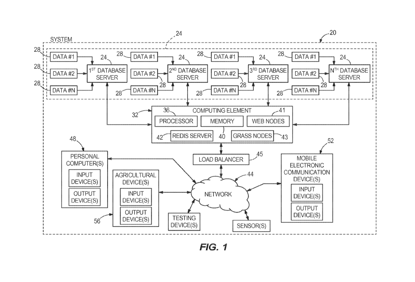
[00135] Fig. 1 is a block schematic diagram of one example of a system of the
present
disclosure, the system is configured to perform at least a portion of the
functionality and
methods of the present disclosure.
[00136] Fig. 2 is a block schematic diagram of another example of a system of
the present
disclosure, the system is configured to perform at least a portion of the
functionality and
methods of the present disclosure.
[00137] Fig. 3 is a front view of examples of devices that may be included in
one or more of
the systems, in this example the devices are a personal computer and a mobile
electronic
communication device.
[00138] Fig. 4 is one example of a visual format of data communicated by one
or more of the
systems, in this example the visual format is a map including a plurality of
zones color coded
based on soil characteristics.
[00139] Fig. 5 is one example of a visual format of data communicated by one
or more of the
systems, in this example the visual format is a map including a plurality of
zones color coded
based on seed characteristics.
[00140] Fig. 6 is one example of a visual format of data communicated by one
or more of the
systems, in this example the visual format is a chart and graphic illustrating
the impact of water
uptake, nutrient uptake and seed varieties on projected yields.
26
CA 02956205 2017-01-24
WO 2015/200489 PCT/US2015/037435
[00141] Fig. 7 is one example of a visual format of data communicated by one
or more of the
systems, in this example the visual format is a map including a plurality of
zones color coded
based on nitrogen characteristics.
[00142] Fig. 8 is an exemplary schematic illustration demonstrating that land
areas of interest
have varying slopes.
[00143] Fig. 9 is another exemplary illustration demonstrating that land areas
of interest have
varying slopes and associated properties in this example, the properties
determine whether the
land is shedding water or collecting water and rates at which the land is
doing so.
[00144] Fig. 10 is one example of a visual format of data communicated by one
or more of the
systems, in this example the visual format is a map including a plurality of
zones color coded
based on soil characteristics and contour lines for illustrating different
slopes.
[00145] Fig. 11 is one example of a visual format of data communicated by one
or more of the
systems, in this example the visual format is a map including a plurality of
zones color coded
based on soil characteristics and contour lines for illustrating different
slopes.
[00146] Fig. 12 is one example of a visual format of data communicated by one
or more of the
systems, in this example the visual format is a bar graph including a
plurality of bars of varying
heights for illustrating different slopes of a land area of interest.
[00147] Fig. 13 is one example of a visual format of data communicated by one
or more of the
systems, in this example the visual format is a map including contour lines
for illustrating
27
CA 02956205 2017-01-24
WO 2015/200489 PCT/US2015/037435
different slopes and a plurality of zones color coded based on water flow of
the land area of
interest.
[00148] Fig. 14 is one example of a visual format of data communicated by one
or more of the
systems, in this example the visual format includes a plurality of maps
illustrating weather data.
[00149] Fig. 15 is one example of a visual format of data communicated by one
or more of the
systems, in this example the visual format is an image of at least one
exemplary plant in a crop
planted on a land area of interest illustrating a growth state of the plant,
projected yield of the
crop, and a cross-sectional representation of an ear of corn at a particular
date.
[00150] Fig. 16 is one example of a visual format of data communicated by one
or more of the
systems, in this example the visual format is an image of at least one
exemplary plant in a crop
planted on a land area of interest illustrating a growth state of the plants,
projected yield of a
crop, and a cross-sectional representation of an ear of corn at a particular
date.
[00151] Fig. 17 is one example of a visual format of data communicated by one
or more of the
systems, in this example the visual format is a map including contour lines
for illustrating
different slopes and a plurality of zones color coded based on projected crop
yield of the land
area of interest.
[00152] Fig. 18 is one example of a visual format of data communicated by one
or more of the
systems, in this example the visual format is a bar graph for illustrating
percentage yield losses
as they relate to three agronomic factors, in this example the agronomic
factors are soil, seed
28
CA 02956205 2017-01-24
WO 2015/200489 PCT/US2015/037435
and weather and the agronomic factor that has a highest percentage yield loss
(weather in this
example) is a limiting factor.
[00153] Fig. 19 is one example of a visual format of data communicated by one
or more of the
systems, in this example the visual format is a bar graph for illustrating
percentage yield losses
as they relate to three agronomic factors, in this example the agronomic
factors are soil, seed
and weather and the agronomic factor that has a highest percentage yield loss
(seed in this
example) is a limiting factor.
[00154] Figs. 20-32 are multiple examples of visual formats of data
communicated by one or
more of the systems in the present disclosure.
[00155] Figs. 33A-33F are examples of visual formats of data communicate by
one or more of
the systems of the present disclosure, in this example the usual formats are a
chart.
[00156] Fig. 34 is one example of a visual format of data communicated by one
or more of the
systems of the present disclosure, in this example the visual format is a
chart illustrating one
example of end soil moisture ranges or categories.
[00157] Fig. 35 is one example of a visual format of data communicated by one
or more of the
systems of the present disclosure, in this example the visual format is a map
demonstrating
various end soil moistures across various zones, this exemplary map includes
one example of
color coded indicators for demonstrating end soil moistures in various zones.
29
CA 02956205 2017-01-24
WO 2015/200489 PCT/US2015/037435
[00158] Fig. 36 is one example of a visual format of data communicated by one
or more of the
systems of the present disclosure, in this example the visual format is a
chart illustrating another
example of a manner of determining end soil moisture.
DETAILED DESCRIPTION
[00159] The present disclosure provides systems, methods and apparatuses for
improving
agronomics in one or more land areas of interest, which may be comprised of
one or more fields
(or portions of a field) including one or more crops. The systems, methods and
apparatuses
receive and/or generate large quantities of data associated with agronomic
characteristics and/or
agronomic factors, analyze the data, characteristics and/or factors, and
provide agronomic
information to users based on the received and/or generated data,
characteristics and/or factors.
The agronomic information may be communicated to a device capable of
outputting the
agronomic information in any format (e.g., visual, audible, etc.) so the users
may take
appropriate action based on the agronomic information, or the agronomic
information may be
communicated directly to one or more agricultural device(s) where the
agricultural device(s)
may take appropriate action.
[00160] Many factors may impact and limit a crop's yield. The systems, methods
and
apparatuses of the present disclosure monitor, receive and/or generate
agronomic data
associated with the many factors that impact or limit a crop's yield and
optimize a crop's yield
based on the data. Agronomic data may be collected and/or generated in a
variety of manners
including, but not limited to, satellite, unmanned aerial vehicles, soil
samples from soil
CA 02956205 2017-01-24
WO 2015/200489 PCT/US2015/037435
sampling devices, cameras or other image capturing devices, ground sensors or
sensors located
anywhere or on anything relative to a crop or field, public weather data from
public databases,
seed characteristics, etc., and may be retrieved and/or generated by the
systems, methods and
apparatuses of the present disclosure. The systems, methods and apparatuses
process the
agronomic data to identify one or more limiting agronomic factors (i.e., the
agronomic factor(s)
preventing a crop from reaching a maximum yield). The systems, methods and
apparatuses of
the present disclosure are capable of receiving, collecting, retrieving,
determining, processing,
analyzing, etc., a wide variety of agronomic data, characteristics and/or
factors. Examples of
such data and factors include, but are not limited to: Growth cycle or growing
period; sunlight;
temperature; rooting; aeration; organic matter present in soil; water
quantity; nutrients (NPK);
water quality; salinity; sodicity; boron; chloride toxicities; pH;
micronutrients; other toxicities;
pests; diseases; weeds; flood; storm; wind; frost; seed variety
characteristics; soil slope; corn
moisture; weather patterns; economic characteristics, data or factors such as,
for example, seed
costs, cost per seed, input costs (e.g., nitrogen, irrigation, pesticides,
etc.), fuel costs, labor costs,
etc.; and other factors. Identifying the limiting agronomic factor for a
particular field and
accommodating or optimizing for the limiting factor may require multiple sets
of data including,
but not limited to: 1) Pre-planting information; 2) an accurate map of actual
plant progress; 3)
harvest information; and 4) post-harvest information. At least some of these
agronomic factors
will be described in more detail below to demonstrate exemplary principles of
the present
disclosure. Failure to address any particular agronomic factor with further
specificity is not
31
CA 02956205 2017-01-24
WO 2015/200489 PCT/US2015/037435
intended to be limiting upon the present disclosure in any manner. Rather, the
present
disclosure is intended to include all possible agronomic factors.
[00161] In one example, a growing cycle or growing period of a crop may be
considered a
period of time required for a crop to complete the states of a growth cycle. A
growth cycle may
include planting, establishment, growth, production of harvested part, and
harvesting. Some
crops are annual crops and complete their growth cycle once a year. In some
examples, crops
may be perennial crops and have growing cycles of more than one year. The
growing period for
annual crops may be a duration of the year when temperature, soil, water
supply and other
factors permit crop growth and development. The growing period is a major
determinant of
land suitability for crops and cultivars on a worldwide and continental scale.
Growth cycles and
growing periods differ around the World and are dependent upon the climates in
those portions
of the World.
[00162] Sunlight is another factor impacting growth of a crop. Sunlight may
have three
relevant aspects including, but not limited to: Day length; its influence on
photosynthesis and
dry matter accumulation in crops; and its effects on evapotranspiration.
Sunlight levels may also
be important in the drying and ripening of crops. The vegetative growth of
most plants increases
linearly with sunlight up to a limit beyond which no further increase occurs.
As plant
populations necessarily increase to keep up with increasing yield
expectations, sunlight may
become one of the most dominant growth-limiting factors. In one example, the
systems,
methods and apparatuses of the present disclosure may include one or more
sensors for
32
CA 02956205 2017-01-24
WO 2015/200489 PCT/US2015/037435
measuring sunlight and generating or creating data associated with the
measured sunlight for
further consideration by the systems, methods and apparatuses. In another
example, the
systems, methods and apparatuses may retrieve, collect or receive data
associated with sunlight
from a data source such as, for example, a database, containing sunlight data.
[00163] Temperature is another factor that impacts growth of a crop. Growth of
most crops
ceases below a critical low temperature and crops experience adverse effects
above very high
temperatures (usually above 86 - 95 degrees Fahrenheit). Between a minimum
temperature for
growth and an optimum temperature for photosynthesis, the rate of growth
increases more or
less linearly with temperature. The growth rate may then reach a plateau
within the optimum
temperature range before falling off at higher temperatures. Temperature also
interacts with
sunlight. Growth potential for crops may be achieved with both sunlight and
temperatures in
optimal ranges. In one example, the systems, methods and apparatuses of the
present disclosure
may include one or more thermometers for measuring temperature and generating
or creating
data associated with the measured sunlight for further consideration by the
systems, methods
and apparatuses. In another example, the systems, methods and apparatuses may
retrieve,
collect or receive data associated with temperature from a data source such
as, for example, a
database, containing temperature data.
[00164] Plants require water and nutrients, which are conveyed from the soil
to the productive
parts of the plants through roots. If root growth, or the development or
function of a root system
is impaired by adverse land characteristics (e.g., deficiencies or excessive
quantities of water,
33
CA 02956205 2017-01-24
WO 2015/200489 PCT/US2015/037435
nutrients, inputs, etc.), the growth and yield of the crop may likewise be
impaired. Root room is
a space for root development and may be limited in a variety of manners
including, but not
limited to: Effective soil depth; volume percent occupied (or not occupied) by
impediments;
impenetrable (or penetrable) soil volume; or other manners. Root-occupied soil
volume varies
with time in the case of annual crops developing root systems from seedling
establishment to
plant maturity and this process can be slowed by mechanical impedance.
Mechanical impedance
relates to soil strength and, in some examples, an amount of root penetration
force that roots
must exert or resistance they must overcome to penetrate the soil. Root room
and mechanical
impedance produce differences in water, nutrient, and other input uptake by
crops that affect
final yields, production or quality. In one example, the systems, methods and
apparatuses of the
present disclosure may include one or more sensors for measuring root growth,
root space, root
room and/or root penetration, and generating or creating data associated with
the measured root
characteristics for further consideration by the systems, methods and
apparatuses. In another
example, the systems, methods and apparatuses may retrieve, collect or receive
data associated
with root growth, root space, root room and/or root penetration from a data
source such as, for
example, a database, containing root growth, root space, root room and/or root
penetration data.
The systems, methods and apparatuses of the present disclosure may also
include one or more
devices for sampling root growth, root space, root room and/or root
penetration, and generating
or creating data associated with the measured root characteristics for further
consideration by
the systems, methods and apparatuses.
34
CA 02956205 2017-01-24
WO 2015/200489 PCT/US2015/037435
[00165] Respiring plant roots consume large quantities of oxygen and obtain
their oxygen
mainly through the soil. Thus, an adequate supply of oxygen through the soil
throughout the
growing season is a requirement for many crops. Poor aeration may lead to
inefficient use of
nitrogen applied in manures and fertilizers. Losses of nitrogen may occur from
denitrification
and leaching. Aeration may be addressed through permanent and/or temporary
field drains. In
one example, the systems, methods and apparatuses of the present disclosure
may include one
or more sensors for measuring oxygen content and/or oxygen consumption by
roots, and
generating or creating data associated with the measured oxygen content and/or
oxygen
consumption by the roots for further reconsideration by the systems, methods
and apparatuses.
In another example, the systems, methods and apparatuses may retrieve, collect
or receive data
associated with oxygen content and/or oxygen consumption by roots from a data
source such as,
for example, a database, containing oxygen content and/or oxygen consumption
by roots data.
The systems, methods and apparatuses of the present disclosure may also
include one or more
devices for sampling oxygen content and/or oxygen consumption by roots, and
generating or
creating data associated with the measured oxygen content and/or oxygen
consumption by the
roots for further reconsideration by the systems, methods and apparatuses.
[00166] Crop water requirement may be an amount of water necessary to meet
maximum
evapotranspiration rate of a crop when soil water is not limiting. In one
example,
evapotranspiration is a rate of water loss through transpiration from
vegetation, plus evaporation
from the soil surface or from standing water on the soil surface. When
irrigation is utilized, crop
CA 02956205 2017-01-24
WO 2015/200489 PCT/US2015/037435
water requirements are typically calculated by determining a net irrigation
water requirement
and then gross irrigation water requirements. In one example, net irrigation
water requirement
may be an amount of water required to meet the crop water requirement, minus
contributions in
the field by precipitation, run-on, groundwater and stored soil water, plus
field losses due to
run-off, seepage and percolation. In one example, gross irrigation water
requirement may be the
net irrigation water requirement, plus conveyance losses between a source of
water and a field,
plus any additional water for leaching over and above percolation. In one
example, the systems,
methods and apparatuses of the present disclosure may include one or more
sensors for
measuring crop water requirements and generating or creating data associated
with the
measured crop water requirement for further consideration by the systems,
methods and
apparatuses. In another example, the systems, methods and apparatuses may
retrieve, collect or
receive data associated with crop water requirements from a data source such
as, for example, a
database, containing crop water requirement data. The systems, methods and
apparatuses of the
present disclosure may also include one or more devices for sampling crop
water requirements
and generating or creating data associated with the sampled crop water
requirement for further
consideration by the systems, methods and apparatuses.
[00167] In some areas, crop water requirements may be partially provided by
rain falling
directly on land areas of interest (e.g., field(s)). In other areas, where
measurable rainfall is less
frequent and reliable, the crop water requirements may be provided by a
combination of rainfall
and/or irrigation through center pivot, drip tape or other irrigation methods.
With respect to
36
CA 02956205 2017-01-24
WO 2015/200489 PCT/US2015/037435
water requirements, not all the water received in a field is directly
effective. Part of the water
may be lost to run-off, deep percolation, or by evaporation of rain
intercepted by plant foliage.
Land characteristics such as slope, relief, infiltration rate, cracking,
permeability and soil
management may all influence crop water requirements.
[00168] Water quality becomes an issue when irrigation is utilized. In one
example, water
quality criteria may be generally interpreted in the context of, but not
limited to, salinity,
infiltration and toxicities and their effects on the soil. A salinity problem
can occur if a total
quantity of soluble salts accumulates in a crop root zone to an extent that
affects yields.
Excessive soluble salts in the root zone may be caused by irrigation water or
indigenous salt,
which may inhibit water uptake by plants. In such instances, the plants suffer
from salt-induced
drought. Infiltration problems occur when a rate of water infiltration into
and through the soil is
reduced (because of water quality) to such an extent that the crop is not
adequately supplied
with water, thereby resulting in reduced yield. Poor soil infiltration may
also add to cropping
difficulties through crusting of seed beds, waterlogging of surface soil and
accompanying
disease, salinity, weed, oxygen and nutritional problems. Toxicity issues
usually relate to higher
amounts of specific ions in the water, namely, boron, chloride and sodium. In
one example, the
systems, methods and apparatuses of the present disclosure may include one or
more sensors for
measuring water quality and generating or creating data associated with the
measured water
quality for further consideration by the systems, methods and apparatuses. In
another example,
the systems, methods and apparatuses may retrieve, collect or receive data
associated with water
37
CA 02956205 2017-01-24
WO 2015/200489 PCT/US2015/037435
quality from a data source such as, for example, a database, containing water
quality data. The
systems, methods and apparatuses of the present disclosure may also include
one or more
devices for sampling water quality and generating or creating data associated
with the measured
water quality for further consideration by the systems, methods and
apparatuses.
[00169] Nutrients are another factor that impact crop yield. In one example,
three major
nutrients are commonly applied as fertilizers to a crop. These nutrients
include: Nitrogen (N);
Phosphorous (P); and Potassium (K). In other examples, other nutrients may be
used as
fertilizer. The mineral composition of plant dry matter as a measure of crop
nutrient
requirements necessitates regular sampling during the life of the crop to
ensure accurate results.
However, crop nutrient uptake may be taken as the nutrient content of the
harvested crops,
which may provide a guide as to the nutrients required to maintain soil
fertility at about the
existing level. Supplies of plant nutrients to replace those removed at
harvest may come from,
for example: Soil mineralization (i.e. the transformation of soil minerals or
organic matter from
non-available into available nutrients); manures and fertilizers; or fixation
from the air. In one
example, the systems, methods and apparatuses of the present disclosure may
include one or
more sensors for measuring nutrient levels in the soil and generating or
creating data associated
with the measured nutrient levels for further consideration by the systems,
methods and
apparatuses. In another example, the systems, methods and apparatuses may
retrieve, collect or
receive data associated with nutrient levels from a data source such as, for
example, a database,
containing nutrient level data. The systems, methods and apparatuses of the
present disclosure
38
CA 02956205 2017-01-24
WO 2015/200489 PCT/US2015/037435
may also include one or more devices for sampling nutrient levels and
generating or creating
data associated with the measured nutrient levels for further consideration by
the systems,
methods and apparatuses.
[00170] Of these exemplary nutrients, the availability of nitrogen may be a
substantial factor
affecting yields. Nitrogen fertilizers give fairly predictable yields where
lack of nitrogen is a
principal limiting factor. Several considerations in determining a quantity of
nitrogen that
should be applied to obtain a given yield are, for example: Amounts of
nitrogen removed by the
crop; initial nitrogen content of the soil; contribution from nitrogen
fixation; and nitrogen losses
due to leaching, denitrification, etc. The cost of applying fertilizer
nitrogen may vary from land
unit to land unit. Soils requiring high nitrogen inputs may be initially low
in nitrogen, or may
utilize nitrogen applications inefficiently due to leaching or other losses.
In practice, however,
farmers often use the same amounts of fertilizer on a given land unit, and
yields from field to
field may vary on account of different efficiencies of utilization.
[00171] Insufficient regard for potential pest, disease and weed problems
commonly results in
poor crop performance. These problems can come in the form of, for example:
Wild animals;
arthropods including insects and mites; parasitic nematodes; fungal pathogens;
bacterial
pathogens; virus diseases; among others. In reconnaissance studies these
should be considered
in selecting alternative land areas. Climate plays a significant role in the
increased incidence of
many fungal and bacterial leaf diseases. For example, humid sites may be more
disease-prone
since the number of hours during which the leaf surface is wet often
encourages fungal and
39
CA 02956205 2017-01-24
WO 2015/200489 PCT/US2015/037435
bacterial pathogens, and reduces the effectiveness of control measures. The
impracticability of
weed control during periods of wet weather on heavy soils restricts the range
of crops that can
be grown and weeds that are not a problem early in the life of a project may
become so with
time or vice versa. Poorly drained soils predispose certain crops to root and
foot rots. Nematode
problems may be more severe on sandy soils than on clay soils. In one example,
the systems,
methods and apparatuses of the present disclosure may include one or more
sensors for
measuring infestation or other crop problems and generating or creating data
associated with the
measured infestation or other crop problems for further consideration by the
systems, methods
and apparatuses. In another example, the systems, methods and apparatuses may
retrieve,
collect or receive data associated with infestations or other crop problems
from a data source
such as, for example, a database, containing infestation data or other crop
problem data. The
systems, methods and apparatuses of the present disclosure may also include
one or more
devices for sampling infestation or other crop problems and generating or
creating data
associated with the measured infestation or other crop problems for further
consideration by the
systems, methods and apparatuses.
[00172] As one can see a variety of factors may impact crop yield. It is
important for the
systems, methods and apparatuses of the present disclosure to consider as much
data or as many
agronomic characteristics and/or factors as possible in order to provide as
accurate an
assessment of the scenario in the land area of interest as possible, which may
result in
optimizing crop yield, reducing the cost associated with growing a crop, and
reducing
CA 02956205 2017-01-24
WO 2015/200489 PCT/US2015/037435
environmental impacts when growing crops. The following examples of systems,
methods and
apparatuses are provided to demonstrate principles of the present disclosure
and are not
intended to limit the present disclosure in any manner. Other examples and
alternative systems,
methods and apparatuses are possible and are intended to be within the spirit
and scope of the
present disclosure.
[00173] With reference to Fig. 1, one example of a system 20 of the present
disclosure is
illustrated. The system 20 is one example of many systems of the present
disclosure and is not
intended to limit the present disclosure in any manner. The exemplary system
20 is provided to
demonstrate at least some of the principles of the disclosure. The system 20
is capable of
performing all the functionalities, operations and methods of the present
disclosure and includes
all the necessary hardware and software to achieve the functionalities,
operations and methods
of the present disclosure. While the present disclosure may describe in detail
at least a portion
of the hardware and software required to achieve the functionalities,
operations and methods of
the present disclosure, the present disclosure is not intended to be limited
to only the hardware
and software described and illustrated, but rather is intended to include any
hardware and
software required. If any such hardware and software may be omitted from the
description
and/or drawings, such hardware and/or software may be conventional items known
to those
skilled in the art and the omission of such items may be a result of their
conventionality.
[00174] With continued reference to Fig. 1, the exemplary system 20 includes a
plurality of
databases or database servers 24. In one example, the databases or database
servers 24 may be
41
CA 02956205 2017-01-24
WO 2015/200489 PCT/US2015/037435
only databases and in other examples the databases or database servers 24 may
be database
servers. For the sake of simplicity, elements 24 will be referred to
hereinafter as databases,
however, it should be understood that elements 24 may be either or both
databases and database
servers. In one example, the databases 24 store a variety of types of data or
information. In
other examples, the databases 24 store data as suggested above and
additionally perform
calculations and/or other functionality associated with the system and methods
of the present
disclosure. The system 20 may include any number of databases 24 as
represented by the three
databases and an Nth Database. The databases 24 may relate to any aspect of
agronomics.
Each database 24 may pertain to a different characteristic of agronomics, each
database 24 may
pertain to multiple characteristics of agronomics, or multiple databases 24
may pertain to
similar agronomic characteristics. In the illustrated example, each of the
databases 24 is
configured to receive and/or store any quantity of data 28 as represented by
Data #1, Data #2
and Data Nth. The databases 24 may receive and/or store as few as one data
input 28 or may
receive and/or store any number of data inputs 28. Moreover, the data 28
received and/or stored
by the databases 24 may pertain to any agronomic characteristics, factor or
data. In one
example, the data 28 received and/or stored by each database 24 will relate to
the agronomic
characteristic associated with the database 24. For example, if the database
24 is a weather
database, the data 28 received and/or stored by the database 24 will pertain
to weather. Also,
for example, if the database 24 is a soil database, the data 28 received
and/or stored by the
database 24 will pertain to soil. In one example, the system 20 may include
only a single
42
CA 02956205 2017-01-24
WO 2015/200489 PCT/US2015/037435
database 24 (see dashed box 24 in Fig. 1), which includes all the features,
characteristics and
functionality associated with the multiple databases illustrated in Fig. 1.
[00175] In one example, the databases 24 are configured to store the received
data 28 therein
for use by a computing element 32. The computing element 32 communicates with
the
databases 24 to retrieve and send information or data as necessary. The
computing element 32
may include any necessary hardware, software or any combination thereof to
achieve the
processes, methods, functionalities, operations, etc., of the present
disclosure. In one example,
the computing element 32 is a web server and includes all the conventional
hardware and
software associated with a web server.
[00176] In one example, the computing element 32 may be comprised of one or
more of
software and/or hardware in any proportion. In such an example, the computing
element 32
may reside on a computer-based platform such as, for example, a server or set
of servers. Any
such server or servers may be a physical server(s) or a virtual machine(s)
executing on another
hardware platform or platforms. The nature of the configuration of such server
or servers is not
critical to the present disclosure. Any server, or for that matter any
computer-based system,
systems or elements described herein, will be generally characterized by one
or more processors
and associated processing elements and storage devices communicatively
interconnected to one
another by one or more busses or other communication mechanism for
communicating
information or data. In one example, storage within such devices may include a
main memory
such as, for example, a random access memory (RAM) or other dynamic storage
devices, for
43
CA 02956205 2017-01-24
WO 2015/200489 PCT/US2015/037435
storing information and instructions to be executed by the processor(s) and
for storing
temporary variables or other intermediate information during the use of the
system and
computing element described herein. In one example, the system 20 and/or the
computing
element 32 may also include a static storage device such as, for example, read
only memory
(ROM), for storing static information and instructions for the processor(s).
In one example, the
system 20 and/or the computing element 32 may include a storage device such
as, for example,
a hard disk or solid state memory, for storing information and instructions.
Such storing
information and instructions may include, but not be limited to, instructions
to compute, which
may include, but not be limited to processing and analyzing agronomic data or
information of
all types. Such agronomic data or information may pertain to, but not be
limited to, weather,
soil, water, crop growth stage, infestation data, historical data, future
forecast data, economic
data associated with agronomics or any other type of agronomic data or
information. In one
example, the system's and/or computing element's processing and analyzing of
agronomic data
may pertain to processing and analyzing limiting agronomic factors obtained
from externally
gathered image data, and issue alerts if so required based on pre-defined
acceptability
parameters. RAMs, ROMs, hard disks, solid state memories, and the like, are
all examples of
tangible computer readable media, which may be used to store instructions
which comprise
processes, methods and functionalities of the present disclosure. Exemplary
processes, methods
and functionalities of the system 20 and/or computing element 32 may include
determining a
necessity for generating and presenting alerts in accordance with examples of
the present
44
CA 02956205 2017-01-24
WO 2015/200489 PCT/US2015/037435
disclosure. Execution of such instructions by the system 20 and/or the
computing element 32
causes the various computer-based elements of the system 20 and the computing
element 32 to
perform the processes, methods, functionalities, operations, etc., described
herein. In some
examples, the systems 20 and the computing elements 32 of the present
disclosure may include
hard-wired circuitry to be used in place of or in combination with, in any
proportion, such
computer-readable instructions to implement the disclosure.
[00177] In one example, such as the example illustrated in Fig. 1, the
computing element 32
may include a processor 36, memory 40, one or more web nodes 41, a REDIS
server 42 and one
or more GRASS nodes 43. In one example, the web nodes 41 may be servers or
other elements
comprised of one or both of hardware and/or software to handle requests from a
load balancer
45. In one example, the load balancer may be a server or other element
comprised of one or
both of hardware and/or software that passes off or allocates requests from a
network 44 (e.g.,
from a web browser) to the computing element 32. In one example, the one or
more web nodes
may be one or more servers that handle requests from the load balancer,
retrieve data from
database or memory, perform calculations, and send data and user interface(s)
back to the
network 44 (e.g., back to the web browser). The system 20 and/or the computing
element 32
are capable of including any number of web nodes. In one example, the system
20 and/or
computing element 32 include six web nodes. In one example, the REDIS server
may be a
temporary and fast data storage element for behind the scenes capabilities
that may control a
data cache. In one example, the REDIS server may hold short term data that may
not be
CA 02956205 2017-01-24
WO 2015/200489 PCT/US2015/037435
required for storing long term in another database or may hold data that are
frequently accessed
to allow quicker performance than if the data was stored in a long term
database. In one
example, the one or more GRASS nodes may be one or more servers that may run a
GIS
program. The one or more GRASS nodes may accept shape files from a web node
and process
the shape files into land areas of interest with slope. The GRASS nodes may
return a file or
data to a web node where the file or data is stored in one or more databases
24 for use by the
system 20. The system 20 and/or computing element 32 may include any number of
GRASS
nodes. In one example, the system 20 and/or computing element 32 include four
GRASS
nodes.
[00178] In one example, to facilitate user interaction, collection of
information, and provision
of results, the systems 20 of the present disclosure may include one or more
output devices such
as, for example, a display device, though such a display may not be included
with a server,
which may communicate results to a client/manager station (via an associated
user/client/manager interface) rather than presenting the same locally.
User/client/manager
stations may also include one or more input devices such as, for example,
keyboards, touch
screens, and/or mice (or similar input devices) for communicating information
and command
selections to the local station(s) and/or server(s). Additionally, the system
20 may output,
communicate or transmit data over one or more networks to external or
independent devices
such as, for example, mobile electronic communication devices, agricultural
devices, etc.
46
CA 02956205 2017-01-24
WO 2015/200489 PCT/US2015/037435
[00179] In one example, the computing element 32 may include at least one
conventional
processor 36 and at least one conventional type memory 40. The memory 40
stores necessary
data therein that may be retrieved by the processor 36 in order for the
computing element 32 to
perform the operations, functionalities, methods, etc., of the present
disclosure. The processor
36 may also store data as necessary in the memory 40 for later use.
Functionalities, operations,
methods, etc., of the computing element 32 and the system 20 will be described
in greater detail
below.
[00180] With continued reference to Fig. 1, the computing element 32 is
configured to
communicate over one or more networks 44. In the illustrated example, only one
network 44 is
illustrated; however, the computing element 32 is capable of communicating
over multiple
networks 44. In examples where the computing element 32 may communicate over
multiple
networks 44, the computing element 32 may communicate over the networks 44
contemporaneously or independently (e.g., one at a time). The computing
element 32
selectively communicates over a desired network 44 when communicating
independently. The
network 44 may be a wide variety of types of networks and the present
disclosure contemplates
using any type of network. For example, the network 44 may be one of an
Internet, an intranet,
a cellular network, a local area network (LAN), a wide area network (WAN), a
cable network,
or any other type of network that is capable of transmitting information, such
as digital data, and
the like. In examples where the system 20 includes multiple networks 44, the
multiple networks
47
CA 02956205 2017-01-24
WO 2015/200489 PCT/US2015/037435
44 may be similar types of networks or the networks 44 may be different types
of networks.
For example, the system 20 may communicate over a cellular network and over
the Internet.
[00181] The computing element 32 is configured to communicate data to a wide
variety of
devices over one or more networks 44 and any such devices are intended to be
within the spirit
and scope of the present disclosure. In the illustrated example, the computing
element 32 is
configured to communicate over one or more networks 44 with personal computers
48, mobile
electronic communication devices 52, and/or agricultural devices 56. The
mobile electronic
communication devices 52 may be a wide variety of devices including, but not
limited to, a
personal desktop assistant (PDA), a portable computer, a mobile telephone, a
smartphone, a
netbook, a mobile vehicular computer, a tablet computer, or any other type of
mobile electronic
communication device. Examples of personal computers 48 and mobile
electronic
communication devices 52 are illustrated in Fig. 3. The agricultural devices
56 may be a wide
variety of agricultural devices including, but not limited to, tractors,
planters, harvesters,
sprayers, any input application device, irrigation devices, soil sampling
devices, agronomic
sensors, agronomic devices for sampling agronomic characteristics, etc. The
computing
element 32 is also configured to communicate over one or more networks 44 with
a single
device at a time or multiple devices contemporaneously or intermittently. For
example, the
computing element 32 may communicate with a user's smartphone over a cellular
network.
Also, for example, the computing element 32 may communicate with a tractor
over a cellular
network. Further, for example, the computing element 32 may communicate with a
user's
48
CA 02956205 2017-01-24
WO 2015/200489 PCT/US2015/037435
personal computer over the Internet and communicate with the user's smartphone
over a cellular
network.
[00182] The system 20 and computing element 32 are capable of performing a
wide variety of
functionalities or operations that improve agronomic conditions. For example,
the computing
element 32 receives one or more types of data from one or more databases 24,
analyzes the one
or more types of data and communicates data to one or more devices 48, 52, 56
over one or
more networks 44 pertaining to the analyzed agronomic data. The data
communicated to the
one or more devices will assist with improving the agronomic conditions of a
particular land
area of interest that includes one or more fields (or portion of a field) and
one or more crops. In
one example, the communicated data may be viewed by a user, farmer, crop
consultant,
agronomist, etc. (collectively referred to hereafter as "user") or a device
such as a mobile
electronic communication device, personal computer, or display on an
agricultural device, and
the user may take action in accordance with the communicated data. In one
example, the
communicated data is communicated to one or more agricultural devices 56 and
the one or more
agricultural devices 56 may operate or be operated by a user in accordance
with the
communicated data. In one example, communicated data may be communicated to a
device 48,
52 where a user may view the data in a visual format (see Fig. 3) and also be
communicated to
one or more agricultural devices 56. In this example, the user may take action
based on the
communicated data and the one or more agricultural devices 56 may operate in
accordance with
the communicated data.
49
CA 02956205 2017-01-24
WO 2015/200489 PCT/US2015/037435
[00183] Referring now to Fig. 2, another example of a system 20 of the present
disclosure is
illustrated. The system 20 illustrated in Fig. 2 is one example of many
possible systems of the
present disclosure and is not intended to limit the present disclosure in any
manner. Rather, the
exemplary system 20 is provided to demonstrate principles of the disclosure.
The system 20 is
capable of performing all the functionalities, operations, methods, etc., of
the present disclosure
and includes all the necessary hardware and software to achieve the
functionalities, operations,
methods, etc., of the present disclosure. While the present disclosure may
describe in detail at
least a portion of the hardware and software required to achieve the
functionalities, operations,
methods, etc., of the present disclosure, the present disclosure is not
intended to be limited to
only the hardware and software described and illustrated, but rather is
intended to include any
hardware and software required. If any such hardware and software may be
omitted from the
description and/or drawings, such hardware and/or software may be conventional
items known
to those skilled in the art and the omission of such items may be a result of
their
conventionality.
[00184] With continued reference to Fig. 2, the exemplary system 20 includes
three databases
or database servers 24A, 24B, 24C for storing a variety of types of data or
information.
Reference is made to the description above pertaining to Fig. 1 with respect
to databases and
database servers and all of such description above applies to the system 20
illustrated in Fig. 2
and described herein. The three databases include a soil database 24A, a seed
database 24B and
a weather database 24C. Each database 24A, 24B, 24C is configured to receive
and store data
CA 02956205 2017-01-24
WO 2015/200489 PCT/US2015/037435
28 associated with the agronomic characteristic of the database 24A, 24B, 24C
(e.g., soil, seed
and weather, respectively). In this example, the soil database 24A may collect
or receive GPS
soil test data, LiDar data, SSURGO data, crowd source calibrated soils data,
and data from
social media (e.g., FACEBOOK, TWITTER, INSTAGRAM, etc.). In one example,
through
the use of social media, peer users may compare soil, seed and weather
information with others,
including those other users who have land areas in relative proximity and
therefore may be
subject to similar soil, seed and weather conditions. In some examples,
databases 24A, 24B,
24C may be supplemented with information provided by a social media. In this
example, the
system 20 is configured to allow one or more users to communicate information
between one
another that may be relevant to soil, seed and weather status, status updates
of current crops for
peer farmers, or prescriptions and strategies of peer farmers. On some
occasions, the system 20
may receive data via a social network from other users and store said data in
an appropriate
database(s). In one example, pest problems on a nearby field operated by
another farmer may be
relevant to the user's fields; e.g., rootworm or aphids on a nearby field with
a crop similar to a
user's fields.
[00185] The seed database 24B may collect or receive and store replicated plot
data and user
knowledge data. The weather database 24C may collect or receive and store
national weather
service data, other weather service data (e.g., The Weather Channel data,
Weather Underground
data, etc.), and user knowledge data. The soil database 24A, seed database 24B
and weather
database 24C store this data 28 for retrieval by the computing element 32.
51
CA 02956205 2017-01-24
WO 2015/200489 PCT/US2015/037435
[00186] In one example, the system 20 illustrated in Fig. 2 may include only a
single database
24 (see dashed box 24 in Fig. 2), which includes all the features,
characteristics and
functionality associated with the multiple databases illustrated in Fig. 2.
[00187] It should be understood that the data 28 described and illustrated in
the context of this
example are presented for exemplary purposes to demonstrate at least some of
the principles of
the present disclosure and are not intended to limit the present disclosure in
any manner. Rather,
any type of data associated with soil, seed and weather may be received and
stored in the
respective databases and all of such possibilities are intended to be within
the spirit and scope of
the present disclosure.
[00188] The databases 24A, 24B, 24C are configured to store the received data
28 therein for
use by the computing element 32. The computing element 32 communicates with
the databases
24A, 24B, 24C to retrieve and send data as necessary. The computing element 32
may include
any necessary hardware, software and any combination thereof to achieve the
functionalities,
operations, methods, etc., of the present disclosure. In one example, the
computing element 32
is a web server and may include all the conventional hardware and software
associated with a
web server. In one example, the computing element 32 may include at least one
conventional
processor 36 and at least one conventional type of memory 40. The memory 40
stores
necessary data therein that may be retrieved by the processor 36 in order for
the computing
element 32 to achieve the functionalities, operations, methods, etc., of the
present disclosure.
The processor 36 may also store data as necessary in the memory 40 for later
use. The
52
CA 02956205 2017-01-24
WO 2015/200489 PCT/US2015/037435
computing element associated with Fig. 2 is capable of being similar to the
computing element
associated with Fig. 1. Thus, the description above associated with the
computing element of
Fig. 1 may apply to the computing element associated with Fig. 2.
[00189] In one example, the system 20 illustrated in Fig. 2 is capable of
including a load
balancer 45 similar to the load balancer illustrated in Fig. 1 and described
above. Thus, the
description above associated with the load balancer of Fig. 1 may apply to the
load balancer
associated with Fig. 2.
[00190] With continued reference to Fig. 2, the computing element 32 is
configured to
communicate over one or more networks 44. In the illustrated example, only one
network 44 is
illustrated; however, the computing element 32 is capable of communicating
over multiple
networks 44. In examples where the computing element 32 may communicate over
multiple
networks 44, the computing element 32 may communicate over the networks 44
contemporaneously or independently (e.g., one at a time). The computing
element 32
selectively communicates over a desired network 44 when communicating
independently. The
network 44 may be a wide variety of types of networks and the present
disclosure contemplates
using any type of network. For example, the network 44 may be one of an
Internet, an intranet,
a cellular network, a local area network (LAN), a wide area network (WAN), a
cable network,
or any other type of network that is capable of transmitting information, such
as digital data, and
the like. In examples where the system 20 includes multiple networks 44, the
multiple networks
53
CA 02956205 2017-01-24
WO 2015/200489 PCT/US2015/037435
44 may be similar types of networks or the networks 44 may be different types
of networks.
For example, the system 20 may communicate over a cellular network and over
the Internet.
[00191] The computing element 32 is configured to communicate data to a wide
variety of
devices over one or more networks 44 and any such devices are intended to be
within the spirit
and scope of the present disclosure. In the illustrated example, the computing
element 32 is
configured to communicate over one or more networks 44 with personal computers
48, mobile
electronic communication devices 52, and agricultural devices 56. Examples of
personal
computers 48 and mobile electronic devices 52 are illustrated in Fig. 3.
Reference is made to
the description presented above in connection with Fig. 1 pertaining to the
devices with which
the computing element 32 is configured to communicate, and all of such
possibilities also apply
to the devices associated with the system 20 illustrated and described in
connection with Fig. 2.
[00192] The system 20 and computing element 32 are capable of performing a
wide variety of
functionalities, operations, methods, etc., that improve agronomic conditions.
For example, the
computing element 32 receives, retrieves or collects one or more types of data
from one or more
databases 24A, 24B, 24C, analyzes the one or more types of data and
communicates data to one
or more devices 48, 52, 56 over one or more networks 44 pertaining to the
analyzed agronomic
data. The data communicated to the one or more devices 48, 52, 56 will assist
with improving
the agronomic conditions of a particular land area of interest that includes
one or more fields (or
a portion of a field) and one or more crops. In one example, the communicated
data may be
viewed by a user on one or more devices 48, 52, 56 and the user may take
action in accordance
54
CA 02956205 2017-01-24
WO 2015/200489 PCT/US2015/037435
with the communicated data or a user may operate one or more agricultural
devices in
accordance with the communicated data. In one example, the communicated data
is
communicated to one or more agricultural devices 56 and the one or more
agricultural devices
56 may operate in accordance with the communicated data. In one example,
communicated
data may be communicated to a device 48, 52 where a user may view the data in
a visual format
(see, e.g., Fig. 3) and also be communicated to one or more agricultural
devices 56. In this
example, the user may take action based on the communicated data and the one
or more
agricultural devices 56 may operate in accordance with the communicated data.
[00193] More specifically, for example, the computing element 32 may receive,
retrieve or
collect data from the soil database 24A, analyze the data 28 relating to soil
and communicate
data to one or more devices 48, 52, 56 over one or more networks 44 pertaining
to the analyzed
soil data 28. The soil data communicated to the one or more devices 48, 52, 56
may assist with
improving agronomic conditions of a land area of interest, field or crop as
they relate to soil.
Also, for example, the computing element 32 may receive data from the seed
database 24B,
analyze the data 28 relating to seed and communicate data to one or more
devices 48, 52, 56
over one or more networks 44 pertaining to the analyzed seed data 28. The seed
data
communicated to the one or more devices 48, 52, 56 may assist with improving
agronomic
conditions of a particular land area of interest, field or crop as they relate
to seed. Further, for
example, the computing element 32 may receive, retrieve or collect data from
the weather
database 24C, analyze the data 28 relating to weather and communicate data to
one or more
CA 02956205 2017-01-24
WO 2015/200489 PCT/US2015/037435
devices 48, 52, 56 over one or more networks 44 pertaining to the analyzed
weather data 28.
The weather data communicated to the one or more devices 48, 52, 56 may assist
with
improving agronomic conditions of a particular land area of interest, field or
crop as they relate
to weather. The computing element 32 may retrieve, receive or collect only one
of soil, seed or
weather data 28 at a time and analyze only the one retrieved data 28, or the
computing element
32 may retrieve, receive or collect any number and combination of soil, seed
and weather data
28. In examples where only one type of data is retrieved and analyzed, only
that single criteria
is contemplated to improve the agronomic conditions of a particular land area
of interest, field
and/or crop. In examples where more than one type of data is retrieved and
analyzed, the
multiple data may be contemplated in unison and their combined effect on
agronomic
conditions of a particular land area of interest, field and/or crop may be
considered to improve
the agronomic conditions.
[00194] In one example, the communicated soil, seed and/or weather data 28 may
be viewed
by a user on one or more devices 48, 52, 56 and the user may take action in
accordance with the
communicated soil, seed and/or weather data 28. In one example, the
communicated soil, seed
and/or weather data 28 is communicated to one or more agricultural devices 56
and the one or
more agricultural devices 56 may operate in accordance with the communicated
soil, seed
and/or weather data 28 or the user may operate the agricultural device 56 in
accordance with the
communicated soil, seed and/or weather data 28. In one example, communicated
soil, seed
and/or weather data 28 may be communicated to a device 48, 52 where a user may
view the
56
CA 02956205 2017-01-24
WO 2015/200489 PCT/US2015/037435
soil, seed and/or weather data 28 and also be communicated to one or more
agricultural devices
56. In this example, both the user may take action based on the communicated
soil, seed and/or
weather data 28 and the one or more agricultural devices 56 may operate in
accordance with the
communicated soil, seed and/or weather data 28.
[00195] The system 20 and computing element 32 may be utilized in a variety of
manners. In
one example, the system 20 and computing element 32 may be used to perform pre-
season crop
planning. In another example, the system 20 and computing element 32 may be
used to perform
in-season monitoring and adjustment. The system 20 and computing element 32
may analyze
and output or communicate data in a similar manner in both pre-season and in-
season examples,
but a difference between pre-season and in-season examples may occur depending
on how the
communicated data is utilized. For example, in pre-season crop planning, a
user may input or
retrieve various combinations of data for the computing element 32 to analyze
and the outputted
or communicated data may simply be viewed by the user and/or stored for later
viewing or use,
without actually taking action on a crop or with an agricultural device. For
in-season scenarios,
for example, actual data occurring in real-time may be input into or retrieved
by the computing
element 32, the computing element 32 analyzes the data, outputs data to be
viewed by a user,
and the user may take action based on the outputted data or the outputted data
may be
communicated to an agricultural device to control operation of the
agricultural device.
[00196] The data communicated to the user by the computing element 32 may have
several
benefits and assist the user in many ways whether the computing element 32 is
used for pre-
57
CA 02956205 2017-01-24
WO 2015/200489 PCT/US2015/037435
season crop planning or in-season adjustment. For example, the computing
element 32 may
analyze seed types or varieties to determine appropriateness of the user
specified/selected seed
type or variety, determine the most appropriate planting date, determine the
most appropriate
seed rate (e.g., how many seeds to plant per acre), determine the most
appropriate amounts of
inputs to apply to a crop, determine which inputs to apply to a crop,
determine most appropriate
time to harvest the crop, improve crop yields by performing the preceding
aspects, improve the
efficiency of the planting process and reduce a user's cost by performing the
preceding aspects,
decreasing the impact on the environment from the planting process by
performing the
preceding aspects, among others.
[00197] In one example of pre-season and/or in-season crop planning, with
reference to Figs.
20-32, the system 20 and the computing element 32 may analyze a large quantity
or all possible
iterations of pre-season crop planning data to solve for ideal pre-season crop
planning data, e.g.,
the highest possible crop yield, highest possible crop yield with lowest plant
population, or
many others. In another example, the system 20 and computing element 32 do not
analyze all
of the possible iterations but select random combinations of pre-season crop
planning data,
establish upper and lower limits for yield loss, and continue iterating until
the dataset has been
narrowed down to only a handful of combinations showing the highest possible
crop yield at the
lowest possible plant population.
[00198] With particular reference to Figs. 20-24, one example of a visual
format provided by
the system 20 is provided as it relates to a limiting factor. This visual
format may be displayed
58
CA 02956205 2017-01-24
WO 2015/200489 PCT/US2015/037435
on a display of any electronic device of the system 20 and capable of being
viewed by a user.
This example is not intended to be limiting. Rather, this example is provided
to demonstrate
some of the principles of the present disclosure. With reference to Fig. 20, a
plurality of land
areas of interest, zones or fields are represented in the various rows. For
all of these land areas
of interest, nitrogen is identified by the computing element 32 as the
limiting factor (see fourth
column with the header "Limiting Factor"). This represents to a user that the
land areas of
interest illustrated in Fig. 20 have a shortage of nitrogen. Depending on
whether the user is
using the system for pre-season planning analysis or in season analysis, a
user may either
actually go to the land area of interest and apply more nitrogen to the land
area of interest (for in
season scenarios) and input the amount of nitrogen added into the system 20 or
the user may
merely adjust the amount of nitrogen using an input device on the electronic
device (for pre-
season planning analysis). Either way, Fig. 21 accounts for the increase in
nitrogen to the land
areas of interest, thereby resulting in a larger crop yield for most of the
land areas of interest
(see third column from left). Since nitrogen has been added, nitrogen is no
longer the limiting
factor. Instead, Fig. 21 now shows seed as the limiting factor for some of the
land areas of
interest (see fourth column). Figs. 22-24 show additional visual formats of
this example when
considering different values of agricultural characteristics and/or performing
different activities.
[00199] With reference to Figs. 25 and 26, the system 20 is configured to
allow introduction of
an irrigation system into the system associated with a land area of interest.
A land area of
interest may not initially have an irrigation system when considered by the
system 20.
59
CA 02956205 2017-01-24
WO 2015/200489 PCT/US2015/037435
Subsequently an irrigation system may be added and it is important for the
impact of irrigating
on the land area of interest to be considered. With reference to Fig. 25, the
system 20 displays
one example of a visual format on a display of an electronic device for
viewing by the user.
The visual format includes an icon selectable by a user to add an irrigation
system to the land
area of interest. A user selects the icon and the visual format illustrated in
Fig. 26 is displayed
on a display of an electronic device for viewing by a user. The visual format
illustrated in Fig.
26 includes several sections where information pertaining to the irrigation
system may be
inputted. The user may input the appropriate information with an input device
associated with
the electronic device. With reference to Figs. 27 and 28, various visual
formats displayable by
the system 20 are illustrated and account for water now that irrigation was
added in connection
with Figs. 25 and 26. Figs. 29-32 illustrate various visual formats displayed
by the system 20
on displays of an electronic device. The visual formats illustrate an
irrigation system overlaid on
land areas of interest.
[00200] In one example of in-season adjustments, the system 20 and the
computing element 32
may analyze a large quantity of or all possible iterations of agronomic
factors to solve for the
limiting agronomic factor. In another example, the system 20 and computing
element 32 do not
analyze all of the possible iterations but select random combinations of
agronomic factors,
establish upper and lower limits for yield loss, and continue iterating until
the dataset has been
narrowed down to only a handful of combinations from which the user can
identify the limiting
agronomic factor.
CA 02956205 2017-01-24
WO 2015/200489 PCT/US2015/037435
[00201] As indicated above, the system 20 and computing element 32 of the
present disclosure
have a variety of features, functionalities, operations, methods, etc. The
following features,
functionalities operations, methods, etc., are not intended to be limiting
upon the present
disclosure, but rather are provided as examples to demonstrate principles of
the present
disclosure. Other features, functionalities, operations, methods, etc., may be
possible and are
intended to be within the spirit and scope of the present disclosure.
[00202] In one example, a system 20 provides the ability for a user to upload
data or
information pertaining to a land area of interest. This land area of interest
may be a single field,
a portion of a field, a plurality of fields, or other land area of interest.
For purposes of this
description and for simplifying the description, the word land or phrase land
area of interest will
be referred to herein and can account for any size of land and any number of
fields, including
one field or a portion of a field.
[00203] In one example, to begin use of the system 20, data associated with
the land area of
interest must be introduced, uploaded or communicated into the system 20. The
land data may
be uploaded into the system 20 in a variety of manners. In one example, the
user may input
(via, e.g., a keyboard, mouse, touch screen, storage medium such as, for
example, memory
stick, or any other type of input device) data associated with the land such
as, for example, a
name of the farmer/grower, name of the farm, name of the land or field, etc.
Then the user may
select a land area of interest (e.g., a common land unit) from a farm service
agency (FSA)
including field maps with the system 20. If the land area of interest includes
more than one
61
CA 02956205 2017-01-24
WO 2015/200489 PCT/US2015/037435
field, the user may select multiple land areas of interest from the FSA and
such land areas of
interest may be grouped together and associated with the data input by the
user.
[00204] With reference to Fig. 4, one example of a land area of interest 60 is
illustrated. In this
example, the land area of interest 60 includes a plurality of zones 64. The
different shading in
the zones 64 may represent different characteristics between zones 64. The
different
characteristics may be a wide variety of characteristics and all of such
possibilities are intended
to be within the spirit and scope of the present disclosure. For example, the
different
characteristics may relate to, but are not limited to, differences in soil
characteristics, plant
population, etc. Such soil differences may pertain to, but are not limited to,
quantity of organic
matter present in soil, pH, phosphorous content, nitrogen content, potassium
content, cation
exchange capacity, slope, etc.
[00205] In another example, the land data may be uploaded into the system 20
in one or more
bulk files such as, for example, one or more binary spatial coverage files.
Such a bulk file
includes all the necessary information associated with the land area of
interest 60. In this
example, the land data is exported to a binary spatial coverage file. Such
exported information
may include, but is not limited to, soil type layer or customized management
zone with
MUSYM (map unit symbol) attribute. Once such data is uploaded to the system
20,
Geographic Information Systems (GIS) software may name each file within the
bulk file by
field name. GIS software may obtain desired land data and may include all the
necessary land
data for the land area of interest. When the land data is uploaded in bulk,
the system 20 uses
62
CA 02956205 2017-01-24
WO 2015/200489 PCT/US2015/037435
the file name to assign the field name by default. Names may be subsequently
edited. If too
many files are uploaded, the unwanted files may be subsequently deleted. The
system 20
provides the ability to export all files, upload all files, then provides a
preview where a user may
select and delete unwanted files. Once the land files are uploaded, the system
20 links standard
practices and weather forecasts, and determines land, field and/or zone
centroids for
establishing virtual rain gauges with the uploaded land files.
[00206] Field centroids are determined, in one example, by geographic
midpoint. In one
example, the system 20 may calculate the geographic midpoint by finding a
center of gravity for
the land area of interest. The system 20 may convert the latitude and
longitude for each land
area of interest into Cartesian (x,y,z) coordinates. The system 20 may
multiply the x, y, and z
coordinates by a weighting factor and add them together. A line can be drawn
from a center of
the earth out to this new x, y, z coordinate, and the point where the line
intersects the surface of
the earth is the geographic midpoint. The system 20 converts this surface
point into latitude and
longitude for the midpoint. This is one example of the system 20 determining
the centroid of a
land area of interest. The system 20 may determine the field centroid in a
variety of other
manners including, but not limited to, triangle centroids, plumb line method,
integral formula,
balancing method, finite set of points, geometric decomposition, bounded
regions, L-shaped,
polygon, cone, pyramid, or other manners. The system 20 determining the field
centroid allows
a user to upload large quantities of files associated with a large number of
fields or land area(s)
63
CA 02956205 2017-01-24
WO 2015/200489 PCT/US2015/037435
of interest and identifying each of the fields or land area(s) of interest
using the associated
centroid(s) without the use of a land/field identifier (typically a 12 digit
field code).
[00207] In one example, the system 20 is configured to determine if duplicate
files having the
same, substantially the same or overlapping zone or land area boundaries. In
such an example,
files may be associated with one another based on their boundary and
duplicates may be
determined based on the boundaries. In this example, the system 20 may
display, output or
otherwise prompt a user with information identifying the potentially
duplicative files. The user
may then make a selection via an input device whether the files are
duplicative. If the user
indicates that the files are duplicative, the system 20 may delete one of the
duplicative files. In
one example, each land area or zone file and its associated boundary may be
associated with a
centroid. Then, the system 20 may measure or determine distances between the
centroids of the
land area or zone files. In some examples, distances between the centroids may
be used to
identify or determine duplicative files. In some examples, if centroids of
land areas or zones are
close together, this may be an indicator that the land areas or zones are
duplicative.
[00208] Standard practices may be farming practices compiled over a period of
time for a
given area. Such practices may include row width, planting dates, planting
rates (e.g., seed
rates), input applications such as, for example, nitrogen, average bushels per
acre (e.g., 5 year
average) or any other practices. The system 20 may generate the map
illustrated in Fig. 4 by
uploading data associated with such compiled farming practices.
64
CA 02956205 2017-01-24
WO 2015/200489 PCT/US2015/037435
[00209] In a further example, the system 20 may communicate with a Geographic
Information
Systems (GIS) software to obtain desired land data. GIS software may include
all the necessary
land data for the land area of interest. The system 20 may generate the map
illustrated in Fig. 4
by communication with and data received by GIS software.
[00210] In still another example, the system 20 may obtain land data from
SSURGO, which
includes digital soils data produced and distributed by the Natural Resources
Conservation
Service ¨ National Cartography and Geospatial Center, and the user may
customize the
information with their own data. For example, customized data may include soil
test data. In
one example, the system 20 may include a soil testing device that can be used
by a user to test
the soil in order to determine soil characteristics. Soil test data may be
uploaded to the system
20 in a binary spatial coverage file polygon format with an appropriate MUSYM
for the land
area of interest. The soil layer(s) associated with SSURGO may be swapped out
with the
customized uploaded soil test data. The system 20 may also generate the map
illustrated in Fig.
4 by communication with and data received by a combination of SSURGO and
customized
data.
[00211] It should be understood that these examples of introducing land data
into the system
20 are not intended to be limiting upon the present disclosure and, instead,
the present
disclosure is intended to include other manners of introducing land data into
the system 20. It
should also be understood that the system 20 may receive land data from a
combination of these
land data sources, in any combination, and all of such possibilities are
intended to be within the
CA 02956205 2017-01-24
WO 2015/200489 PCT/US2015/037435
spirit and scope of the present disclosure. It should further be understood
that the system 20
may include one or more devices configured to generate or obtain data itself
as described
herein.
[00212] In some examples, the system 20 and computing element 32 are
configured to
facilitate customization of a variety of features. The following examples of
customizable
features are provided to demonstrate principles of the present disclosure and
are not intended to
be limiting upon the present disclosure. More, less or other features may be
customizable and
all of such possibilities are intended to be within the spirit and scope of
the present disclosure.
A user may customize various features, factors, and/or characteristics in a
variety of manners.
All manners of customization are intended to be within the spirit and scope of
the present
disclosure. In one example, a user may customize one or more features, factors
and/or
characteristics by inputting information and/or data via one or more input
devices on one or
more of the devices 48, 52, 56. This inputted data is communicated to the
computing element
32 where the computing element 32 analyzes the inputted data and/or stores the
inputted data in
memory 40 for later consideration. The inputted data may replace or overwrite
corresponding
data or the inputted data may be stored along with the corresponding data.
[00213] Customization of attributes or characteristics associated with the
land area of interest
may provide more accuracy to the system 20. In some cases, land data obtained
from one or
more sources (e.g., GIS, SSURGO, etc.) may not be as accurate or up to date as
possible for the
land area of interest. The land area of interest may have different land
characteristics from year
66
CA 02956205 2017-01-24
WO 2015/200489 PCT/US2015/037435
to year or may have different characteristics compared to the neighboring land
or other land
grouped together in the one or more sources. Thus, it is desirable for the
system 20 to provide
as much customization as possible to reflect, as close as possible, the
reality of the land area of
interest.
[00214] In one example, the system 20 allows customization of a seed variety
or seed type.
With reference to Fig. 6, the system 20 displays a large quantity of seed
varieties 55 for a user
to select from. The illustrated examples are only some of the many types of
seed varieties and
are not intended to be limiting upon the present disclosure. Rather, these
examples of seed
varieties are shown to demonstrate principles of the present disclosure. Each
seed variety may
include a seed profile, which may be comprised of a vast quantity of
characteristics associated
with that particular seed type. Examples of seed profile characteristics
include, but are not
limited to, growing degree days, water demands, nutrient demands, relative
maturity, days to
maturity, projected yield, genetic information (e.g., resistance to Roundup ¨
glyphosate, etc.),
among others. When a user selects a desired seed variety, the seed profile
characteristics
associated with the selected seed variety are considered by the system 20. In
one example, the
system 20 retrieves, collects, or receives the seed profile characteristics
from an external
database when a user selects a desired seed variety. Alternatively, the system
20 may retrieve,
collect or receive the seed profile characteristics from another source or the
system 20 may have
the seed profile characteristics stored in memory or an internal database of
the system. Once the
system 20 has the seed profile characteristics based on a user's selection of
a desired seed
67
CA 02956205 2017-01-24
WO 2015/200489 PCT/US2015/037435
variety, the system may consider the seed profile characteristics to perform
further analysis and
make determinations as described elsewhere in the present disclosure.
[00215] In one example, the system 20 allows customization of the seed profile
characteristics
themselves. In some instances, customization of the seed profile
characteristics may be based
on the knowledge of the user or where a user knows seed profile
characteristics originating from
external databases or other sources are outdated or otherwise inaccurate. The
user may alter any
of the seed profile characteristics associated with a seed variety via the
system 20 and altering
of any such characteristic is intended to be within the spirit and scope of
the present disclosure.
Exemplary seed profile characteristics that may be customized or altered
include, but are not
limited to, growing degree days, water demands, nutrient demands, relative
maturity, days to
maturity, projected yield, genetic information (e.g., resistance to Roundup ¨
glyphosate, etc.),
[00216] With reference to Fig. 5, one example of a land area of interest is
shown and is color
coded based on the selected seed variety. The system 20 may color the land
area of interest
differently based on the variety of seed planted in the land area of interest.
In the illustrated
example, the same seed variety is planted over the entire land area of
interest. In other
examples, multiple seed varieties may be planted over a land area of interest
and, in such
examples, the land area of interest will include multiple colored zones to
represent multiple seed
varieties.
[00217] In one example, the system 20 allows customization of the growing
degree days for
seed variety. In one example, growing degree days is a heuristic tool useful
in determining
68
CA 02956205 2017-01-24
WO 2015/200489 PCT/US2015/037435
when a plant will reach various growth stages and expected water and nutrient
usage. Growing
degree days accounts for aspects of local weather and predict (and even
control) a plant's pace
towards maturity. Unless stressed by other agronomic factors, like moisture,
the development
rate from emergence to maturity for many plants may depend upon the daily air
temperature. In
one example, growing degree days may be defined as a number of temperature
degrees above a
certain threshold base temperature, which varies among plant species. The base
temperature
may be the temperature below which plant growth is zero or almost zero. The
system 20 can
calculate growing degrees each day as a maximum temperature plus the minimum
temperature
divided by 2 (or the mean temperature), minus the base temperature. The system
20 may
accumulate growing degree days by adding each day's growing degrees
contribution as the
season progresses. Alternatively, in some examples, the system 20 may utilize
an hourly
calculation instead of a daily (24 hour) calculation to allow for greater
resolution. In an hourly
calculation, such a calculation may include a weighted average calculated
hourly and summed
for the day. Further, the system 20 may account for the accumulation of
growing degree days
during the vegetative states and reproductive states of the crop. For example,
the system 20
may consider the vegetative state of corn ¨ planting, V2, V4, V6, V8, V10,
V12, V14, V16 -
through the reproductive states - silks emerging, kernels in blister stage,
dough state, denting,
dented - until physiological maturity. In one example, the system 20 and the
computing
element 32 further utilize growing degree days in calculating water
requirements for a crop and
whether water (or weather) is a limiting factor.
69
CA 02956205 2017-01-24
WO 2015/200489 PCT/US2015/037435
[00218] In one example, the system 20 allows customization of a seeding rate
or amount of
seed planted per a particular size land area (e.g., number of seeds planted
per acre). The seeding
rate may be altered at any level of land area of interest. For example, a user
may alter, via the
system 20, a seeding rate for the entire land area of interest, which may be
comprised of
numerous fields. Also, for example, a user may alter, via the system 20, a
seeding rate for each
field within the overall land area of interest. Further, for example, a user
may alter, via the
system 20, the seeding rate within a single field. That is, different portions
or zones of the same
field may have different quantities of seeds planted. As indicated above, the
system 20 and the
computing element 32 provide a user with the ability to select amongst a large
variety of seed
types.
[00219] In one example, the system 20 allows customization of a planting date.
Altering
planting dates for a crop may have a major impact on crop maturity and stress
tolerance at
different times throughout the growing season. Selecting an appropriate
planting date may be
dependent upon one or more growth conditions such as, for example, actual
and/or historical
weather, weather forecasts, seed variety, etc. In pre-season scenarios, a user
may wish to try
different planting dates to determine the impact on crop yield. Trying
different planting dates
will provide windows for best crop yields based on temperature forecasts,
rainfall estimates,
seed variety, seeding rate, etc., and will help forecast crop maturity and
harvesting dates. For
both pre-season and in-season scenarios, a user can input the actual planting
date and forecast
when the crop will reach full maturity and when the crop will be ready for
harvesting.
CA 02956205 2017-01-24
WO 2015/200489 PCT/US2015/037435
[00220] In one example, the system 20 allows customization of irrigation. Some
land areas
allow for irrigation by having an irrigation system, whereas other land areas
do not. Many types
of irrigation systems may be utilized with the system 20. For example,
irrigation systems may
be above grade (e.g., center pivot systems) or below grade (e.g., drip tape
systems or tiling
systems). Tiling systems may be installed several feet below the ground
surface and assist with
draining the soil. Tiling systems may also be gated to allow a user to
selectively open or close
portions of the tiling system. The user may close the tiling system (or a
portion or portions
thereof) when dry conditions exist to help maintain water in the soil and the
user may open the
tiling system when wet conditions exist to help drain water from the soil. For
those areas that
allow for irrigation, the system 20 may be altered to account for rainfall
and/or water added to
the land area. For example, in dry years, it is desirable to add an amount of
water to coordinate
with the water demands of the seed variety planted in the land area. A user
may input an
amount of water added to the land area into the system 20 in a variety of
manners. In pre-
season scenarios, a user may tryout various levels of irrigation in the system
20 to determine the
impact on the crop yield and select the best results for the upcoming season.
These pre-season
scenarios may also assist a user with making in-season adjustments as water
quantities in the
actual field may alter from the forecasted amounts. From the pre-season
trials, the user will
already know how the various levels of water impacted the crop and will be
ready to make the
in-season adjustment that results in a better crop yield. Additionally, for in-
season scenarios,
the user may input real-time water quantities into the system 20 to see the
impact of such water
71
CA 02956205 2017-01-24
WO 2015/200489 PCT/US2015/037435
quantities on the future crop yield. The user will then be able to make the
appropriate changes
in the field.
[00221] The system 20 and computing element 32 may be used in conjunction with
various
irrigation systems and allow for in-season adjustments. In one example, the
system 20 and
computing element 32 predict how a user irrigated a field. The system 20
analyzes actual
weather data, historical weather data, standard farming practices for the
area, seed variety, and
planting date ¨ also considering the growth cycle ¨ to project how many inches
of water a user
would add on any given day.
[00222] In one example, the system 20 allows customization of a nitrogen rate
or amount of
nitrogen required for the land area of interest. In pre-season scenarios, a
user may try different
permutations of crop characteristics in the system 20 (e.g., soil, seed and
weather) and the
system 20 will provide an estimate of how much nitrogen to apply and when to
apply the
nitrogen. For in-season scenarios, the amount and time to apply nitrogen may
change as other
crop characteristics change (e.g., weather, water, temperature, etc.). The
system 20 will adapt
based on these changes and provide an updated amount and time to apply
nitrogen, accounting
for any previous applications of nitrogen in the pre-season, at the time of
planting or at one or
more growth stages. A user may also input the amount and time of applying
nitrogen into the
system 20 and the system 20 will determine the effect of such nitrogen
application on the crop.
With reference to Fig. 7, one example of a land area of interest is
illustrated and is color coded
by the system 20 based on a nitrogen rate. The system 20 colors the land area
of interest
72
CA 02956205 2017-01-24
WO 2015/200489 PCT/US2015/037435
differently based on the nitrogen rate in the land area of interest. In the
illustrated example, the
entire land area of interest has the same nitrogen rate (which is why the
system 20 colors the
entire land area of interest with a single color). In other examples, the land
area of interest may
have zones with different nitrogen rates and, in such examples, the system 20
will color the land
area of interest with multiple colored zones to represent multiple nitrogen
rates.
[00223] In one example, the system 20 allows customization of the soil type.
Soil type may be
customized via the system 20 if the soil types received from a 3rd party
source (e.g., SSURGO)
are not accurate or are not sufficiently accurate to the soil type of the land
area of interest. Soil
type information of the land area of interest may be supplemented by
performing a soil test to
receive soil test data. The system 20 may include a soil testing device
configured to test the soil
and generate soil test data. Soil test data may pertain to various
characteristics associated with
soil including, but not limited to, pH, organic matter, phosphorous, nitrogen,
potassium, cation
exchange capacity (CEC), moisture holding capacity (inches moisture deficiency
at planting,
inches moisture holding capacity at root zone, 50% moisture holding capacity),
etc. In one
example, the system 20 analyzes the soil test data and replaces prior soil
data with the soil test
data to customize the soil type. In another example, the system 20 analyzes
the soil test data,
supplements the prior soil data with the soil test data to customize the soil
type, and considers
both the prior soil test data and the new soil test data in combination. In
such an example, the
new soil test data may supplement the prior soil test data in any manner such
as, for example,
replace the prior data in-part, replace the prior data in-whole, or not
replace any prior data. The
73
CA 02956205 2017-01-24
WO 2015/200489 PCT/US2015/037435
system 20 may customize soil type at any level with respect to land areas of
interest. For
example, the system 20 may customize at a zone-by-zone level, a field level,
or a group level
comprising a plurality of fields. Referring again to Fig. 4, in this example,
a user may
customize the soil type of each zone via the system 20 as desired.
[00224] In one example, the system 20 allows customization of slope, which is
the position,
e.g., elevation, for a point in a land area of interest relative to
neighboring points in that same
land area of interest. Land is seldom flat or consistent across a land area of
interest or field (see
Figs. 8 and 9). Thus, water and other inputs introduced onto or into the land
area of interest may
accumulate or shed differently based on the slope of the land area in
particular zones. Water and
other inputs are more likely to collect on flat zones and valleys, whereas
water and inputs are
more likely to run-off or shed from steep or inclined zones and hilltops.
Thus, the slope is an
important characteristic of the land area that impacts the performance of the
crop. The system
20 may collect, obtain, receive and/or retrieve elevation information in a
wide variety of
manners and from a wide variety of sources. For example, the system 20 may
obtain or retrieve
elevation information from, but not limited to: Databases containing LIDAR
data maintained by
the United States Geological Survey (USGS); IFSAR data; active sensors
including SRTM;
complex linear interpolation from contours (often including hydrography ¨
LT4X);
photogrammetrically complied mass points and break lines; digital camera
correlation (usually
from line camera such as Leica ADS40); polynomial interpolation from contours,
mass points
and break lines (ANUDEM); simple linear interpolation from contours (DLG2DEM
and
74
CA 02956205 2017-01-24
WO 2015/200489 PCT/US2015/037435
DCASS); manual profiling via a mechanical or analytical stero-plotter; gestalt
photomapper II
(electronic image correlation); topobathy merged data; among other manners and
sources. In
one example, the system 20 may include one or more devices that measure and/or
determine
slope itself/themselves. In this example, the slope devices generate or
creates data associated
with the slope of the land and the system analyzes and/or stores the slope
data for further
consideration.
[00225] In another example, the system 20 may calculate slope using the
position of a given
point relative to a set of points around that point within a land area of
interest to model water
movement. In one example, the system 20 uses raster data with a single
elevation point and
eight neighboring elevation data points, calculates the slope of each data
point and then the
maximum slope of each combination of two points. The relative position of the
maximum slope
is established and then determined to be negative or positive. A positive
maximum slope means
that the single elevation point is higher than a neighboring point; while a
negative maximum
slope means that the single elevation point is lower than a neighboring point.
This relative
position of the maximum slope is then stored and retrieved to create a high-
resolution raster file.
The high-resolution raster file is used to group relative positions into
smoothed polygons;
resulting in an appropriate resolution for controllers on agricultural
devices, e.g., a rate
controller for a sprayer. After the system 20 and computing element 32
determine the slope for
a land area or land areas, the land areas may be divided or grouped into
different zones and
those zones collectively may differ from one another in slope. The slopes
within a land area
CA 02956205 2017-01-24
WO 2015/200489 PCT/US2015/037435
though may differ or be similar. In one example, the slope within a land zone
may be relatively
uniform and similar. In another example, the slope of the land area may
fluctuate. In such an
example, one zone may be flat while another zone may be steep.
[00226] The system 20 may determine and utilize slope in other manners. In one
example, a
user may initiate (e.g., opt-in) the process. The process may be hosted in a
virtual server
environment (e.g., a Rackspace, etc.) and the user may provide data to the
system 20. The user
may provide data to the system 20 in a variety of manners. In one example, the
user provides
one or more binary spatial coverage files (e.g., shape files, etc.) indicating
boundary and map
coverage (e.g., SSURGO) from a source (e.g., Surety, a GIS system, etc.). The
system 20 may
locate and extract elevation data based on the user's provided data once the
user provided data
is received by the system 20. The system 20 may receive the elevation data
from a variety of
sources (as indicated above). The system 20 and computing element 32 calculate
or determine
the slope as a percent slope (e.g., rise/run x 100%). The sign of the slope
indicates a curvature
condition of the soil. For example, a positive (+) slope coordinates with a
hilltop, which
indicates increased slope rate downhill, and a negative (-) slope coordinates
with a valley, which
indicates decreased slope rate downhill. Slopes may be segmented, categorized
or classified
into any number of ranges, categories, classes or groups. For example, ranges
may be
established and any slope falling between thresholds of a particular range
would be associated
with that range, category, class or group. In other examples, each slope may
be its own
76
CA 02956205 2017-01-24
WO 2015/200489 PCT/US2015/037435
category, class or group, thereby providing as many classes, categories or
groups as the number
of determined slopes.
[00227] The following example is presented to demonstrate principles of the
present disclosure
and is not intended to be limiting. In this example, the system 20 utilizes
the following classes,
categories or groups, which are defined by the following ranges:
= -18%: slope <= -18
= -16%: -18 < slope <= -14
= -10%: -14 < slope <= -7
= -4%: -7 < slope <= -2
= 0%: -2 < slope <= 2
= 4%: 2 < slope <= 7
= 10%: 7 < slope <= 14
= 16%: 14 < slope <= 18
= 18%: 18 < slope
[00228] Slopes associated with the -4%, -10%, -16% and -18% classifications
are characterized
as valleys and are configured to catch or collect water, whereas slopes with
the 4%, 10%, 16%
and 18% classifications are characterized as hilltops and are configured to
allow water to runoff
or otherwise lose water. Slopes in the 0% classification are characterized as
flat and water is
neither running-off nor collecting due to these slopes.
77
CA 02956205 2017-01-24
WO 2015/200489 PCT/US2015/037435
[00229] In one example, once the system 20 determines and categorizes the
slopes, the system
20 generates a binary spatial coverage file using the slope data and sends the
binary spatial
coverage file to a specified location within the virtual server environment.
In another example,
a KML file may also be exported or sent from a GRASS (Geographic Resources
Analysis
Support System) VM. In a further example, binary data may be passed to or
received by the
system 20. The system 20 may then send ASCII data (e.g., KML, JSON, WFS, WMS,
etc.) to a
web server. The system 20 may then output a polygon binary spatial coverage
file coverage
similar to a SSURGO map to a web server with the additional calculated slope
data. The slope
data (e.g., on the server side) may be leveraged while performing final
calculations in the
system 20.
[00230] Now that the slope has been calculated, in one example, the system 20
may determine
a virtual rain gauge that accurately determines how much water is in the soil
after accounting
for water run-off or collecting. The virtual rain gauge will have a higher
water value (e.g.,
rainfall value) than the actual amount of rainfall for soil having negative
slopes (due to
collecting) and the virtual rain gauge will have a lower water value (e.g.,
rainfall value) than the
actual amount of rainfall for soil having positive slopes (due to run-off).
The water value of the
virtual rain gauge may be equal to the actual amount of rainfall for soil
having a slope in the 0%
category since the soil is substantially flat, thereby eliminating any run-off
or collection. Once
the system 20 determines the water value associated with the virtual rain
gauge, the system 20
may perform other steps in the disclosed processes, operations, methods, etc.,
using the water
78
CA 02956205 2017-01-24
WO 2015/200489 PCT/US2015/037435
value (e.g., determining projecting yield, limiting factor, seed rate,
nitrogen rate, etc.). Thus,
the system 20 is capable of providing more accurate results due to the
consideration of soil
slope and its impact on water distribution.
[00231] The following is another example of the system 20 determining a slope
and
coordinating the slope with a user's desired zone(s), field(s), or with any
land area of interest.
The system 20 receives, from a user via an input devices of, for example, one
or more of
devices 48, 52, 56, a spatial map of their land area of interest as a set of
soil zone polygons that
are clipped to a boundary as a binary spatial coverage file. The binary
spatial coverage file may
have a variety of forms. In one example, the binary spatial coverage file is
in WGS-84 spherical
coordinates (i.e., latitude and longitude coordinates). The system 20 imports
soil zone data
from one of a variety of sources (e.g., as described elsewhere herein) into a
GIS environment of
the system 20. The system 20 projects the soil zone data into a planar map
projection (e.g., a
soil layer) in distance units and checks and cleans the geometry topology. The
system 20
defines a buffer layer based on the soil layer to clip elevation data from a
U.S. national elevation
dataset (NED). In some examples, the buffer layer may be larger than the
user's inputted
zone(s), field(s) or land area of interest. The system 20 calculates a slope-
signed raster layer
from an elevation layer. In this step, the system 20 may determine whether the
slope is positive,
negative or zero (flat). The system 20 may vectorize the raster slope data. In
this step, the
system 20 may apply a predetermined set of rules (e.g., categorization,
grouping or
classification of slopes). The system 20 may clean up and smooth resulting
zone polygons.
79
CA 02956205 2017-01-24
WO 2015/200489 PCT/US2015/037435
Clean up may pertain to areas within a zone that are irregularities or errors
as compared to
surrounding areas within the zone. In one example, smoothing of the zone
polygons may be
performed for aesthetic purposes to increase user understanding and
experience. Such clean up
and smoothing may also be performed to improve performance of a monitor or
other visual
output device on which the resulting data and associated image may be
displayed. The system
20 overlays the slope zone polygons on the soil zones inputted by the user to
create new zones
that are subdivisions of the inputted soil zones. That is, the lower quantity
of inputted soil zones
are further divided to provide multiple new zones within each soil zone based
on slope of the
soil. The system 20 projects the new soil zones as spherical coordinates
(e.g., latitude and
longitude coordinates), cleans-up the geometry of the projection, and writes
the file to a binary
spatial coverage file. Some monitors only work with latitudinal and
longitudinal coordinates so
the system may convert the outputted file to latitudinal and longitudinal
coordinates.
[00232] In general, the slope of any land area of interest or zone impacts
water distribution
throughout the zone. The system 20 may determine the slope's impact on water
distribution in
a wide variety of manners and all of such manners are intended to be within
the spirit and scope
of the present disclosure. Some exemplary manners of slope's impact on water
distribution are
described above. The following are additional manners of slope's impact on
water distribution.
[00233] In one example, the system 20 utilizes at least one process, such as,
for example, an
algorithmic function, to determine an influence of slope on water distribution
and determine soil
moisture for a given point. In another example, the system 20 utilizes a
variety of processes,
CA 02956205 2017-01-24
WO 2015/200489 PCT/US2015/037435
such as, for example, algorithmic functions, to determine an influence of
slope on water
distribution and determine soil moisture for a given point. In one example,
the system 20 may
determine the soil moisture at a given point by considering the slope and an
amount of rainfall
at the given point. If the slope at that point is positive, which indicates an
increased slope rate
downhill, the system 20 uses a first process, such as, for example, a first
algorithmic function, to
determine water distribution. If the slope at that point is negative, which
indicates a decreased
slope rate downhill, the system 20 uses a second process, such as, for
example, a second
algorithmic function, to determine water distribution. The system 20 may use
any number of
process, such as, for example, algorithmic functions, to determine slope's
impact on water
distribution. The system 20 may also consider other factors or variables in
determining slope's
impact on water distribution such as, for example, soil type, crop age, seed
variety, duration of
weather events, etc.
[00234] The system 20 determines soil moisture at a variety of points by
considering water
distribution at those points and may utilize the soil moisture of those points
in a variety of
manners. The system 20 may determine soil moisture for any number of points
within a zone
(including only one point), a plurality of zones, a field, a land area of
interest, etc. In one
example, the system 20 utilizes the soil moisture of the point(s) to determine
an agronomic
limiting factor. The limiting factor may be determined for a single point, a
zone, a plurality of
zones, a field, a land area of interest, etc. Determining the limiting factor
utilizing an accurate
soil moisture that considers soil slope will assist a user in a variety of
manners such as, for
81
CA 02956205 2017-01-24
WO 2015/200489 PCT/US2015/037435
example, producing a higher or highest possible crop yield, a highest crop
yield with a lowest
seed or plant population, a highest yield at a lowest cost, etc. In one
example, the system 20
may determine a quantity of water required to move the seed population higher
to achieve
higher projected crop yields. In another example, the system 20 may determine
how many
inches of rainfall (or water from another source) is required to move the seed
population higher
or lower in any desired increments (e.g., 1000 seeds) to achieve higher
projected crop yields.
For example, the system 20 may decrease a total planting population from
34,000 seeds per acre
to 33,000 seeds per acre based on soil moisture and provide recalculated
projections on crop
yield.
[00235] The system 20 and the computing element 32 may generate maps or
illustrations of
land areas of interest and incorporate slope into the land areas of interest.
For example, with
reference to Figs. 10 and 11, these exemplary maps include zones 64,
associated soil properties,
and slope of the land. The soil properties are identified by various greyscale
colors and the
slope is identified by dark lines overlaying the greyscale coloring. The
system 20 may represent
slope in a variety of manners, but, in these illustrated examples, the system
20 represents slope
using contour lines 68 in topographical maps. Alternatively, with reference to
Fig. 12, the
system 20 may represent slope of a land area of interest in other manners such
as, for example, a
3D-bar graph.
[00236] All of these land characteristic may be important to the analysis
performed by the
system 20 and the computing element 32. Actual land slopes present in the land
area of interest
82
CA 02956205 2017-01-24
WO 2015/200489 PCT/US2015/037435
may differ from the slopes retrieved from other sources. Thus, the system 20
allows a user to
customize the land slope by inputting actual land slopes of the land area of
interest via an input
device of the system 20 or of one or more of the devices 48, 52, 56. The
system 20 allows
alteration of slopes at a variety of levels including, but not limited to, a
field-by-field level, a
zone-by-zone level, or the user may alter slopes, via the system 20, within a
single zone and as a
result create new zones with different slopes within a single zone or a single
zone with similar
slopes within that zone. With reference again to Fig. 10, the slopes in this
exemplary map may
be altered at any level (e.g., at the field level, at the zone level, or even
within a single zone).
With reference to Fig. 13, the land slope impacts water flow on a land area of
interest. The
various greyscale colors included in Fig. 13 demonstrate the areas where water
accumulates and
where water sheds. In one example, darker colors may represent areas where
more water
accumulates and lighter or white colors may represent where water sheds.
[00237] In one example, the system 20 allows customization of the weather. In
the pre-season,
the system 20 may run a variety of scenarios based on historical weather
patterns and/or on
weather forecasts for the upcoming year. A user may alter the weather in the
system 20 to
determine how various weather conditions impact crop performance. The system
20 allows
alteration of many weather characteristics which include, but are not limited
to, rainfall,
temperature, humidity, pressure, sunlight, wind, or any other weather
characteristic. For in-
season scenarios, a user may alter the weather characteristics within the
system 20 to reflect
real-time weather data that corresponds more closely to reality rather than
forecasts.
83
CA 02956205 2017-01-24
WO 2015/200489 PCT/US2015/037435
Furthermore, the system 20 and the computing element 32 provide the ability to
customize the
weather to reflect weather conditions associated with an El Nino year or a La
Nina year. El
Nino and La Nina years have different weather patterns and weather
characteristics. These
differences can greatly affect a crop's growth. Thus, a user may customize the
weather of the
system 20 and the computing element 32 by selecting either an El Nino year or
a La Nina year
via an input device of the system 20 or of one of the devices 48, 52, 56. The
system 20 and the
computing element 32 will perform their functionalities, operations,
processes, methods, etc.,
with consideration of the selected weather characteristics.
[00238] With reference to Fig. 14, a plurality of exemplary weather maps are
illustrated and
may be relied upon by the system 20 and the computing element 32 to perform
the desired
functionalities, operations, processes, methods, etc., of the system 20 and
the computing
element 32. These examples of weather maps illustrate various types of weather
maps that the
system 20 and the computing element 32 may utilize and they contain various
types and
quantities of weather information. Additionally, these exemplary weather maps
may either be
historical weather maps or future weather forecasts. The system 20 and the
computing element
32 use this weather information to determine and/or project crop yields (see
bottom left map in
Fig. 14) for one or a plurality of land areas of interest.
[00239] In one example, the system 20 allows customization of any input,
characteristic,
factor, feature, etc., associated with growing a crop. In pre-season
scenarios, the user may
tryout any permutation of any input within the system 20 and the system 20
will determine the
84
CA 02956205 2017-01-24
WO 2015/200489 PCT/US2015/037435
effects of the various permutations of inputs on the crop yield. The user may
then use this
information to make appropriate decisions for the upcoming growing season. For
in-season
scenarios, the user may customize and introduce into the system 20 any input,
characteristic,
factor, feature, etc., associated with growing a crop with real-time data to
closely reflect reality
in the land area of interest. As indicated above, reality often times differs
from forecasts and
this customization provides the system 20 with the ability to correspond as
close as possible
with reality.
[00240] The system 20 may facilitate customization of any number of the above
characteristics
in any combination and all of such possibilities are intended to be within the
spirit and scope of
the present disclosure. For pre-season crop planning, customizing the various
characteristics in
different permutations provides the user with the ability to forecast and
select the proper crop to
plant in the upcoming season. Selecting the proper crop is much more difficult
than just
planting the same crop that was planted the previous year, which is the case
for many farmers.
Many seed varieties exist that have various demands (e.g., water demands,
sunlight demands,
nutrient demands, etc.). Since soil characteristics and weather patterns
differ from year to year,
the system 20 provides a user with the ability to consider these changes and
select the proper
seed variety, amount and type of inputs, etc., for the upcoming year. For in-
season crop
management, growing conditions alter along the way such as, for example,
nutrient
requirements, temperature, rainfall, other weather conditions, water demands,
etc., and the
system 20 provides the user with the ability to update a wide variety of
growing conditions in
CA 02956205 2017-01-24
WO 2015/200489 PCT/US2015/037435
order to modify the forecasted crop performance to reflect reality. This
enables a user to make
adjustments in the field (e.g., irrigation, nutrient increase or decrease,
other input increase or
decrease, harvest sooner or later, etc.) based on the real conditions in the
land area of interest.
[00241] In addition to the above, in one example, the system 20 allows for
customized slope
and weather data to provide a soil moisture. Soil moisture may be determined
at any time
increment such as, for example, by the second, minute, hour, day, week, or any
other increment
of time. In the following illustrated and described example, soil moisture
will be determined on
an hourly basis and will be referred to as hourly soil moisture. It should be
understood that the
present example is provided to demonstrate principles of the present
disclosure and is not
intended to be limiting.
[00242] The hourly soil moisture may be established for each zone, a group of
zones, or for all
the zones together. Such zone(s) may be established in a variety of manners.
In one example, a
zone may be an entire field. In another example, a zone may be defined by soil
type and a field
may include a variety of zones. In a further example, a zone may be defined by
slope and a
field may include a variety of zones. In still another example, a zone may be
defined by
considering both soil type and slope, and a field may include a variety of
zones (e.g., would
provide further breakdown of a field to increase detail and accuracy of the
system). In a still
further example, a zone may be defined by any combination of any
characteristics disclosed
herein or other agronomic characteristics.
86
CA 02956205 2017-01-24
WO 2015/200489 PCT/US2015/037435
[00243] In one example, hourly soil moisture may take into account moisture
capacity of the
soil, weighted average field capacity, dryout values of the soil, and other
variables and
characteristics. In one example, a weighted average of hourly soil moisture
may be performed
on all zones together. In another example, an hourly soil moisture may be
determined for each
zone. In a further example, a weighted average of hourly soil moisture on all
zones together
may be determined and then integrated with slope to distribute a virtual rain
gauge value across
all zones together. In still another example, an hourly soil moisture may be
determined for each
zone and then integrated with the slope of each zone to provide a virtual rain
gauge for each
zone. The virtual rain gauge may utilize weather data, e.g., hourly or daily,
to determine how
much rain has been received for a land area or point within a land area of
interest (e.g., a field,
zones within a field, or numerous points within a zone). In one example, the
weather data is an
hourly binary spatial coverage file or stream from National Oceanic and
Atmospheric
Administration or Next-Generation Radar (NEXRAD).
[00244] Hourly soil moisture for a zone or zones may be determined in a
variety of manners.
In one example, hourly soil moisture may be determined as follows:
Initial Soil Water Volume + Soil Moisture Change = End Soil Water Volume
(1)
[00245] Initial soil water volume is the water volume of the soil at onset of
the calculation or
determination period. The initial soil water volume may be determined in a
variety of manners.
87
CA 02956205 2017-01-24
WO 2015/200489 PCT/US2015/037435
In one example, the initial soil water volume may be determined by an initial
test of the soil
using a moisture probe, sensor, or the like. In other examples, initial soil
moisture may be
assumed to be a certain value below saturation such as, for example, about 0.5
inches below
saturation. In further examples, initial soil moisture may be downloaded from
a database or
received from a 3rd party. In still other examples, initial soil moisture may
be calculated based
on historical rainfall, irrigation, combination thereof, or other moisture
data. Initial soil water
volume may be represented with a variety of different units of measure or may
be represented as
a percentage.
[00246] Soil moisture change may be a positive value if rain, irrigation or
some other manner
of adding water to the soil occurs. Conversely, soil moisture change may be a
negative value if
water is not added to the soil. In one example, if water is added to soil and
the moisture value is
positive, the soil moisture change value may be equal to the amount of water
added (e.g., in
inches or some other unit of measure). For example, if it rains 0.5 inches,
then the soil moisture
change value would be 0.5 inches. In one example, if water is not added to the
soil and the soil
moisture change is negative, the soil moisture change may be referred to as a
dryout value
because the soil is drying out when water is not being added. For example, if
water is not added
to the soil, the dryout value may be ¨0.015626 inches. In instances where
hourly soil moisture
is desired, the unit of measure for the soil moisture change value would be
per hour. Referring
again to the above examples, if it rains 0.5 inches in one hour, the soil
moisture change value
would be 0.5 inches/hour, and if it doesn't rain in an hour, the soil moisture
change value would
88
CA 02956205 2017-01-24
WO 2015/200489 PCT/US2015/037435
be ¨0.015626 inches/hour. It should be understood that the dryout value may be
any value and
all of such possibilities are intended to be within the spirit and scope of
the present disclosure.
The exemplary dryout value is provided to demonstrate principles of the
present disclosure and
is not intended to be limiting.
[00247] In scenarios when the soil moisture change value is positive due to
water being added
to the soil, soil moisture change is relatively straight forward and may equal
the amount of
water added to the soil. Determination of soil moisture value when water is
not being added
and the soil moisture change value or dryout value is negative, determination
of the dryout
value may be determined in a wide variety of manners and may be dependent on a
variety of
different characteristics. In one example, the soil moisture change or soil
dryout may be
dependent upon the temperature. In this example, soil moisture change or soil
dryout may be a
first value/rate when the temperature is low, a second value/rate when the
temperature is
moderate, and a third value/rate when the temperature is high. Typically, the
soil dryout value
will be more negative (i.e., soil will dryout at a quicker rate) when the
temperature is higher. In
examples where temperature is utilized to determine dryout value, the dryout
value may be
different for any increment of temperature. For example, the dryout value may
vary for every
degree of temperature change, may vary on any increment of a degree of
temperature change, a
range of temperatures, or any other increment or range.
89
CA 02956205 2017-01-24
WO 2015/200489 PCT/US2015/037435
[00248] Once the end soil water volume is determined, end soil moisture may be
determined.
End soil moisture may be determined in a variety of manners. In one example,
end soil
moisture may be determined as follows:
End soil moisture = End soil water volume Soil water holding capacity (2)
[00249] Soil water holding capacity may be determined based on a wide variety
of different
characteristics. In one example, soil water holding capacity may be determined
based on one or
more of soil type, slope, seed variety planted in soil, etc. Generally, soil
water holding capacity
may represent the maximum amount of water that can be held by the soil. End
soil moisture
may also be represented as a percentage. In such a case the end soil moisture
determined from
formula (2) above would be multiplied by 100% to arrive at an end soil
moisture percentage.
[00250] The system 20 may display an hourly soil moisture map for each zone or
zones. Such
a map may include an indicator associated with the end soil moisture. The
indicator may take a
variety of forms. For example, the indicator may be text, numbers, a
percentage, a color coded
scheme, or any other manner of representing and differentiating between
various end soil
moistures. In one example, a color coded scheme may include a plurality of
different colored
pins or indicators that have colors associated with different end soil
moistures. The pins may be
a first color if the end soil moisture is a first value or within a first
range of values, a second
color if the end soil moisture is a second value or within a second range of
values, a third color
CA 02956205 2017-01-24
WO 2015/200489 PCT/US2015/037435
if the end soil moisture is a third value or within a third range of values
and so on. The color
coded scheme may include any number of different colored indicators.
[00251] End soil moisture may be utilized to calculate or determine a wide
variety of other
agronomic characteristics including, but not limited to, projected yield,
solve for limiting factor,
etc. The system 20 can also use hourly soil moisture in pre-season crop
planning or making in-
season adjustments. For example, the system 20 can use hourly soil moisture
when solving for
the ideal combination of pre-season crop planning data, e.g., the highest
possible crop yield or
highest possible crop yield with lowest plant population.
[00252] With reference to Figs. 33-35, exemplary manners of the system 20
determining end
soil moistures and visually demonstrating various end soil moistures to users
are illustrated.
These examples are not intended to be limiting upon the present disclosure.
Rather, these
examples are provided to demonstrate principles of the present disclosure and
many other
examples and manners are possible, all of which are intended to be within the
spirit and scope
of the present disclosure. Additionally, these examples include various values
and assumptions.
However, such values and assumptions are purely for exemplary purposes to
demonstrate
principles of the present disclosure, and should not limit the present
disclosure. Other values
and assumptions are certainly possible and are intended to be within the
spirit and scope of the
present disclosure.
[00253] Referring now to Figs. 33A-33F, one example of a chart is shown and
illustrates one
example of calculating soil moisture on an hourly basis over multiple days. In
this example, the
91
CA 02956205 2017-01-24
WO 2015/200489 PCT/US2015/037435
beginning soil moisture is 60%, the beginning soil water volume is 3.6, the
temperature utilized
for the calculations is 66 F, and the soil moisture capacity is 6 inches.
These chosen quantities
are purely exemplary and are not intended to limit the present disclosure.
Soil moisture
capacity may be dependent on the type of soil. Many different types of soil
exist (e.g., about
20,000 different types of soil) and, therefore, the soil moisture capacity may
be a variety of
different values. The soil moisture capacity represented in the figures is one
example of many
possible soil moisture capacity, is provided to demonstrate principles of the
present disclosure,
and is not intended to limit the present disclosure. Additionally, in this
example, soil dryout
rate is determined as follows:
If temperature < 50 F, soil dryout rate = 0.25 inches/day
If 50 F < temperature < 80 F, soil dryout rate = 0.375 inches/day
If temperature > 80 F, soil dryout rate = 0.5 inches/day.
[00254] With continued reference to Figs. 33A-33F, the exemplary chart
includes a plurality of
columns representing various characteristics. It should be understood that the
chart may include
any number of columns representing any type of characteristics and all of such
possibilities are
intended to be within the spirit and scope of the present disclosure. In this
example of the chart,
a first column represents the hour of the day since this example is an hourly
soil moisture, a
second column is a notes column, a third column is a daily rain (or
irrigation) value comprised
92
CA 02956205 2017-01-24
WO 2015/200489 PCT/US2015/037435
of a sum of the hourly rain over the day, a fourth column is a hourly rain
value, a fifth column is
a beginning soil moisture, a sixth column is a beginning soil water volume, a
seventh column is
a soil dryout value/rate, an eighth column is a crop uptake value (not used in
this example), a
ninth column is a soil moisture change, a tenth column is an end soil water
volume, and an
eleventh column is an end soil moisture. This exemplary chart is one example
of a visual
format of data generated and displayed by the system 20 and/or the computing
element 32. The
visual chart may be display on any device including, but not limited to,
devices 48, 52, 56 or
any other device with a monitor or display. It should be understood that the
data generated by
the system 20 and/or the computing element 32 may be represented in various
other formats
including, but not limited to, any other visual format, audio formats, or
other types of formats.
[00255] In the exemplary chart, a first row represents 7:00 AM on Friday, May
31'. During
the 7:00 AM hour, it rained 0.1 inches (see column 4), which results in a soil
moisture change
of 0.1. Formula (1) is utilized to calculate or determine the end soil water
volume for the 7:00
AM hour on May 31'. The beginning soil water volume is 3.6 inches (see column
6) and the
soil moisture change of 0.1 inches is added to 3.6 to obtain an end soil water
volume of 3.7 (see
column 10). Formula (2) is utilized to calculate the end soil moisture for the
7:00 AM hour on
May 31'. The end soil water volume is 3.7 inches, which is divided by the soil
water holding
capacity of 6 inches to arrive at 0.6167. To change this calculation to a
percentage, the end soil
moisture is multiplied by 100% to arrive at 61.67% (see column 11). The end
soil moisture and
the end soil water volume for the 7:00 AM hour on May 31' respectively become
the beginning
93
CA 02956205 2017-01-24
WO 2015/200489 PCT/US2015/037435
soil moisture (see column 5) and beginning soil water volume (see column 6)
for the 8:00 AM
hour on May 31'. This repeats for each hour on the chart. For the 8:00 AM hour
on May 31',
it did not rain. Thus, the soil moisture change will be negative. Since the
temperature is 66 F
in this example, the dryout rate is ¨0.375 inches/day, which is ¨0.015625
inches/hour (0.375/24
= 0.015625) (see column 9). Utilizing Formula (1) for the 8:00 AM hour on May
315t, the end
soil water volume is 3.684375 inches (3.7 inches ¨ 0.015625 inches) (see
column 10). Utilizing
Formula (2) for the 8:00 AM hour on May 315t, the end soil moisture is 61.41%
((3.684375
inches 6 inches) x 100%) (see column 11). These two formulas can be used for
every hour on
the chart.
[00256] As indicated above, the end soil moisture may be divided into as many
categories as
desired and demonstrated to users in a variety of manners. With reference to
Fig. 34, in this
example the end soil moisture is separated into four categories and a color
coding scheme is
associated with the four categories to demonstrate variance in end soil
moistures. In this
example, the four exemplary categories include wet, moist, dry and stressed
and each category
includes a range of end soil moistures. The end soil moisture values in the
associated column
(see column 11) in the chart illustrated in Figs. 33A-33F when compared to the
exemplary
category ranges illustrated in Fig. 34 determine the category for each hour of
the day. The ends
or limits of the ranges defining the various categories may be any value to
define any possible
ranges. In the illustrated example, the value of 0.54 defining the beginning
or lower limit of the
"stressed" range may be an important value because a plant at this level of
soil moisture may
94
CA 02956205 2017-01-24
WO 2015/200489 PCT/US2015/037435
not have sufficient moisture to maintain crop yield potential, whereas at a
soil moisture value of
0.55 a plant may be dry, but has sufficient soil moisture to maintain yield
potential.
Additionally, in the illustrated example, the value of 0.85 defining the
beginning or lower limit
of the "wet" range may be an important value because a field at this level of
soil moisture may
be too wet to be navigated by equipment such as a harvester, sprayer, etc.
Navigating a field
that is too wet may damage the crop and/or equipment may get stuck in the
saturated soil.
Conversely, a field having a soil moisture of 0.84 may not be too wet and
equipment may be
able to navigate the field without damaging the crop or becoming stuck in the
soil.
[00257] With reference to Fig. 35, one exemplary manner of demonstrating
variance in soil
moisture is illustrated. This example includes a visual format of data
generated and displayed
by the system 20 and/or the computing element 32 on a device including, but
not limited to,
devices 48, 52, 56 or any other device. In this example, the visual format 12
is a map including
a variety of zones and a color coded indicator for each zone. The color coded
indicator is
associated with the end soil moisture (see, e.g., column 11 in Figs. 33A-33F)
for that zone at
that particular time. Since soil moisture is calculated on an hourly basis in
the chart illustrated
in Figs. 33A-33F, the map illustrated in Fig. 35 may be updated on an hourly
basis to reflect the
soil moisture for that particular hour.
[00258] As indicated above, hourly soil moisture may be determined in a
variety of manners
utilizing a variety of variables and agronomic characteristics. For example,
with reference to
Fig. 36, hourly soil moisture may take into account temperature (see column
3), rainfall (see
CA 02956205 2017-01-24
WO 2015/200489 PCT/US2015/037435
column 4), slope of the soil (see column 5), moisture capacity of the soil,
weighted average field
capacity, dryout values of the soil (see column 9), crop moisture uptake (see
column 10), and
other variables and characteristics.
[00259] With specific reference to Fig. 36, another example of determining
hourly soil
moisture will be described. This example includes a visual format of data
generated an
displayed by the system 20 and/or the computing element 32 on a device
including, but not
limited to, devices 48, 52, 56 or any other device. In this example, the
visual format 12 is a map
including a variety of columns represented a variety of agronomic
characteristics. In this
example, the first column is a time column. Since hourly soil moisture is
being calculated, the
time column includes time in hourly increments. The system 20 monitors time in
the chosen
time increment (hours in the illustrated examples). The system 20 may utilize
other increments
of time when calculating soil moisture at different time increments and, in
such instances, the
system 20 would include other increments in the time column. The next column
is a notes
column. The third column is a temperature column and the system 20 takes
temperature
readings at the time increments in the time column. In this example, the
system 20 may include
a thermometer that takes temperature readings at the associated time
increments at the land area
of interest, and then populates the temperature column with the temperature.
In other examples,
the system 20 may retrieve or collect temperature information from a database
including
temperatures associated with the land area of interest. As indicated above in
the example
illustrated in Figs. 33-35, temperature can impact the soil moisture change.
Higher
96
CA 02956205 2017-01-24
WO 2015/200489 PCT/US2015/037435
temperatures may dryout or decrease the soil moisture at a faster rate than
lower temperatures.
Dryout values may be determined based on any increment of temperatures. For
example,
ranges of temperatures may be used to determine a dryout rate, dryout rates
may be determined
on an individual degree basis, or the dryout rate may change at increments
smaller than a single
degree.
[00260] With respect to the fifth column of Fig. 36, the system 20 utilizes
the slope of the soil,
which may impact the soil moisture. For example, if the soil is relatively
flat, then moisture is
more likely to settle or remain on the flat soil. If the soil is steeply
sloped then moisture will
run-off or otherwise depart the steeply sloped soil. Additionally, if the soil
is a valley or
location that collects moisture, then the soil is likely to have higher
moisture. Further, if the soil
is a peak or hill top, then soil is likely to run-off or otherwise depart the
peak or hill top
location. The slope value may vary depending on the slope of the soil and,
therefore, the impact
of the slope on the soil moisture may change as the slope varies. In the
illustrated example, the
slope value is the same for all time increments. However, in other examples,
the slope value
may vary.
[00261] The system 20 introduces beginning soil moisture in column #6 and is
represented as a
percentage. In the seventh column, the system 20 represents the beginning soil
moisture or
water volume in inches. In the eighth column, the system 20 includes a daily
dry rate, which
the system 20 bases on the temperature included in the temperature column. The
second row,
which represents the 8:00 AM hour on May 31, has a temperature of 49 degrees.
In this
97
CA 02956205 2017-01-24
WO 2015/200489 PCT/US2015/037435
example, the daily dry rate associated with a temperature of 49 degrees is
0.25. The third row,
which represents the 9:00 AM hour on May 31, has a temperature of 54 degrees.
In this
example, the daily dry rate associated with a temperature of 54 degrees is
0.375. The eighth
row, which represents the 2:00 PM hour on May 31, has a temperature of 89
degrees. In this
example, the daily dry rate associated with a temperature of 89 degrees is
0.5. In this example,
daily dry rates are determined based on three ranges of temperatures. Such
ranges are
comprised of a first range less than 50 degrees Fahrenheit, which has a daily
dry rate of 0.25, a
second range including and between 50 degrees Fahrenheit and 85 degrees
Fahrenheit, which
has a daily dry rate of 0.375, and a third range greater than 85 degrees
Fahrenheit, which has a
daily dry rate of 0.5. It should be understood that the daily dry rates may be
any value and may
be determined based on any quantity of temperature ranges and ranges defined
by any
temperature limits. The illustrated examples are provided to demonstrate
principles of the
present disclosure. To arrive at the hourly rate, which is represented in the
ninth column, the
system 20 divides the daily dry rate by 24 (24 hours in a day).
[00262] The type of crop and the growth stage of the crop also affect the soil
moisture. The
system 20 represents crop moisture uptake in the tenth column and may have
various values
based on the crop type and growth stage of the crop. The illustrated values
associated with the
crop uptake may be a variety of different values, are provided to demonstrate
principles of the
present disclosure and should not be limiting upon the present disclosure.
98
CA 02956205 2017-01-24
WO 2015/200489 PCT/US2015/037435
[00263] The system 20 represents the net soil moisture in the eleventh column
and is the
summation of all variables affecting the change in soil moisture. The net soil
moisture may be
represented in inches. For example, the net soil moisture may be equal to the
impacts of crop
uptake, crop dryout, slope and other possible variables and/or agronomic
characteristics. The
system 20 calculates the net soil moisture by subtracting from or adding to
(depending on the
final value) the beginning water volume (see column 7) to arrive at the end
water volume (see
column 12). Similarly to the example illustrated in Figs. 33-35, the system 20
executes Formula
(2) to arrive at the end soil moisture, which is converted to a percentage by
multiplying by
100%. The system 20 represents the end soil moisture as a percentage in the
last or thirteenth
column in Fig. 36. The system 20 may represent the end soil moisture to a user
in any of the
manners described above, alternatives thereof, or equivalents thereof
[00264] The above examples illustrated in Figs. 33-36 illustrate and describe
rainfall as the
water source affecting soil moisture. However, it should be understood that
irrigation, tile
systems, and/or any other water related systems may also affect soil moisture
and may be
considered in lieu of or in combination with rainfall when determining soil
moistures.
[00265] It should be understood that the customization disclosed herein may be
performed by
a user, by a 3rd party data source, by the system 20 itself, or any
combination thereof
[00266] The system 20 and computing element 32 determine projections based on
a variety of
data or information. Such data and information may be a wide variety of data,
such as the
various types of data and information described herein, or other types of
data. The system 20
99
CA 02956205 2017-01-24
WO 2015/200489 PCT/US2015/037435
and computing element 32 may determine such projections based on quantity of
data,
combination of data and any permutation of data. The following examples of the
system 20 and
the computing element 32 determining projections are only examples of the many
possible
projections and manners of projecting that the system 20 and the computing
element 32 are
capable of performing. The system 20 and computing element 32 are also capable
of providing
the projections in a variety of manners. The following examples of the system
20 and the
computing element 32 providing projections are only examples of the many
possible manners of
providing projections. These examples are not intended to be limiting upon the
present
disclosure, but rather are provided to demonstrate at least some of the
principles of the present
disclosure.
[00267] As indicated above, the system 20 and the computing element 32 are
capable of
performing pre-season projections and in-season projections. Examples of types
of projections
include, but are not limited to, limiting growth factor, crop yield, moisture
content of a crop, etc.
[00268] The system 20 and the computing element 32 may provide the projections
and other
data in a variety of manners. The system 20 and the computing element 32 may
communicate
the projections and data over one or more networks 44 to one or more devices.
In one example,
the system 20 and computing element 32 may communicate the projections and/or
other data
over one or more networks 44 to a device where a user may view the data (see
Fig. 3) and/or
hear the data. Examples of devices include, but are not limited to, personal
computers 48,
mobile electronic communication devices 52, agricultural devices 56, etc. The
system 20 and
100
CA 02956205 2017-01-24
WO 2015/200489 PCT/US2015/037435
computing element 32 may communicate projections and/or other data to the
devices 48, 52, 56
in a variety of manners including, but not limited to, email, text, automated
telephone call,
telephone call from a person, a liffl( to a website, etc. In such examples,
the system 20 and
computing element 32 may display or audibly produce the projections and/or
other data in a
variety of manners. For example, the projections and/or communicated data may
be in a text
format comprised purely of letters, words, and/or sentences. Also, for
example, the projections
and/or other data may be in a visual or illustrative format. The visual or
illustrative format may
take on many forms and display a wide variety of types of information. In one
example, the
visual format may display projections of crop growth at various stages of
growth (see Figs. 15
and 16). In such examples, a plant or plants 72 included in the crop may be
shown at the
selected growth stage. In the illustrated example, corn 72 is the illustrated
crop. In Fig. 15, the
corn is illustrated in the form it will likely take on July 18, 2012. Note
that the cross-section of
the corn on July 18, 2012 is underdeveloped. Then, in Fig. 16, the corn is
illustrated again in
the form it will likely take on August 11, 2012. In Fig. 16, the cross-section
of the corn shows
that the corn is much more developed on August 11, 2012. Also note that the
projected crop
yield 76 is also much higher on August 11, 2012 than it was earlier on July
18, 2012.
[00269] It should be understood that corn is shown only as an example and the
system 20 may
display any type of crop and any such possibility is intended to be within the
spirit and scope of
the present disclosure. For example, other possibilities for crops include,
but are not limited to,
soybeans, potatoes, wheat, barley, sorghum, etc.
101
CA 02956205 2017-01-24
WO 2015/200489 PCT/US2015/037435
[00270] Further, for example, the system 20 and computing element 32 may
communicate the
projections and/or other data in a combination of text and visual formats. For
example, with
reference to Figs. 15 and 16, both text and visual formats are shown. Examples
of the text and
illustrations shown include, but are not limited to, the date at which the
projection is desired,
multiple appearances of the plant(s) at the projection date (e.g., profile and
cross-section), crop
yield of the selected land area of interest and a limiting factor 80.
Additionally, for example, the
system 20 and computing element 32 may communicate the projections with visual
formats
only. For example, with reference to Fig. 17, estimated or projected crop
yields are determined
by the system 20 and the computing element 32, and the system 20 and computing
element 32
illustrate the crop yield in a map format. The system 20 and computing element
32 may display
the map format on a wide variety of devices including, but not limited to, one
or more of the
devices 48, 52, 56 or other devices. In the illustrated example, the varying
greyscale colors
represent different crop yields over a land area of interest. In one example,
darker colors may
represent higher crop yields and lighter or white colors may represent lower
crop yields.
[00271] In one example, a user may view projections and/or other data at a
land area of interest
level, which may be comprised of a single zone, a single field including a
plurality of zones, a
group of fields associated with one another, or any other land area size.
[00272] In one example, a user may select via the system 20 a group including
a plurality of
fields. The system 20 and the computing element 32 will provide (in any of the
manners
described above or alternatives thereof, all of which are intended to be
within the sprit and
102
CA 02956205 2017-01-24
WO 2015/200489 PCT/US2015/037435
scope of the present disclosure) the projections and/or other data associated
with a group. If a
group is selected, the projection may include a weighted average sum of the
crop yield for all of
the crops included in the selected group of fields. This projection provided
at this level by the
system 20 may be beneficial to a user who manages a large quantity of fields
and desires to
know their overall crop yield. As data inputted into the system 20 and the
computing element
32 changes (e.g., weather, inputs, etc.), the crop yield may change. The
system 20 and the
computing element 32 may communicate this change to one or more devices (e.g.,
48, 52, 56)
over one or more networks 44. This communication may also be referred to as an
alert. The
amount of change necessary to initiate an alert may be any size. In one
example, the amount of
change may be a unit of measure associated with crop yield such as, for
example, bushels per
acre (bpa).
[00273] In another example, the data communicated by the system 20 and
computing element
32 with respect to the group of fields may be a limiting factor, which is an
agronomic factor or
characteristic that limits the crop yield. A wide variety of agronomic factors
or characteristics
may limit the crop yield and at least some of the limiting factors are
described above. In one
example, the communicated limiting factor may be the limiting factor for the
entire group.
Providing the limiting factor via the system 20 at the group level may be
beneficial to a user
who manages a large quantity of fields and desires to know the limiting factor
that is having the
largest impact on their entire group of fields. As data inputted into the
system 20 and the
computing element 32 changes (e.g., weather, inputs, etc.), the limiting
factor may change. The
103
CA 02956205 2017-01-24
WO 2015/200489 PCT/US2015/037435
system 20 and the computing element 32 may communicate this change to one or
more devices
(e.g., devices 48, 52, 56) over one or more networks 44. This communication
may also be
referred to as an alert. An alert may be communicated anytime the limiting
factor changes. The
user may then take appropriate action to account for the limiting factor.
[00274] In one example, a user may select a field including a plurality of
zones. The system 20
and the computing element 32 will provide (in any of the manners described
above or
alternatives thereof, all of which are intended to be within the spirit and
scope of the present
disclosure) the projections and/or other data associated with the field and
its zones. If a field is
selected, the projection may include a crop yield for the single field and its
zones. This
projection provided at this level by the system 20 and the computing element
32 may be
beneficial to a user who only has a single field or wants to drill down to a
more detailed level
where individual fields can be analyzed. As data inputted into the system 20
and the computing
element 32 change (e.g., weather, inputs, etc.), the crop yield may change.
The system 20 and
the computing element 32 may communicate this change to one or more devices
(e.g., devices
48, 52, 56) over one or more networks 44. This communication may also be
referred to as an
alert. The amount of change necessary to initiate an alert may be any size. In
one example, the
amount of change may be a unit of measure associated with crop yield such as,
for example,
bushels per acre (bpa).
[00275] In another example, the data communicated by the system 20 and the
computing
element 32 with respect to the single field and its zones may be a limiting
factor, which is an
104
CA 02956205 2017-01-24
WO 2015/200489 PCT/US2015/037435
agronomic factor or characteristic that limits the crop yield of the field. A
wide variety of
agronomic factors may limit the crop yield and at least some of the limiting
factors are
described above. The limiting factor communicated by the system 20 and the
computing
element 32 may be the limiting factor for the entire field. Providing the
limiting factor with the
system 20 and computing element 32 at the field level may be beneficial to a
user who has only
a single field or has a field with many zones and wishes to understand the
limiting factor of the
entire field. As data inputted into the system 20 and the computing element 32
changes (e.g.,
weather, inputs, etc.), the limiting factor may change. The system 20 and the
computing element
32 may communicate this change to one or more devices (e.g., devices 48, 52,
56) over one or
more networks 44. This communication may also be referred to as an alert. An
alert may be
communicated anytime the limiting factor changes. The user may then take
appropriate action
to account for the limiting factor.
[00276] In one example, a user may select, via the system 20, a particular
zone of a field or
fields comprised of a plurality of zones. The system 20 and the computing
element 32 will
provide (in any of the manners described above or alternatives thereof, all of
which are intended
to be within the spirit and scope of the present disclosure) the projections
and/or other data
associated with the single zone. If a zone is selected, the projection may
include a crop yield for
the single zone within the field. This projection provided at this level may
be beneficial to a user
that desires to know how each zone is performing. As data inputted into the
system 20 and the
computing element 32 changes (e.g., weather, inputs, etc.), the crop yield for
a zone may
105
CA 02956205 2017-01-24
WO 2015/200489 PCT/US2015/037435
change. The system 20 and the computing element 32 may communicate this change
to one or
more devices (e.g., devices 48, 52, 56) over one or more networks 44. This
communication
may also be referred to as an alert. The amount of change necessary to
initiate an alert may be
any size. In one example, the amount of change may be a unit of measure
associated with crop
yield such as, for example, bushels per acre (bpa).
[00277] In another example, the data communicated by the system 20 and
computing element
32 with respect to a zone within one or more fields may be a limiting factor,
which is an
agronomic factor or characteristic that limits the crop yield. A wide variety
of factors may limit
the crop yield and at least some of the limiting factors are described above.
The communicated
limiting factor may be the limiting factor for just that zone. Other zones in
the field or fields
may have other limiting factors. Providing the limiting factor, via the system
20 and computing
element 32, at the zone level may be beneficial because it provides the
ability to drill down to a
very specific level and allow understanding and crop planning for the specific
zone. Rather
than treat an entire field the same way, each zone within a field may be
treated differently (e.g.,
irrigation, input, nutrients, etc.) to optimize crop yield in each zone,
thereby optimizing crop
yield over the entire land area of interest. As data inputted into the system
20 and the
computing element 32 changes (e.g., weather, inputs, etc.), the limiting
factor may change. The
system 20 and the computing element 32 may communicate this change to one or
more devices
(e.g., devices 48, 52, 56) over one or more networks 44. This communication
may also be
106
CA 02956205 2017-01-24
WO 2015/200489 PCT/US2015/037435
referred to as an alert. An alert may be communicated anytime the limiting
factor changes. The
user may then take appropriate action to account for the limiting factor.
[00278] In one example, a plurality of projections and/or other data may be
provided by the
system 20 and computing element 32 for a plurality of zones or a plurality of
fields. The system
20 and computing element 32 may provide such projections and/or other data in
a list or
multiple visual elements. This provides the ability to easily identify those
zones or fields that
may be underperforming or at least performing at a lower level than other
zones or fields. A
user may then address, via the system 20 and computing element 32, the
underperforming
zone(s)/field(s), determine a cause for low or lower performance, determine a
remedy, and take
appropriate action to remedy the low or lower performance.
[00279] In one example, the system 20 and the computing element 32 may
communicate the
projections and/or other data to one or more agricultural devices 56 to assist
with controlling the
one or more agricultural devices 56 in accordance with the communicated data.
[00280] As indicated above, the projections and/or other data may be used to
plan or take
appropriate action to improve the agronomics of a land area of interest. In
one example, the
projections and/or other data may be used to determine the best seed variety
of a given land area
of interest. A user may evaluate seed varieties, typically recommended by a
user's agronomist
or seed salesman, and a date of planting and the system 20 and the computing
element 32 will
analyze this inputted information along with other inputted information and
determine a
maximum crop yield and lowest input rate for each zone within the land area of
interest. Once a
107
CA 02956205 2017-01-24
WO 2015/200489 PCT/US2015/037435
desired result has been achieved, the result may be used for crop planning. In
one example, a
user takes action in accordance with the desired result. In another example,
data associated with
the desired result may be downloaded and communicated, via the system 20 and
computing
element 32, to one or more agricultural devices 56 where the one or more
agricultural devices
56 may operate in accordance with the data. This feature may be valuable for
crop planning
purposes and provides users to tryout different seed varieties on different
zone properties (e.g.,
soil, etc.) given a user's tolerance to risk and diversity. Growth conditions
may change in-
season and running many pre-season scenarios with the system 20 can prepare
users for any
potential changes.
[00281] In one example, the system 20 and computing element 32 may use the
projections
and/or other data to determine when nitrogen or other inputs should be applied
and how much
nitrogen or other input to apply. Crops have various growth stages and require
different
attention at the various growth stages. The system 20 and the computing
element 32 may be
used to determine at what growth stage to apply nitrogen and how much nitrogen
to apply. A
user may select, via the system 20 and one or more devices 48, 52, 56, a
growth stage associated
with the seed variety planted and/or select, via the system 20 and one or more
devices 48, 52,
56, a date at which the user intends to apply nitrogen. The system 20 and
computing element 32
analyze this information along with other inputted data such as, for example,
soil data, seed
data, weather data, etc. Growth characteristics change as the growth season
progresses (e.g.,
soil condition, water levels, weather, etc.), which impacts the amount of
nitrogen required by
108
CA 02956205 2017-01-24
WO 2015/200489 PCT/US2015/037435
the crop. Examples of growth conditions that can affect nitrogen demand
include, but are not
limited to, large rain events, favorable soil mineralization, etc. This
feature of the system 20
provides users with the ability to tryout different growth conditions and
determine how these
variances in growth conditions affect the crop's nitrogen demand so that the
user will be ready
to foresee and/or resolve nitrogen deficiencies before they occur or
immediately after they occur
during the growing season. In this example, the system 20 and the computing
element 32 may
communicate an alert to a user (e.g., via devices 48, 52) and/or an
agricultural device 56 (in any
of the manners described herein) indicating that a nitrogen deficiency is
about to occur or has
just occurred. The user and/or the agricultural device 56 can then take
appropriate action to
resolve the nitrogen deficiency.
[00282] In one example, the system 20 and computing element 32 may use the
projections
and/or other data to determine moisture content of a crop. In the past,
farmers guessed the
moisture content of the crop and determined a harvest date based on that
guess. Also, in the
past, farmers may have used a handheld moisture tester. In one example, the
system 20 and the
computing element 32 allow a user to determine the moisture content of the
crop without
guessing and without performing tests in the actual field or land area of
interest. The system 20
and the computing element 32 receive and analyze various inputted data and
determine the
moisture content of the crop based on the inputted data. In one example, the
inputted data relied
upon by the system 20 and the computing element 32 to determine moisture
content of the crop
includes, but is not limited to, weather data, planting date and seed profile
of the seed variety
109
CA 02956205 2017-01-24
WO 2015/200489 PCT/US2015/037435
planted in the land area of interest. By having the system 20 and the
computing element 32
calculate the moisture content of the crop, the user saves time and money by
not having to
perform tests in the field. An accurate moisture content informs the user
about when the crop
should be harvested. Certain crops require certain levels of moisture before
they are ready for
use, storage, sale, etc. If a user harvests a crop prior to the crop reaching
the desired moisture
content, the user must dry the crop the remaining amount. This drying process
can be expensive
and lengthy. Thus, the system 20 and the computing element 32 provide the
necessary
information with respect to crop moisture content to allow the user to make an
educated
decision of when to harvest a crop and how much drying will be required. It's
up to the user to
then perform a cost benefit analysis of harvesting versus letting the crop
stand longer for
additional drying.
[00283] Referring now to Figs. 18 and 19, one example of the system 20 and the
computing
element 32 determining a limiting factor 80 is illustrated and described. This
example is
provided to demonstrate principles of the present disclosure and is not
intended to be limiting
upon the present disclosure. Rather, the system 20 and the computing element
32 are capable of
determining a limiting factor in a variety of other manners and all such
manners are intended to
be within the spirit and scope of the present disclosure.
[00284] In this example, the system 20 and the computing element 32 initially
determine a
percentage crop yield loss and then use the yield loss to determine the
limiting factor. However,
it is not necessary for the system 20 and computing element 32 to utilize only
percentage crop
110
CA 02956205 2017-01-24
WO 2015/200489 PCT/US2015/037435
yield loss in determining the limiting factor for in-season adjustments or pre-
season crop
planning. For example, the system 20 and computing element 32 may consider
changes in yield
loss/day, bushels per acre, bushels per seed, bushels per thousand seeds,
bushels per inch of
rain, bushels per pound of nitrogen, or frost risk in determining the limiting
factor. In this
sense, the limiting factor is the agronomic factor that impacts the yield loss
the most or has the
largest yield loss relative to other agronomic factors. While the system 20
and the computing
element 32 can determine a percentage crop yield loss for any number of
agronomic factors, this
example considers three agronomic factors. The three agronomic factors are
soil, seed and
weather. Thus, the system 20 and the computing element 32 determine which one
of these three
agronomic factors results in the largest yield loss. The one of soil, seed and
weather that results
in the largest yield loss is determined to be the limiting factor.
[00285] Each of the three agronomic factors has subcategories or sub-factors
that impact the
system's and the computing element's calculation of the yield loss. For
example, with respect
to the soil agronomic factor, the system 20 and the computing element 32 may
receive and
analyze data associated with, for example, nitrogen rates, water holding
capacity, soil type, soil
pH, organic matter in the soil, CEC, percent of field capacity,
mineralization, etc. In one
example, nitrogen rates may be calculated by evaluating soil pH, organic
matter, and CEC.
CEC and pH may affect availability of nitrogen. The system 20 and the
computing element 32
may retrieve organic matter data from a variety of sources including, but not
limited to, a 3rd
party source, from a soil test performed by a soil testing device, a
combination of the two, or
111
CA 02956205 2017-01-24
WO 2015/200489 PCT/US2015/037435
other sources. In one example, field capacity is important in establishing the
ideal nitrogen rate.
A field may be completely saturated (e.g., 100 percent field capacity) or dry
(e.g., about 50
percent field capacity). When the field is dry or has a low percent field
capacity, no or very
little mineralization is occurring. Mineralization is generally a conversion
of organic nitrogen
to ammonia. Between the saturated and dry boundaries, nitrogen will be
mineralized at
different rates. For example, more nitrogen will mineralize on hotter days
compared to less
mineralization on cooler days.
[00286] Also, for example with respect to the seed agronomic factor, the
system 20 and the
computing element 32 may receive and analyze data associated with seed rate
and seed variety
(includes seed profile data). The system 20 and the computing element 32 can
extrapolate
projected yields for different varieties of seeds having different relative
maturity dates. Further,
for example with respect to the weather agronomic factor, the system 20 and
the computing
element 32 may receive and analyze data associated with actual weather,
historical weather,
irrigation, growing degree days (GDD). The system 20 and computing element 32
receive or
collect weather data from one or more sources including, but not limited to, a
3rd party source, a
sensor or other testing device in the land area of interest, etc.
[00287] The system 20 and the computing element 32 receive and analyze all the
sub-
categories of the three main agronomic factors and determine the percentage
crop yield loss for
each of the soil agronomic factor, the seed agronomic factor and the weather
agronomic factor.
In one example, the system 20 and the computing element 32 analyze all
possible iterations of
112
CA 02956205 2017-01-24
WO 2015/200489 PCT/US2015/037435
agronomic factors, to solve for the limiting agronomic factor. In another
example, the system
20 and computing element 32 do not analyze all of the possible iterations but
picks random
combinations of agronomic factors, establishes upper and lower limits for
yield loss, and
continues iterating until the dataset has been narrowed down to only a handful
of combinations
from which the user can identify the limiting agronomic factor.
[00288] In one example, a user inputs a value associated with one of the
agronomic factors
(e.g., soil, seed, or weather). This inputted value may be any value, but, in
some instances, may
be based on historical data such as, for example, a typical quantity of seeds
planted in past
years, a typical amount of nitrogen applied in past years, or typical weather
forecasts from past
years. The system 20 and computing element 32 then select a lower value that
is less than the
inputted value and a higher value that is higher than the inputted value. The
system 20 and
computing element 32 then determine crop yields based on the inputted value,
the higher value
and the lower value. The system 20 and the computing element 32 may select any
quantity of
higher and lower values and determine corresponding crop yields. The system 20
and
computing element 32 select higher and lower values moving outward and away
from the
inputted value or the system 20 and computing element 32 may select higher and
lower values
moving inward and toward the inputted value. The selected higher and lower
values may have
an interval or increment between consecutive values. This increment can be the
same between
all selected values or the increment may be different between selected values.
This increment or
increments may be selected by the computing element 32 or a user may select
the increment or
113
CA 02956205 2017-01-24
WO 2015/200489 PCT/US2015/037435
increments. The system 20 and the computing element 32 continue these
iterations a
predetermined quantity of times, a quantity of times selected by a user, or
until determined crop
yields resulting from the selected values change less than a predetermined or
selected quantity.
For example, if a change from one determined crop yield to a subsequent
determined crop yield
is less than a predetermined or selected quantity, the system 20 and the
computing element 32
will stop selecting values and stop determining crop yields. The system 20 and
the computing
element 32 may then compare the determined crop yields and identify the
highest crop yield and
the associated agronomic factors for the highest crop yield. In one example,
values of the other
agricultural characteristics may remain the same while the value of the one of
the agricultural
characteristics changes as described above. In one example, values of the
other agricultural
characteristics may remain the same while the one of the agricultural
characteristics changes as
described above and may be associated with values resulting in maximum or
optimal crop
yields or other results. For example, a seed rate or value may remain the same
at an optimal or
maximum seed rate or value, the water may remain the same at an optimal or
maximum water
value and the nitrogen value may be iterated until an optimal rate of nitrogen
is determined or
identified. Also, for example, a nitrogen value may remain the same at an
optimal or maximum
nitrogen rate or value, the water may remain the same at an optimal or maximum
water value
and the seed rate may be iterated until an optimal seed rate is determined or
identified. Further,
for example, a nitrogen value may remain the same at an optimal or maximum
nitrogen rate or
114
CA 02956205 2017-01-24
WO 2015/200489 PCT/US2015/037435
value, the seed rate may remain the same at an optimal or maximum seed rate or
value and the
water may be iterated until an optimal water value is determined or
identified.
[00289] In one example, the system 20 and computing element 32 selects a
beginning
value associated with the agronomic factor to begin iterations. The beginning
value may be at
or near a known top end of a range of values associated with the agronomic
factor and the
system 20 and the computing element 32 may perform iterations with the
selected values
decreasing. The beginning value may alternatively be at or near a known low
end of a range of
values associated with the agronomic factor and the system 20 and the
computing element 32
may perform iterations with the selected values increasing. The iterations may
be at a constant
interval or increment or at different intervals or increments. The increment
or increments may
be selected by the system 20 and the computing element 32 or a user may select
the increment
or increments. The system 20 and the computing element 32 continue these
iterations a
predetermined quantity of times, a quantity of times selected by a user, or
until determined crop
yields resulting from the selected values change less than a predetermined or
selected quantity.
For example, if a change from one determined crop yield to a subsequent
determined crop yield
is less than a predetermined or selected quantity, the system 20 and the
computing element 32
will stop selecting values and stop determining crop yields. The system 20 and
the computing
element 32 may then compare the determined crop yields and identify the
highest crop yield and
the associated agronomic factors for the highest crop yield. In one example,
values of the other
agricultural characteristics may remain the same while the value of the one of
the agricultural
115
CA 02956205 2017-01-24
WO 2015/200489 PCT/US2015/037435
characteristics changes as described above. In one example, values of the
other agricultural
characteristics may remain the same while the one of the agricultural
characteristics changes as
described above and may be associated with values resulting in maximum or
optimal crop
yields or other results. For example, a seed rate or value may remain the same
at an optimal or
maximum seed rate or value, the water may remain the same at an optimal or
maximum water
value and the nitrogen value may be iterated until an optimal rate of nitrogen
is determined or
identified. Also, for example, a nitrogen value may remain the same at an
optimal or maximum
nitrogen rate or value, the water may remain the same at an optimal or maximum
water value
and the seed rate may be iterated until an optimal seed rate is determined or
identified. Further,
for example, a nitrogen value may remain the same at an optimal or maximum
nitrogen rate or
value, the seed rate may remain the same at an optimal or maximum seed rate or
value and the
water may be iterated until an optimal water value is determined or
identified.
[00290] For illustrative purposes and to demonstrate principles of the
disclosure, these three
exemplary agronomic factors and their yield losses may be presented in a
visual format by the
system 20 and computing element 32 by communicating data to one or more
displays or
monitors in one or more devices including, but not limited to, devices 48, 52,
56. In this
example, the visual format is a graph. This exemplary visual representation is
not intended to
be limiting upon the present disclosure. Rather, the agronomic factors and
their yield loss may
be represented in a variety of manners or forms and all of such possibilities
are intended to be
within the spirit and scope of the present disclosure.
116
CA 02956205 2017-01-24
WO 2015/200489 PCT/US2015/037435
[00291] With particular reference to Fig. 18, an example of possible yield
losses for the three
agronomic factors is illustrated. In this example, the system 20 and computing
element 32
determine that weather (e.g., water or other resultant of weather) has the
highest percentage crop
yield loss compared to seed and soil. Thus, in this example, the system 20 and
computing
element 32 determine that weather is the limiting factor. As a result of this
determination, the
system 20 and the computing element 32 communicate the limiting factor to one
or more
devices (e.g., devices 48, 52, 56) over one or more networks 44 as described
elsewhere in the
present disclosure. The user then may store the information for later use
(e.g., document for
crop planning purposes and use at a later time when planting crops), the user
may take action,
and/or the system 20 and computing element 32 communicate the limiting factor
to one or more
agricultural devices 56 where the one or more agricultural devices 56 may
operate in
accordance with limiting factor data.
[00292] In this illustrated example, weather is the limiting factor. The
system 20 and the
computing element 32 may communicate to a user, via one or more devices 48,
52, 56, that
weather is the limiting factor. In one example, if water is the weather
condition that contributes
to weather being the limiting factor, the user may activate the irrigation
system associated with
the land area of interest to control the water supply, thereby decreasing the
percentage crop
yield loss associated with weather.
[00293] In some examples, activation of the irrigation system may include
activating an above
grade irrigation system or a below grade irrigation system. With respect to an
above grade
117
CA 02956205 2017-01-24
WO 2015/200489 PCT/US2015/037435
example such as a center pivot, the center pivot irrigation system may be
activated to turn on the
water supply or may be activated to turn off the water depending on how the
water is limiting
the crop yield (e.g., too much water or too little water). With respect to a
below grade example
such as a tiling system, the tiling irrigation system may be closed to
maintain water in the soil or
may be opened to allow water to run out of the soil depending on how the water
is limiting the
crop yield (e.g., too little water or too much water). In any of the above
examples, the
activation may either be performed manually by a user after viewing the
associated data on one
or more devices (e.g., devices 48, 52, 56) or by the system 20 and the
computing element 32
communication data directly to the agricultural device 56 (e.g., an irrigation
system). When the
yield loss associated with weather decreases below a percentage crop yield
loss for another
agronomic factor, then the other agronomic factor becomes the limiting factor.
In Fig. 19, the
yield loss for weather has dropped below the yield loss for seed, which now
has the highest
yield loss. Thus, the system 20 and computing element 32 determine that seed
is now the
limiting factor (see Fig. 19). The system 20 and the computing element 32
communicate data
(e.g., an alert) associated with the new or change in limiting factor (e.g.,
see as illustrated in Fig.
19) to one or more devices (e.g., devices 48, 52, 56) over one or more
networks 44. The system
20 and the computing element 32 continually analyze inputted data to determine
the limiting
factor and communicate any changes in limiting factor so appropriate action
can be taken.
[00294] It should be understood that the system 20 and/or computing element 32
may create
zones of a land area of interest based on any agronomic factor, soil
characteristic, seed
118
CA 02956205 2017-01-24
WO 2015/200489 PCT/US2015/037435
characteristic, and/or weather characteristic either individually or in
combination in any
quantities and in any proportions, and all of such possibilities are intended
to be within the spirit
and scope of the present disclosure.
[00295] The system 20 of the present disclosure may also determine a limiting
factor based on
different variables or characteristics. In one example, the system 20
determines a limiting factor
by relying on economic indicators or variables, either in part or in whole.
For example, the
system 20 determines a limiting factor for providing a highest crop yield at a
lowest cost. In
this example, the system 20 determines costs associated with a wide variety of
factors,
variables, steps during the growth process, analyzes the costs, and considers
the costs to
determine a limiting factor. Some of the possible costs associated with the
growth process
include, but are not limited to: input costs from, for example, seeds,
nitrogen, irrigation,
pesticides, etc.; fuel charges; labor costs; etc. Additionally, the system 20
may determine and
rely on other economic factors such as, for example, cost per seed (e.g., may
be different at
different planting rates ¨ bulk discount or efficiency goes up as more seeds
are planted resulting
in lower cost per seed); break even cost; various cost breakdowns of inputs
(e.g., nitrogen cost
per pass in zone/field, cost of a unit of measure of nitrogen (e.g., pound,
etc.), fuel efficiency,
etc.); or a wide variety of other factors. In this manner, the system 20 may
be able to provide
optimal results of both agriculture and economics.
[00296] It should also be understood that any feature, function, process,
and/or method of the
present disclosure may be customizable by a user and all of such customization
is intended to be
119
CA 02956205 2017-01-24
WO 2015/200489 PCT/US2015/037435
within the spirit and scope of the present disclosure. For example, zones
and/or slopes may be
customized by a user as desired.
[00297] Those having skill in the art will recognize that the state of the art
has progressed to
the point where there is little distinction left between hardware and software
implementations of
aspects of systems; the use of hardware or software is generally (but not
always, in that in
certain contexts the choice between hardware and software can become
significant) a design
choice representing cost vs. efficiency tradeoffs. Those having skill in the
art will appreciate
that there are various vehicles by which processes and/or systems and/or other
technologies
described herein can be effected (e.g., hardware, software, and/or firmware),
and that the
preferred vehicle will vary with the context in which the processes and/or
systems and/or other
technologies are deployed. For example, if an implementer determines that
speed and accuracy
are paramount, the implementer may opt for a mainly hardware and/or firmware
vehicle;
alternatively, if flexibility is paramount, the implementer may opt for a
mainly software
implementation; or, yet again alternatively, the implementer may opt for some
combination of
hardware, software, and/or firmware. Hence, there are several possible
vehicles by which the
systems, methods, processes, apparatuses and/or devices and/or other
technologies described
herein may be effected, none of which is inherently superior to the other in
that any vehicle to
be utilized is a choice dependent upon the context in which the vehicle will
be deployed and the
specific concerns (e.g., speed, flexibility, or predictability) of the
implementer, any of which
may vary.
120
CA 02956205 2017-01-24
WO 2015/200489 PCT/US2015/037435
[00298] The foregoing detailed description has set forth various embodiments
of the systems,
apparatuses, devices, methods and/or processes via the use of block diagrams,
schematics,
flowcharts, examples and/or functional language. Insofar as such block
diagrams, schematics,
flowcharts, examples and/or functional language contain one or more functions
and/or
operations, it will be understood by those within the art that each function
and/or operation
within such block diagrams, schematics, flowcharts, examples or functional
language can be
implemented, individually and/or collectively, by a wide range of hardware,
software, firmware,
or virtually any combination thereof In one example, several portions of the
subject matter
described herein may be implemented via Application Specific Integrated
Circuits (ASICs),
Field Programmable Gate Arrays (FPGAs), digital signal processors (DSPs), or
other integrated
formats. However, those skilled in the art will recognize that some aspects of
the embodiments
disclosed herein, in whole or in part, can be equivalently implemented in
integrated circuits, as
one or more computer programs running on one or more computers (e.g., as one
or more
programs running on one or more computer systems), as one or more programs
running on one
or more processors (e.g., as one or more programs running on one or more
microprocessors), as
firmware, or as virtually any combination thereof, and that designing the
circuitry and/or
writing the code for the software and or firmware would be well within the
skill of one of skill
in the art in light of this disclosure. In addition, those skilled in the art
will appreciate that the
mechanisms of the subject matter described herein are capable of being
distributed as a program
product in a variety of forms, and that an illustrative embodiment of the
subject matter
121
CA 02956205 2017-01-24
WO 2015/200489 PCT/US2015/037435
described herein applies regardless of the particular type of signal bearing
medium used to
actually carry out the distribution. Examples of a signal bearing medium
include, but are not
limited to, the following: a computer readable memory medium such as a
magnetic medium like
a floppy disk, a hard disk drive, and magnetic tape; an optical medium like a
Compact Disc
(CD), a Digital Video Disk (DVD), and a Blu-ray Disc; computer memory like
random access
memory (RAM), flash memory, and read only memory (ROM); and a transmission
type
medium such as a digital and/or an analog communication medium like a fiber
optic cable, a
waveguide, a wired communications link, and a wireless communication link.
[00299] The herein described subject matter sometimes illustrates different
components
associated with, comprised of, contained within or connected with different
other components.
It is to be understood that such depicted architectures are merely exemplary,
and that in fact
many other architectures can be implemented which achieve the same
functionality. In a
conceptual sense, any arrangement of components to achieve the same
functionality is
effectively "associated" such that the desired functionality is achieved.
Hence, any two or more
components herein combined to achieve a particular functionality can be seen
as "associated
with" each other such that the desired functionality is achieved, irrespective
of architectures or
intermediate components. Likewise, any two or more components so associated
can also be
viewed as being "operably connected", or "operably coupled", to each other to
achieve the
desired functionality, and any two or more components capable of being so
associated can also
be viewed as being "operably couplable", to each other to achieve the desired
functionality.
122
CA 02956205 2017-01-24
WO 2015/200489 PCT/US2015/037435
Specific examples of operably couplable include, but are not limited to,
physically mateable
and/or physically interacting components, and/or wirelessly interactable
and/or wirelessly
interacting components, and/or logically interacting and/or logically
interactable components.
[00300] Unless specifically stated otherwise or as apparent from the
description herein, it is
appreciated that throughout the present disclosure, discussions utilizing
terms such as
"accessing," "aggregating," "analyzing," "applying," "brokering,"
"calibrating," "checking,"
"combining," "communicating," "comparing," "conveying," "converting,"
"correlating,"
"creating," "defining," "deriving," "detecting," "disabling," "determining,"
"enabling,"
"estimating," "filtering," "finding," "generating," "identifying,"
"incorporating," "initiating,"
"locating," "modifying," "obtaining," "outputting," "predicting," "receiving,"
"reporting,"
"retrieving," "sending," "sensing," "storing," "transforming," "updating,"
"using," "validating,"
or the like, or other conjugation forms of these terms and like terms, refer
to the actions and
processes of a computer system or computing element (or portion thereof) such
as, but not
limited to, one or more or some combination of: a visual organizer system, a
request generator,
an Internet coupled computing device, a computer server, etc. In one example,
the computer
system and/or the computing element may manipulate and transform information
and/or data
represented as physical (electronic) quantities within the computer system's
and/or computing
element's processor(s), register(s), and/or memory(ies) into other data
similarly represented as
physical quantities within the computer system's and/or computing element's
memory(ies),
register(s) and/or other such information storage, processing, transmission,
and/or display
123
CA 02956205 2017-01-24
WO 2015/200489 PCT/US2015/037435
components of the computer system(s), computing element(s) and/or other
electronic computing
device(s). Under the direction of computer-readable instructions, the computer
system(s) and/or
computing element(s) may carry out operations of one or more of the processes,
methods and/or
functionalities of the present disclosure.
[00301] Those skilled in the art will recognize that it is common within the
art to implement
apparatuses and/or devices and/or processes and/or systems in the fashion(s)
set forth herein,
and thereafter use engineering and/or business practices to integrate such
implemented
apparatuses and/or devices and/or processes and/or systems into more
comprehensive
apparatuses and/or devices and/or processes and/or systems. That is, at least
a portion of the
apparatuses and/or devices and/or processes and/or systems described herein
can be integrated
into comprehensive apparatuses and/or devices and/or processes and/or systems
via a
reasonable amount of experimentation.
[00302] Although the present disclosure has been described in terms of
specific embodiments
and applications, persons skilled in the art can, in light of this teaching,
generate additional
embodiments without exceeding the scope or departing from the spirit of the
present disclosure
described herein. Accordingly, it is to be understood that the drawings and
description in this
disclosure are proffered to facilitate comprehension of the present
disclosure, and should not be
construed to limit the scope thereof
124