Note: Descriptions are shown in the official language in which they were submitted.
CA 02956340 2017-01-26
WO 2016/015857
PCT/EP2015/001548
Title
Method for determining a position and/or orientation of
a sensor
Description
The invention relates to a method for determining an
intended position and/or an intended alignment of at
least one sensor for monitoring the traffic on a
traffic route.
These days, such sensors have been known for a long
time from the prior art and are used, for example, for
monitoring traffic at busy traffic routes, for example
crossings. In principle, the sensors may, however, also
be used for monitoring shipping routes, for example
canals or locks, or for monitoring rail transport
routes. Conventionally, a transmission device of the
sensor emits transmission radiation, which may be e.g.
radar radiation. At least some of this emitted
transmission radiation is reflected by traffic
participants situated on the monitored part of the
traffic route and then impinges on a reception device
of the sensor. As a result, some of the reflected
transmission radiation may be received, and so the
position and the velocity of the traffic participant
from which the emitted transmission radiation was
reflected may be deduced.
In order, for example, to be able to monitor crossroads
with, possibly, a plurality of lanes for each driving
direction in an ideal manner, a plurality of such
conventional sensors are required in many cases. In
order to have to use as few as possible and also be
able to cover the part of the traffic route to be
monitored as ideally as possible, for example using
only one sensor, the ideal intended positions and
intended alignments of these sensors are ascertained,
CA 02956340 2017-01-26
WO 2016/015857 - 2 -
PCT/EP2015/001548
for example by a three-dimensional model of the traffic
route to be monitored.
These days, the sensors are able to monitor the traffic
on the traffic route in a multifaceted manner. Thus,
for example, the number and the driving direction of
the ascertained vehicles and, of course, the speed
thereof may be recorded for statistical purposes. To
the extent that the number and the course of the lanes
and the main driving direction along this lane are
known, it is also possible, for example, to ascertain
drivers on the wrong carriageway. However, to this end,
the sensor requires access to data about the traffic
route to be monitored thereby, such as e.g. course,
width and number of lanes and the main driving
directions along these lanes. Moreover, said sensor
requires information items about the position of the
sensor and the alignment relative to the lanes.
Currently, all these information items are stored
manually in a data memory of the sensor. By way of
example, this is brought about by virtue of an aerial
image of a crossroads or of part of the traffic route
to be monitored being used in order, for example, to
manually trace the limiting line of the lanes to be
identified and thus store position and number of the
lanes in the data memory of the sensor. However, a
difficulty often arising here is that, for example,
aerial images are often distorted since they do not
correspond to a 100% vertical view. Moreover, the
information items about the lanes should be stored in
the sensor so that the latter may assign vehicles
detected thereby to one or more of the lanes. However,
this is only possible if information items about the
intended position and the intended alignment in which
the sensor is situated relative to the lanes are stored
in the data memory of the sensor. This may often only
be ascertained when inspecting the traffic route to be
monitored.
CA 02956340 2017-01-26
WO 2016/015857 - 3 -
PCT/EP2015/001548
The invention is therefore based on the problem of
providing a method for determining an intended position
and/or an intended alignment of at least one sensor for
monitoring the traffic at a traffic route which can be
carried out easily, quickly and reliably.
The invention solves the problem addressed by a generic
method comprising the following steps:
a) providing information items in a data processing
device for identifying the traffic route to be
monitored,
b) querying and providing data from a database in
relation to the traffic route to be monitored,
c) ascertaining at least one possible intended
position and/or intended alignment with the aid of
the provided data.
Compared to the methods known previously from the prior
art, such a method has a multiplicity of advantages.
The user wishing to determine an ideal intended
position and/or intended alignment of at least one
sensor must initially provide information items in a
data processing device for identifying the traffic
route to be monitored. Advantageously, these
information items comprise, for example, at least one
name of one of the involved traffic routes. However,
the specification of geographic coordinates (latitude,
longitude) is also possible. In this way, it is
possible, for example, to uniquely identify a
crossroads to be monitored by naming the two crossing
roads. In a configuration of the method which is
particularly simple for the person carrying out the
method, aerial images or digital maps are already
stored in the data processing device such that the user
of the method clicks onto a specific position of such a
graphically depicted map or a displayed aerial image by
CA 02956340 2017-01-26
WO 2016/015857 - 4 -
PCT/EP2015/001548
means of a pointer appliance, for example a mouse.
Advantageously, the individual geographic coordinates
of different points illustrated on the aerial image or
the digital map are stored in the data memory of the
data processing device such that the information items
for identifying the traffic route to be monitored may
be provided in this manner.
The traffic route is identified from the input
information items by processing the information items
in the data processing device. Here, for example, a
database search is carried out, by means of which the
data and information items required for identifying the
traffic route are extracted from the entered
information items. This may occur locally in the data
processing device or by accessing an external database
or data processing program. How the processing of the
entered information items is carried out in detail to a
great extent depends on the information items and data
formats which are required by the database accessed in
the second method step.
If the traffic route to be monitored is uniquely
identified in the data processing device, the data
processing device, in particular, accesses a database.
This database may be located in a local data memory of
the data processing device or, for example, in a
network, for example the World Wide Web. Stored in the
database are, in particular, position data and traffic
guidance data about the traffic route to be monitored.
These are provided for further processing on account of
the query by the data processing device.
After preparing and processing the data from the
database provided thus, which may be necessary, at
least one possible intended position and/or intended
alignment is ascertained with the aid of these provided
data.
CA 02956340 2017-01-26
WO 2016/015857 - 5 -
PCT/EP2015/001548
Consequently, the user of the method no longer needs to
manually enter lanes and other local conditions of the
traffic route to be monitored into the data processing
device, as was conventional in the prior art. Instead,
it is only necessary to identify the traffic route to
be monitored such that the data processing device
itself may recall the required traffic data from the
database. As a result of this, the method is greatly
accelerated on the one hand and, on the other hand, the
accuracy is increased and the error susceptibility is
reduced. Particularly in the case where the user of the
method does not know the traffic route to be monitored
from personal inspection, the uncertainty when
entering, for example, driving directions manually
connected therewith is reduced or completely lifted as
a result of monitored and controlled data, for example,
being contained in the database. As a result, the error
susceptibility is reduced and hence the traffic safety
is increased.
The possible intended position and/or intended
alignment may be ascertained in very different ways
with the aid of the provided data. One option consists
of graphically depicting the provided data and manually
ascertaining the desired positions, optionally with the
beam lobes of the individual transmitters and/or
receivers to be achieved. Naturally, it is also
possible to let this method step be carried out by, for
example, a computer. To this end, it is possible to
formulate conditions which the intended position and/or
intended alignment of the respective sensor must
satisfy. This may be a minimum and/or maximum size
and/or length of the region to be monitored, a minimum
number of sensors, or other conditions. The computer
may ascertain the desired intended positions and/or
intended alignments from the data made available
thereto about possible positions and/or alignments of a
CA 029340 2017-016
WO 2016/015857 - 6 -
PCT/EP2015/001548
sensor and, optionally, from information items about
technical data and beam lobe forms of the sensor.
However, it is expressly highlighted that this merely
is an advantageous configuration but is not necessary
for carrying out the method. Manually ascertaining the
intended position and/or intended alignment is also
expressly included in a method according to the
invention.
A sensor whose intended position and/or intended
orientation is intended to be determined using a method
described here may, in the process, have very different
embodiments. So-called "standalone" sensors which, in
addition to a transmitter and receiver for transmission
radiation, which e.g. may be radar radiation, also
contain an electronic data processing element and which
process the data ascertained by the sensor further are
known. Alternatively, or additionally, it is also
possible to use sensors which, for example, are merely
able to detect vehicles or other traffic participants
but are not able to process the obtained data further.
Typically, the traffic monitoring at a crossroads
comprises e.g. a multiplicity of such sensor heads
which communicate with a central data processing
device. The sensor heads, the intended position and/or
intended alignment of which may be determined using the
method described here, collect data about traffic
participants and forward these to a crossroads control
appliance, which forms the central system. The methods
described here are not restricted to a specific sensor
form or functionality of the individual sensors. It is
possible to undertake the data processing completely in
the sensor or completely in the central data processing
device. However, it is also possible to run only some
of the algorithms required for the data processing in
the sensor or in the sensor head, with the data already
pre-edited thus being subsequently forwarded to a
central data processing appliance, for example a so-
CA 02956340 2017-01-26
WO 2016/015857 - 7 -
PCT/EP2015/001548
called TMIB ("Traffic Management Interface Board").
Here, it is possible to account for the different
requirements of the various algorithms. Algorithms
which may be run with a relatively small amount of data
on a chip with relatively little power may, for
example, be carried out in the sensor or in the sensor
head while algorithms which have to process large
amounts of data, for example in real time, or which
require much random access memory are advantageously
run in the central data processing apparatus. The
intended position and/or intended alignment may be
determined with the method described here,
independently of the selected sensor variant.
In a preferred configuration, the at least one intended
position and/or intended alignment, which was
ascertained using the described method, is subsequently
depicted on a display or any other indication device.
This is particularly preferably carried out on the
basis of an aerial image or a map of the traffic route
to be monitored, in which the intended position of the
at least one sensor is plotted. Particularly
preferably, it is also possible to depict a monitored
region, in which the sensor is able to monitor the
traffic, such that the user of the method may easily
and unambiguously check whether the region of the
traffic route of interest to him is able to be
monitored by the at least one sensor in the possible
intended position and/or intended alignment.
Advantageously, the data provided by the database
contain information items about a structure of the
traffic route, for example lanes of the traffic route,
in particular the number thereof and the respective
main driving direction, stop lines, pedestrian
crossings and/or turning lanes. Here, these comprise,
in particular, the position of the elements of the
traffic route which form the structure. Alternatively,
CA 02956340 2017-01-26
WO 2016/015857 - 8 -
PCT/EP2015/001548
or in addition thereto, information items about the
course of at least one of the lanes of the traffic
route and, for example, the width thereof are contained
in the provided data. All of these information items
may be used to obtain the intended position and/or
intended alignment, which is as ideal as possible, of
the at least one sensor. By way of example, this may be
brought about by virtue of boundary conditions being
defined, with what region of the traffic route being
monitored in respect of what, for example, emerging
therefrom. By way of example, a different positioning
and alignment of the at least one sensor is possibly
required if the interest only lies in statistically
capturing the number of trucks in one lane than if, for
example, a crossing of two bicycle lanes should be
monitored. A cyclist has a significantly different
reflection signature of the emitted transmission
radiation than is had, for example, by a truck.
Naturally, this has an influence on the ideal position
and alignment of the sensor and possibly on the type of
the selected sensor as well.
Therefore, it is advantageous if, in addition to the
information items about the traffic route to be
monitored, information items about the sensor to be
employed, for example transmission and reception beam
lobe, maximum range and other information items of
interest, are entered into the data processing device.
Preferably, information items about the structural
conditions on, at and around the traffic route to be
monitored are contained in the provided data recalled
from the database. By way of example, these may be
houses and buildings, but also illumination or traffic
light posts, electrification posts for example for
streetcars, or traffic signs. The more detailed
information in respect of these structural conditions
along and around the traffic route is provided by the
CA 02956340 2017-01-26
WO 2016/015857 - 9 -
PCT/EP2015/001548
data provided by the database, the better an ideal
intended position and/or intended alignment of the at
least one sensor may be ascertained. It is therefore no
longer necessary to ascertain the positions at which
sensors may even be positioned, for example by way of
an inspection of a traffic crossing, as these
information items may now easily be downloaded from the
database.
Consequently, a capture region of the at least one
sensor in which the sensor is able to monitor the
traffic on the traffic route when it is arranged in the
intended position and/or with the intended alignment is
advantageously determined for the purposes of
ascertaining the at least one intended position and/or
intended alignment. Optionally, this may be ascertained
using an iterative method in which, initially, a trial
position and/or trial alignment of the sensor is
assumed and a capture region is subsequently
determined, which capture region may be ascertained in
this trial position and trial alignment for the
predetermined sensor. If the optionally predetermined
boundary conditions are not achieved thereby, the trial
position and/or trial alignment is modified using
routines which, as a matter of principle, are known
from the prior art and the capture region is newly
determined. This is carried out iteratively until all
predetermined boundary conditions are satisfied for the
ideal intended position and/or intended alignment.
Naturally, such an optimization may also be carried out
in relation to further parameters, for example the type
of sensor to be selected, the transmission or reception
lobe thereof, or the type of the emitted transmission
beams.
Advantageously, an intended alignment contains an
intended elevation angle and an intended azimuth angle,
with the elevation angle specifying an angle of
CA 02956340 2017-01-26
WO 2016/015857 - 10 -
PCT/EP2015/001548
inclination, for example in relation to the horizontal
or, to the extent that this is known, to the direction
of the course of the traffic route, while the azimuth
angle specifies e.g. an angle in relation to a certain
cardinal direction, for example to the north.
Advantageously, a plurality of intended positions
and/or intended alignments are determined for a
plurality of sensors. In this way, it is also possible
to monitor large crossroads and other large traffic
routes in a manner which is ideal and corresponding to
the constraints to be specified. Here, the iterative
procedure may either be carried out individually and in
succession for each sensor or be carried out at the
same time for the entire traffic route to be monitored.
In this case, it is also possible, for example, to
optimize the number of employed sensors and use this as
a variational parameter.
The invention moreover solves the problem addressed by
a method for configuring a sensor for monitoring the
traffic on a traffic route, wherein the sensor
comprises a data memory or has access to a data memory,
said method being characterized in that information
items about the traffic route, the intended position
and/or the intended alignment are stored in the data
memory of the sensor after carrying out a method as
described here. In this way, an electric controller of
the sensor may access all important data from the data
memory, such as e.g. course, width and number of lanes,
preferred driving direction and position and alignment
of the sensor relative to these lanes. Since the
required information was extracted from the data which
were queried from the database, this method may be
carried out quickly, easily and cost-effectively and,
nevertheless, reliably. An inspection of the traffic
route or a manual transfer of the data is no longer
necessary.
CA 02956340 2017-01-26
WO 2016/015857 - 11 -
PCT/EP2015/001548
Therefore, advantageously, the stored information items
contain data about the course and/or number and/or main
driving direction of at least one lane of the traffic
route to be monitored.
A possible database which is suitable for the method in
accordance with the exemplary embodiments of the
present invention is the so-called "OSM" database (OSM
denoting "open street map"). By way of example, it is
available on the Internet in a freely accessible
manner, as a result of which the method is simplified
further, the method costs are reduced and the method is
available virtually worldwide. However, use could also
be made of other databases, such as e.g. "Nokia maps",
"Google maps" or "Microsoft maps". Accordingly, it is
advantageous if the data provided in method step b) may
be present in this standard data format and may
accordingly be easily processed further.
An exemplary embodiment of the present invention is
explained in more detail below with the aid of the
attached drawing. In the drawing:
figure 1 shows a schematic flow chart of the according
to the method using the first exemplary embodiment of
the present invention.
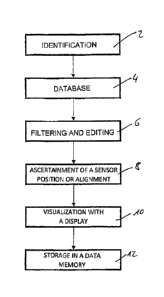
Initially, there is identification 2 of the traffic
route to be monitored. Here, information items of the
data processing device are provided in a first method
step, the traffic route to be monitored or the part of
the traffic route to be monitored being able to be
identified uniquely from said information items. The
information items about the traffic route identified
thus are subsequently transmitted to a database 4, from
which information items about the traffic routes to be
monitored or the traffic route to be monitored are
CA 02956340 2017-01-26
WO 2016/015857 - 12 -
PCT/EP2015/001548
queried and provided. These data are subjected to
filtering and editing 6 in the next method step. By way
of example, this is necessary when using the "open
street map" database because the data are not available
in the desired format.
Subsequently, there is ascertainment 8 of a possible
intended position and/or intended alignment. A
multiplicity of individual method steps may be
contained in this method step. Thus, use may be made of
iterative methods in order to find the ideal intended
position and intended alignment for the ideal number of
required sensors. Here, in particular, entered and
predetermined boundary conditions are used as criteria
as these need to be observed.
Subsequently, there is a visualization 10 of the at
least one intended position and/or intended alignment,
for example on a display or any other indication
device. By way of example, this may be brought about by
virtue of ascertained capture regions being depicted in
a manner superposed on an aerial image or a map. This
allows a user to particularly easily identify what
region of the traffic route is monitored by which one
of the optionally plurality of sensors and whether all
boundary conditions which are of interest to the user
are observed and satisfied. Subsequently, there is
storage 12 in a data memory of the sensor of the data
and information items about intended position and
intended alignment and the required information items
about the part of the traffic route to be monitored.
Hence, the sensor is equipped with all information
items required to ensure the full functionality and
capability of the sensor.
CA 02956340 2017-01-26
WO 2016/015857 - 13 -
PCT/EP2015/001548
List of reference signs
2 Identification
4 Database
6 Filtering and editing
8 Ascertainment
Visualization
12 Storage