Note: Descriptions are shown in the official language in which they were submitted.
CA 02960826 2017-03-09
WO 2016/040680 PCT/US2015/049488
SYSTEMS AND METHODOLOGIES FOR VALIDATING THE
CORRESPONDENCE BETWEEN AN IMAGE AND AN ASSET
CROSS-REFERENCE TO RELATED APPLICATION
[0001] This application claims the benefit of priority from U.S.
Provisional Patent
Application No.62/048,506, filed September 10, 2014, having the same title,
and having
the same inventor, and which is incorporated herein by reference in its
entirety.
FIELD OF THE DISCLOSURE
[0002] The present disclosure relates generally to image verification, and
more
particularly to systems and methodologies for validating the correspondence
between an
image and an asset.
BACKGROUND OF THE DISCLOSURE
[0003] Establishing the fair market value of assets, such as real estate,
is an important
aspect of various transactions, including the purchase or sale of property,
financing
(including mortgages and refinancing), and insurance. Typically, this process
involves
first identifying other properties whose fair market value has been
established (often
through recent sales), and which are considered to be comparable to the
property being
evaluated. These so-called "comparables" may then be utilized to infer the
fair market
value of the property under consideration.
[0004] Whether a given property is a "comparable" to a property being
evaluated is
frequently subject to interpretation. However, in the context of real estate
appraisals, an
appraiser typically looks for properties in the same geographic area which
have been the
subject of recent sales (typically within 3-6 months of the date of the
appraisal). In order
to lend some level of transparency to the procedure, the file associated with
an appraisal
will typically include images of the property that is the subject of the
appraisal, as well as
1
CA 02960826 2017-03-09
WO 2016/040680 PCT/US2015/049488
images of the comparable properties that were used as a basis for the
appraisal.
Consequently, a party wishing to use the appraisal or to verify its accuracy
can use these
images to understand the basis for the appraised value, and to identify issues
that might
call into question the accuracy of the appraisal.
[0005] By way of example, such images may indicate that one or more of the
comparables is of clearly higher quality than the subject property (for
example, a
comparable may have a stone exterior, while the subject property has vinyl
siding), which
could suggest that the appraised value of the subject property may be overly
generous.
Similarly, these images may reveal the presence of recent water damage to the
subject
property, which may need to be accounted for in the appraised value.
BRIEF DESCRIPTION OF THE DRAWINGS
[0006] FIGs. 1-14 are screenshots from a particular, non-limiting
embodiment of a
software application in accordance with the teachings herein.
SUMMARY OF THE DISCLOSURE
[0007] In one aspect, a method for performing an appraisal on an asset is
provided.
The method comprises (a) providing software, installed on a mobile technology
platform
associated with a user, which includes image capture and location awareness
functionalities; (b) obtaining a set of comparable assets to be used as a
basis for
establishing the appraisal value of the asset; (c) repeating, until n images
have been
captured, where n 1, the steps of (i) receiving, from the user, a request
to capture an
image with the software of a target asset selected from the group consisting
of the asset
and the comparable assets, (ii) determining the current location of the user
with respect to
a geofence associated with the target asset, and (iii) if the user is within a
distance d of
the target asset or is within a geofence associated with the target asset,
then capturing the
image, and otherwise denying the request; and (d) using the n images to
determine an
appraisal value of the asset.
2
CA 02960826 2017-03-09
WO 2016/040680 PCT/US2015/049488
[0008] In another aspect, a method is provided for capturing images of an
asset. The
method comprises (a) providing software, installed on a mobile technology
platform
associated with a user, which includes image capturing and location awareness
functionalities; (b) receiving, from the user, a request to capture an image
of the asset
using the software; (c) determining the current location of the user with
respect to a
geofence associated with the asset; and (d) if the user is within a distance d
of the asset or
is within a geofence associated with the asset, then granting the request, and
otherwise
denying the request.
[0009] In a further aspect, a method is provided for validating images used
to assess
the value of an asset. The method comprises (a) obtaining an image of each of
a plurality
of comparable assets, wherein each image has a dataset associated therewith
which
includes locative data specifying the location of the comparable asset; (b)
determining the
physical location of each of the plurality of comparable assets by
ascertaining the
geospatial coordinates of an address associated with each of the plurality of
comparable
assets; (c) for each of the plurality of comparable assets, comparing the
determined
location of the comparable asset to the locative data specified for the
comparable asset in
the associated dataset; and (d) if the determined location of the comparable
asset is within
a predefined distance of the location specified for the comparable asset in
the associated
dataset, then marking the image of the comparable asset as validated, and
otherwise
flagging the image of the comparable asset as being potentially invalid.
3
CA 02960826 2017-03-09
WO 2016/040680 PCT/US2015/049488
[0010] In still another aspect, a method is provided for validating an
image as
corresponding to an asset. The method comprises (a) obtaining an image for
each
member of a set of N assets, where N> 1, and wherein, for the kth asset, where
k 8 N, the
image of the kth asset has a kth dataset associated therewith which includes
locative data
specifying the location of the kth asset; and (b) for at least one asset Ai 8
{A1, ..., AN},
validating the image of the asset by (i) determining the location of the th
asset by
ascertaining the geospatial coordinates of a physical address associated with
the ith asset,
(ii) comparing the determined location of said ith asset to the locative data
specified for
the ith asset in the ith dataset, and (iii) if the determined location of the
ith asset is within a
predefined distance of the location specified for the ith asset in the ith
dataset, then
marking the image of the ith asset as validated, and otherwise flagging the
image as being
potentially invalid.
[0011] In yet another aspect, a method is provided for validating an image
as
corresponding to an asset. The method comprises (a) obtaining an image of a
first asset
having a first dataset associated therewith, said first dataset including
locative data which
specifies the location of the first asset; (b) determining the location of the
first asset by
ascertaining the geospatial coordinates of a physical address associated with
the first
asset; (c) comparing the determined location of said first asset to the
locative data
specified for the first asset in the first dataset; and (d) if the determined
location of the
first asset is within a predefined distance of the location specified for the
first asset in the
first dataset, then marking the image of the first asset as validated, and
otherwise marking
the image of the first asset as being potentially invalid.
4
CA 02960826 2017-03-09
WO 2016/040680 PCT/US2015/049488
[0012] In still another aspect, a method is provided for validating the
images used to
assess the value of an asset. The method comprises (a) obtaining a first image
of an asset
having a first dataset associated therewith, said first dataset including
locative data which
specifies the location of the asset; (b) obtaining a second image of a
comparable asset
having a second dataset associated therewith, said second dataset including
locative data
which specifies the location of the comparable asset; (c) determining the
location of a
subject asset by ascertaining the geospatial coordinates of a physical address
associated
with the subject asset, wherein the subject asset is selected from the group
consisting of
said asset and said comparable asset; (d) comparing the determined location of
said
subject asset to the locative data specified for the subject asset in the
first or second
datasets; (e) if the determined location of the subject asset is within a
predefined distance
of the location specified for the subject asset in the first or second
datasets, then marking
the image of the subject asset as validated, and otherwise marking the image
of the as
being potentially invalid.
[0013] In another aspect, a tangible, non-transient medium is provided
which
contains suitable programming instructions which, when executed by one or more
computer processors, executes or implements any of the foregoing methods.
DETAILED DESCRIPTION
[0014] Although systems and methodologies for conducting appraisals are
well
known and have been used for some time, many of these systems and
methodologies are
susceptible to human error or fraud. These issues are especially problematic
when the
appraisal will be relied upon for insurance purposes, since in this context,
such errors or
fraud can quickly lead to significant losses on the part of the insurance
company or its
underwriters.
[0015] For example, an insurance company may wish to grant an insurance
policy to
a property owner to protect the owner against loss or damage to the property
(e.g., by
covering replacement costs), or to protect the investment of the owner in the
event that
the market value of the property declines between the time the property is
purchased and
CA 02960826 2017-03-09
WO 2016/040680 PCT/US2015/049488
the time the property is sold. In either case, the fair market value of the
property is
typically crucial to establishing the risk that the insurer is undertaking,
and hence is
commonly utilized as an important consideration in structuring the insurance
policy and
in determining the associated premium.
[0016] However, it is frequently the case that the insurance company will
not have a
local presence in the area in which the property resides. Consequently, the
insurance
company may have to rely on one or more local agents in order to obtain images
of the
subject property and to identify reasonable comparables that may be utilized
to ascertain
the fair market value of the property to be insured.
[0017] Through human error, fraud or incompetence, the images provided by
the
local agent for this purpose may not correspond to the properties they purport
to
correspond to. For example, an image presented as corresponding to a property
at a
given address may actually be an image of a different property, or the images
may be out
of date (that is, they may not represent the current condition of the subject
property
and/or one or more of the comparables). Since the insurance company is not
itself local
to the property in question, it is at a disadvantage in being able to identify
such
discrepancies. This may result in inaccurate appraisal values or an incomplete
understanding of the risks being assumed, which may cause the insurer to incur
heavy
losses in the transaction.
[0018] A further shortcoming of the manner in which appraisals are
currently
conducted has to do with file management. In a typical appraisal, it is
desirable for the
appraiser to take several pictures of the subject property and of each
comparable. Having
multiple pictures is useful to obtaining a clear understanding of any
significant features
that may positively or negatively affect the value of the subject property or
its
comparables. Consequently, on a given day, an appraiser may capture a large
number of
images for use in preparing multiple appraisals.
[0019] However, the large number of images commonly captured by an
appraiser
presents significant file management issues. In particular, each of these
images must be
properly associated with the property to which they correspond. This may
involve the
6
CA 02960826 2017-03-09
WO 2016/040680 PCT/US2015/049488
time consuming process of transferring the images from an imaging device (such
as a
camera or mobile phone) to one or more files on a computer, and then uploading
the
images to a site associated with an appraisal company or a client thereof.
During this
process, images may be lost, corrupted or misfiled. This process must be
repeated each
time additional images for a property are captured.
[0020] There is thus a need in the art for systems and methodologies of
validating the
correspondence between an image and an asset. In particular, there is a need
in the art for
systems and methodologies which ascertain that the images associated with a
property or
its comparables are recent, and are actually of the property they purport to
be of There is
also a need in the art for systems and methodologies of capturing images of
assets, or for
processing the captured images, that efficiently catalog the captured images
such that the
images are grouped by location (e.g., such that all images of an asset at a
particular
location are grouped together, regardless of the sequence in which the images
were
captured or the specific time at which they were captured), and makes the
images readily
available to any parties of interest. These and other needs may be met with
the systems
and methodologies described herein.
[0021] It has now been found that the foregoing needs may be met by the
systems
and methodologies disclosed herein. In a preferred embodiment, these systems
and
methodologies leverage a software program that validates the correspondence
between an
image and an asset, either by establishing that correspondence at the time of
image
capture and then maintaining it, or by verifying the correspondence for
previously
captured images. The software program may take the form of an application
installed on
a mobile technology platform that is associated with a party who is
responsible for
capturing images of an asset (or of asset comparables), and/or as a
distributed application
with a server component that interfaces with each of a plurality of local
instances of a
client component installed on each of a plurality of mobile technology
platforms.
[0022] The software may utilize its own location awareness capabilities, or
those of a
host device (such as, for example, GPS tracking or cell tower triangulation
algorithms
available on most mobile technology platforms), to record the location and
time at which
7
CA 02960826 2017-03-09
WO 2016/040680 PCT/US2015/049488
an image was captured, and/or to control the image capture process. For
example, in
some embodiments, the software may prevent image capture, or may prevent the
association of an image with a target asset (which will typically be an asset
or one of its
comparables), until the software detects that the user is within a certain
proximity to the
target asset which is to be associated with the image, or determines after the
fact that the
user was within such proximity at the time of image capture. In some
embodiments, such
proximity may be assessed based on the user's location (or more specifically,
the location
of a mobile technology platform associated with the user) with respect to one
or more
geofences defined around the target asset.
[0023] In some embodiments, the software may also be equipped with an
override
function that allows a user to take an image outside of a geofence (or outside
of a
specified distance from a geofence), or to otherwise associate an image with
an asset or
target in situations where the software would not otherwise make such an
association.
For example, a user may wish to take an image of a property from a significant
distance
away to show, for example, that the property is nestled at the foot of a
mountain.
However, the images will preferably be flagged in such situations so that the
association
can be readily reviewed by any interested parties so that the validity of the
association
may be readily ascertained.
[0024] An image captured in accordance with the foregoing process may be
tagged
(preferably during capture, although in some instances, the tagging may occur
at a later
time) with the recorded locative and/or temporal data as, for example, by
recording this
information in the metadata associated with the image. The software may then
use this
data to sort the captured images as, for example, by placing images with the
same or
similar locative data in a folder associated with a target asset residing at
that location
(e.g., "4512 Court of St. James"). As a result of the foregoing, any human
error or fraud
which might otherwise be involved in creating an association between an image
and the
time or location at which it was captured may be reduced or eliminated.
[0025] In some embodiments, the software may be provided with suitable
intelligence to make default associations. For example, the software may
recognize that
8
CA 02960826 2017-03-09
WO 2016/040680 PCT/US2015/049488
an image has been captured at a location or geofence which already has at
least one
image associated with it. In such cases, the software may automatically
associate the
captured image with the existing location or geofence, possibly subject to an
override
option presented to the user (for example, the user may be queried to confirm
the
proposed association, or the proposed association may be indicated through a
suitable
visual cue so that the user is alerted to it and can change the association,
if need be). The
software will also preferably be equipped with suitable intelligence to
recognize that the
user has not left a location or geofence, and will thus preferably continue to
associate
captured images with the location or geofence until the user has exited that
location or
geofence, or has instructed the software to make a different association.
[0026] In some embodiments, when an image has already been associated with
a
target asset, the software may verify that association by comparing a first
set of locative
and/or temporal data associated with the image with a second set of locative
and/or
temporal data associated with the purported location of the target asset. The
locative data
in the second set of data may be obtained, for example, by determining the GPS
coordinates of the physical address of the property which is purportedly shown
in the
image or by utilizing other suitable location determining means. If the
locative data from
the first and second sets do not agree within a specified level of variance
(or, in some
embodiments, if the locative data from the first and second sets do not fall
within the
same geofence), then the image may be flagged as not corresponding to the
property at
the given address, or as requiring verification of the purported location at
which the
image was captured. Similarly, if the temporal data in the first and second
data sets does
not agree within a specified level of variance (e.g., 1 week, 1 month, 3
months, 6 months,
a year, or some other suitable time interval or level of variance), then the
image may be
flagged as not being sufficiently recent, or as requiring verification of the
purported time
at which the image was captured.
[0027] The systems and methodologies disclosed herein may be further
understood
with reference to the following particular, non-limiting example. In this
example, a
software client is provided in the form of a mobile application installed on a
mobile
9
CA 02960826 2017-03-09
WO 2016/040680 PCT/US2015/049488
technology platform associated with a user, and is used in conducting an
appraisal on real
estate. However, one skilled in the art will appreciate that a software system
of this type
may take various forms, and that the software and associated systems and
methodologies
may be readily applied to various other types of other assets. Thus, for
example, these
systems and methodologies may be applied to various types of real estate,
personal
property and chattel including, without limitation, commercial and residential
real estate,
buildings or property; vehicles such as, for example, automobiles, trucks,
motorcycles
and watercraft (including, for example, boats and jet skis); valuables
(including, for
example, paintings, coin or stamp collections and historical artifacts); and
the like.
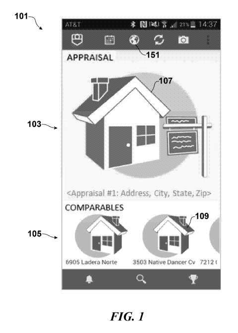
[0028] FIG. 1 depicts the main screen 101 rendered by the software upon
launch. As
seen therein, the screen 101 in this embodiment includes an 'Appraisal'
section 103 and a
'Comparables' section 105 as the two main viewable areas. The 'Appraisal'
section 103
includes an icon 107 (or placeholder image) of the property for which the home
appraisal
is being conducted, and the "Comparables" section 105 includes icons 109 or
placeholder
images of each of the comparables that are to be used as the basis for the
appraisal.
[0029] As images are captured with the software described herein (the image
capture
process is described in greater detail below), the icons 107, 109 or
placeholder images are
preferably replaced with actual images (or thumbnail versions thereof) of the
corresponding properties. Similarly, if images of the property or one or more
of its
comparables already exist, the icons 107, 109 or placeholder images may be
prepopulated
with those images (or thumbnail versions thereof). FIG. 4 provides an example
of how
the screen of FIG. 1 might appear after it has been populated with images of
actual
properties in the foregoing manner.
[0030] As seen in FIG. 4, each property is associated with a number
(preferably three
to five) of comparables 109, images and addresses of which are listed in the
"Comparables' section 105. In the particular embodiment depicted in FIG. 4,
the
comparables in the "Comparables' section 105 are listed in a thumbnail strip
which is
scrollable to the left or right, and the image folder for each of the
comparables (which
contains all of the captured images of that comparable) is accessible by
selecting the
CA 02960826 2017-03-09
WO 2016/040680 PCT/US2015/049488
corresponding image of the comparable in the "Comparables' section 105. In
this or
other embodiments, the comparables may also be accessible via hyperlinks,
menus,
through keystroke commands, or by other suitable means.
[0031] The address fields in the "Comparables' section 105 may be populated
in
various ways. For example, the addresses of the comparables may have been pre-
selected by a third-party (in which case the address may already appear
beneath the house
icon before any images have been captured), or the appraiser may select or
specify an
address for the property in this field, based on the appraiser's knowledge of
the local
market for the property. Preferably, whenever the property is loaded that is
the subject of
the appraisal, the comparables associated with that property load alongside
it.
[0032] If the comparables have not been pre-loaded, then the appraiser may
select
one of the icons 109 in the "Comparables" section 105 in order to take a
photo. In the
particular embodiment depicted, there are five such icons 109, although
various
embodiments may allow a user to specify the number of comparables to be
utilized
(either for a specific appraisal or as a general setting). It will, of course,
be appreciated
that the systems and methodologies disclosed herein are not limited to any
particular
number of comparables, and may thus allow for the use of virtually any number
of
comparables.
[0033] Various means may be utilized to capture images or to populate the
pages of
the software with images, some of which are described in greater detail below.
Preferably, however, the software described herein is equipped with imaging
functionalities that are configured so that they may only be activated or
utilized when a
user is within a predetermined proximity of the property to be imaged, or is
within a
geofence associated with that property. In an especially preferred embodiment,
the
appraiser must be within the active geofence of the property in question or
within a given
distance of that geofence in order to associate photos with that particular
property. When
these imaging functionalities are utilized, the captured images are stored in
folders
associated with each property, and the screen depicted in FIG. 1 is populated
with
samples of the captured images.
11
CA 02960826 2017-03-09
WO 2016/040680 PCT/US2015/049488
[0034] Various means may be utilized with the systems and methodologies
disclosed
herein to assign an appraiser to an appraisal project. For example, in some
embodiments,
sets of homes may be pre-loaded or periodically uploaded to a given
appraiser's account
(and hence to the software client or instance of the software application
which is
associated with the appraiser or the appraiser's mobile technology platform),
and the
appraiser may then conduct appraisals on these homes over a certain period of
time. For
example, these homes may be assigned to the appraiser by a business entity
with which
the appraiser is associated (e.g., as an employee or independent contractor).
In some
embodiments, a deadline may be specified by which the appraiser is required to
have
completed, or at least started, the appraisal, and the appraisal project may
be assigned to
another appraiser if this deadline is not met.
[0035] Alternatively or in addition, an automatic feed may be utilized
which fetches
addresses of properties in real-time from a service that caters to users or
entities
interested in obtaining appraisals of properties, and/or to appraisers
interested in
conducting appraisals. The service may be available, for example, on a
subscription basis
to the users and/or appraisers. After a user specifies an address for an asset
(or otherwise
provides information from which such an address may be ascertained), a
suitable
appraiser may be selected to conduct the appraisal on the asset based on
various criteria.
For example, a suitable appraiser may be selected based on the appraiser's
proximity to
the property for which an appraisal has been requested, or based on the
workload of an
appraiser (e.g., how busy the appraiser is, in order to facilitate a faster
response time), or
based on the expertise or experience of a given appraiser with assets of the
type for which
an appraisal is being sought. If proximity is utilized as a criteria for
selecting an
appraiser for an appraisal project, such proximity may be determined from the
appraiser's
business address or region, or by echoing back the geo-locations of appraisers
to an
appraisal service for this purpose.
[0036] In some embodiments (and possibly for an up-charge), an appraiser
who
subscribes to an appraisal service or is an employee or independent contractor
working
for the company operating the service, may designate a particular geographic
region the
12
CA 02960826 2017-03-09
WO 2016/040680 PCT/US2015/049488
appraiser is interested in working in or is licensed or authorized to work in.
The service
may then preferentially pair the appraiser up with assets in this particular
area/location.
Similarly, an appraiser who subscribes to the service may designate a
particular asset type
which the appraiser is interested in working with or is licensed or authorized
to work with
(in the context of the present example, the asset type could be, for example,
a particular
type of house, a price range, or a set of neighborhoods). The service may then
preferentially pair the appraiser with assets of the particular type
specified.
[0037] In a typical appraisal, significantly more images will be captured
of the
property being appraised than of any of its comparables. However, the systems
and
methodologies disclosed herein may provide the ability to take capture as many
images
as is necessary or desirable for either the target asset or its comparables.
The systems and
methodologies disclosed herein may also provide the ability to sort or
prioritize the
images for viewing, to use as representative images, or for other purposes.
[0038] In a preferred embodiment, as soon as a captured image is uploaded,
the
service will perform an address look-up based on GPS information or on other
captured
locative data, and will suggest one or more addresses for the home appraiser
to choose
from. If the service is not able to ascertain a street address to associate
with a
comparable, or if the actual address is not offered as a choice, the user may
be afforded
the option of manually entering such information in an address field. The GPS
location
information or other locative data is preferably still associated with this
manual entry,
although it may be flagged for possible third-party review or later reference.
This
locative information is preferably recorded in the metadata associated with
the captured
image.
[0039] In a preferred embodiment of the software, once an appraiser begins
an
appraisal, the appraisal must be completed before another appraisal can be
started. If an
appraiser has to cancel the appraisal for any reason, the appraiser may forego
any revenue
associated with the appraisal, and the appraisal request may be returned to
the top of the
queue for assignment to another appraiser. In the event of cancellation, the
appraiser will
13
CA 02960826 2017-03-09
WO 2016/040680 PCT/US2015/049488
preferably be prompted to provide a reason for the discontinuation of the
appraisal, and
these reasons may be tracked (e.g., for quality control or fraud prevention
purposes).
[0040] The foregoing notwithstanding, some embodiments of the systems and
methodologies disclosed herein may allow appraisals to be accomplished in a
piecemeal
fashion so that, for example, target properties may be imaged based on their
proximity to
each other, rather than the appraisal they relate to. In such embodiments, the
software
will preferably sort the captured images into appropriate files so that they
are associated
with the proper appraisal project, or will mark them appropriately so that
such an
association may be made later if desired.
[0041] When an image of a property being appraised has been pre-loaded,
selection
of the associated for-sale icon in FIG. 1 launches the screen 121 depicted in
FIG. 2. This
screen 121 includes a map 123 having a pin 125 thereon which indicates the
location of
the property. Selection of the property address (in the particular embodiment
depicted,
this address is "1440 Mount Larson Rd") preferably launches a script which
displays
directions from the appraiser's current location to the property in question.
The map 123
preferably includes a bird's eye view of the property, and may be equipped
with pinch or
zoom functionalities (or similar or associated gestures, keys or keystrokes)
to allow the
user to shrink or enlarge (see FIG. 3) the view. In the particular embodiment
depicted, if
the user is in sufficiently close proximity to the property, their present
location appears
on the screen, and is designated by a dot 127 or other icon which is super-
imposed on the
map 123.
[0042] As noted above, the software application is preferably equipped with
suitable
image capture functionalities to allow a user to capture images of a property,
it being
understood that the software application may also be equipped to capture
videos, IR
signatures, audio files, or other files, data types or media which may be
associated with
the property. However, these functionalities are preferably available only
when the user
is within the property's active geo-fence, and are preferably otherwise
disabled. Hence,
for example, the user's ability to associate images with a particular property
may be
limited to such times as the user is within the property's geo fence.
14
CA 02960826 2017-03-09
WO 2016/040680 PCT/US2015/049488
[0043] In the preferred embodiment, as images are captured, they appear in
real time
over a network that the mobile technology platform is in communication with.
Such a
network may, for example, be the Internet, and the photos may appear in real
time on a
website. This website preferably has controlled access so that only authorized
parties
may view or access the images.
[0044] Preferably, as images are captured of a target asset (which may be a
property
being appraised or any of its comparables), the most recently captured image
becomes the
cover photo for the image folder associated with the target asset. This
situation
preferably persists unless and until the user designates a cover photo
manually.
[0045] As seen in FIG. 7, in the particular embodiment depicted, the images
in the
image folder appear in a 3 x n array which is scrollable from top to bottom,
and which
spans all of the photos which have been associated with the target property.
Preferably,
selection of any individual photo by the user launches a full-screen "Gallery"
mode,
where any photo in the array may be commented on, shared, flagged, modified
(for
example, by adjusting exposure, saturation, or other features of the image),
or subjected
to other suitable actions. The Gallery mode also allows the user to set a
cover photo for
an image folder (e.g., by selecting the SetCoverPhoto icon within the
"Gallery" view of
the property).
[0046] After images are captured of the property which is the subject of an
appraisal,
returning to the home screen will display a large image of the property in
place of the
"home for sale" icon. As noted above, the user may change this image at any
time by
selecting a different image to be used as the cover from the image folder
within the
Gallery view.
[0047] The appraiser may now select one of the home icons in the
"comparables"
strip to begin taking photos of the comparable. If an address for each
comparable has
been pre-populated, the appraiser may click on the "home for sale" icon to see
a birds'
eye map view of the type shown in FIG 2 in order to navigate to the property
or to
determine whether the user has entered the property's active geofence. If the
user is
within the active geofence of the property, the user may begin capturing
images of the
CA 02960826 2017-03-09
WO 2016/040680 PCT/US2015/049488
property. As with the images of the property which is the subject of the
appraisal, these
images preferably upload in real time to the service.
[0048] After one or more images have been associated with a comparable, the
"home" icon in the comparables section 105 on the main screen is replaced with
a
thumbnail version of one of the images just captured. Clicking on this
thumbnail now
displays all of the applicable property images in the same 3xn fashion as
described earlier
for the target home being appraised. A cover photo representative of the
"comparable"
property may also be selected and set by the user in the same manner described
above for
the property which is the target of the appraisal.
[0049] As noted above, FIG. 4 depicts an example of the screen of FIG. 1
after all of
the image fields have been populated. Selection of the globe icon 151 in the
header of
FIG. 4 displays the map of FIG. 5. This map is zoomed out just enough to show,
on a
single screen, the location of the property being appraised and the location
of each of the
comparables. In the particular case depicted in FIG. 5, the home being
appraised (marker
125) and five comparables (markers 126) are shown.
[0050] Selection of a comparable marker 126 launches a page 128 of the type
depicted in FIG. 3 in which the comparable selected is centered on a map. The
user may
re-center the map or zoom in or out to provide a desired perspective of the
comparable.
[0051] As seen in FIG. 6, selection of a property's location marker (125 or
126)
displays a balloon 131, which references (a) the property's physical address,
(b) the party
that ordered the appraisal, and (c) the length of the appraisal (from start to
finish). In
some embodiments, other information may be included such as, for example, the
amount
of the home loan amount being sought or the intended sales price (if either is
applicable).
[0052] Selection of the property balloon 131 preferably brings the user to
the 3xn
view 133 of all the thumbnail images for that particular property, as seen in
FIG. 7. The
3xn view 133 may become a scrollable (that is, the user may be given the
ability to
advance through them with a swipe, through selection of a scroll bar, or by
other suitable
means) lx1 or 2x2 view if the number of photos taken for a comparable home is
four or
less (as is often the case with comparables in real estate appraisals).
16
CA 02960826 2017-03-09
WO 2016/040680 PCT/US2015/049488
[0053] As seen in FIGs. 7-9, the user has the ability to save any or all of
the images
for the appraisal and its comparables to one of a number of different third-
party storage
services. For example, in a preferred embodiment, when an image (or images)
from the
3xn array of FIG. 7 is long pressed and the cloud icon is simultaneously or
subsequently
selected, the software launches the dialog box 135 shown in FIG. 8, which
presents the
user with various cloud storage options. If the "Dropbox" option is selected
(e.g., by
selecting the corresponding icon), a folder is created entitled "<address of
appraisal>",
which has sub-folders in the name of the addresses of the individual "comp"
properties.
As seen in FIG. 9, a pop-up screen 137 is then launched which notes the
success of the
action and prompts the user with a suitable prompt 139 to check their email
(e.g., for the
hyperlink to the DropBox file containing the saved images). Of course, one
skilled in the
art will appreciate that various other file storage, file sharing or file
transfer services may
be utilized in place of, or in addition to, the Dropbox service.
[0054] As seen in the sequential screenshots depicted in FIGs. 10-13, the
user also
has the ability to print any or all of the images for the appraisal and its
comparables to a
nearby print service from the 3xn view 133. For example, when an image from
the 3xn
array 133 of FIG. 7 is selected for printing, the software launches the dialog
box 135
shown in FIG. 11 (and identical to that of FIG. 8), which presents the user
with print,
save or storage options. In a preferred embodiment, and in the case of some of
the print
services, nearby store locations (such as Walgreens, K-mart or CVS) which
offer these
services may be displayed, based on their proximity to the user. Since most of
these
print-on-demand services can fulfill a print order in minutes, a user can
quickly reduce a
desired number of electronic images to hardcopy if necessary or desired.
[0055] The dialog box 141 of FIG. 12 (which, in the particular embodiment
depicted,
is a dialog box of an external software program or resource called by the
software
described herein) provides order options which govern hard copies that are
ordered of
any images. This dialog box includes, for example, means for selecting photo
size and
quantity. It also allows the user to apply any applicable coupons to the
transaction, and
notes the associated cost of the transaction.
17
CA 02960826 2017-03-09
WO 2016/040680 PCT/US2015/049488
[0056] The dialog box 143 of FIG. 13 (which appears after selection of the
"Next"
tab in FIG. 12) provides a listing of selectable locations at which the
printed photos may
be picked up. This listing also notes the name and address of each
establishment, its
distance from the current location of the user, and the estimated time at
which the photos
will be ready for pickup at that establishment.
[0057] Any of the images from the appraised property or its comparables may
be
viewed in Gallery mode by, for example, selecting its thumbnail in the 3xn
view. The
user may browse back or forth through the images using navigational techniques
as are
known to the art including, for example, by swiping across the screen. By
utilizing the
toolbar 151 at the footer of the Gallery view (see FIG. 10), the user may make
notes or
comments on any individual photo, or may share an individual photo by email,
text,
social media, Twitter, FB, g+, or other such services.
[0058] The toolbar 151 is preferably customizable, and may include icons to
highlight issues such as, for example, safety issues, items in disrepair, a
high dollar
fixture, appliances or other hardware, and other items which may need to be
brought to
the attention of the buyer or seller. For example, these tools may be utilized
to note
something which is out of compliance with applicable codes.
[0059] The software, systems and methodologies disclosed herein may also be
equipped with a Chat mode. In particular, since all photos are uploaded to the
service in
real-time, an opportunity exists to provide immediate feedback to the
property/home
appraiser with regard to the quality of the images and/or completeness of the
survey.
Preferably, the Chat mode will only work while a user is on-property, or
within some
distance of the property (e.g., within a geofence associated with the
property, or within a
certain distance of the geofence), thus making it property-specific. This may
minimize
mistakes about which home and/or photos are being discussed if an issue or
concern
arises with regard to any of the photos making up an appraisal.
[0060] The software and systems disclosed herein may also be equipped with
a
"Notifications" icon located in the footer. This icon may be utilized to
indicate, for
18
CA 02960826 2017-03-09
WO 2016/040680 PCT/US2015/049488
example, whether any notifications have been received with respect to one or
more of the
images.
[0061] The systems and methodologies disclosed herein may be further
understood
with reference to the following additional particular, non-limiting embodiment
and
application.
[0062] An insurance company wishing to establish the fair market value of a
residence for insurance purposes contracts an appraiser local to the residence
to conduct
an appraisal of the property. The insurance company provides the appraiser
with a
software application in the form of a software client which is installed on a
mobile
technology platform (e.g., a mobile phone, laptop or PDA) associated with the
appraiser.
[0063] The software is equipped with suitable image capture capabilities.
As the
appraiser captures images, the software records the time at which the image
was captured
and the GPS coordinates or other temporal or locative data which specifies the
time and
location at which the image was taken. If the location is a new location
(i.e., the software
determines that no other images have been taken at that location), the
software queries
the user for a location identifier (typically a name or physical address)
which corresponds
to the location at which the images are being taken. If the location is within
a predefined
distance of the location associated with an existing folder (this distance is
typically just
large enough to account for normal variances in location determination), the
software
saves the image to the folder associated with that location.
[0064] As a result of the foregoing, the images captured by the appraiser
are uploaded
in real time to a server which establishes whether or not a captured image can
be
associated with a particular property. The captured images are properly sorted
by
location so that, for example, all of the images of the residence are placed
in a folder
associated therewith, and all of the images of each comparable are likewise
placed in a
folder associated with the comparable. The software may then upload the sorted
images
to a server associated with the insurance company. Such uploading may occur at
the
command of the appraiser (i.e., after the appraiser indicates that image
capture is
complete), or periodically as a background process.
19
CA 02960826 2017-03-09
WO 2016/040680 PCT/US2015/049488
[0065] The above description of the present invention is illustrative, and
is not
intended to be limiting. It will thus be appreciated that various additions,
substitutions
and modifications may be made to the above described embodiments without
departing
from the scope of the present invention. Accordingly, the scope of the present
invention
should be construed in reference to the appended claims.