Note: Descriptions are shown in the official language in which they were submitted.
BOREHOLE SHAPE CHARACTERIZATION
FIELD OF THE DISCLOSURE
[0] The present disclosure relates generally to borehole drilling, and more
particularly to
borehole shape characterization.
BACKGROUND
[1] Fluids (e.g., oil, water, gas) trapped in geologic formations are often
recovered via
a well, or borehole, drilled into the formation. A drilling operation
generally utilizes a drill
bit attached, as part of a bottom-hole assembly (BHA), to a drill pipe
suspended from a
surface facility. Drilling mud may be circulated through the drill pipe, drill
bit, and an
annulus formed between the pipe and borehole wall to cool the drill bit and
carry drill
cuttings back up to the surface.
[2] During drilling, it is often desirable to monitor the properties of the
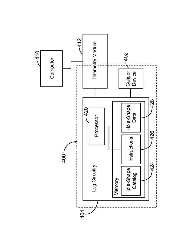
borehole and
surrounding formation and fluids. For this purpose, well logging tools may be
integrated into
the BHA, acquiring data in real time (or near real time) at increasing
borehole depths as the
drill bit advances; this technique is known in the industry as "logging while
drilling" (LWD)
or "measuring while drilling" (MWD). Different tools may be used for different
types of
measurements: for example, density and neutron tools may provide information
about the
porosity of the formation (allowing inferences about the probability of
finding oil vs. gas);
gamma-ray tools may help distinguish between different types of rock (e.g.,
sandstone and
limestone); resistivity tools may use electrical resistivity measurements to
determine whether
water or hydrocarbons are present; sonic tools may measure the speed of sound
in the rock,
which is useful in planning fracking operations; and caliper tools may
determine the size and
shape of the borehole. Hole shape information may be used, for example, by
drilling
engineers to compute the volume of cement required to complete the well, by
reservoir
engineers and geologists to understand downhole stresses and the orientation
of break-outs
and fractures, and by petrophysicists to correct formation evaluation
measurements
performed with other tools (e.g., resistivity and neutron-porosity tools) for
the effect of
standoff (i.e., the distance of the tool from the borehole wall).
[3] The data acquired downhole by the LWD tools may be transmitted in
(near) real
time up to the surface for processing and evaluation. From borehole depths
beyond the
practicable reach of wired communication, this can be achieved, e.g., via mud
pulse
telemetry, a technique that involves imparting pressure variations that encode
the data in
binary form onto the drilling mud. This mechanical form of transmission is
subject to
significant bandwidth limitations; in many implementations, data transmission
rates are in the
1
CA 2964238 2019-01-22
range from only three to ten bits per second. Accordingly, different logging
tools may
compete for bandwidth, and the information update rate provided by a given
tool may be
throttled to allow other data to be transmitted between successive updates.
SUMMARY
[3a] In accordance with a broad aspect, there is provided a method. The
method
comprises measuring a shape of a borehole with a well-logging tool to provide
a measured
borehole shape, using a processor and associated memory located downhole, (i)
comparing
the measured borehole shape against a catalog of hole shapes stored in the
downhole memory
so as to identify a matching catalog shape, and (ii) determining a size
parameter associated
with the measured borehole shape, and modifying a behavior of a downhole tool
based on at
least one of the matching catalog shape or the size parameter.
[3b] In accordance with another broad aspect, there is provided a well-
logging tool.
The well-logging tool comprises a caliper device for measuring a borehole
shape to provide a
measured borehole shape, and in communication with the caliper device, a
processor and
memory, the memory storing a catalog of hole shapes and instructions which,
when executed
by the processor, cause the processor to (i) compare the measured borehole
shape against the
catalog of hole shapes so as to identify a matching catalog shape, and (ii)
compute a size
parameter associated with the measured borehole shape, and (iii) modify a
behavior of a
downhole tool based on at least one of the matching catalog shape or the size
parameter.
BRIEF DESCRIPTION OF THE DRAWINGS
[4] FIG. IA is a schematic diagram of a drilling system adapted for MWD/LWD
operations, in accordance with various embodiments.
[5] FIG. l B is a cross-sectional view of a borehole and a logging tool
used therein,
illustrating the measurement of standoff data in accordance with various
embodiments.
[6] FIGS. 2A-2F are cross-sectional views of various example borehole
shapes.
[7] FIGS. 3A-3F are graphs of the borehole radius plotted versus the
azimuthal angle
for the borehole shapes depicted in FIGS. 2A-2F.
[8] FIG. 4A is a block diagram of a system including a well-logging tool
and surface
facility in communication therewith, in accordance with various embodiments.
[9] FIG. 4B is a block diagram of the functional processing components of
the well-
logging tool of FIG. 4A, in accordance with various embodiments.
2
CA 2964238 2019-01-22
[10] FIG. 5 is a chart of an elliptical borehole cross-section for a range
of angle and
ellipticity parameters, in accordance with various embodiments.
[11] FIG. 6 is a flow chart of a method for characterizing a borehole shape
in
accordance with various embodiments.
DESCRIPTION
[12] Disclosed herein are systems and methods for characterizing the shape
of a
borehole downhole by matching measured hole shapes against a catalog of
possible hole
shapes stored in downhole memory. This categorization can contribute in two
ways to
preserving scarce transmission bandwidth: In some embodiments, the downhole
characterization facilitates conveying borehole-shape information to the
surface in
compressed form, for example, in terms of an identifier of the catalog entry
matching the
measured hole shape, optionally in conjunction with one or more quantitative
parameters.
Further, in some embodiments, the identified borehole shape enables decision-
making
downhole, eliminating the need to send the data up-hole altogether. By
allowing the
available bandwidth to be used more efficiently, the approach described herein
facilitates
taking better advantage of the wealth of information that can be acquired
downhole in real
2a
CA 2964238 2019-01-22
CA 02964238 2017-04-10
WO 2016/080977
PCMJS2014/066331
time. Accordingly, various embodiments improve over previous systems and
methods for
characterizing borehole shapes, thereby improving the drilling process as a
whole.
[13] While the apparatus and methods described herein are generally
applicable to both
wireline logging and MWD/LWD operations, the compression of hole-shape
information in
accordance herewith is particularly advantageous for the latter, as the
transmission of data
during a drilling operation is often subject to bandwidth limitations, as
described in the
background section above. Accordingly, to provide some context, FIG. lA
illustrates an
example system 100 for measuring the borehole shape during a drilling
operation.
[14] The system 100 includes a drilling rig 102 located at the surface of a
well 104 and,
supported by the drilling rig 102, a drill string 106 for drilling a borehole
108 through
subsurface foimations 110. The drill string 106 includes a drill pipe 112 and,
generally
located at the lower end of the drill pipe 112, a BHA 114. (Note that the
drawing is not to
scale, and that, once a borehole of significant depth has been drilled, the
drill pipe 112 is
typically much longer than the BHA 114.) The BHA 114 may include the drill bit
116,
which operates to create the borehole 108 by penetrating the surface and
subsurface
formations 110, one or more drill collars 118, which serve to put weight on
the drill bit 116,
and a downholc tool 120 including a number of different tools and instruments,
including one
or more MWD/LWD tools 122. During drilling operations, the drill string 106,
may be
rotated by a rotary table 124, and drilling mud may be pumped from a mud pit
126 through a
hose 128 into the drill pipe 112 and down to the drill bit 116 to cool and
lubricate the drill bit
116. The drilling mud usually flows out from the drill bit 116 and returns to
the surface
through an annular region 130, carrying drill cuttings with it. The BHA 114
may rotate along
with the drill string 106. Alternatively or additionally, the BHA 114 may be
rotated by a top
drive or a motor (e.g., a mud motor) that is located downhole. As the BHA 114
rotates, the
tools 122 included therein may measure various quantities of the borehole and
surrounding
formation. By tracking the rotational position of the BHA, time series of such
measurements
can be converted to azimuthal data, as is familiar to those of ordinary skill
in the art.
[15] In accordance with various embodiments, borehole shape measurements
provide
azimuthal radius or standoff data, which means that the radial distance of the
borehole wall
from a centerline through the borehole, or from the caliper device (whose
distance from the
centerline is presumed to be known), is recorded as a function of the
azimuthal angle about
the centerline, measured in a cross-sectional plane of the borehole
perpendicular to the
centerline. (Since the borehole is generally not of perfectly circular shape,
there is, of course,
3
CA 02964238 2017-04-10
WO 2016/080977
PCMJS2014/066331
no unique centerline. Thus, the term "centerline" as used herein denotes any
axis located at
an approximate center of the more or less circular borehole. In general,
measurements taken
for different borehole cross sections reference the same continuous centerline
through the
borehole or at least through a portion thereof. Furthermore, the term "radius"
is herein used
to denote the distance between the borehole wall and the centerline
(perpendicular to the
centerline) and does not presume a circular shape.)
[16] Borehole shape or standoff measurements can be made in many ways.
Common
methods include the use of mechanical calipers that follow the contour of the
borehole and
the use of acoustic/ultrasonic calipers that measure the time it takes
pressure waves to travel
from the tool to the formation wall and back. Another method is to use a gamma-
gamma
density tool. These tools contain a source of gamma rays, as well as detectors
that sense
gamma rays scattered in the formation and back from the formation into the
tool. Besides
measuring the formation density, these tools commonly determine a quantity
known as the
density correction, which depends on standoff, mud weight, and formation
density. By
measuring the formation density and the mud weight separately, standoff can be
computed
from the density correction.
[17] FIG. 1B illustrates azimuthal standoff measurements as acquired by a
single
rotating transducer (e.g., a pulse-echo ultrasound caliper device as is well-
known to those of
ordinary skill in the art), in accordance with an embodiment. While the
transducer 150,
mounted proximate to the face 152 of a downhole tool 154, is rotated in an
azimuthal
direction 156 about the centerline 158 of the borehole 160, ultrasonic energy
is transmitted
and received by the transducer 150. The time between launching the signal
(e.g., the "IP" or
initial pulse) and receiving its return, along with the speed of sound in the
propagation
medium 162, can be used to determine the standoff distance SD, as is well
known to those of
ordinary skill in the art. If the central axis of the downhole tool 150 is
aligned with the
centerline 158 of a cylindrical borehole 160 (as shown in FIG. 1B), the
standoff distance SD
plus the radius of the tool TR gives the radius of the borehole 160 at the
point the
measurement is taken. If standoff data 164 (e.g., comprising standoff distance
SD
measurements) is acquired throughout one complete revolution of the downhole
tool 150, the
actual contour 166 of the borehole wall (which is likely not perfectly
cylindrical as shown for
the ideal borehole 160) at the transducer elevation may be obtained. It should
be noted that,
while pulse-echo transducers are described for simplicity herein, a pitch-
catch transducer pair
(e.g., comprising separate transmitting and receiving transducers) can also be
used for the
4
CA 02964238 2017-04-10
WO 2016/080977
PCMJS2014/066331
acquisition of standoff data 164. The borehole standoff data 164 may be
segregated, or
grouped, into a plurality of azimuthal bins; in the depicted example, eight
bins A-H are
shown. However, in general, any number of bins may be used. In many
embodiments, the
number of bins is even (e.g., 6, 8, 10, 12, 14, 16, etc.), allowing borehole
diameters to be
derived from the borehole standoff data in opposing ones of the plurality of
azimuthal bins.
[18] FTGS. 2A-2F illustrate various characteristic borehole shapes that are
frequently
encountered in borehole shape measurements: circle (FIG. 2A), ellipse (FIG.
2B), break-out
(FIG. 2C), rugose shape (FIG. 2D), keyseating (FIG. 2E), and cave-in (FIG.
2F). Example
azimuthal radius data corresponding to each of these six shapes are plotted in
FIGS. 3A-3F
for eight bins centered at azimuth angles of 00, 45 , 90 , 1350, 180 , 225 ,
270 , and 315 .
As can be seen, for a perfectly circular hole shape, the radius is constant
across all bins (FIG.
3A), whereas for shapes deviating from perfect circularity, the radius
generally varies
between a "nominal" radius R (which may be equal to or minimally larger than
the drill bit
radius) and larger radii (as may result from wobbling of the drill bit or from
fracturing,
breakouts, etc. in the borehole wall). The radial variation may be gradual and
smooth, such
as for an ellipse (FIGS. 2B and 3B), or more or less random and erratic, such
as for a rugose
hole (FIGS. 2D and 3D). Further, the radius may vary over the entire azimuthal
angular
range from 0 to 360 , such as for an ellipse or rugose hole, or the deviation
from a constant
radius may be confined to a small angular range, such as for the keyseating
shape (FIGS. 2E
and 3F) or the cave-in shape (FIGS. 2F and 3F), or to a few (e.g., two) small
angular ranges,
such as for the break-out hole (FIGS. 2C and 3C). Of course, borehole shapes
are not limited
to the six examples shown, but can be further characterized and grouped into
any number of
shape-dependent categories. Furthermore, as explained in more detail below, a
borehole
shape that fits within any of the predetermined categories may be further
characterized with
parameters specific to the category, such as, the eccentricity and/or
orientation of an ellipse,
the size and/or angular position of a breakout, etc.
[19] FIG. 4A conceptually illustrates an example well-logging tool 400, in
accordance
with various embodiments, for acquiring, processing, and transmitting borehole
caliper
measurements (e.g., radius or standoff measurements). The tool 400 generally
includes one
or more caliper devices 402, such as, for example, a rotating transducer
(e.g., as described
with respect to FIG. 1) or a gamma-gamma density tool. (The term "caliper
device" is herein
used broadly to include any sensor or device used to azimuthally sample a
cross-sectional
parameter, e.g., a radius or standoff distance, or otherwise measure the cross-
sectional shape
CA 02964238 2017-04-10
WO 2016/080977
PCMJS2014/066331
of a borehole.) Further, the well-logging tool 400 includes logic circuitry
404 coupled to the
caliper device(s) 402 for processing signals received therefrom. The logic
circuitry 404 may
generally be implemented using any suitable combination of hardware (e.g.,
hardwired
circuits), firmware, and/or software. To facilitate communications with an
above-ground
computer 410, the well-logging tool 400 may also include, and/or be coupled
to, a telemetry
module 412. The telemetry module 412 may, for instance, include one or more
antennas
(e.g., in the form of solenoids) for the wireless exchange of electromagnetic
signals with the
computer 410. Alternatively, the telemetry module 412 may include a mud pulse
generator
that imparts pressure pulses onto the drilling mud column, which are received
at the surface
by a detector in communication with the computer 410. The mud pulse generator
may be
provided, in its entirety or in part, separately from the well-logging tool
400. For example, in
some embodiments, a valve structure and associated drive mechanism (e.g.,
motorized gear
system) of the mud pulse generator constitute separate components, and a
signal encoder
integrated in the logic circuitry 404 of the well-logging tool converts the
data to be
transmitted into a format suitable as input to the drive mechanism. Other
means for the
transmission of data and/or control signals between the above-ground computer
410 and the
well-logging tool 400 may also be used.
[20] In various embodiments, the logic circuitry 404 includes one or more
general-
purpose and/or special-purpose processors 420 (such as an ARM9 or other
reduced-
instruction-set-computing (RISC) processor, a digital signal processor, a
field-programmable
gate array, etc.) and memory 422 in communication therewith. The memory 422
stores the
catalog 424 of hole shapes (described in more detail below) and, in
embodiments
implementing processing functionality at least in part with software,
instructions 426 to be
executed by the processor(s) 420. In some embodiments, the memory 422 further
logs the
(raw or processed) borehole-shape data 428. Depending on its particular use,
the memory
422 may be or include read-only memory (ROM) and/or writable memory (such as,
without
limitation, flash memory, electrically erasable programmable read-only memory
(EEPROM),
battery-powered random-access memory (RAM) memory, mechanical memory devices
such
as disk drives, etc.). In general, at least a portion of the memory (including
the portion
storing the hole-shape catalog 424) is non-volatile. In some embodiments, the
memory 422
includes multiple memory devices and/or types of memory.
[21] FIG. 4B conceptually illustrates various functional modules
implemented by the
logic circuitry 404 (e.g., collectively by the processor(s) 420 and memory
422). As shown,
6
CA 02964238 2017-04-10
WO 2016/080977
PCMJS2014/066331
an acquisition module 430 may digitize or otherwise pre-process the signals
received from
the caliper device(s) 402, and optionally store them for later analysis. A
binning module 432
may segregate the measured cross-sectional parameter (e.g., standoff) data
into a plurality of
azimuthal bins, based on knowledge of the angular positions of the caliper
device 402 at the
time of respective parameter measurements. A hole-characterization module 434
may then
compare the binned data against the shape templates stored in the hole-shape
catalog 424 to
identify the shape that most closely matches the measured borehole shape. To
facilitate such
comparisons, the measured data and the shape templates are generally
segregated into the
same number of bins (e.g., eight bins in the example of FIGS. 3A-3F). The hole-
shape
characterization module 434 may also determine a parameter indicative of the
overall size of
the borehole (e.g., a minimum radius or diameter). The size parameter and a
catalog
identifier associated with the matching catalog shape may be transmitted to
the above-ground
computer 410 by the telemetry module 412. Alternatively or additionally, a
response module
436 may determine an action to be taken based on the determined shape of the
borehole, such
as, for instance, an adjustment to be made to the sampling rate or operation
mode of the well-
logging tool 400 or other tools included in the BHA. In some embodiments, the
size
parameter and catalog identifier arc stored in the memory 422 for later
retrieval and analysis,
e.g., for the purpose of detecting any errors that may have occurred during
data
encoding/decoding and/or transmission. Further, in some embodiments, catalog
identifiers
and size parameters are sent to the surface in real-time, while the raw data
is stored in
downhole memory for more detailed processing at the surface at a later time.
[22] As indicated, the hole-shape catalog 424 includes entries for each of
a plurality of
pre-determined hole shapes. These hole shapes may be grouped into a number of
high-level
hole shapes, which may include, without limitation, the six shapes illustrated
in FIGS. 2A-2F
(i.e., circle, ellipse, breakout, rugosc shape, keyseating, and cave-in), or a
subset thereof.
Within each group, the catalog may have multiple templates that differ from
each other in the
values of one or more parameters of the high-level hole shape. For example, as
shown in
FIG. 5, elliptical hole shapes may further be characterized based on the
combination of their
ellipticity (i.e., the degree of deviation from a circle, as quantified, e.g.,
in teinis of the
eccentricity, which is given by S=1/1¨ b2 / a2 , where a and b are the
semimajor axis and
the semiminor axis of the ellipse, respectively, or in terms of the ratio
between a and b
(which is indicated in FIG. 5)) and their orientation (specified, e.g., in
terms of the angle of
the semimajor axis relative to an arbitrarily chosen, fixed direction) .
Similarly, for breakouts
7
CA 02964238 2017-04-10
WO 2016/080977
PCMJS2014/066331
and keyseating shapes, the azimuthal angle at which the deviation from
circularity occurs
and/or the magnitude of the deviation (e.g., in terms of the ratio between the
farthest distance
from the hole wall to the center and the nominal radius) may be used as
parameters further
characterizing hole shapes within these high-level categories. For cave-ins,
three parameters,
including the angular and radial extent of the deviation from circularity and
its center position
may be used. For a rugose hole, the standard deviation of the measured
azimuthal radii may
be a parameter of interest. In general, the descriptive parameters used to
refine the hole-
shape templates within their respective high-level categories, and the
granularity (or number)
of values for each of these parameters, may be selected in various ways,
depending, e.g., on
the level of detail about hole shapes that is desirable under the
circumstances of the particular
application.
[23] Each entry in the hole-shape catalog may include a unique identifier
as well as the
template data itself. The identifier may be a number (e.g., an integer),
letter or other symbol,
or a combination thereof. In some embodiments, the identifier has multiple
components, for
instance, a first number identifying the high-level hole shape (such as 1, 2,
3, 4, 5, or 6 for the
six shapes illustrates in FIGS. 2A-2F) and a second number identifying the
lower-level shape
within the high-level category. (Alternatively, for multiple parameters, a
separate component
of the identifier may be used for each parameter. For example, with reference
to FIG. 5, an
ellipse oriented at 45 with an ellipticity of a I b = 1.1 may have the unique
identifier 2-3-1,
where 2 indicates the high-level shape, 3 identifies the third angle, and 1
the first ellipticity
within the grid of shapes.) In other embodiments, the hole-shape identifier is
a single
number, and different ranges of numbers correspond to different high-level
hole-shapes. (For
example, 0 may stand for a circle, 1-20 for an ellipse, 21-40 for a break-out,
etc.)
[24] The template for each entry generally includes a sequence, or vector,
of values of
a particular cross-sectional parameter (e.g., the radius) for a number of
predetermined
azimuthal bins. In some embodiments, the stored shape templates include data
for a rather
large number of bins (e.g., 32), and if, during caliper measurements, the
acquired azimuthal
data is divided into fewer (e.g., 16 or 8) bins, the template data is averaged
across the
applicable number of adjacent bins (e.g., across groups of two or four bins).
The averaged
template may be computed on the fly (e.g., by the hole-characterization module
434), or
stored in the catalog along with the more fine-grained template. The various
templates are
generally normalized to a uniform borehole size. For example, the cross-
sectional parameters
8
CA 02964238 2017-04-10
WO 2016/080977
PCMJS2014/066331
for a given template may all be normalized by the smallest radius to obtain
nominal radii of
unit length.
[25] FIG. 6 illustrates a method 600 for characterizing borehole shapes in
accordance
with various embodiments in the form of a flow chart. The method 600 includes
measuring
the borehole shape with a well-logging tool (e.g., tool 400) (602), which may
involve
azimuthally sampling a cross-sectional parameter of the borehole with one or
more caliper
devices (604), digitizing or otherwise pre-processing the acquired data if and
as necessary
(606), and azimuthally binning the data (608). The method 600 further includes
comparing
the measured borehole shape against the catalog to identify a matching shape,
and
determining a parameter indicative of the size of the borehole (610). If the
measured cross-
sectional parameter is not the same as the cross-sectional parameter stored in
the catalog
templates ¨ for example, if standoff data arc measured whereas the catalog
stores hole
shapes in terms of radial data ¨ the measured or catalog data is, in
preparation for the
comparison, transformed (for example, by adding the caliper distance from the
centerline of
the borehole to the standoff data) to obtain measured and catalog values for
the same
parameter (612). Further, if the number of azimuthal bins differs between the
measured and
catalog data, data is aggregated across and/or interpolated between bins, as
needed, to obtain
equal numbers of bins (614). In general, to eliminate the effect of overall
different borehole
sizes, the measured data may be normalized to the same nominal radius as the
catalog data
(616); for example, if the catalog data is normalized to a nominal radius
(i.e., smallest radius
within each cross-section) of unit length, the measured radial values for a
given cross-section
are all divided by the minimum radius measured for that cross-section. The
normalization
factor ¨ i.e., in the example, the minimum measured radius for the cross-
section ¨
inherently provides a parameter characteristic of the size of the borehole. In
some
embodiments, it may be beneficial to compute a different size parameter from
the
normalization factor andior other information (618). For example, instead of
measuring the
borehole size in absolute terms (such as in tenns of the minimum radius of the
borehole), the
borehole size may be characterized relative to a reference dimension, such as
the radius of the
drill bit, the inner radius of a drill pipe section, etc. In some embodiments,
normalization is
not used.
[26] Once the measured data has been normalized and/or transformed in a
manner
suitable for comparison with the catalog, the best-matching catalog entry is
identified. This
may involve computing a metric of the difference between the measured data and
the catalog
9
CA 02964238 2017-04-10
WO 2016/080977
PCMJS2014/066331
data for all, or at least a subset, of the catalog templates (620), and a
matching shape is
determined based thereon (622). In various embodiments, the difference metric
is a function
of the pairwise differences between the cross-sectional parameter values in
corresponding
azimuthal bins; for example, the difference metric may be the sum of the
squares, the sum of
the absolute values, or the square root of the sum of the squares of these
differences, etc. In
alternative embodiments, the difference metric is a function of the pairwise
ratios between the
cross-sectional parameter values for corresponding bins. In general, various
suitable
difference metrics will be readily apparent to those of ordinary skill in the
art.
[27] In some embodiments, the difference metric is computed for all catalog
entries,
and the entry that minimizes the metric is taken to be the best-matching
catalog shape. In
other embodiments, difference metrics are computed for various catalog entries
in a selected
order, and when the computed metric for a particular entry falls below a pre-
set threshold,
corresponding to a certain degree of similarity between the measured borehole
shape and the
catalog shape for that entry, the identified catalog shape is taken to be a
match for the
measured shape. The order in which difference metrics are computed for various
catalog
entries may depend on the relative complexity of the corresponding shape
templates. For
example, the hole-characterization module 434 may first attempt to match the
measured
borehole shape to a circle, then proceed to an ellipse, then a breakout or
keyseating, etc.,
going from simpler to increasingly complex shapes (e.g., where increasing
complexity
generally corresponds to an increasing number of descriptive parameters used
to characterize
the shapes). Alternatively, the comparison may start with a (low-level or high-
level) catalog
shape identified as matching the previous (or, more generally, one of a group
of recent)
measured shapes. If the borehole shape does not significantly change from one
measurement
to the next (which it generally will not), this approach helps finding a
matching catalog shape
within a small number of iterations, saving computation time. Similarly,
performing hole-
shape comparisons in the order of increasing complexity serves to conserve
computational
resources.
[28] As illustrated in FIG. 5, the catalog may include separate entries for
various
orientations of each hole shape. Alternatively, the catalog may store each
shape for only one
orientation. For instance, for elliptical hole shapes, the catalog may include
multiple entries
for different levels of ellipticity, but all of these entries may correspond
to a semimajor axis
at a 00 angle (corresponding to the first row depicted in FIG. 5). In this
case, comparisons of
the measured borehole shape with the shape template will involve cyclically
shifting the
CA 02964238 2017-04-10
WO 2016/080977
PCMJS2014/066331
azimuthal bins of either the template shape or the measured shape, and
computing the
difference metric for each position within the cycle. For example, if the
cross-sectional
parameter is segregated into eight azimuthal bins, eight difference metrics
may be computed
from pairwise differences between the catalog data in bins 1 through 8 and (i)
the measured
data in bins 1 through 8 (in this order); (ii) the measured data in bins 2, 3,
..., 8, 1 (in this
order); (iii) the measured data in bins 3, 4, ..., 8, 1, 2; and so forth. The
smallest of these
eight difference metrics will correspond to the best angular alignment between
the measured
shape and the catalog shape. Accordingly, by cyclically shifting the azimuthal
bins, it is
possible to determine the orientation of the measured borehole shape even if
the catalog itself
does not account for different orientations.
[29] Furtheimore, identifying a matching hole shape may inherently quantify
a
characteristic feature of the borehole shape. For instance, by matching a
measured borehole
shape to one of the elliptical cross-sections in FIG. 5, the level of
ellipticity is specified.
Similarly, the dimensions of a breakout can be ascertained if the measured
shape is matched
against a plurality of breakout templates with different maximum radii
relative to the nominal
(e.g., unit-length) radius of the borehole shape. In some embodiments,
however, the size of
the characteristic feature may be determined computationally from the measured
data with
greater accuracy than is achievable based on comparison with the catalog
shapes alone. For
example, the ellipticity of an elliptical borehole may fall outside the range
of values included
in the catalog, but once the measured borehole has been characterized as
elliptical, its
ellipticity may be calculated from the data (e.g., from the minimum and
maximum measured
radii). Accordingly, in various embodiments, characterizing the borehole shape
and size
(610) involves computing a parameter associated with the measured borehole
shape
following identification of a matching catalog shape (624). In various
embodiments,
borehole shape and size measurements are performed substantially in real time
during a
drilling operation, which generally means that matching shapes are identified
(at least on
average) at the same rate as borehole-shape data is acquired, and immediately
upon data
acquisition (e.g., before the next cross-sectional shape is measured, or with
a delay that does
not exceed a few (e.g., three or four) such successive measurements).
[30] The downholc characterization of the borehole shape, e.g., as
accomplished in the
manner described above (with respect to actions 602 through 624), may be used
in different
ways. Tn some embodiments, data indicative of the identified matching catalog
shape (such
as the catalog identifier associated with the matching entry) and the
determined size
11
CA 02964238 2017-04-10
WO 2016/080977
PCMJS2014/066331
parameter(s) (e.g., the minimum (or nominal) radius of the borehole, and/or a
parameter
quantifying a feature of the particular borehole shape) are transmitted to a
surface facility
(e.g., the above-ground computer 410) using, for example, the telemetry module
412 (626).
If the borehole shape and/or size have not substantially changed relatively to
a previously
identified borehole shape and size (e.g., if one or more parameters
characterizing the shape
and size deviate by less than 10%, or by less than 3%, or by less than 1 %
from their previous
values), the transmitted data may simply include an indication to that effect
(such as a
predefined code signifying the absence of a change) to conserve bandwidth
(628). To avoid
superfluous communications, the data transmission may be suspended altogether
when the
measured borehole shape is "in gauge," i.e., matches a circular shape and has
a diameter
matching the diameter of the drill bit used during the drilling operation
(within certain
tolerance limits), and may be resumed once the borehole deviates again from
the circular
shape and size of the drill bit (630). Conversely, under certain circumstances
(e.g., if more
refined hole-shape characterization than afforded by comparison against the
downhole
catalog is needed), it may be beneficial to transmit the raw borehole-shape
data to the surface,
rather than merely the catalog identifier and size parameter.
[31] At the surface, appropriate action may be taken in response to the
measured
borehole shape and size, either immediately or at a later time. For example,
if the borehole
shape indicates undesirable fracturing, cave-ins, etc., or generally deviates
from the desired
circular shape beyond a tolerable degree, the direction or speed of drilling,
the drilling mud
density, or some other drilling parameter may be adjusted to preserve the
overall integrity of
the borehole wall. The direction and size of a borehole breakout, for
instance, provides
insight into stresses on the borehole; based on such knowledge, the mud weight
can be
changed to allow for continued drilling while maintaining borehole stability.
Borehole shape
measurements may also be used to correct other downhole measurements
communicated to
the surface for the effect of standoff. For example, in the case of a rugose
borehole, the mode
of operation of a sonic tool may be changed to take measurements unaffected by
this
rugosity. The borehole shape and size may also be logged for subsequent use,
e.g., to
determine the volume of cement required to complete the borehole.
[32] The measured borehole shape may also be used as feedback to the
borehole shape
measurement itself, i.e., the behavior of the well-logging tool 400 may be
modified in some
manner based on the determined borehole shape and size parameter. For example,
the
direction and angular extent of a breakout provide information about borehole
stresses that
12
CA 02964238 2017-04-10
WO 2016/080977
PCMJS2014/066331
can generally not be calculated through other means. Therefore, when a
breakout is detected,
the resolution of borehole shape measurements may be increased, azimuthally
and/or in the
direction along the axis of the borehole, to obtain sufficient data to
calculate the downhole
stresses. In the case of borehole rugosity, the quality of sonic dipole and
quadrupole
measurements is negatively affected, as these measurements rely on a good
borehole quality
(i.e., limited non-circularity). Accordingly, if rugosity beyond a certain
tolerance is
measured, the firing modes of the sonic caliper device may be modified, and
dipole and
quadrupole firings may be suspended to conserve battery and storage space on
the well-
logging tool, and prevent poor information from being transmitted to the
surface and
potentially relied upon. In addition to the sampling rate and firing operation
mode of the
caliper device(s), other operational parameters of the well-logging tool 400
and/or telemetry
module 412, including, for instance, the amount and type of data to be
transmitted to the
surface, may be adjusted to increase the performance of the downhole system
(including the
tool 400 and/or other well-logging tools) and/or optimizing or improve the use
of
transmission bandwidth, power, memory, and/or downhole processing capabilities
based on
the measured borehole shape. In some embodiments, feedback to the well-logging
tool 400 is
provided not via control signals sent from the surface facility after receipt
thereat of
telemetered hole-shape data, but decisions to modify the behavior of the tool
400 are made
downhole directly by the logic circuitry 404 of the tool 400 (e.g., more
specifically, by the
response module 436) (632). Furthermore, in some embodiments, the measured
borehole
shapes may be used to update and refine the catalog of borehole shapes in
time. For instance,
if the measured borehole shape repeatedly either fails to match any of the
high-level shapes
included in the catalog reasonably closely, or matches one of the high-level
shapes but falls
outside the parameter range covered in the catalog, templates for the non-
covered shape may
be added to the catalog.
[33] In certain embodiments, the amount of data needed to transmit
information about
the borehole shape to the surface is reduced by a factor of two, three, or
more, compared with
the conventional direct transmission of the measured azimuthally binned radius
or standoff
data. While the latter may require, in some embodiments, about thirty to fifty
bits of data per
borehole shape, the same information can be conveyed, in some implementations
hereof, in
sixteen bits or less by simply transmitting a suitable catalog identifier for
the identified
matching catalog shape and the determined size parameter. Given a fixed
bandwidth for data
transmission to the surface, this facilitates more frequent updates of the
borehole shape for
13
CA 02964238 2017-04-10
WO 2016/080977
PCMJS2014/066331
timely decision-making, and/or makes more bandwidth available for sending
other downhole
information (e.g., as measured by other LWD/MWD tools) to the surface.
Additionally, as
described above, the catalog identifier and size parameter may be used to
drive certain
decisions, such as modifying the sample rate of the caliper device or
otherwise changing the
behavior of the caliper device and/or other downhole tools and sensors,
directly in the
downhole tool string, without a need to first process the data at the surface.
[34] Many variations may be made in the structures and techniques described
and
illustrated herein without departing from the scope of the inventive subject
matter.
Accordingly, the scope of the inventive subject matter is to be determined by
the scope of the
following claims and all additional claims supported by the present
disclosure, and all
equivalents of such claims.
14