Note: Descriptions are shown in the official language in which they were submitted.
MICROSEISMIC DENSITY MAPPING
Field of the disclosure
The present disclosure relates generally to microseismic density mapping.
Background
Oilfield drilling, stimulation, and production activities often cause
microseismic events
due to compacting rock, propagating fractures, or relieving of shear stress.
For example, drillers
may perform a hydraulic fracturing operation in which a fluid is injected into
a borehole under
high pressure to enlarge any existing fractures in the formation and to create
new fractures. The
injected fluid often carries entrained particulate matter to be deposited in
the fractures, thereby
propping them open when the pressure returns to normal. Such fractures
substantially increase
the permeability of the formation, which makes it easier for fluid to flow
from the formation into
the borehole.
Microseismic events from the hydraulic fracturing operation cause pressure
and/or shear
waves to propagate outward in all directions away from the events. Receivers
up to a kilometer
away have been used to detect and locate such microseismic events in rock
types such as
unconsolidated sands, chalks, and crystalline rocks by sensing the waves. The
spatial distribution
of microseismic events may be used to determine information about the
chemical, hydraulic,
and/or mechanical processes occurring in the earth.
The economic success of hydrocarbon extraction is heavily dependent on
fracture
complexity and subsurface insight with regards to pay zones. As such, oilfield
operators employ
models to predict the effects of a fracturing operation and, in some cases,
employ micro-seismic
detection to gather data for the models. One of the primary uses of
microseismic data is
determining the fracture geometry and providing an estimation of stimulated
reservoir volume
(SRV). SRV is the total volume of rock which has been fractured and is
presumed to be
permeably connected to the borehole. Because of the complexity of measuring
SRV in a
heterogeneous formation, SRV estimates can vary widely. As such, decisions
based on SRV,
which include the economic feasibility of extraction, may have an undesirably
high uncertainty.
1
CA 2966151 2018-10-12
Summary
In accordance with a first broad aspect, there is provided a method of
estimating
stimulated reservoir volume of a formation, comprising obtaining microseismic
event data
acquired during a hydraulic fracturing treatment of the formation, the data
comprising event
location and at least one additional attribute for each of a plurality of
microseismic events within
the formation, filtering the microseismic events based on the at least one
additional attribute,
determining a density of filtered microseismic events, weighting the filtered
microseismic events
based on the density, and determining a stimulated reservoir volume estimate
based on filtered
and weighted microseismic events.
In accordance with a second broad aspect, there is provided a non-transitory
information-
storage medium comprising instructions for estimating stimulated reservoir
volume of a
formation that, when executed, cause one or more processors to obtain
microseismic event data
acquired during a hydraulic fracturing treatment of the formation, the data
comprising event
location and at least one additional attribute for each of a plurality of
microseismic events within
the formation, filter the microseismic events based on the at least one
additional attribute,
determine a density of filtered microseismic events, weight the filtered
microseismic events
based on the density, and determine a stimulated reservoir volume estimate
based on filtered and
weighted microseismic events.
Brief Description of the Drawings
Accordingly, there are disclosed herein methods, systems, and software for
microseismic
density mapping. In the following detailed description of the various
disclosed embodiments,
reference will be made to the accompanying drawings in which:
Figure 1 is a cross-sectional view of an illustrative borehole with a
monitoring system
capable of collecting raw microseismic data;
la
CA 2966151 2018-10-12
CA 02966151 2017-04-27
WO 2016/085442 PCT/US2014/067015
Figure 2 is a diagram showing the detection of an illustrative microseismic
event;
Figure 3 is an illustrative graph of semblance versus time and incidence
angle;
Figure 4 is a cross-sectional view of an illustrative L-shaped borehole used
to
facilitate microseismic event triangulation;
Figure 5 is a flow diagram of an illustrative microseismic event data
collection
method in preparation for microseismic density mapping;
Figure 6 is a plot of illustrative microseismic event locations;
Figure 7 is a flow diagram of an illustrative method for estimating stimulated
reservoir volume by microseismic density mapping;
to Figure
8 is a density map of an illustrative additional attribute of microseismic
events;
and
Figure 9 is a density map of two illustrative additional attributes of
microseismic
events.
It should be understood, however, that the specific embodiments given in the
drawings and detailed description thereto do not limit the disclosure. On the
contrary, they
provide the foundation for one of ordinary skill to discern the alternative
forms, equivalents,
and modifications that are encompassed together with one or more of the given
embodiments
in the scope of the appended claims.
Notation and Nomenclature
Certain terms are used throughout the following description and claims to
refer to
particular system components and configurations. As one skilled in the art
will appreciate,
companies may refer to a component by different names. This document does not
intend to
distinguish between components that differ in name but not function. In the
following
discussion and in the claims, the terms "including" and "comprising" are used
in an open-
ended fashion, and thus should be interpreted to mean "including, but not
limited to...". Also,
the term "couple" or "couples" is intended to mean either an indirect or a
direct electrical
connection. Thus, if a first device couples to a second device, that
connection may be through
a direct electrical connection, or through an indirect electrical connection
via other devices
and connections. In addition, the term "attached" is intended to mean either
an indirect or a
direct physical connection. Thus, if a first device attaches to a second
device, that connection
may be through a direct physical connection, or through an indirect physical
connection via
other devices and connections.
2
CA 02966151 2017-04-27
WO 2016/085442 PCT/US2014/067015
Detailed Description
The issues identified in the background are at least partly addressed by
microseismic
density mapping. To illustrate a context for the disclosed methods, systems,
and mediums,
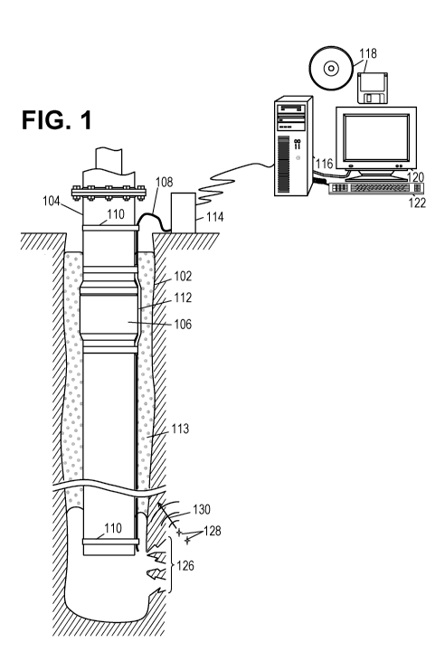
Figure 1 shows an illustrative borehole 102 that has been drilled into the
earth. Such a
borehole may be drilled to ten thousand feet or more in depth and may be
steered horizontally
for more than twice that distance. During the drilling process, the driller
circulates a drilling
fluid to clean cuttings from the bit and carry them out of the borehole 102.
In addition, the
drilling fluid is normally formulated to have a desired density and weight to
approximately
balance the pressure of native fluids in the formation. Thus, the drilling
fluid itself can at
least temporarily stabilize the borehole 102 and prevent blowouts.
To provide a more permanent solution, the driller inserts a casing string 104
into the
borehole. The casing string 104 is normally formed from lengths of tubing
joined by threaded
tubing joints 106. The driller connects the tubing lengths together as the
casing string 104 is
lowered into the borehole 102. During this process, the drilling crew can also
attach a fiber
optic cable 108 and/or an array of sensors to the exterior of the casing with
straps 110 or
other mounting mechanisms. Because the tubing joints 106 have raised profiles,
cable
protectors 112 may be employed to guide the cable 108 over the joints and
protect the cable
from getting pinched between the tubing joints 106 and the borehole 102 wall.
Once the casing string 104 has been placed in the desired position, the
drilling crew
may inject a cement 113 slurry that flows into the annulus around the casing
and sets to seal
the casing to the formation. The cement 113 also provides acoustic coupling
between the
fiber optic cable(s) 108 and the formation. The cable(s) are trimmed and
attached to a
measurement unit 114. The measurement unit 114 supplies laser light pulses to
the cable(s)
and analyzes the returned signal(s) to perform distributed sensing of one or
more
microseismic events and additional attributes of microseismic events. The
additional
attributes of a microseismic event may include an amplitude, location error,
volume, volume
change, energy, frequency, and/or mode of failure associated with the event.
A data processing system 116 may periodically obtain data from the measurement
unit 114 as a function of position and/or time. Software (represented by
information storage
media 118) may run on the data processing system 116 to collect the data and
organize it in a
file or database. The software 118 may respond to user input via a keyboard or
other input
mechanism 122 to display data as an image or movie on a monitor or other
output mechanism
120. The software 118 may process the data to identify individual microseismic
events. Such
information is useful for tracking the progress of hydraulic fracture jobs, in
which this
3
CA 02966151 2017-04-27
WO 2016/085442 PCT/US2014/067015
borehole 102 or another nearby borehole has perforations 126 through which a
fluid is
pumped into the formation to widen and extend existing fractures and create
new fractures.
As such fractures open and move, they cause microseismic events 128 that cause
elastic
waves 130 to propagate through the formation. As such waves propagate, they
encounter the
borehole 102 and the sensors 108 in a manner that enables data collection and
processing.
Figure 2 illustrates seismic waves 130 propagating outwards from a
microscismic
event 128. As the waves 130 travel to the casing string 104 and interact with
the fiber optic
cable 108 or other sensor, they induce changes in the intensity of Rayleigh-
backscatter
reflections that the measurement unit translates into seismic signals 202 that
correspond to
various positions along the casing string. Note that the seismic signals 202
for different
positions exhibit a time shift in accordance with the propagation time from
the event 128 to
the corresponding position in the fiber optic cable 108. The nearer portions
of the fiber optic
cable 108 detect the seismic wave sooner than the farther portions. Array
processing is a
technique that exploits the difference in time shifts that would be expected
for different event
locations. The seismic signals are digitized, stored, and communicated for
processing by
software that extracts the microseismic event information.
One illustrative array processing method is that of calculating similarity
between the
various seismic signals as a function of one or more parameters relating to
location of a
microseismic event. Suitable similarity measures include cross-correlation
(with cross-
covariance as a special case) and semblance. The cross-correlation coefficient
of two signals
can be expressed as:
(m+1)T I (m+1)T (m+1)T
c(r,m) = si(t),s2(t I s(t)1E ,si(t¨r)
(1)
t=mT I t=mT t=mT
where si(t) and s2(t) are the signals across a sequence of time windows of
width T, in is time
window index, and t is a speculative time shift between the two signals. The
value of r that
maximizes the correlation coefficient is often called the time lag between the
two signals, and
it also corresponds to the time shift that minimizes the mean square error
between the
normalized signals. For more than two signals, a pair-wise cross-correlation
may be
determined for every pair of signals and the systematic variation of time lags
may be
analyzed to find the model parameters that provide the best fit. For example,
a plane wave
detected by evenly spaced (and sequentially numbered) sensing stations might
be expected to
yield signals having a systematic time lag variation of nil t, where n is the
difference between
the station numbers.
4
CA 02966151 2017-04-27
WO 2016/085442 PCT/US2014/067015
The semblance coefficient for a set of N signals can be expressed as:
(m+1)T N 2N (m +1)T
e(r, in) = Is - nr) N sn2(t - nr) (2)
t=mT n=1 I n=1 t=mT
where sn(t) are the signals from N sequentially numbered sensing stations n
across a sequence
of time windows of width T, in is time window index, and r is a time shift
between signals
from adjacent stations. The value of r that maximizes the semblance
coefficient (or
alternatively, that maximizes the average cross-correlation coefficient) is
indicative of a plane
wave's incidence direction.
Where v is the propagation velocity of seismic waves through the formation
around a
borehole, d is the inter-station spacing, and 0 is the incidence angle (i.e.,
the angle between
the plane wave's normal and the borehole axis), the expected time lag between
signals from
adjacent stations can be expressed as:
= ¨cos (3)
thereby enabling a straightforward mapping of time lag to incidence angle. The
presence or
absence of a microseismic event can be determined by comparing the semblance
coefficient
or average cross-correlation coefficient to a threshold.
Figure 3 shows a plot of semblance coefficient value (or average cross-
correlation
coefficient value) 302 as a function of incidence angle (vertical axis) and
time window
(horizontal axis). Colors or contour lines can be used to indicate coefficient
values, making
microseismic events readily apparent as peaks 304 in the plot. Such plots can
also reveal
patterns such as a series of events 306 at relatively consistent direction,
perhaps indicating the
propagation of a particular fracture.
As shown in Figure 4, a large array of sensing stations can be subdivided into
sub-
arrays 402A-402N, e.g., groups of eight or sixteen sensing stations. The
foregoing processing
techniques can be used on the signals from each sub-array to determine
corresponding
incidence angles which can then be used to triangulate the location of one or
more
microseismic events 128. Accordingly, Figure 4 shows the fiber-optic cable 108
extending in
an L-shape that provides vertical and horizontal sub-arrays to eliminate any
azimuthal
ambiguity during triangulation. However, other multi-dimensional paths can be
used to
enable triangulation to a unique point. Alternatively, two or more vertical
wells can be used
to provide additional triangulation information. Yet another way to reduce or
eliminate
5
CA 02966151 2017-04-27
WO 2016/085442 PCT/US2014/067015
azimuthal ambiguity would be to employ additional sensors capable of providing
azimuthal
sensitivity, such as accelerometers or geophones.
Figure 5 is a flow diagram of an illustrative microseismic event data
collection
method in preparation for density mapping. Beginning at 502, a fiber optic
cable or other
sensor is deployed along a borehole. As described above, the cable or sensor
array may be
mounted to a casing string, but alternative embodiments include a "pumpable"
sensor cable
that is carried into place by the cement slurry itself. Alternatively, or in
addition, the fiber
optic cable may be embedded in a wireline that is lowered inside the casing,
where borehole
fluid provides acoustic coupling to the casing and formation. In at least one
embodiment,
sensors such as geophones may be deployed in a distributed fashion over the
earth's surface.
At 504, the cable is fixed in place, either by setting of the cement slurry or
anchoring
of the downhole terminus. If desired, the path of the cable can be ascertained
using a
calibration technique such as a surface shot or a wireline run with an
acoustic source.
At 506, microseismic event data, including additional attribute data, is
acquired. For
example, the sensor array may detect or sense microseismic signals, process
the signals to
form microseismic data, and a measurement unit may acquire the data from the
sensor array.
The data may be obtained from the measurement unit by one or more computers
for array
processing at 508, e.g., cross-correlation coefficient calculations, semblance
coefficient
calculations, or the like. At 510, the computers compare the received array-
processing results
to thresholds to detect and triangulate the microseismic events within the
formation. In at
least one embodiment, no additional attribute data is used to detect and
triangulate the
microseismic events. The computers may provide a display of results and/or
detected
microseismic event information, such as the plot of Figure 6, to a user
interface. At 512,
density mapping is performed using the additional attribute data as described
below.
Figure 6 illustrates the location of microseismic events within a formation
using a top
view, front view, and side view. Each circle represents a microseismic event
around a
borehole which is centered in each view. As illustrated, using only location
data (not
additional attribute data), it is unclear whether or not the entire formation
depicted will be
productive and should be included in the stimulated reservoir volume. For
example, one or
more areas within the depicted region may contribute substantially more to
production than
other areas. If these regions can be identified, the stimulated reservoir
volume determination
can be made with increased precision leading to lower-risk decisions that are
based on the
stimulated reservoir volume such as the economic feasibility of extraction.
Microseismic
density mapping allows these regions to be identified.
6
CA 02966151 2017-04-27
WO 2016/085442 PCT/US2014/067015
Figure 7 is a flow diagram of an illustrative method of microseismic density
mapping.
At 702, microseismic data for the stimulated reservoir volume estimate is
obtained including
at least one additional attribute for each of the microseismic events.
Examples of
microseismic events include a hydraulic fracture opening, a secondary fracture
opening off of
the main fracture, a leak off of fluid into natural fractures, a discontinuity
of the formation, a
formation stress indicator, and the like. Location information is determined,
along with
additional attributes such as amplitude, location error, volume, volume
change, energy,
frequency, mode of failure, displacement and crack face normal vector
orientations, and the
like. As used herein, the term "additional attributes" of a microseismic event
does not include
the location of the event. For clarity, one or two additional attributes will
be used as examples
in the following discussion, however, any number of additional attributes may
collected and
processed simultaneously for each of the microseismic events. The microseismic
data may be
obtained at one or more processors in various embodiments.
At 704, the microseismic events are filtered based on one or more additional
attributes. In at least one embodiment, filtering the microseismic events
includes selecting
microseismic events for further processing if values of the one or more
additional attributes
are above or below filtering thresholds. For example, a microseismic event may
be selected
for further processing if a volume change of the event is above a threshold
such as fifty
percent of the average volume change. As another example, a microseismic event
may be
selected for further processing if amplitude of the event is above a
threshold, such as seventy
percent of the total average, and a correlation coefficient of the event is
above a threshold
such as 0.9/1Ø Similarly, multiple filter conditions can be implemented
using Boolean logic
(AND, OR, etc.) to simultaneously filter based on any number of additional
attributes. The
filtering conditions and thresholds may be adjusted as desired.
At 706, a density of the filtered microseismic events is determined.
Determining the
density may include determining whether a threshold number of filtered
microseismic events
lie within a threshold area. If no set of filtered microseismic events meets
the criteria, the
thresholds may be adjusted incrementally until one or more subsets of filtered
microseismic
events meet the criteria. These subsets may be assigned a first weight at 708.
For example,
Figure 8 illustrates the density of microseismic events filtered by volume
change. The darkly-
shaded microseismic events 802 in the center of the three views may be
assigned a first
weight. Depending on the characteristics of the formation, the subsets
assigned a first weight
(or second or greater weight discussed below) can appear in multiple positions
throughout the
formation.
7
CA 02966151 2017-04-27
WO 2016/085442 PCT/US2014/067015
Next, it may be determined that a second number of filtered microseismic
events are
within a second threshold area. The second threshold number and threshold area
may be
larger than the first threshold number and first threshold area because it may
be inclusive of
the first threshold number and first threshold area. The microseismic events
included in these
second subsets that are not included in the first subsets may be assigned a
second weight at
708. For example, the lightly-shaded microseismic events 804 surrounding the
first subsets
802 may be assigned a second weight. Similarly, the medium-dark microseismic
events 806
form third subsets that may be assigned a third weight, etc. In this way, a
density map of the
filtered events within the formation may be created and output for display.
For example, each
microseismic event of a certain weight may be assigned one color for display.
These density
maps allow for insight into the reservoir especially with regard to the
locations of pay zones.
Additionally, the mapping of events according to different additional
attributes, separately or
simultaneously, using overlays and/or color coordination provides for
intuitive visualization
of complex concepts such as the relationships between additional attributes
over time.
At 710, the SRV is estimated using a binning or shrink-wrapping algorithm
described
in Zimmer, "Calculating Stimulated Reservoir Volume (SRV) with Consideration
of
Uncertainties in Microseismic-Event Locations," Canadian Society for
Unconventional Gas,
CSUG/SPE 148610 (2011). SRV is the total volume of rock which has been
fractured and is
presumed to be permeably connected to the borehole, and the SRV may be
estimated by
defining the boundaries of the fracture and measuring the volume encompassed
by the
boundaries. A binning algorithm groups microseismic events into the same "bin"
if the events
are on the same plane perpendicular to the borehole. The outermost events
(furthest from the
borehole within a bin) define the boundaries of the SRV only if a certain
number of events
are located within the bin. A shrink-wrapping algorithm connects the outermost
microseismic
events (without regard to planes perpendicular to the borehole) to their
nearest event
neighbors with straight lines to form an enclosed three dimensional polygonal
area that
defines the boundaries of the SRV. Additional attribute data is not used in
either algorithm,
and both algorithms over-estimate the SRV even when clear location outliers
are eliminated.
The over-estimation occurs because not all of the observed microseismic events
represent
regions hydraulically connected to the borehole and some of these regions have
a high
permeability that would increase production.
At 712, the SRV estimate is corrected based on the density. For example,
correction
factors in the form of adjustable areas around a microseismic event may be
applied to each
event based on the weight given to the event. An event with a high weight may
have a larger
8
CA 02966151 2017-04-27
WO 2016/085442 PCT/US2014/067015
area around it included in the SRV, while an event with a low weight may have
a smaller area
around it included in the SRV. These outermost of these collective areas
define the
boundaries of the SRV, and the volume within the boundaries is measured to
provide the
SRV estimate. When applied to the outermost events, the correction factor may
reduce the
SRV if the outmost events are not associated with a high weight. Conversely,
the correction
factor may increase the SRV if the outermost events are associated with a high
weight.
The areas associated with each weight may be adjusted as desired. Because the
microseismic events are filtered, more microseismic events than clear outliers
may be
eliminated in the SRV estimate. Also, because the areas are adjustable based
on the weight, a
to finely tuned SRV estimate is possible. Finally, because additional
attributes may be
processed separately or simultaneously to create the density map, particularly
high-producing
pay-zones may be identified to mitigate risk associated with decisions based
on the SRV, e.g.
the economic feasibility of extraction. In at least one embodiment, the SRV is
estimated
using the filtered and weighted microseismic events directly, instead of using
the filtered and
weighted events as correction factors. For example, an area surrounding each
filtered and
weighted microseismic event may be determined, and the collective areas may
form the SRV.
Figure 8 is a density map of volume change, i.e. the microseismic events were
filtered
to only show those with a high volume change (above a threshold) and weighted
based on
density. The darkly-shaded microseismic events 802 in the center of the three
views are
assigned a first weight and have a larger area around them included in the
SRV. The lightly-
shaded microseismic events 804 surrounding the first subsets 802 are assigned
a second
weight and have a smaller area around them included in the SRV. Note that
events assigned a
lower weight need not always surround events assigned a higher weight.
Similarly, the
medium-dark microseismic events 806 form third subsets that are assigned a
third weight and
have an even smaller area around them included in the SRV, etc.
Figure 9 is a density map of amplitude and correlation coefficient, i.e. the
microseismic events were filtered to only show those with a high amplitude and
high
correlation coefficient, and weighted based on density. These density maps may
be overlaid
on an SRV estimate based on binning or shrink-wrapping to provide comparison
information,
may be used standing alone, may be used in combination with other maps, or may
be put into
motion to provide further insight.
A method includes fracturing a formation and collecting stimulated reservoir
volume
data including at least one additional attribute of each of a plurality of
microseismic events
within the formation. The method further includes determining a density of the
at least one
9
CA 02966151 2017-04-27
WO 2016/085442 PCT/US2014/067015
additional attribute within the formation. The method further includes
estimating a stimulated
reservoir volume using a binning or shrink-wrapping algorithm. The method
further includes
correcting the stimulated reservoir volume based on the density.
Determining the density may include determining whether a threshold number of
the
first subset of microseismic events is within a threshold area. Assigning each
microseismic
event a weight may include assigning a first subset of microseismic events
based on the
density of the first subset.
A non-transitory information storage medium includes instructions that, when
executed, cause one or more processors to: receive stimulated reservoir volume
data
including at least one additional attribute of each of a plurality of
microseismic events within
a formation. The one or more processors are further caused to determine a
density of the at
least one additional attribute within the formation and output the density for
display.
The one or more processors may be further caused to estimate a stimulated
reservoir
volume using a binning or shrink-wrapping algorithm and correct the stimulated
reservoir
volume based on the density. The at least one additional attribute may be
selected from the
group consisting of amplitude, location error, volume, volume change, energy,
frequency,
and mode of failure. Determining the density may cause the one or more
processors to assign
each microseismic event a weight based on a value of the at least one
additional attribute of
the microseismic event. Assigning each microseismic event a weight may cause
the one or
more processors to assign a first subset of microseismic events a first weight
based on the
value of the at least one additional attribute of the first subset being
between two threshold
additional attribute values. Determining the density may cause the one or more
processors to
determine whether a threshold number of the first subset of microseismic
events is within a
threshold area. Determining the density may cause the one or more processors
to create a
density map of the additional attribute within the formation and wherein
outputting the
density for display causes the one or more processors to output the density
map for display.
A method includes: receiving stimulated reservoir volume data including at
least one
additional attribute of each of a plurality of microseismic events within a
formation. The
method further includes determining a density of the at least one additional
attribute within
the formation and providing the density.
The method may further include estimating a stimulated reservoir volume using
a
binning or shrink-wrapping algorithm and correcting the stimulated reservoir
volume based
on the density. The at least one additional attribute may be selected from the
group consisting
of amplitude, location error, volume, volume change, energy, frequency, and
mode of failure.
CA 02966151 2017-04-27
WO 2016/085442 PCT/US2014/067015
Determining the density may include assigning each microseismic event a weight
based on a
value of the at least one additional attribute of the microseismic event.
Assigning each
microseismic event a weight may include assigning a first subset of
microseismic events a
first weight based on the value of the at least one additional attribute of
the first subset being
between two threshold additional attribute values. Determining the density may
include
determining whether a threshold number of the first subset of microseismic
events is within a
threshold area. Determining the density may include creating a density map of
the additional
attribute within the formation and wherein outputting the density for display
causes the one
or more processors to output the density map for display.
to While the present disclosure has been described with respect to a
limited number of
embodiments, those skilled in the art will appreciate numerous modifications
and variations
therefrom. It is intended that the appended claims cover all such
modifications and variations.
11