Note: Descriptions are shown in the official language in which they were submitted.
CA 02966497 2017-05-01
WO 2016/1(18865 PCT/US2014/072920
MAGNETIC SENSOR ROTATION AND ORIENTATION ABOUT DRILL
BACKGROUND
The present disclosure relates generally to well drilling operations and,
more particularly, to detection and location of proximate well casings during
drilling.
Hydrocarbons, such as oil and gas, are commonly obtained from
subterranean formations that may be located onshore or offshore. The
development
of subterranean operations and the processes involved in removing hydrocarbons
from
a subterranean formation are complex. Typically, subterranean operations
involve a
number of different steps such as, for example, drilling a wellbore at a
desired well
site, treating the wellbore to optimize production of hydrocarbons, and
performing the
necessary steps to produce and process the hydrocarbons from the subterranean
formation.
During drilling operations of hydrocarbon producing wells, it may be
necessary to drill a wellbore with a location and geometry dependent on an
existing
wellbore. For example, in Steam Assisted Gravity Drainage (SAGD) drilling
operations, a production well is typically drilled though a formation
horizontally and a
steam injection well is then drilled to be a given distance above the
production well,
e.g., five meters above the production well. Steam is then injected into the
steam
injection well to raise the temperature of surrounding hydrocarbon-containing
formation. As the hydrocarbon-containing formation is heated, the viscosity of
surrounding hydrocarbon may decrease and/or surrounding hydrocarbons may flow
from the formation into the production well. This SAGD production system has
been
used to produce hydrocarbons too viscous to be produced as a liquid or gas in
its
natural state. For example, hydrocarbon-containing compounds have been
produced
from bituminous sands (or "tar sands") using an SAGD system.
In addition, in some well intervention operations a second wellbore
may be required that intersects and/or connects with a first wellbore. For
example, a
second wellbore may be used to relieve pressure on the first wellbore, direct
fluids
away from the first wellbore, and/or otherwise intervene with the first
wellbore when
access from the surface is unavailable. To accomplish this interfacing of two
1
wellbores within the formation, the first well typically must be located
within the
formation to determine the location of the second well.
For drilling operations where the location of the drilled wellbore
depends on the location of another wellbore, it is desirable for a drilling
operator to
have the ability to determine the distance and/or location of a proximate
wellbore and
make adjustments to the drilling operation as a result.
FIGURES
Some specific exemplary embodiments of the disclosure may be
understood by referring, in part, to the following description and the
accompanying
drawings.
Figure 1 is a diagram showing an illustrative logging while drilling
environment, according to aspects of the present disclosure.
Figure 2 is a diagram showing an example steam well being drilled for
a steam assisted gravity drainage operation, according to aspects of the
present
disclosure.
Figure 3 is a diagram of an example ranging tool proximate to a
production well producing a magnetic field, according to aspects of the
present
disclosure.
Figure 4 is a diagram of an example ranging tool in a misaligned
orientation with respect to a production well, according to aspects of the
present
disclosure.
Figure 5A is a diagram of an example ranging tool proximate to a
production well producing a magnetic field in an aligned orientation,
according to
aspects of the present disclosure.
Figure 5B is a diagram of an example ranging tool proximate to a
production well producing a magnetic field in a misaligned orientation,
according to
aspects of the present disclosure.
Figure 5C is a diagram of an example ranging tool proximate to a
production well producing a magnetic field in a misaligned orientation where
magnetic sensors are oriented in a blind orientation, according to aspects of
the
2
CA 2966497 2020-03-02
CA 02966497 2017-05-01
WO 2016/108865 PCT/US2014/072920
present disclosure.
Figure 6A is a graph illustrating field strength of the measured
magnetic field over a range of orientations, according to aspects of the
present
disclosure.
Figure 6B is a diagram of an example ranging tool showing the range
of magnetic sensor orientations from -90 degrees to 90 degrees represented in
Figure
6A, according to aspects of the present disclosure.
Figure 7 is a diagram of an example ranging tool comprising a
rotatable assembly, according to aspects of the present disclosure.
Figure 8 is a diagram of an example ranging tool comprising a
rotatable assembly, according to aspects of the present disclosure.
Figure 9 is a graph illustrating the absolute percentage error of the
distance measured by an example ranging tool as a function of radial
orientation,
according to aspects of the present disclosure.
While embodiments of this disclosure have been depicted and
described and are defined by reference to exemplary embodiments of the
disclosure,
such references do not imply a limitation on the disclosure, and no such
limitation is
to be inferred. The subject matter disclosed is capable of considerable
modification,
alteration, and equivalents in form and function, as will occur to those
skilled in the
pertinent art and having the benefit of this disclosure. The depicted and
described
embodiments of this disclosure are examples only, and not exhaustive of the
scope of
the disclosure.
DETAILED DESCRIPTION
For purposes of this disclosure, an information handling system may
include any instrumentality or aggregate of instrumentalities operable to
compute,
classify, process, transmit, receive, retrieve, originate, switch, store,
display, manifest,
detect, record, reproduce, handle, or utilize any form of information,
intelligence, or
data for business, scientific, control, or other purposes. For example, an
information
handling system may be a personal computer, a network storage device, or any
other
suitable device and may vary in size, shape, performance, functionality, and
price.
The information handling system may include random access memory (RAM), one or
more processing resources such as a central processing unit (CPU) or hardware
or
3
CA 02966497 2017-05-01
WO 2016/108865 PCT/US2014/072920
software control logic, ROM, and/or other types of nonvolatile memory.
Additional
components of the information handling system may include one or more disk
drives,
one or more network ports for communication with external devices as well as
various
input and output (I/O) devices, such as a keyboard, a mouse, and a video
display. The
.. information handling system may also include one or more buses operable to
transmit
communications between the various hardware components. It may also include
one
or more interface units capable of transmitting one or more signals to a
controller,
actuator, or like device.
For the purposes of this disclosure, computer-readable media may
.. include any instrumentality or aggregation of instrumentalities that may
retain data
and/or instructions for a period of time. Computer-readable media may include,
for
example, without limitation, storage media such as a direct access storage
device
(e.g., a hard disk drive or floppy disk drive), a sequential access storage
device (e.g., a
tape disk drive), compact disk, CD-ROM, DVD, RAM, ROM, electrically erasable
programmable read-only memory (EEPROM), and/or flash memory; as well as
communications media such as wires, optical fibers, microwaves, radio waves,
and
other electromagnetic and/or optical carriers; and/or any combination of the
foregoing.
Illustrative embodiments of the present disclosure are described in
.. detail herein. In the interest of clarity, not all features of an actual
implementation
may be described in this specification. It will of course be appreciated that
in the
development of any such actual embodiment, numerous implementation-specific
decisions are made to achieve the specific implementation goals, which will
vary
from one implementation to another. Moreover, it will be appreciated that such
a
development effort might be complex and time-consuming, but would,
nevertheless,
be a routine undertaking for those of ordinary skill in the art having the
benefit of the
present disclosure.
To facilitate a better understanding of the present disclosure, the
following examples of certain embodiments are given. In no way should the
following examples be read to limit, or define, the scope of the invention.
Embodiments of the present disclosure may be applicable to horizontal,
vertical,
deviated, or otherwise nonlinear wellbores in any type of subterranean
formation.
4
Embodiments may be applicable to injection wells as well as production wells,
including hydrocarbon wells. Embodiments may be implemented using a tool that
is
made suitable for testing, retrieval and sampling along sections of the
formation.
Embodiments may be implemented with tools that, for example, may be conveyed
through a flow passage in tubular string or using a wireline, slickline,
coiled tubing,
downhole robot or the like. "Measurement-while-drilling" ("MWD") is the term
generally used for measuring conditions downhole concerning the movement and
location of the drilling assembly while the drilling continues. "Logging-while-
drilling" ("LWD") is the term generally used for similar techniques that
concentrate
more on formation parameter measurement. Devices and methods in accordance
with
certain embodiments may be used in one or more of wireline (including
wireline,
slicklinc, and coiled tubing), downholc robot, MWD, and LWD operations.
The terms "couple" or "couples" as used herein are intended to mean
either an indirect or a direct connection. Thus, if a first device couples to
a second
device, that connection may be through a direct connection or through an
indirect
mechanical or electrical connection via other devices and connections.
Similarly, the
term "communicatively coupled" as used herein is intended to mean either a
direct or
an indirect communication connection. Such connection may be a wired or
wireless
connection such as, for example, Ethernet or LAN. Such wired and wireless
connections are well known to those of ordinary skill in the art and will
therefore not
be discussed in detail herein. Thus, if a first device communicatively couples
to a
second device, that connection may be through a direct connection, or through
an
indirect communication connection via other devices and connections.
FIG. 1 is a diagram of a subterranean drilling system 100, according
to aspects of the present disclosure. The drilling system 100 comprises a
drilling
platform 2 positioned at the surface 102. In the embodiment shown, the surface
102
comprises the top of a formation 104 containing one or more rock strata or
layers 18a-
c, and the drilling platform 2 may be in contact with the surface 102. In
other
embodiments, such as in an off-shore drilling operation, the surface 102 may
be
separated from the drilling platform 2 by a volume of water.
The drilling system 100 comprises a derrick 4 supported by the drilling
platform 2 and having a traveling block 6 for raising and lowering a drill
string 8. A
5
CA 2966497 2020-03-02
CA 02966497 2017-05-01
WO 2016/108865 PCT/US2014/072920
kelly 10 may support the drill string 8 as it is lowered through a rotary
table 12. A
drill bit 14 may be coupled to the drill string 8 and driven by a downhole
motor and/or
rotation of the drill string 8 by the rotary table 12. As bit 14 rotates, it
creates a
borehole 16 that passes through one or more rock strata or layers 18. A pump
20 may
circulate drilling fluid through a feed pipe 22 to kelly 10, downhole through
the
interior of drill string 8, through orifices in drill bit 14, back to the
surface via the
annulus around drill string 8, and into a retention pit 24. The drilling fluid
transports
cuttings from the borehole 16 into the pit 24 and aids in maintaining
integrity or the
borehole 16.
The drilling system 100 may comprise a bottom hole assembly (BHA)
coupled to the drill string 8 near the drill bit 14. The BHA may comprise
various
downhole measurement tools and sensors and LWD and MWD elements, including a
ranging tool 26. The ranging tool 26 may comprise at least one transmitter and
receiver capable of communicating with adjacent and/or proximate tool
electronics
located on the drill string 8. As the bit extends the borehole 16 through the
formations
18, the ranging tool 26 may collect measurements relating to magnetic field
strength,
e.g., the strength of a magnetic field generated by a metallic structure
located within
the formation 104. In certain embodiments, the orientation and position of the
tool 26
may be tracked using, for example, an azimuthal orientation indicator, which
may
include magnetometers, inclinometers, and/or accelerometers, though other
sensor
types such as gyroscopes may be used in some embodiments. In embodiments
including an azimuthal orientation indicator, the ranging measurements may be
associated with a particular azimuthal orientation through azimuthal binning,
as will
be described below.
In certain embodiments, the ranging tool 26 may also include a control
unit (not shown) coupled to the transmitters and receivers that controls their
operation, stores measurements, and in certain instances processes the
magnetic field
measurements to determine a distance from a magnetic field generating object,
and in
conjunction with azimuthal orientation indicator/sensor data, may determine
the
direction of a magnetic field generating object. Example control units may
include
microcontrollers and microcomputers and any other device that contains at
least one
processor communicably coupled to memory devices containing a set of
instructions
6
CA 02966497 2017-05-01
WO 2016/108865 PCT/US2014/072920
that when executed by the processor, cause it to perform certain actions. In
certain
embodiments, a control unit of the ranging tool 26 may be communicably coupled
to
other controllers within the BHA.
The BHA may also include a steering tool 34 that controls the direction of
the drill bit 14 and, therefore, the direction in which the borehole 16 will
be drilled.
Example steering tools include point-the-bit and push-the-bit type systems.
One use of
the steering tool 34 is to direct the drill bit 14 and borehole 16 to one of
the formation
strata 18a-c that contains hydrocarbons. Other uses include avoiding certain
undesired
strata or formation bodies, following existing borehole, maintaining a
distance from an
adjacent wellbore, or intersecting existing borehole to drill relief wells in
the case of a
blowout. In certain embodiments, the steering tool 34 may include a separate
control unit
(not shown) that controls the operation of the steering tool 34. The control
unit may be
communicably coupled to other controllers within the BHA, such as a control
unit within
the resistivity logging tool 26, and may alter its operation depending on
measurements or
signals received from the other controllers.
The tools and sensors of the BHA including the ranging tool 26 may be
communicably coupled to a telemetry element 28. The telemetry element 28 may
transfer measurements from the ranging tool 26 to a surface receiver 30 and/or
to
receive commands from the surface receiver 30. The telemetry element 28 may
comprise a mud pulse telemetry system, and acoustic telemetry system, a wired
communications system, a wireless communications system, or any other type of
communications system that would be appreciated by one of ordinary skill in
the art
in view of this disclosure. In certain embodiments, some or all of the
measurements
taken at the ranging tool 26 may also be stored within the tool 26 or the
telemetry
element 28 for later retrieval at the surface 102.
In certain embodiments, the drilling system 100 may comprise an
information handling system 32 positioned at the surface 102. The information
handling system 32 may be communicably coupled to the surface receiver 30 and
may
receive measurements from the ranging tool 26 and/or transmit commands to the
ranging tool 26 though the surface receiver 30. The information handling
system 32
may also receive measurements from the ranging tool 26 when the tool 26 is
retrieved
at the surface 102. As will be described below, the information handling
system 32
7
may process the magnetic field measurements and/or azimuthal orientation to
determine a distance from and/or direction of the magnetic field generating
object.
At various times during the drilling process, the drill string 8 may be
removed from the borehole 16. Once the drill string 8 has been removed,
measurement/logging operations can be conducted using a wireline tool 34,
i.e., an
instrument that is suspended into the borehole 16 by a cable 15 having
conductors for transporting power to the tool and telemetry from the tool body
to the
surface 102. The wireline tool 34 may include a ranging tool 36 having at
least one
magnetic sensor pair structured and arranged to measure the magnetic field
and/or the
magnetic field gradient generated by a metallic object, similar those
described above
in relation to the ranging tool 26. The ranging tool 36 may be communicatively
coupled to the cable 15. A logging facility 44 (such as a truck, although it
may
be any other structure) may collect measurements from the ranging tool 36, and
may include computing facilities (including, e.g., a control unit) for
controlling,
processing, storing, and/or visualizing the measurements gathered by the
ranging tool
36. The computing facilities may be communicatively coupled to the ranging
tool
36 by way of the cable 15. In certain embodiments, the surface control unit 32
may
serve as the computing facilities of the logging facility 44.
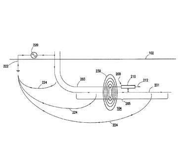
Fig. 2 shows a schematic of a production well 201 and a drill string
200 in the process of drilling a proximate well 203, e.g., a steam injection
well. In
certain embodiments, hydrocarbons may flow into the production well 201 to be
captured and/or produced from the formation 104. In certain embodiments, the
proximate well 203 may be an injection well used to stimulate the flow of
hydrocarbons into the production well 201. The drill string 200 may comprise a
ranging tool 210 and a drill bit 212. In certain embodiments, the production
well 201
and the proximate well 203 may comprise a steam assisted gravity drainage
(SAGD)
system. The production well 201 may comprise a production section 205
extending
through the formation 104 in a lateral direction, substantially parallel with
the surface
102. In certain embodiments, it may be desirable to drill the proximate well
203
substantially parallel with and directly above the production section 205 of
the
production well 201 so that the distance between the proximate well 203 and
the
production section 205 is substantially constant. For
example, in certain
8
CA 2966497 2020-03-02
CA 02966497 2017-05-01
WO 2016/108865 PCT/US2014/072920
embodiments, the proximate well 203 and the production section 205 may be 3
meters
to 10 meters apart. For example, the proximate well 203 may be 5 meters ( 1
meter)
from the production section 205. As such, the location of the proximate well
203 may
depend on the position of the production well 201 within the formation.
In certain embodiments, the production well 201 may comprise a
casing. The casing may be excited with an electric current. In certain
embodiments, a
power amplifier 220 may be used to generate the electric current. In certain
embodiments, the electric current may have a low frequency, for example, less
than
100 Hz. For example, the electric current may have a frequency of less than
10Hz.
The electric current may flow down the casing in the production well 201 and
through
the formation 104 to at least one ground rod 222. The ground rod 222 may be
placed
such that the electric current bleed-off 224 is guided away from the drilling
system
200 and/or proximate well 203 so that the electric current bleed-off 224
minimally
interferes with the ranging tool 210 on the drilling system 200. For example,
as
shown in Fig. 2, the ground rod 222 may be placed opposite the direction that
the
production section 205 extends. In certain embodiments, the ground rod 222 may
be
placed 0.5 km to 4 km away from the production well 201. For example, the
ground
rod may be placed 1 km away from the production well 201.
In certain embodiments, the casing may be excited to delineate the
production well's location. However, consistent with the present disclosure,
other
conductive materials may be used to guide electric current through the length
of the
production well 201.
The electric current flowing through the casing or conductive material
may create a magnetic field 230 thereabout. The ranging tool 210 may measure a
gradient magnetic field strength in a radial direction to determine the
distance from
the production well, as will be discussed further herein. In certain
embodiments, the
ranging tool 210 may also use the component (R, T, and Z) field strength
measurements in conjunction with the azimuthal orientation data to determine
the
direction of the production well.
Referring to Fig. 3, a cross-section of a casing 305 within a production
well is shown creating a magnetic field 310. The magnetic field 310 may extend
radially from the casing 305 and weaken as a function of distance from the
casing
9
CA 02966497 2017-05-01
WO 2016/108865 PCT/US2014/072920
305. The ranging tool 210 may be located within the magnetic field 310.
In certain embodiments, the ranging tool 210 may comprise a first
magnetic sensor 320 and a second magnetic sensor 322, positioned on the
ranging tool
210 substantially opposite one another (i.e. substantially 1 g0 degrees from
one
another). The magnetic sensors substantially opposite one another are referred
to
herein as a "magnetic sensor pair." The magnetic sensors 320, 322 may sense at
least
two perpendicular directional components of the magnetic field 310 (a radial
(R)
component and a tangential (1) component). In certain embodiments, the
magnetic
sensors 320, 322 may also sense a Z component of the magnetic field 310. In
certain
embodiments, the magnetic sensors 320, 322 may be oriented such that the Z
component extends in a lengthwise direction of the drill collar (orthogonal to
the view
shown in Fig. 3), where the respective Z components point in the same
direction. In
certain embodiments, the respective R components of the magnetic sensor pair
may
point away from the center of the drill collar, in substantially opposite
directions, and
the T components may be tangential to the ranging tool 210.
When located within the magnetic field 310 generated by the
production well 305, the first magnetic sensor 320 may measure a first
magnetic field
strength and the second magnetic sensor 322 may measure a second magnetic
field
strength. A magnetic field gradient may be determined from the magnetic field
strength measured by the first and second magnetic sensors 320, 322, as shown
by
Equation 1:
-H
gradient(H) ¨ 2I (1)
where gradient(H) is the measured gradient of the magnetic field, H1 and H2 is
the
magnetic field strength measured by the respective magnetic sensors 320, 322,
and d
is the distance between the sensors measured in the radial direction.
The magnetic sensors 320, 322 are oriented in FIG. 3 to be aligned in
the radial direction with respect to the production well. As used herein, the
term
"aligned" will be used to mean radial alignment with the production well as
shown in
FIG. 3. In this orientation, the magnetic field gradient is measured entirely
in
tangential components (T) of the magnetic sensors 320, 322. As such, in this
orientation, only the T components are needed to calculate the ranging
distance, In
CA 02966497 2017-05-01
WO 2016/108865 PCIATS2014/072920
addition, the maximum Signal-to-Noise Ratio (SNR) may be achieved in this
orientation since the magnetic sensors are at a maximum radial distance d from
one
another and the radial components (R) are close to or equal to zero, which
simplifies
the calculations needed to determine the ranging distance. When the magnetic
sensors are in alignment with the producer, the tools/sensors azimuthal
orientation
may be sufficient to determine direction of the producer without needing to
determine
an angle between the sensors and producer using field strength components. In
certain
embodiments, using tool orientation to determine direction may reduce error
involved
directional measurements using magnetic field sensors.
The ranging measurement calculation is represented by Equation 2
when the magnetic sensors are substantially misaligned, as shown in Fig. 4. If
the two
sensors 320, 322 have an angle a with respect to the X-axis (with the
production well
305 on the X-axis), then the distance D from the production well 305 is
represented
by Equation 2:
B
D(r,a,B1,132) =r = I B22+812 cos(a) I + 11 (2)
is1i-IB21 122+312 cos(cr) )2 11-1/321
(2)
where B1 is the absolute value of the total magnetic field measured by the
first
magnetic sensor 320, B2 is the absolute value of the total magnetic field
measured by
the second magnetic sensor 322, and r is the radius of the ranging tool. When
a = 0
(when the magnetic sensors are aligned), Equation 2 may be simplified as:
D(r,B1,B2) = r = 1:111221
(3)
In addition, eddy currents generated on the metallic body/chassis of the tool
due to the
magnetic field of the producer well may be a source of error in the ranging
measurement. Considering the effect of eddy currents at a = 0, Equation 3 can
be
written as:
D(B1,B2,r,b1,b2) = r = 101+b1)+(82+b2)1
(4)
1.031+b1)¨(82+b2).1
where bl is the absolute value of the tangential magnetic field generated by
eddy
currents at the first magnetic sensor 320, and b2 is the absolute value of the
tangential
magnetic field generated by eddy currents at the second magnetic sensor 322.
Since r
is very small compared with distance D, the difference between bl and b2 may
be
11
CA 02966497 2017-05-01
WO 2016/108865 PCT/US2014/072920
approximated to be about 0. Similarly, the values of bl and b2 are very small
as
compared with B1 and B2. As such, even with the effect of eddy currents at a =
0, the
ranging distance error according to Equation 4 may remain very small and
readily
quantifiable due to the alignment of the magnetic sensors.
In certain embodiments, the ranging tool is stationary while the
gradient measurement is made. To be stationary, the drilling operator must
stop
drilling and/or stop rotating the tool string for each ranging measurement. In
certain
embodiments, the drilling operator may not have control of how the drill
string is
oriented when it comes to a complete stop. As a result, a ranging tool mounted
on the
drill string may have an uncontrolled alignment with the production well and
is
unlikely to be substantially aligned. As discussed above, more complex
calculations
that inherently have lower SNR and resolution may be required with such an
uncontrolled orientation.
FIGS. 5A-5C show a range of ranging tool orientations with respect to
the production well. FIG. 5A shows an ideal alignment with a gradient distance
510
is at a maximum. FIG. 5B shows a skewed alignment with a gradient distance 512
smaller than the gradient distance in ideal alignment. In addition, as shown
in FIG.
5C, the ranging tool may stop in a "blind" orientation with respect to the
production
well 505, where the both magnetic sensors 520, 522 are an equal radial
distance from
the producer and therefore see an equal magnetic field strength, where a
magnetic
field gradient measurement may be close to zero. In this case, the ranging
tool may
comprise a second magnetic sensor pair 524, 526 placed orthogonal to the first
magnetic sensor pair 520, 522. In certain embodiments, the ranging tool may
select
the magnetic sensor pair that has the greatest gradient measurement, and is
therefore
closest to ideally aligned. In certain embodiments, the ranging tool may use
the
magnetic sensor pair with the greatest gradient measurement to obtain a
primary
distance measurement and the other magnetic sensor pair to obtain a secondary
distance measurement. The secondary distance measurement may be used as a
redundant verification on the primary distance measurement.
In certain embodiments, the drill operator may slowly rotate the tool
string in an attempt to bring the magnetic sensor pair into alignment with the
production well. A continuous telemetry uplink between the ranging tool and
the
12
CA 02966497 2017-05-01
WO 2016/108865 PCT/US2014/072920
surface may allow the ranging tool to communicate when the T components are at
a
maximum and/or the R components are at a minimum, which may indicate that the
magnetic sensor pair is in alignment. The ranging tool may comprise a
transmitter.
In certain embodiments, the transmitter may be an electromagnetic transmitter
or a
mud pulse telemetry transmitter. For example, an electromagnetic transmitter
may be
used to wirelessly transmit data while the ranging tool is not measuring the
magnetic
field or the magnetic field gradient, and/or the electromagnetic transmitter
may
transmit at a frequency that does not interfere with the magnetic field
measured by the
magnetic sensor pair.
FIG. 6A shows a graph of the normalized magnetic field strength for
the R and T components vs. the magnetic sensor pair orientation with the
production
well, corresponding to the range of magnetic sensor pair orientations shown in
FIG.
6B. FIG. 6B shows an example ranging tool 610 comprising a magnetic sensor
pair
comprising a first magnetic sensor 620a and a second magnetic sensor 620b in -
90, 0,
and +90 degree orientations. Show first at the -90 degree orientation, the
magnetic
sensors 620a and 620b may be equidistant from an excited metallic structure
605,
where the first magnetic sensor 620a may be on the right of the ranging tool
610 and
the second magnetic sensor 620b may be on the left of the ranging tool 610.
This
orientation may be referred to as a blind orientation, as discussed above,
since the
magnetic field gradient measured by the magnetic sensor pair may provide
little to no
distance information for the metallic structure 605. Once the ranging tool
rotates
clockwise 90 degrees, the first magnetic sensor 620a may be in a near aligned
position
630a closest to the metallic structure and the second magnetic sensor 630b may
be in
a far aligned position 630b away from the metallic structure. This position
may be
referred to as the aligned position, or ideal position, and is represented as
a 0 degrees
orientation on FIG. 6A. (Although the ranging tool is shown rotating clockwise
in
this example, the ranging tool may rotate in a clockwise or a counterclockwise
direction.) Rotating the ranging tool a further 90 degrees in the clockwise
direction
brings the magnetic sensor pair into a +90 degrees orientation, where the
first
magnetic sensor 620a is in the position initially occupied by the second
magnetic
sensor 620b, and vice versa.
Referring back to FIG. 6A, the T component may be at a maximum
13
CA 02966497 2017-05-01
WO 2016/108865 PCT/US2014/072920
when the magnetic sensor pair is aligned with the production well, shown at 0
degrees. At this point of ideal alignment, the R component may have a sharp
minimum at 0 field strength while the field strength measured by the T
component
may have a rounded maximum peak. In certain embodiments, the operator may
rotate
the drill string and/or ranging tool until the R component measures a minimum
field
strength in order to align the ranging tool. In certain embodiments, the
operator may
rotate the drill string and/or ranging tool until the T component measures a
maximum
field strength in order to align the ranging tool. Manually aligning the
ranging tool for
each measurement may be time consuming and difficult since the drill string
may be
hard to precisely control.
As shown in FIG. 7, in certain embodiments, the ranging tool 701 may
comprise a rotatable assembly 710 rotatable around a ranging tool body 702.
The
magnetic sensor pair may be mounted on the rotatable assembly 710 (the first
magnetic sensor 720 is visible in FIG. 7). In certain embodiments, an
azimuthal
orientation sensor (not shown) may be mounted to the rotatable assembly. The
rotatable assembly 710 may comprise a motor to actuate rotation of the
magnetic
sensor pair around the ranging tool 701. In certain embodiments, the motor may
be
an electric motor. The motor may rotate the rotatable assembly slowly or in
steps to
minimize generation of frequencies that could interfere with the magnetic
field. In
addition, the motor may be placed away from the magnetic sensor to minimized
interference with the magnetic field. In certain embodiments, the ranging tool
701
may comprise an electronics package 730 connected to the magnetic sensors
and/or
the azimuthal orientation sensor. The electronics package may comprise a
battery and
provide power to the magnetic sensors and/or the azimuthal orientation sensor.
In
certain embodiments, the ranging tool 701 may comprise carbon bushes, slip
rings,
and/or any other form of rotating electrical connection structured and
arranged to
provide power to the magnetic sensors and/or the azimuthal orientation sensor.
In
certain embodiments, the electronics package 730 may comprise a wireless
interface
that may transmit sensor data to adjacent tool electronics. The wireless
transmitter
may receive a digital signal from adjacent tool electronics, where the digital
signal
may comprise control commands from the surface.
In certain embodiments, the ranging tool 701 may comprise an
14
CA 02966497 2017-05-01
WO 2016/108865 PCT/US2014/072920
inductive transformer coupling 711 between a first coil 712 attached to the
ranging
tool body 702 and a second coil 714. The inductive transformer coupling 711
may be
connected to the electronics package, the magnetic sensor pair, and/or the
azimuthal
orientation sensor. The inductive transformer coupling 711 may be structured
and
arranged to generate power wirelessly while the first coil 712 and the second
coil 714
rotate with respect to one another, using a Contactless Energy Transmission
(CET)
method. For example, the first coil 712 may be attached to the ranging tool
body 702
and the second coil 714 may be attached to the rotatable assembly 710. The
inductive
transformer coupling 711 may be operable to generate AC power, and a power
converter may convert the AC power to DC power. In certain embodiments, a soft
ferrous material (not shown) may increase the coupling efficiency of the
inductive
coupling and/or insulate the magnetic fields radiated from the inductive
transformer
coupling 711.
In certain embodiments, the electronics package 730 may comprise a
controller connected to the magnetic sensor pair and the motor. To take a
distance
measurement, the controller may receive magnetic field measurements from the
sensor pair and determine if the R component of the magnetic sensor pair is at
a null
minimum, as discussed with reference to FIG. 6 above. The controller may
signal the
motor to rotate the rotatable assembly, causing the magnetic sensor pair to
rotate, until
the R component is at a minimum and/or the T component is at a maximum. For
example, the controller may rotate the rotatable assembly so that the R
component is
within 10% of a minimum value and/or so that the T component is within 5% of a
minimum value. For example, in certain embodiments, the controller may rotate
the
rotatable assembly so that the magnetic sensor pair is within 15 degrees of
ideal
alignment with the production well; for example, where the magnetic sensor is
within
5 degrees of ideal alignment. In certain embodiments, the controller may align
the
ranging tool with the production well automatically, without assistance from
the
operator.
Once the controller determines that the R components are at a
minimum, and therefore that the magnetic sensors are aligned, the controller
may read
the magnetic field measured by the magnetic sensor pair and/or azimuthal
orientation
measured by the azimuthal sensor. In certain embodiments, the controller may
CA 02966497 2017-05-01
WO 2016/108865 PCT/US2014/072920
compute the distance and direction reading at the tool and send a computed
distance
to the surface. In certain embodiments, the controller may send the magnetic
field
measurement to the surface where a processor may compute the production well
distance and direction. Once the production well distance and direction is
received at
the surface, it may be displayed to the operator at a computer. The operator
may use
the production well distance and direction to adjust direction of the drill or
maintain
course if the ranging tool is at a desired distance from and above the
production well.
Referring now to FIG. 8, an example ranging tool 800 is shown
comprising a rotatable assembly 810 comprising a magnetic sensor pair 820
andJor an
azimuthal orientation sensor (not shown). The rotatable assembly 810 may
mounted
on a drill string 805 and be structured and arranged to rotate around the
drill string
805. For example, given a clockwise drill string rotation (shown by arrow
814), the
rotatable assembly may rotate in the opposite, counterclockwise direction
(shown by
arrow 816). In certain embodiments, the rotatable assembly may have a
substantially
equal and opposite rotation to the drill string rotation to keep sensor pair
stationary
and/or in the aligned orientation, e.g., keeping the ranging tool within 15
degrees of
alignment with a production well. In certain embodiments, the rotatable
assembly
810 may comprise at least one rotation sensor (not shown) mounted on the
rotatable
assembly 810. For example, in certain embodiments, the at least one rotation
sensor
may be a magnetometer. The at least one rotation sensor may detect rotation
from the
drill string 805 and send a control signal to the rotatable assembly 810 in
response.
For example, the at least one rotation sensor may send a control signal
instructing the
rotatable assembly 810 to rotate in the opposite direction of detected
rotation from the
drill string 805.
In certain embodiments, the rotatable assembly 810 may comprise at
least one accelerometer (not shown) mounted on the rotatable assembly 810. The
at
least one accelerometer may be structured and arranged to detect vibration of
the drill
string 805 and/or the rotatable assembly 810. In response to a detected
vibration, the
at least one accelerometer may send a control signal instructing the rotatable
assembly
810 to vibrate inverse to the drill string 805. As such, the at least one
rotation sensor
and/or the at least one accelerometer may keep the magnetic sensor pair 820 in
a set
radial and/or axial alignment respectively.
16
CA 02966497 2017-05-01
WO 2016/108865 PCT/US2014/072920
In certain embodiments, the rotatable assembly 810 may be mounted
on a vibration damper (not shown). The vibration damper may dampen vibrations
from the drill string on the magnetic sensors, reducing noise imputed to the
magnetic
sensors while drilling. In certain embodiments, the rotatable assembly may be
mounted on an active vibration management (AVM) system. The AVM system may
comprise a motor and a processor connected to the motor. The processor may
receive
movement information from an accelerometer located on the drill string and
actuate
the motor to vibrate the AVM system, and the rotatable assembly, in reverse of
the
drill string vibration to keep the rotatable assembly in place. In certain
embodiments,
the motor may be structured and arranged to vibrate the ranging tool opposite
to the
drill string vibration detected by the at least one accelerometer. For
example, the at
least one accelerometer may signal the motor to vibrate counter and/or inverse
the
drill string vibration. In this way, the motor may stabilize the ranging tool
in response
to drill string vibration.
In certain embodiments, the controller may be connected to, and be
configured to receive drill string movement signals from, the at least one
magnetometer and/or the at least one accelerometer; the controller may also be
connected to, and be configured to receive alignment signals from, the
magnetic
sensor pair. As such, in certain embodiments, the controller may be configured
to
receive the R component and/or T component data to align the magnetic sensor
pair
with the production well and rotation and/or vibration data to maintain
alignment.
In certain embodiments, the motor may rotate the rotatable assembly
during drilling while the drill string rotates. In certain embodiments, the
motor may
rotate the rotatable assembly counter to the drill string rotation at the same
speed or
RPM as the drill string to keep the magnetic sensor assembly substantially
aligned
with the production well. As such, the ranging tool may be used to measure the
magnetic field gradient to provide ranging information while drilling.
Referring now to FIG. 9, a graph of absolute value of relative percent
error of a distance measured by an example ranging tool is shown as a function
of
radial orientation (degrees) of the magnetic sensor pair. The magnetic sensor
pair
orientation ranges from -90 degrees to 90 degrees, as shown with reference to
FIGS.
6A & 6B. At an orientation angle of 0 degrees, the magnetic sensor pair may be
said
17
CA 02966497 2017-05-01
WO 2016/108865 PCT/US2014/072920
to be axially aligned with the production well. At 0 degrees the magnetic
sensor pair
may measure the magnetic field and/or magnetic field gradient and obtain a
distance
measurement with minimal error. As the magnetic sensor pair moves away from an
orientation of 0 degrees toward an orientation of 90 degrees or -90 degrees,
the
.. relative error of the distance measurement increases ¨ up to about 70% as
shown by
example. In certain embodiments, measuring the magnetic field while the
magnetic
sensor pair is in substantial alignment with the production well may reduce
error of
the calculated distance away from the production well.
In certain embodiments, a method for locating a metallic structure
within a formation may comprise drilling a wellbore in a formation using a
drill
attached to drill string, the drill string comprising a ranging tool
comprising a
magnetic sensor pair; exciting a metallic structure with an electric current;
aligning
the magnetic sensor pair with the metallic structure; measuring at least one
of a
magnetic field and a magnetic field gradient generated from the metallic
structure
with the magnetic sensor pair; determining a distance of the metallic
structure from
the ranging tool; adjusting the drilling parameters in response to the
distance of the
metallic structure from the ranging tool.
In certain embodiments, a method for drilling a wellbore within a
formation may comprise drilling a wellbore in a formation using a drill
attached to
.. drill string, the drill string comprising a ranging tool; exciting a
metallic structure with
an electric current; aligning the magnetic sensor pair with the metallic
structure;
measuring with the ranging tool at least one of a magnetic field and a
magnetic field
gradient generated from the metallic structure while rotating the drill
string;
determining a distance of the metallic structure from the ranging tool;
measuring
.. azimuthal orientation of the ranging tool/magnetic sensor pair with the
azimuthal
sensor; determining the direction of the metallic structure from the ranging
tool;
adjusting the drilling parameters in response to the distance and direction of
the
metallic structure from the ranging tool.
The present disclosure allows detection of a metallic structure within a
formation through which a wellbore is being drilled. The distance and location
information may allow a drilling operator to drill the wellbore within
substantially
consistent range of the metallic structure or may allow the drilling operator
to drill
18
CA 02966497 2017-05-01
WO 2016/108865 PCT/US2014/072920
into the metallic structure. As such, the ranging information provided by the
present
disclosure may be used to more accurately and efficiently drill a wellbore
that is
location sensitive. The present disclosure has discussed the metallic
structure as
being a production well for illustrative purposes, however, the metallic
structure may
be any structure excitable by an electric current and that generates a
magnetic field in
response to being excited by such an electric current.
Therefore, the present disclosure is well adapted to attain the ends and
advantages mentioned as well as those that are inherent therein. The
particular
embodiments disclosed above are illustrative only, as the present disclosure
may be
modified and practiced in different but equivalent manners apparent to those
skilled in
the art having the benefit of the teachings herein. Furthermore, no
limitations are
intended to the details of construction or design herein shown, other than as
described
in the claims below. It is therefore evident that the particular illustrative
embodiments
disclosed above may be altered or modified and all such variations are
considered
.. within the scope and spirit of the present disclosure. Also, the terms in
the claims
have their plain, ordinary meaning unless otherwise explicitly and clearly
defined by
the patentee. The indefinite articles "a" or "an," as used in the claims, are
defined
herein to mean one or more than one of the element that it introduces.
19