Note: Descriptions are shown in the official language in which they were submitted.
CA 02967919 2017-05-15
WO 2016/099504
PCT/US2014/071101
SHOULDER EFFECT REDUCTION
Background
The gathering of downhole information has been performed by the oil industry
for many
years. Modern petroleum drilling and production operations demand a great
quantity of
information relating to the parameters and conditions downhole. Such
information typically
includes the location and orientation of the borehole and drilling assembly,
earth formation
properties, and drilling environment parameters downhole. The gathering of
information relating
to formation properties and conditions downhole is commonly referred to as
"logging", and can
be performed during the drilling process itself.
Various measurement tools exist for use in logging while drilling. One such
tool is the
electromagnetic resistivity tool, which includes one or more antennas for
transmitting an
electromagnetic signal into the formation and one or more antennas for
receiving a formation
response. When operated at low frequencies, the electromagnetic resistivity
tool (resistivity tool)
may be called an "induction" tool, and at high frequencies it may be called an
electromagnetic
wave propagation tool. Though the physical phenomena that dominate the
measurement may
vary with frequency, the operating principles for the tool are consistent. In
some cases, the
amplitude and/or the phase of the received signals are compared to the
amplitude and/or phase
of the transmitted signals to measure the formation resistivity. In other
cases, the amplitude
and/or phase of the different received signals are compared to each other to
measure the
formation resistivity.
When plotted as a function of time or position, the resistivity tool
measurements are
termed "logs" or "resistivity logs". Such logs may provide indications of
hydrocarbon
concentrations and other information useful to drillers and completion
engineers. In particular,
logs may provide information useful for steering the drilling assembly.
Electromagnetic
resistivity tools have been widely used to explore the subsurface based on the
electrical
resistivity (or its inverse, conductivity) of the rock formation. The
formation with a higher
resistivity indicates a higher possibility of hydrocarbon accumulations.
Artifacts can occur in resistivity logs. Specifically, the resistivity of one
layer of an earth
formation may interfere with the logging of resistivities of surrounding
layers, especially at layer
boundaries of anisotropic formations, leading to errors. The change in
resistivity between the
layers can cause charge accumulation on the boundary between layers, further
distorting
measurements at the boundary location. This is sometimes called the "shoulder"
or "shoulder-
bed" effect. Such artifacts decrease logging accuracy, which decreases
efficiency.
1
CA 02967919 2017-05-15
WO 2016/099504
PCT/US2014/071101
Brief Description of the Drawings
For a detailed description of the various disclosed embodiments, reference
will now be
made to the accompanying drawings in which:
Figure 1 is an illustration of a logging while drilling environment
implementing shoulder
effect reduction;
Figure 2 is an illustration of a resistivity logging tool compatible with
shoulder effect
reduction;
Figure 3 is a plot for describing antenna orientation of the logging tool;
Figure 4 is a flow chart showing a shoulder effect reduction method;
Figure 5 is a diagram showing a system for shoulder effect reduction;
Figure 6 is a plot showing the shoulder effect; and
Figure 7 is an illustration of a wireline logging environment implementing
shoulder
effect reduction.
It should be understood, however, that the specific embodiments given in the
drawings
and detailed description thereto do not limit the disclosure. On the contrary,
they provide the
foundation for one of ordinary skill to discern the alternative forms,
equivalents, and
modifications that are encompassed together with one or more of the given
embodiments in the
scope of the appended claims.
Notation and Nomenclature
Certain terms are used throughout the following description and claims to
refer to
particular system components and configurations. As one skilled in the art
will appreciate,
companies may refer to a component by different names. This document does not
intend to
distinguish between components that differ in name but not function. In the
following discussion
and in the claims, the terms "including" and "comprising" are used in an open-
ended fashion,
and thus should be interpreted to mean "including, but not limited to...".
Also, the term
"couple" or "couples" is intended to mean either an indirect or a direct
electrical connection.
Thus, if a first device couples to a second device, that connection may be
through a direct
electrical connection, or through an indirect electrical connection via other
devices and
connections. In addition, the term "attached" is intended to mean either an
indirect or a direct
physical connection. Thus, if a first device attaches to a second device, that
connection may be
through a direct physical connection, or through an indirect physical
connection via other
devices and connections.
2
CA 02967919 2017-05-15
WO 2016/099504
PCT/US2014/071101
Detailed Description
The issues identified in the background are at least partly addressed by
systems and
methods for reducing the shoulder effect both in a wireline environment and in
a logging while
drilling (LWD) environment. To illustrate a context for the disclosed systems
and methods,
Figure 1 shows a well during drilling operations. A drilling platform 2 is
equipped with a derrick
4 that supports a hoist 6. Drilling of oil and gas wells is carried out by a
string of drill pipes
connected together by "tool" joints 7 so as to form a drill string 8. The
hoist 6 suspends a kelly
that lowers the drill string 8 through rotary table 12. Connected to the lower
end of the drill
10 string 8 is a drill bit 14. The bit 14 is rotated and drilling
accomplished by rotating the drill
string 8, by use of a downhole motor near the drill bit, or by both methods.
Drilling fluid, termed mud, is pumped by mud recirculation equipment 16
through
supply pipe 18, through drilling kelly 10, and down through the drill string 8
at high pressures
and volumes to emerge through nozzles or jets in the drill bit 14. The mud
then travels back up
the hole via the annulus formed between the exterior of the drill string 8 and
the borehole wall
20, through a blowout preventer, and into a mud pit 24 on the surface. On the
surface, the
drilling mud is cleaned and then recirculated by recirculation equipment 16.
For a LWD environment, downhole sensors 26 are located in the drillstring 8
near the
drill bit 14. Sensors 26 may include directional instrumentation and a modular
resistivity tool
with tilted antennas. The directional instrumentation measures the inclination
angle, the
horizontal angle, and the azimuthal angle (also known as the rotational or
"tool face" angle) of the
LWD tools. As is commonly defined in the art, the inclination angle is the
deviation from vertically
downward, the horizontal angle is the angle in a horizontal plane from true
North, and the tool face
angle is the orientation (rotational about the tool axis) angle from the high
side of the well bore. In
some embodiments, directional measurements are made as follows: a three axis
accelerometer
measures the earth's gravitational field vector relative to the tool axis and
a point on the
circumference of the tool called the "tool face scribe line". (The tool face
scribe line is drawn on the
tool surface as a line parallel to the tool axis.) From this measurement, the
inclination and tool face
angle of the LWD tool can be determined. Additionally, a three axis
magnetometer measures the
earth's magnetic field vector in a similar manner. From the combined
magnetometer and
accelerometer data, the horizontal angle of the LWD tool can be determined. In
addition, a
gyroscope or other form of inertial sensor may be incorporated to perform
position measurements
and further refine the orientation measurements.
3
CA 02967919 2017-05-15
WO 2016/099504
PCT/US2014/071101
In some embodiments, downhole sensors 26 are coupled to a telemetry
transmitter 28
that transmits telemetry signals by modulating the mud flow in drill string 8.
A telemetry
receiver 30 is coupled to the kelly 10 to receive transmitted telemetry
signals. Other telemetry
transmission techniques may also be used. The receiver 30 communicates the
telemetry to a
surface installation (not shown) that processes and stores the measurements.
The surface
installation typically includes a computer system that may be used to inform
the driller of the
relative position and distance between the drill bit and nearby bed
boundaries.
The drill bit 14 is shown penetrating a formation having a series of layered
beds 34
dipping at an angle. A first (x, y, z) coordinate system associated with the
sensors 26 is shown,
and a second coordinate system (x", y", z") associated with the beds 32 is
shown. The bed
coordinate system has the z" axis perpendicular to the bedding plane, has the
y" axis in a
horizontal plane, and has the x" axis pointing "downhill". The angle between
the z-axes of the
two coordinate systems is referred to as the "dip" or "dip angle" and is shown
in Figure 1 as the
angle 13.
For a wireline environment, as shown in Figure 7, a drilling platform 102 is
equipped with a
derrick 104 that supports a hoist 106. At various times during the drilling
process, the drill string is
removed from the borehole. Once the drill string has been removed, logging
operations can be
conducted using a wireline logging tool 134, i.e., a sensing instrument sonde
suspended by a cable
142, run through the rotary table 112, having conductors for transporting
power to the tool and
telemetry from the tool to the surface. A multi-component induction logging
portion of the logging
tool 134 may have centralizing arms 136 that center the tool within the
borehole as the tool is
pulled uphole. A logging facility 144 collects measurements from the logging
tool 134, and
includes a processing system for processing and storing the measurements 121
gathered by the
logging tool from the formation.
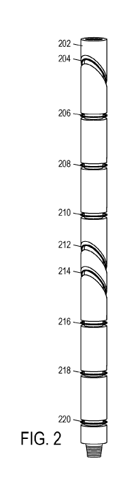
Referring now to Figure 2, an illustrative resistivity tool 202 is shown. The
tool 202 is
provided with one or more regions of reduced diameter for suspending a wire
coil. The wire coil is
placed in the region and spaced away from the tool surface by a constant
distance. To mechanically
support and protect the coil, a non-conductive filler material (not shown)
such as epoxy, rubber,
fiberglass, or ceramics may be used to fill in the reduced diameter regions.
The transmitter and
receiver coils may comprise as little as one loop of wire, although more loops
may provide
additional signal power. The distance between the coils and the tool surface
is preferably in the
range from 1/16 inch to 3/4 inch, but may be larger.
The illustrated resistivity tool 202 has six coaxial transmitters 206 (T5),
208 (T3), 210 (Ti),
216 (T2), 218 (T4), and 220 (T6), meaning that the axes of these transmitters
coincide with the
4
CA 02967919 2017-05-15
WO 2016/099504
PCT/US2014/071101
longitudinal axis of the tool. In addition, tool 202 has three tilted receiver
antennas 204 (R3), 212
(R1), and 214 (R2). The term "tilted" indicates that the plane of the coil is
not perpendicular to the
longitudinal tool axis. (Figure 3 shows an antenna that lies within a plane
having a normal vector at
an angle of 0 with the tool axis and at an azimuth of a with respect to the
tool face scribe line.
When 0 equals zero, the antenna is said to be coaxial, and when 0 is greater
than zero the antenna is
said to be tilted.) The spacing of the antennas may be stated in terms of a
length parameter x, which
in some embodiments is about 16 inches. Measuring along the longitudinal axis
from a midpoint
between the centers of receiver antennas 212 and 214, transmitters 210 and 216
are located at lx,
transmitters 208 and 218 are located at 2x, and transmitters 206 and 220 are
located at 3x. The
receiver antennas 212 and 214 may be located at x/4. In addition, a receiver
antenna 204 may be
located at plus or minus 4x.
The length parameter and spacing coefficients may be varied as desired to
provide greater
or lesser depth of investigation, higher spatial resolution, or higher signal
to noise ratio. However,
with the illustrated spacing, symmetric resistivity measurements can be made
with lx, 2x, and 3x
spacing between the tilted receiver antenna pair 212, 214, and the respective
transmitter pairs 210
(Ti), 216 (T2); 208 (T3), 218 (T4); and 206 (T5), 220 (T6). In addition,
asymmetric resistivity
measurements can be made with lx, 2x, 3x, 5x, 6x, and 7x spacing between the
tilted receiver
antenna 204 and the respective transmitter 206, 208, 210, 216, 218, and 220.
This spacing
configuration provides tool 202 with some versatility, enabling it to perform
deep (but asymmetric)
measurements for bed boundary detection and symmetric measurements for
accurate azimuthal
resistivity determination.
In some contemplated embodiments, the transmitters may be tilted and the
receivers may be
coaxial, while in other embodiments, both the transmitters and receivers are
tilted, though
preferably the transmitter and receiver tilt angles are different for at least
some of the transmitter-
receiver antenna pairs. Moreover, the roles of transmitter and receiver may be
interchanged while
preserving the usefulness of the measurements made by the tool. In operation,
each of the
transmitters is energized in turn, and the phase and amplitude of the
resulting voltage induced in
each of the receiver coils are measured. From these measurements, or a
combination of these
measurements, the formation resistivity can be determined.
In the illustrated embodiment of Figure 2, the receiver coils are tilted with
a 45 angle
between the normal and the tool axis. Angles other than 45 may be employed,
and in some
contemplated embodiments, the receiver coils are tilted at unequal angles or
are tilted in different
azimuthal directions. The tool 202 is rotated during the drilling (and
logging) process, so that
resistivity measurements can be made with the tilted coils oriented in
different azimuthal directions.
5
CA 02967919 2017-05-15
WO 2016/099504
PCT/US2014/071101
The 360 degrees of the azimuthal plane may be divided into M number of equal
sections or bins,
each bin covering 360/M degrees. For example, there may be 32 bins covering
11.25 degrees each,
and the tool 202 may log amplitude and phase measurements with different
transmitter/receiver
spacing and frequency for each bin.
Figure 4 is a flow chart of an illustrative method 400 of reducing the
shoulder effect
beginning at 402 and ending at 416. This method 400 may be performed by one or
more processors
in the tool alone or in cooperation with a surface computing facility. The
processors may execute
any step described in this disclosure as a result of executing software as
described below with
regard to Figure 5. At 404, the amplitude and phase measurements for each bin
at only one tool 202
position may be obtained.
At 406, resistivity and geosteering data may be derived based on the received
logging data
from a given position. Resistivity data may include values representative of
formation resistivity at
different azimuths and radial distances. Geosteering data may include the
difference between
measurements from the opposite azimuthal orientations of the tool 202, or may
instead be based on
some other azimuthal dependence of the tool measurements at that position.
The derived resistivity and geosteering data may be based on the average of
differences
between measurements of two transmitter/receiver pairs in at least one
embodiment. For example,
the phase and amplitude data received by receivers R1 and R2 based on
excitation of transmitter Ti
(the first transmitter/receiver pair being T1 R1, and the second
transmitter/receiver pair being Ti R2)
may be used in conjunction with Equations (1)-(4) below to derive compensated
resistivity and
geosteering data. The resistivity data may be derived by
AAn (k) = 201og(AR11 (k)) ¨ 201og(AR21 (k)) (1)
A0n(k)
= th COP R1T1 , R2T1( )
(2)
where A is amplitude, 0 is phase, R is a receiver, T is a transmitter, and k
is the bin number. For
example, ARin(k) is the amplitude of measurement on receiver R1 excited by
source Ti at bin k.
The average resistivity may be derived from the average difference of
amplitude and phase of the
measurements from different transmitter/receiver pairs, different frequencies,
and/or different bins.
The geosteering data may be derived by taking the difference between phase or
log
amplitude for a specific bin and the average phase or log amplitude for all
bins. The geosteering
data may be derived by:
aMP R1T1(k) = 20 log(AR (k)) ¨ 720 log(AR (i)) (3)
1772
phaR1T1(k) = OR1T1(k) - 312 0R1T1(i)
2 (4)
6
CA 02967919 2017-05-15
WO 2016/099504
PCT/US2014/071101
where amp is amplitude (derived), pha is phase (derived), A is amplitude, 0 is
phase, R is a
receiver, and T is a transmitter.
For the same formation, different values for resistivity or geosteering may be
derived for
the same location in the formation from transmitter/receiver pairs having
different antenna spacing
and/or different relative orientations. This separation may be due to the
anisotropy of the formation
or it may be due to the shoulder effect. Figure 6 illustrates such a
separation 600 in both the
resistivity data 602 and the geosteering data 604.
In order to determine if the shoulder effect is present, at 408, an
anisotropic inversion is
performed on the resistivity and geosteering data to determine a horizontal
resistivity (Rh), a
vertical resistivity (Rv), and dip angle (13) of the formation. Horizontal
resistivity is the formation
resistivity in the direction parallel to the layers of the formation. Vertical
resistivity is the formation
resistivity in the direction perpendicular to the layers of the formation. In
at least one embodiment,
average resistivities from different transmitter/receiver pairs, frequencies,
and bins are used in the
inversion.
First, a cost function equation is defined based on the difference between a
simulation result
from modeling the resistivity data and measurements from the tool 202. In at
least one
embodiment, the cost function is defined as C =11(S ¨ M)11 , where the 1111
operator is the L2
norm of the difference (misfit) vector, S is the simulation result (i.e., the
vector of predicted tool
measurements) from modeling the resistivity data, and M is the vector of
actual measurements
from the tool 202. For the anisotropic inversion, the model assumes that the
formation includes
only one homogenous layer in at least one embodiment. Next, the cost function
is minimized for
the parameters Rh, Rv, and dip angle, and the model is updated. More
iterations of minimizing the
cost function are performed until the parameters converge. The iteration can
be implemented using
a least squares method, the Marquardt-Levenberg method, the Gauss-Newton
method, and the like.
At 410, if the total residual error associated with the anisotropic inversion
is not above a
reference threshold, e.g. a tolerance of 10-5 for terminating the inversion at
each logging point,
then the shoulder effect is not present, and the method may end at 416.
However, if the total error
associated with the anisotropic inversion is above the reference threshold,
then the shoulder effect
is determined to be present and should be corrected.
At 412, a boundary location of the formation corresponding to the separation
of resistivities
is detected. Specifically, relative errors in the model of resistivity data
for various positions of a
sliding window along the formation are calculated. For example, one three-foot
window of data
may be incrementally shifted 2 inches of distance at a time along the
formation region having
7
CA 02967919 2017-05-15
WO 2016/099504
PCT/US2014/071101
residual errors above the threshold. These relative errors may vary
considerably, and the errors are
compared. The location of the window(s) having the largest relative error (or
local maxima) may be
identified as the boundary location. Some embodiments permit the
identification of multiple
boundary locations in the regions having residual errors above the threshold.
At 414, a vertical inversion is performed based on the boundary location and
results of the
first anisotropic inversion (from block 408). First, a cost function equation
is defined based on the
difference between measurements from the tool 202 and a simulation result from
modeling the
resistivity data. However, unlike the anisotropic inversion, the vertical
inversion model assumes
that the formation includes 2, 3, 4, or more layers in various embodiments.
For example, if 2 layers
are assumed, then a window having a fixed vertical size is centered around a
boundary location
identified at 412. In at least one embodiment, the fixed vertical size may be
3 feet (extending 1.5
feet above the identified boundary, and extending 1.5 feet below the
identified boundary).
Generally, the greater the fixed vertical size, the more layers that are
permitted to be in the
formation. A 3 foot window size would correspond to 2 layers.
Next, the cost function is minimized for the parameters Rh, Rv, dip angle, and
boundary
location and the model is updated. More iterations of minimizing the cost
function are performed
until the parameters converge. The iteration can be implemented using a least
squares method, the
Marquardt-Levenb erg method, the Gauss-Newton method, and the like. The
converged parameters
Rh, Rv, dip angle, and boundary location are more accurate than the derived
resistivity and
geosteering data because the vertical inversion accounts for the shoulder
effect, thereby reducing or
eliminating the separation between the resistivity parameters derived from
different transmitter-
receiver antenna pairs. As such, logs based on the converged parameters are
more accurate.
The resistivity measurement, resistivity logs, converged parameters, and/or
result of the
method 400 may be communicated to a user in at least one embodiment. For
example, the
measurement, logs, and/or results may be displayed, preferably while logging
(and drilling)
operations are ongoing, enabling the user to steer the drilling assembly with
the benefit of this
information. The display may be updated as each measurement is made, or
alternatively, may be
updated in stages, i.e., after a sufficient number of measurements have been
acquired for a given
tool position. Figure 5 illustrates a shoulder-reduction system 500 capable of
such display. The
system 500 includes a data processing system 50, which includes mediums such
as internal data
storage and memory having software (represented by removable information
storage mediums 52),
along with one or more processor cores that execute the software and perform
any of the steps
described in this disclosure. The software configures the system to interact
with a user via one or
8
CA 02967919 2017-05-15
WO 2016/099504
PCT/US2014/071101
more input/output devices (such as keyboard 54 and display 56 through which
any final or
intermediate value, diagram, information, or alert described in this
disclosure may be displayed).
The conservation of time and computational resources, in addition to the
increase in logging
accuracy, enabled by this disclosure allows for more productivity, better
interpretation of the logs,
and faster identification of hydrocarbon reserves. Specifically, the shoulder
effect may be identified
and corrected if present, and a geosteering trajectory may be derived based on
data from the
anisotropic or vertical inversion. The drillstring may be steered based on the
derived geosteering
trajectory. If not present, then logging may continue without correction.
Additionally, such
correction may be performed based on measurements from the tool 202 at only
one position, or
logging point, rather than multiple positions, or logging points.
Specifically, as discussed above,
multiple measurements of different spacing size and frequencies at one logging
point, using
multiple relative antenna orientations, may be used with long spacing sizes
used for measurements
farther in the formation and short spacing sizes used for measurements nearer
in the formation.
Similarly, low frequency data may be used for measurements farther in the
formation, while high
frequency data may be used for measurements nearer in the formation.
A resistivity logging method, includes: obtaining resistivity logging data
corresponding
to a resistivity logging tool's position in a formation position; performing
an anisotropic single-
layer inversion on the resistivity logging data to determine a horizontal
resistivity, a vertical
resistivity, and a dip angle of the formation at the tool's position;
detecting a location of a
boundary of the formation and performing a vertical multi-layer inversion
based on the
resistivity logging data in a window around said location, if a residual error
for the anisotropic
inversion exceeds a threshold; and displaying a log of at least one inversion
parameter from the
anisotropic inversion or the vertical inversion based on said residual error.
The method may include conveying the tool along a borehole through the
formation. The
method may include recording, on a non-transitory information storage medium,
a log of the
horizontal resistivity, vertical resistivity, or dip angle. Obtaining
resistivity logging data may
include obtaining resistivity logging data using multiple relative antenna
orientations. The
method may include deriving a geosteering trajectory based at least in part on
the at least one
inversion parameter. The drill string may be steered based on the derived
trajectory. Detecting
the location may include detecting the location of the boundary of the
formation only if an error
of the anisotropic inversion is above a threshold. Performing the vertical
inversion may include
performing the vertical inversion based on the location, horizontal
resistivity, vertical resistivity,
and dip angle only if an error of the anisotropic inversion is above a
threshold. Deriving average
resistivities may include: deriving an average resistivity for a transmitter
and receiver pair; and
9
CA 02967919 2017-05-15
WO 2016/099504
PCT/US2014/071101
deriving an average resistivity for another transmitter and receiver pair.
Performing the vertical
inversion may include minimizing a cost function until a parameter of the
formation converges
to a value. The parameter may be the location of the boundary. The cost
function may include
the difference between measurements from the logging data and a model of the
formation. The
method may include deriving geosteering data based on the logging data.
Detecting the location
may include detecting a location of a boundary of the formation based on the
geosteering data.
The logging tool may be a logging while drilling (LWD) tool.
A non-transitory computer-readable storage system includes instructions that,
when
executed, cause one or more processors to: obtain earth formation logging data
corresponding to
only one position of a logging tool; derive average resistivities for
locations in the formation
based on the logging data; perform an anisotropic inversion on the average
resistivities to
determine a horizontal resistivity, a vertical resistivity, and a dip angle of
the formation; detect a
location of a boundary of the formation based on the horizontal resistivity,
vertical resistivity,
and dip angle; perform a vertical inversion based on the location, horizontal
resistivity, vertical
resistivity, and dip angle; and output for display at least one of a result of
the vertical inversion
and a resistivity log based on the vertical inversion.
Detecting the location may cause the one or more processors to detect the
location of the
boundary of the formation only if an error of the anisotropic inversion is
above a threshold.
Performing the vertical inversion may cause the one or more processors to
perform the vertical
inversion based on the location, horizontal resistivity, vertical resistivity,
and dip angle only if
an error of the anisotropic inversion is above a threshold. Deriving average
resistivities may
cause the one or more processors to: derive an average resistivity for a
transmitter and receiver
pair; and derive an average resistivity for another transmitter and receiver
pair. Performing the
vertical inversion may cause the one or more processors to minimize a cost
function until a
parameter of the formation converges to a value. The parameter may be the
location of the
boundary. The cost function may include the difference between measurements
from the logging
data and a model of the formation. The one or more processors may be further
caused to derive
geosteering data based on the logging data. Detecting the location may cause
the one or more
processors to detect a location of a boundary of the earth formation based on
the geosteering
data. The logging tool may be a logging while drilling (LWD) tool.
While the present disclosure has been described with respect to a limited
number of
embodiments, those skilled in the art will appreciate numerous modifications
and variations
therefrom. It is intended that the appended claims cover all such
modifications and variations.