Note: Descriptions are shown in the official language in which they were submitted.
CA 02967932 2017-05-15
WO 2016/108840
PCT/US2014/072742
ELECTROMAGNETIC RANGING WITH AZIMUTHAL ELECTROMAGNETIC
LOGGING TOOL
Background
[00011 Magnetic ranging provides relative direction and distance of one well
with respect to
another. Several technologies for ranging are based upon launching a current
at a known
frequency from the earth's surface down the casing of a target well and
receiving a signal
radiated from that casing in a ranging well. Other types of excitation, such
as injecting a
current at a depth below the surface, are also used in the ranging
technologies.
100021 Such ranging operations may use a wireline tool to provide both
relative direction
and distance from the ranging well to the target well. During a drilling
operation, the drill
string is removed from the ranging well and the wireline tool is inserted in
order to
continually update the relative distance and direction of the ranging well to
the target well.
This may result in increased drilling time and greater cost due to the expense
of repeatedly
removing the drill string to insert the wirelinc tool.
Brief Description of the Drawings
[0003] FIG. 1 is a diagram showing an azimuthal electromagnetic (EM) logging
tool
according to various embodiments of the invention.
[0004] FIG. 2 is a flowchart showing methods for magnetic ranging in
accordance with
various embodiments of the invention.
[0005] FIG. 3 is a diagram of wireline and drilling systems using target well
ranging
according to various embodiments of the invention.
Detailed Description
[0006] Many embodiments described herein operate to provide information that
assists in
determining relative distance and direction to one well, such as a well being
drilled, to
another well. For example, such embodiments can be used when determining the
location of a
target well in relation to a ranging well.
[0007] A "target well" may be defined herein as a well, the location of which
is to be used
as a reference by another well. The other well may be defined as a "ranging
well". Other
embodiments may reverse this terminology since the embodiments are not limited
to any one
well-being the target well and any one well-being the ranging well.
CA 02967932 2017-05-15
WO 2016/108840
PCT/US2014/072742
[0008] Some embodiments use a wireline active ranging system to determine a
relative
distance and relative direction from a first well (e.g., ranging well) to a
second well (e.g.,
target well) until the ranging well reaches a desired distance. Thereafter, a
logging while
drilling (LWD) azimuthal electromagnetic (EM) logging system is used to
maintain or adjust
(e.g., increase, decrease) the desired distance while drilling. The desired
distance may be
defined as the distance at which the azimuthal EM logging tool can accurately
track the target
well. This distance may vary depending on the frequency used by the logging
tool as well as
the desired accuracy. A wireline operation may use the azimuthal EM logging
tool for
determining a range to a target well while the drilling operation may use the
tool for ranging
while drilling the ranging well.
[0009] The wireline ranging system is first used to provide distance and
direction to the
second well (target well) since it can provide a higher accuracy in
determination of distance
and longer range detection based on gradient measurements with very low
operating
frequency. However, since the wireline uses multiple trip-in and trip-out
drilling activities to
achieve the desired ranging requirements, the azimuthal EM logging system is
introduced to
guide the logging tool in the comet direction relative to the target well or
to maintain a
desired direction relative to the target well. Such azimuthal measurements are
sensitive to the
formations surrounding the tool as well as to the conductive casing in the
target well. This
combination of two systems can be utilized for three types of ranging
applications: 1) well
ranging with a desired and fixed separation, 2) well intersection, and 3) well
avoidance.
These examples will now be described in more detail.
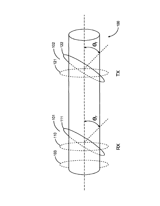
[0010] FIG. 1 is a diagram showing an azimuthal electromagnetic (EM) logging
tool 100
according to various embodiments of the invention. The logging tool 100
includes at least
one transmit coil antenna 102 and at least one receive coil antenna 101
separated axially
along the tool body 100. An embodiment may include one transmit coil antenna
102 and
multiple receive coil antennas 101, 103.
[0011] At least one of the antennas 101, 102 of the azimuthal EM logging tool
100 may be
tilted with respect to the longitudinal axis of the tool 100. FIG. 1 shows
different tilted
positions 110, 111 for the receive antenna 101 and different tilted positions
121, 122 for the
transmit antenna. The receive antenna 101 may be tilted by an angle 0, (e.g.,
450) and the
transmit antenna 102 may be tilted by an angle Ot (e.g., 45 ). These angles do
not have to be
equal. The antenna tilt enables an increase in azimuthal sensitivity. Having
only one of the
2
CA 02967932 2017-05-15
WO 2016/108840
PCT/US2014/072742
transmitter or receiver tilted provides a small but measurable sensitivity to
the target well
casing. Having both transmitter and the receiver tilted provides substantially
higher
sensitivity to the target well casing.
[0012] FIG. 2 is a flowchart showing methods for magnetic ranging in
accordance with
various embodiments of the invention. In many embodiments, a method begins at
block 201,
where a wireline ranging system is lowered into the ranging well. The wireline
ranging
system operates first to take EM ranging measurements, in block 203, and then
to calculate a
relative direction and distance to the target well, in block 205. This
calculated relative
direction and distance are used subsequently when the azimuthal EM logging
tool is used, to
determine if they are within a desired range, as determined by a frequency
used by the
azimuthal logging tool to take electromagnetic measurements. The ranging may
be
accomplished in various ways.
[0013] In LWD ranging applications, an oscillating magnetic field may be
induced in the
target well. This can be achieved using an EM source, such as the transmit
antenna 102 of
FIG. 1, transmitting an EM signal in the drilling well to induce current
signals in the target
well due to conductive casing properties in the target well. Received EM
azimuthal signals
corresponding to the induced current signals, as received by the receive
antenna 101 of FIG.
1, may be used to calculate the relative distance and direction from the
ranging well to the
target well. In wireline ranging applications, the current signals may be
directly applied to the
target well at surface or applied to the ranging well so that current flows
from the ranging
well to the target well through formations downhole. The receivers in the
ranging well may
be used to determine the magnetic fields due to the current signals in the
target well to
determine the relative distance and direction between the two wells.
[0014] In block 207, it is determined when the calculated distance is within a
desired
detection range. For example, the desired detection range may be a detection
range in which
the azimuthal EM tool may be able to accurately track the target well (i.e.,
the signal from the
target well is substantially larger than the measurement error ¨ large enough
to provide a
desired ranging accuracy with respect to the distance between the wells). For
example, the
distance at which the range accuracy is within 10 percent of the actual value
may be chosen
as the desired detection range. If the calculated distance is not
approximately equal to, or less
than, the desired detection range, the method continues to block 209 where the
well ranging
continues using the wireline system between drilling operations. Thus, the
method loops
3
CA 02967932 2017-05-15
WO 2016/108840
PCT/US2014/072742
through blocks 203-207 until the calculated distance has decreased to be
within the bounds
(i.e., equal to or less than) of the desired detection range.
[0015] The azimuthal EM tool may be used when the relative calculated distance
has been
reduced to approximately the desired detection range. In block 211, the
wireline logging
system may then be removed from the ranging well and the azimuthal EM tool is
used to
replace it The azimuthal EM logging tool is part of the drill string and may
be used to
maintain or adjust the relative distance between the ranging well and the
target well. Use of
the azimuthal EM logging tool for ranging, as opposed to a wireline logging
system, may
yield an advantage since the azimuthal EM logging tool measurements may be
made while
drilling, thus resulting in time and cost savings.
[0016] Various embodiments may be applied to different types of ranging
applications. For
example, one type of ranging includes acquiring a fixed separation between the
ranging well
(e.g., drilling well) and the target well within a particular depth range and
maintaining that
fixed separation during the drilling operations. This type of ranging may be
useful for
applications such as paralleling the target well path with the ranging well in
order to perform
a Steam-Assisted Gravity Drainage (SAGD) operation.
[0017] Another type of ranging includes acquiring the relative direction from
the ranging
well (e.g., drilling well) to the target well such that one can intersect the
target well, or avoid
the target well, as desired. In this type of ranging, the azimuthal EM logging
tool provides
directions in real-time to the drilling system in order to steer the drill bit
toward, or away
from, the target well. Once the distance has decreased sufficiently, the
azimuthal EM logging
tool itself is capable of providing distance/direction from the drilling well
to the target well
for as long as the separation between the two wells is within detection range
of the EM
system.
[0018] In block 213, the azimuthal EM logging tool operates at the same
measured depth as
the last wireline measurement so that EM measurements are taken, and compared
in block
215 with the calculated distance and direction from the wireline system
(acquired as part of
the activity for block 205 of the method). In block 217, the relative
direction and distance to
the target well may be obtained to calibrate LWD ranging and azimuth
calculations obtained
from the wireline system. In block 219, the azimuthal EM logging tool may be
used for well
ranging to provide relative direction and distance between the two wells
without using the
wireline logging system.
4
CA 02967932 2017-05-15
WO 2016/108840
PCT/US2014/072742
[0019] The calibration of the LWD signal to distance can be accomplished by
collecting a
number of distance measurements using both the wireline logging tool and the
azimuthal EM
logging tool, and estimating the parameters of a calibration function. If the
wireline range
measurements are denoted as clw(zi) at depth zi and the azimuthal EM tool
range
measurements are denoted as di(z1) at depth Z, a mapping function f, with
mapping
parameter vector p can be constructed to map any LWD data to wireline data as
follows:
d(z1) = p) (1)
[0020] Parameter vectorp can be found by looking for the value ofp that
minimizes the
mismatch between the wireline data and mapped LWD data as follows:
p = argminp(d(zi) - f(di(zi), p)) (2)
[0021] Once the value of the p vector is calculated, any subsequent azimuthal
EM logging
tool measurements can be calibrated as follows:
dlcal(Z) = fid 1(Z i) /3) (3)
where diazd is the corrected LWD range measurement at depth zi.
[0022] One selection for mapping function f , among others that may be made,
is as follows.
In this case, the selection provides the equivalent to a multiplicative
correction where A is an
azimuth measurement:
f(A, p) = Ap (4)
[0023] The values for the azimuth to the target well may be corrected the same
way as
described above, using a different mapping function and a parameter vector. In
the case of
azimuth, an additive correction of the formf(A, p)=A+p may be used. Other
forms of
mapping parameter vector p as function of azimuth angle (1), such as f(A, p,
(1))=
A(4)P(0) '31" ./(A 13, (1))--= A((1))+13(0), may be used in the mapping
function. It is
noted here that the calibration may be applied multiple times in case there
are
expected/measured changes in the target casing properties (i.e., casing or
tubing diameter or
thickness changes based on well completion history of the target). Calibration
may also be re-
applied when abnormalities in the signal are observed (i.e., abrupt and
unexpected shifts,
large amounts of noise).
[0024] FIG. 3 is a diagram of wireline 365 and drilling 364 systems using
target well
ranging according to various embodiments of the invention. The wireline system
365 may use
a wireline ranging tool (e.g., azimuthal EM logging tool 100) for determining
a range to a
target well while the drilling system 364 may use the azimuthal EM logging
tool 100 for
ranging while drilling the ranging well.
[0025] Either of the wells 306, 390 may be the ranging well while the other is
the target
well. However, for purposes of illustration, the well 306 shown under
construction is the
ranging well as it is being constructed to range from the other well 390
(i.e., target well).
[0026] Drilling of oil and gas wells is commonly carried out using a string of
drill pipes
connected together so as to form a drilling string that is lowered through a
rotary table 310
into a wellbore or borehole 312. A system 364 may form a portion of a drilling
rig 302
located at the surface 304 of a well 306. The drilling rig 302 may provide
support for a drill
string 308. The drill string 308 may operate to penetrate a rotary table 310
for drilling a
borehole 312 through subsurface geological formations 1114. The drill string
308 may
include a Kelly 316, drill pipe 318, and a bottom hole assembly 320, perhaps
located at the
lower portion of the drill pipe 318.
[0027] The bottom hole assembly 320 may include drill collars 322, a downhole
tool 324,
and a drill bit 326. The drill bit 326 may operate to create a borehole 312 by
penetrating the
surface 304 and subsurface geological formations 314. The downhole tool 324
may comprise
any of a number of different types of tools including the azimuthal EM logging
tool 100.
[0028] During drilling operations, the drill string 308 (perhaps including the
Kelly 316, the
drill pipe 318, and the bottom hole assembly 320) may be rotated by the rotary
table 310. In
addition to, or alternatively, the bottom hole assembly 320 may also be
rotated by a motor
(e.g., a mud motor) that is located downhole. The drill collars 322 may be
used to add weight
to the drill bit 326. The drill collars 322 may also operate to stiffen the
bottom hole assembly
320, allowing the bottom hole assembly 320 to transfer the added weight to the
drill bit 326,
6
CA 2967932 2018-09-07
CA 02967932 2017-05-15
WO 2016/108840
PCT/US2014/072742
and in turn, to assist the drill bit 326 in penetrating the surface 304 and
subsurface formations
314.
[0029] During drilling operations, a mud pump 332 may pump drilling fluid
(sometimes
known by those of skill in the art as "drilling mud") from a mud pit 334
through a hose 336
into the drill pipe 318 and down to the drill bit 326. The drilling fluid can
flow out from the
drill bit 326 and be returned to the surface 304 through an annular area 340
between the drill
pipe 318 and the sides of the borehole 312. The drilling fluid may then be
returned to the mud
pit 334, where such fluid is filtered. In some embodiments, the drilling fluid
can be used to
cool the drill bit 326, as well as to provide lubrication for the drill bit
326 during drilling
operations. Additionally, the drilling fluid may be used to remove subsurface
formation 314
cuttings created by operating the drill bit 326.
[0030] In various embodiments, the azimuthal EM logging tool 100 may be
included in a
wireline ranging tool 370 coupled to a logging cable 374 such as, for example,
for wireline
applications. The tool body 370 containing the tool 100 can include
electronics to initiate and
collect measurements. Such electronics can include a processing unit to
provide analysis of
data over a standard communication mechanism for operating in a well.
Alternatively,
electronics can include a communications interface to provide measurement
signals collected
by the tool 100 to the surface over a standard communication mechanism for
operating in a
well, where these measurements signals can be analyzed at a processing unit
392 at the
surface to provide analysis of data. The logging cable 374 may be realized as
a wireline
(multiple power and communication lines), a mono-cable (a single conductor),
or a slick-line
(no conductors for power or communications), or other appropriate structure
for use in the
borehole 390.
[0031] As an example of an operation, the wireline ranging tool 370 (e.g.,
azimuthal EM
logging tool 100) is configured to take ranging measurements from which a
relative distance
and direction to between a target well 390 and a ranging well 306 are
calculated until a
desired distance to the target well is reached. The desired distance varies
with a frequency
used by the azimuthal EM logging tool to take electromagnetic measurements.
The azimuthal
EM logging tool 100, disposed on the drill string in the ranging well 306
after the desired
distance is reached, is configured to take electromagnetic measurements that
are compared
with the calculated relative distance and direction to calibrate the azimuthal
EM logging tool
100 to provide control of the drilling operation to parallel the target well
390, intersect the
target well, or avoid the target well. A controller 393 is configured to
accept the relative
7
distance and direction and the electromagnetic measurements and determine a
calibration
function to provide control of the drilling operation.
[0032] Many embodiments may be realized. Several examples will now be
described.
[0033] Example 1 is a method for ranging between a target well and a ranging
well, the
method comprising determining relative distance and direction from the ranging
well to the
target well with a wireline tool; calibrating an azimuthal electromagnetic
logging tool to the
wireline tool in response to a comparison of electromagnetic measurements with
the relative
distance and direction; and using the azimuthal electromagnetic logging tool
on a drill string
to maintain or adjust the relative distance while drilling.
[0034] In Example 2, the subject matter of Example 1 can further include using
the
azimuthal electromagnetic logging tool to decrease the relative distance while
drilling
comprises intersecting with the target well.
[0035] In Example 3, the subject matter of Example 1 can further include using
the
azimuthal electromagnetic logging tool to maintain the relative distance while
drilling
comprises paralleling the target well to perform a well avoidance operation.
[0036] In Example 4, the subject matter of Examples 1-3 can further include
determining
the relative distance and direction from the ranging well to the target well
with the wireline
tool comprises calculating the relative distance and direction in response to
an
electromagnetic signal received from the target well.
[0037] In Example 5, the subject matter of Examples 1-4 can further include
performing
electromagnetic measurements from the drill string; comparing the
electromagnetic
measurements to the calculated relative distance and direction; and
calibrating logging while
drilling ranging and azimuth calculations to the wireline tool.
[0038] In Example 6, the subject matter of Examples 1-5 can further include
determining
the relative distance and direction from the ranging well to the target well
with the wireline
tool comprises taking electromagnetic ranging measurements with the wireline
tool, the
method further comprising continuing to take electromagnetic ranging
measurements with the
wireline tool until the distance is reached.
[0039] In Example 7, the subject matter of Examples 1-6 can further include
using an
azimuthal electromagnetic logging tool on a drill string to maintain the
relative distance while
drilling or decrease the relative distance while drilling comprises
transmitting an
electromagnetic signal from a transmitting antenna and receiving a reflected
electromagnetic
8
CA 2967932 2018-09-07
CA 02967932 2017-05-15
WO 2016/108840
PCTAUS2014/072742
signal at a receiving antenna wherein one of the transmitting antenna or the
receiving antenna
are tilted with respect to a longitudinal axis of the drill string.
[0040] In Example 8, the subject matter of Examples 1-7 can further include
using an
azimuthal electromagnetic logging tool on a drill string to maintain the
relative distance while
drilling or decrease the relative distance while drilling comprises
transmitting an
electromagnetic signal from a transmitting antenna and receiving a reflected
electromagnetic
signal at a receiving antenna wherein both of the transmitting antenna and the
receiving
antenna are tilted with respect to a longitudinal axis of the drill string.
[0041] Example 9 is a method for ranging between a target well and a ranging
well, the
method comprising: using a wireline tool in the ranging well to perform
electromagnetic
ranging measurements on the target well; calculating a relative distance and a
relative
direction from the ranging well to the target well; when a desired distance is
reached between
the ranging well and the target well, using an azimuthal electromagnetic tool
in a drill string
to take electromagnetic measurements; calibrating the azimuthal
electromagnetic tool to the
wireline tool by comparing the electromagnetic measurements to the calculated
relative
distance and relative direction; and drilling in the ranging well while using
the azimuthal
electromagnetic tool to parallel the target well, intersect the target well,
or avoid the target
well.
[0042] In Example 10, the subject matter of Example 9 can further include
collecting a
plurality of relative distance measurements using the wireline tool and the
azimuthal
electromagnetic tool; and estimating parameters of a calibration function
using the plurality
of relative distance measurements.
[0043] In Example 11, the subject matter of Examples 9-10 can further include
dw(v) =
f(d1(zi), p) wherein dW(ZO represents relative distance measurements from the
wireline
tool at a depth zi, d/(zi) represents relative distance measurements from the
azimuthal
electromagnetic tool at the depth zi, f represents a mapping function with
mapping parameter
vector p.
[0044] In Example 12, the subject matter of Examples 9-11 can further include
wherein the
mapping parameter vector p is determined byp = argminp(dw(zi) - f(d1(zi), p)).
9
CA 02967932 2017-05-15
WO 2016/108840
PCT/US2014/072742
[0045] In Example 13, the subject matter of Examples 9-12 can further include
calibrating
azimuthal electromagnetic tool measurements by diCai(ZO =f(dl(zi), p) wherein
diCakz0 is a corrected LWD range measurement at the depth zi.
[0046] In Example 14, the subject matter of Examples 9-13 can further include
wherein the
mapping function comprisesf(A, p) = Ap wherein A is an azimuth measurement.
[0047] In Example 15, the subject matter of Examples 9-14 can further include
wherein the
mapping parameter vector p is a function of azimuth angle 41.
[0048] In Example 16, the subject matter of Examples 9-15 can further include
wherein the
mapping function comprisesf(A, p, 0)= A(0)p(0) orf(A, p, 0)= A(4))+p(0).
[0049] Example 17 is a system comprising: a wireline ranging tool to be used
in a ranging
well, the wireline ranging tool configured to take ranging measurements from
which relative
distance and direction to a target well are calculated until a desired
distance to the target well
is reached; and an azimuthal electromagnetic logging tool to be used on a
drill string in the
ranging well after the desired distance is reached, the azimuthal
electromagnetic logging tool
configured to take electromagnetic measurements that are compared with the
calculated
relative distance and direction to calibrate the azimuthal electromagnetic
logging tool to
provide control of a drilling operation to parallel the target well, intersect
the target well, or
avoid the target well.
[0050] In Example 18, the subject matter of Example 17 can further include the
azimuthal
electromagnetic logging tool comprising a transmit coil antenna and a receive
coil antenna
wherein at least one of the transmit coil antenna or the receive coil antenna
are tilted with
respect to a longitudinal axis of the wireline logging tool.
[0051] In Example 19, the subject matter of Examples 17-18 can further include
the
azimuthal electromagnetic logging tool comprising a transmit coil antenna and
a plurality of
receive coil antennas wherein the transmit coil antenna and the plurality of
receive coil
antennas are tilted with respect to a longitudinal axis of the wireline
logging tool.
[0052] In Example 20, the subject matter of Examples 17-19 can further include
functionality wherein the desired distance varies with a frequency used by the
azimuthal
logging tool to take electromagnetic measurements.
[0053] In Example 21, the subject matter of Examples 17-20 can further include
a
controller configured to accept the relative distance and direction and the
electromagnetic
CA 02967932 2017-05-15
WO 2016/108840
PCIUUS2014/072742
measurements and determine a calibration function to provide control of the
drilling
operation.
[0054] The accompanying drawings that form a part hereof, show by way of
illustration, and
not of limitation, specific embodiments in which the subject matter may be
practiced. The
embodiments illustrated are described in sufficient detail to enable those
skilled in the art to
practice the teachings disclosed herein. Other embodiments may be utilized and
derived
therefrom, such that structural and logical substitutions and changes may be
made without
departing from the scope of this disclosure. This Detailed Description,
therefore, is not to be
taken in a limiting sense, and the scope of various embodiments is defined
only by the
appended claims, along with the full range of equivalents to which such claims
are entitled.
11