Note: Descriptions are shown in the official language in which they were submitted.
CA 02969322 2017-05-30
WO 2016/108909 PCT/US2014/073052
FORMATION LOGGING USING MULTICOMPONENT SIGNAL-BASED
MEASUREMENT OF ANISOTROPIC PERMITTIVITY AND RESISTIVITY
BACKGROUND
In the field of petroleum well drilling and logging, resistivity logging tools
are
frequently used to provide an indication of the electrical resistivity of rock
formations
surrounding an earth borehole. (Such information regarding resistivity is
useful in ascertaining
the presence or absence of hydrocarbons.) A typical electromagnetic
resistivity logging tool
includes a transmitter antenna and multiple receiver antennas located at
different distances
io from
the transmitter antenna along the axis of the tool. The transmitter antenna
creates
electromagnetic fields in the surrounding formation, which in turn induce a
voltage in each
receiver antenna. Due to geometric spreading and absorption by the surrounding
earth
formation, the induced voltages in the receiving antennas have different
phases and
amplitudes.
Experiments have shown that the phase difference (4130) and amplitude ratio
(attenuation,
A) of the induced voltages from any two receiver antennas are indicative of
the resistivity of
the formation. The depth of investigation (as defined by an averaged radial
distance from the
tool axis) to which such a resistivity measurement pertains is a function of
the frequency of the
transmitter and the distance from the transmitter to the mid-point between the
two receivers.
Thus, one may achieve multiple radial depths of investigation of resistivity
either by providing
multiple transmitters at different distances from the receiver pair or by
operating a single
transmitter at multiple frequencies, or both.
Many formations are electrically anisotropic, a property which is generally
attributable
to fine layering during the sedimentary build-up of the formation. Hence, in a
formation
zs
coordinate system oriented such that the x-y plane is parallel to the
formation layers and the z
axis is perpendicular to the formation layers, resistivities Rx and Ry in
directions x and y,
respectively, are the same, but resistivity R., in the z direction may be
different from Rx and R.
Thus, the resistivity in a direction parallel to the plane of the formation
(i.e., the x-y plane) is
known as the horizontal resistivity, Rh, and the resistivity in the direction
perpendicular to the
plane of the formation (i.e., the z direction) is known as the vertical
resistivity, R. One
measure of formation anisotropy is the index of anisotropy, i, which is
defined as
11 = [RvilZhil/z=
1
CA 02969322 2017-05-30
WO 2016/108909 PCT/1JS2014/073052
The relative dip angle, 0, is the angle between the tool axis and the normal
to the plane
of the formation. Resistivity anisotropy and relative dip angle each have
significant effects on
resistivity logging tool measurements. As a result, resistivity logging
systems should account
for formation anisotropy and relative dip if accurate resistivity logs are to
be obtained. To
facilitate the determination of the anisotropic resistivity parameters (Rh, R,
and 0), at least one
of the transmit or receive antennas is tilted or oriented transversely to the
tool axis to introduce
an azimuthal sensitivity, and in practice it is becoming common to configure
multiple ones of
the transmitter and receiver antennas as multi-component antennas. Moreover,
at least some
multi-component resistivity logging systems also acquire measurements using
multiple signal
frequencies.
Often, an inversion process is employed to derive the formation parameters
from the
resistivity tool measurements. In an inversion process, the tool measurements
are compared to
synthetic measurements derived from a parameterized formation model, and the
model
parameters are adjusted until the synthetic measurements match the tool
measurements.
Though the increased number of measurements offered by multi-spacing, multi-
frequency, and
multi-component logging tools creates the potential for increased model
complexity and
improved characterization accuracy, the large parameter space associated with
unduly complex
models renders them computationally infeasible and prone to numerical errors
from
unnecessary parameters.
Thus, when the existing inversion processes fail to accurately characterize
certain
formations, it is often unwise to pursue the conventional approach of merely
increasing the
number of model parameters and/or increasing the number of measurements being
operated on
by the inversion process. Rather, a more selective approach is called for.
BRIEF DESCRIPTION OF THE DRAWINGS
Accordingly, there are disclosed herein specific formation logging systems and
methods that invert single-frequency or multi-frequency multicomponent signal
measurements
using a formation model that includes anisotropic permittivity parameters. In
the drawings:
Fig. 1 is a schematic illustration of a logging while drilling (LWD)
environment.
Fig. 2 is a schematic illustation of a wireline logging environment.
Fig. 3A is a schematic depiction of an illustrative antenna configuration for
an
electromagnetic wireline tool.
2
CA 02969322 2017-05-30
WO 2016/108909 PCT/US2014/073052
Fig. 3B is a simplified schematic representation of a multicomponent transmit-
receive
antenna arrangement.
Fig. 3C is a perspective view of an illustrative triaxial antenna.
Fig. 3D is a schematic depiction of an illustrative tilted antenna
configuration for an
electromagnetic LWD tool.
Fig. 3E is a function block diagram of an illustrative electromagnetic logging
system.
Fig. 4A is a schematic representation of the coordinate axes for a sedimentary
earth
formation.
Fig. 4B is a schematic representation of grain-shape effects on ion mobility.
Fig. 5 is a schematic representation of a formation model with anisotropic
permittivity.
Fig. 6 is a flow diagram of an illustrative formation logging method.
It should be understood, however, that the specific embodiments given in the
drawings and
detailed description thereto do not limit the disclosure. On the contrary,
they provide the
foundation for one of ordinary skill to discern the alternative forms,
equivalents, and
modifications that are encompassed together with one or more of the given
embodiments in the
scope of the appended claims.
DETAILED DESCRIPTION
The following disclosure provides electromagnetic logging systems and methods
using
a formation model that efficiently provides enhanced inversion accuracy by
accounting for
anisotropic formation permittivity. With such accounting, the inversion can be
performed
using measurements at a single frequency, though some embodiments employ
single-
frequency inversion at each of multiple measurement frequencies to obtain a
dispersion curve
for the formation, and still other embodiments employ simultaneous multi-
frequency, multi-
component inversion while accounting for anisotropic formation permittivity.
The inversion
parameters include formation dip, anisotropic resistivity (Rh, R.õ), and
anisotropic permittivity
(Eh, Ev), enabling fluid saturations and rock types to be determined even in
the presence of
anomalies such as pyrite deposits and other sources of Maxwell-Wagner
polarization.
Fig. 1 shows a suitable context for describing the operation of the disclosed
systems
and methods. In the illustrated logging while drilling (LWD) environment, a
drilling platform
102 is equipped with a derrick 104 that supports a hoist 106 for raising and
lowering a drill
string 108 through the well head 112. A top drive 110 rotates the drill string
108 to drill the
3
CA 02969322 2017-05-30
WO 2016/108909 PCT/US2014/073052
borehole as far as the length of the drill string allows. The drill string 108
is periodically
extended by temporarily anchoring the drill string 108 at the well head 112
and using the hoist
106 to position and attach new drill pipe sections with threaded connectors
107.
Connected to the lower end of the drill string 108 is a drill bit 114. As the
drill bit 114
rotates, it creates a borehole 120 that passes through various formations 121.
A pump 116
circulates drilling fluid through a supply pipe 118 to top drive 110, through
the interior of drill
string 108, through orifices in drill bit 114, back to the surface via the
annulus around drill
string 108, and into a retention pit 124. The drilling fluid transports
cuttings from the borehole
into the pit 124 and aids in maintaining the integrity of the borehole 120.
Drilling fluid, often referred to in the industry as "mud", is often
categorized as either
water-based or oil-based, depending on the solvent. Oil-based muds are
generally preferred for
drilling through shaley formations, as water-based muds have been known to
damage such
formations.
An electromagnetic logging tool 126 is integrated into the bottomhole assembly
129
near the drill bit 114. The electromagnetic logging tool 126 may take the form
of a drill collar,
i.e., a thick-walled tubular that provides weight and rigidity to aid the
drilling process. As the
drill bit 114 extends the borehole 120 through the formations, the
electromagnetic logging tool
126 (possibly in cooperation with other sensors in the bottomhole assembly
129) collects
multicomponent signal measurements and measurements of the tool orientation
and position,
borehole size, drilling fluid resistivity, and various other drilling
conditions.
The orientation measurements may be performed using an orientation indicator,
which
may include magnetometers, inclinometers, and/or accelerometers, though other
sensor types
such as gyroscopes may be used. Preferably, the orientation indicator includes
a 3-axis
fluxgate magnetometer and a 3-axis accelerometer. As is known in the art, the
combination of
those two sensor systems enables the measurement of the rotational
("toolface") angle,
borehole inclination angle (aka "slope"), and compass direction ("azimuth").
In some
embodiments, the toolface angle and borehole inclination are calculated from
the
accelerometer sensor output. The magnetometer sensor outputs are used to
calculate the
borehole azimuth. With the toolface angle, the borehole inclination, and the
borehole azimuth
information, the electromagnetic logging tool measurements can be used to
steer the bit to and
along the desired formation layer.
In wells employing acoustic telemetry for LWD, the electromagnetic logging
tool 126
and other downhole sensors are coupled to the telemetry module 128 having an
acoustic
4
CA 02969322 2017-05-30
WO 2016/108909 PCT/US2014/073052
telemetry transmitter that transmits telemetry signals in the form of acoustic
vibrations in the
tubing wall of drill string 108. An acoustic telemetry receiver array 130 may
be coupled to
tubing below the top drive 110 to receive transmitted telemetry signals. One
or more repeater
modules 132 may be optionally provided along the drill string to receive and
retransmit the
telemetry signals. Alternative LWD telemetry techniques exist and can be
employed, including
mud pulse telemetry, electromagnetic telemetry, and wired drillpipe telemetry.
Many telemetry
techniques also offer the ability to transfer commands from the surface to the
bottomhole
assembly 129, thereby enabling adjustment of the tool's configuration and
operating
parameters. In some embodiments, the telemetry module 128 also or
alternatively stores
measurements for later retrieval when the bottomhole assembly 129 returns to
the surface.
A drilling equipment interface 48 facilitates communication between the
surface
components of the telemetry system and a processing system 50, shown here in
the form of a
desktop computer coupled to the drilling equipment interface 48 via a cable
49. In other
embodiments, the processing system 50 may be a tablet, laptop computer, a
remote processing
center, or even a virtual computer, any of which may be coupled to retrieve
the logging tool
measurements via a computer network and/or a wireless communications link.
Software
(shown in Fig. 1 as portable information storage media 52), once loaded into
internal memory
and executed by the processor(s), configures the processing system 50 to
derive estimated
formation parameters from the logging tool measurements and to responsively
provide a visual
representation of the estimated parameters on a display 56, a printer, or
other device for
providing a perceptible output. A keyboard 54 or other input device enables a
user to interact
with the processing system and thereby achieve at least some control of the
displayed
information to facilitate a greater understanding of the presented
information. Normally the
formation parameter estimates are presented as formation logs having multiple
tracks, each
track displaying a formation parameter's dependence on depth or borehole
position.
At various times during the drilling process, the drill string 108 is removed
from the
borehole as shown in Fig. 2. Once the drill string has been removed, logging
operations can be
conducted using a wireline logging tool 134, i.e., a sensing instrument sonde
suspended by a
cable 142 having conductors for transporting power to the tool and telemetry
from the tool to
the surface. An electromagnetic logging portion of the logging tool 134 may
have centralizing
arms 136 that center the tool within the borehole as the tool is pulled
uphole. A logging facility
144 collects measurements from the logging tool 134, and includes a processing
system 50 for
processing and storing the measurements gathered by the logging tool.
5
CA 02969322 2017-05-30
WO 2016/108909 PCT/US2014/073052
Fig. 3A shows an illustrative electromagnetic wireline logging tool 134 having
antennas for acquiring multicomponent signal measurements as a function of
position along
the borehole. A multi-component transmit antenna 302 includes three orthogonal
antennas that
can be operated in sequence to generate electromagnetic fields in the
surrounding formation,
the propagation and attenuation of those fields varying in accordance with the
electrical
characteristics of the formation. Axial antennas 304, 306, and/or
multicomponent receive
antennas 308, 310, 312, 314, enable multiple measurements of each of the
resulting fields. The
transmit-receive antenna spacings are design parameters that may be adjusted
by the
manufacturer in accordance with the desired measurement resolution and depth
of
investigation for the tool. The tool may acquire attenuation and phase
measurements of each
receive antenna's response to transmit antenna 302. In certain alternative
embodiments, the
tool measures in-phase and quadrature-phase components of the receive signals
rather than
measuring amplitude and phase. In either case, these measurements are
collected and stored as
a function of the tool's position and rotational orientation in the borehole.
The illustrated tool has receive antennas 304 and 306 coaxial with the tool,
making
them parallel to the Z-axis component of the transmit antenna 302. Each
multicomponent
receive antenna 308-314 is, in accordance with the model shown in Fig. 3B,
oriented to
maintain each of its components parallel to the corresponding component of the
transmit
antenna 302. Each component of the multicomponent receive antenna includes a
main coil and
a bucking coil each oriented parallel to the corresponding transmitter coil,
and spaced apart
along the tool's axis. In Fig. 3B, the orthogonal triad of transmitter coils
Tx, Ty, Tz, represent
magnetic dipole antennas oriented parallel to the tool's X, Y, and Z axes
respectively (the
tool's coordinate system). An orthogonal triad of main receiver coils Rxm yym
,Rzm similarly
represent magnetic dipole antennas oriented along these axes, as do a triad of
bucking receiver
coils e. ,Ryb,Rzb . The tool dimensions and antenna spacings are subject to a
great deal of
variation depending on the desired tool properties. The distance between the
main receive and
bucking coils may be on the order of 0.25 m, while the spacing of the transmit
coil to the
midpoint between the main receive and bucking coil pairs may vary from about
0.4 m to over
10 m.
In the illustrative tool embodiments, each of the antennas surrounding the
tool is
mounted in a recess and protected by a non-conductive filler material and/or a
shield having
apertures of a non-conductive material. The tool body may be primarily
composed of a highly
6
CA 02969322 2017-05-30
WO 2016/108909 PCT/US2014/073052
conductive material, such as steel. As shown in Fig. 3C, the antenna coil
triads may each be
wound on a winding form 322 around an inner tubular 324. The inner tubular
houses the tool
electronics and wiring. Sensitivity to magnetic fields along an X-axis is
provided by two coils
326, 328, while sensitivity along a Y-axis is provided by two coils 330, 332.
A co-axial coil
334 provides sensitivity along a Z-axis. Other triaxial antenna configurations
are also suitable
and may be employed.
Returning to Fig. 3B, the main receiver triad is spaced at a distance Lõ, from
the
transmitter triad, and the bucking receiver triad is spaced at a distance Lb
from the transmitter
triad. The signal measurements of each coil in the bucking receiver triad can
be subtracted
from the corresponding coil in the main receiver triad to eliminate the direct
field signal from
the transmitter and thereby increase sensitivity to formation properties. As
explained by Moran
and Gianzero, in "Effects of Formation Anisotropy on Resistivity Logging
Measurements"
Geophysics, Vol. 44, No. 7, p. 1266 (1979), the magnetic field h in the
receiver coils with a
given signal frequency can be represented in terms of the magnetic moments m
at the
transmitters and a coupling matrix C:
h = C m
(1)
In express form, equation (1) is:
- _
Cõ Cõ Cxz
H = C CYY C M (2)
Yx zz Y
C, M
H C C C_
_ z_ _ zx z _ _ z _
where Mx, My, and Mz are the magnetic moments (proportional to transmit signal
strength)
created by transmitters Tx, Ty, and Tz, respectively. Hx, Hy, Hz are the
magnetic fields
(proportional to receive signal strength) at the receiver antennas Rx, Ry, and
Rz, respectively.
In the antenna configuration of Fig. 3B, if each transmitter is fired in turn,
and signal
measurements are made at each receiver in response to each firing, nine
differential
measurements (TiRmi-TiRb, , ij E tx,y,z1) are obtained. These nine frequency-
dependent
transmit-receive antenna coupling measurements enable the determination of a
complete
coupling matrix C. (Ci, =a, Vij, where i is the index for receiver axis x, y,
z, and j is the index
for transmitter axis x, y, z, aj is a constant determined by the tool design,
and V,i is a complex
value representing the signal amplitude and phase shift measured by receiver i
in response to
the firing of transmitter j.) Thus for each signal frequency and antenna
spacing employed, the
measured voltage tensor can be expressed:
7
CA 02969322 2017-05-30
WO 2016/108909 PCT/US2014/073052
IV Vy V \
xx x
V = (V. )(3x3) = V VY (3)
V =
.17x Y
V V V
.7 -
""
As in conventional induction logging, the elements of the measured voltage
tensor can
often be calibrated into an apparent conductivities to obtain the following
apparent-
conductivity tensor expression:
CI a
5
= (c0(30) = Cr). GP Cr
(4)Y= =
U_
zy ,
As with the coupling matrix elements, the apparent conductivities are each
related to the
corresponding measured voltage tensor elements via a calibration factor Kij:
au = KuVo ,
(5)
where Ku are the calibration factors as determined by a calibration
experiment. With a tool
lo design that employs collocated transmit antennas and collocated
receive antennas, the
calibration factors for a given transmit-receive antenna subarray usually
satisfy the following
relations:
Kxx Kyy = K= xy = K= yx
(6a)
Kxz Kyz = K= zx K= zy
(6b)
yielding only three independent calibration factors per frequency: K., Kzz,
and Kxz.
Calibration may be done in such a way that the conductivity reading of the
tool in
homogeneous formation without the borehole would match the true conductivity
of the
formation.
As with the voltage measurements, the coupling matrix elements may be complex
valued. The coupling matrix elements may be expressed:
= +j(DEo
(7)
where o-r is the real-valued component of the apparent conductivity, co is the
angular frequency,
co is the vacuum permittivity, and E is the formation's relative permittivity
(also known as the
dielectric constant). In a horizontally laminated formation, the effective
horizontal conductivity
is a volumetric average of the layer conductivities, but the effective
vertical conductivity is an
inverted volumetric average of the layers' inverse conductivities. The
inversions cause the
permittivity to affect the tool's measurement of the vertical conductivity's
real-valued
component, particularly at frequencies above about 100 kHz.
While conductivity and resistivity are not interchangeable (their values are
inverses of
8
CA 02969322 2017-05-30
WO 2016/108909 PCT/1JS2014/073052
each other), they are treated herein as functional equivalents because
knowledge of either one
dictates the value of the other. Whether the tool measurements are expressed
in terms of a
coupling matrix, a measured voltage tensor, an apparent conductivity tensor,
or the equivalent
resistivity values, they are herein referred to as multicomponent signal
measurements, and they
are expected to have frequency dependences that may be herein referred to as
dispersion
curves. (The term "dispersion curve" includes frequency dependence of either
or both
conductivity and permittivity values.)
The triaxial antennas shown in Figs. 3A-3C are shown for explanatory purposes;
they
are not required to obtain the described multicomponent signal measurements.
For example,
Fig. 3D shows an illustrative tilted antenna LWD tool 126 that when rotated,
acquires
measurements from which the orthogonal multicomponent signal measurement
values can be
determined. Tilted receiver antennas 335 and 336 are co-located and tilted
about 45 in
opposite azimuthal directions. A first pair of transmitter coils 337 and 339
are equally spaced
in opposite directions from the receiver antennas by about 32 inches, and a
second pair of
transmitter coils 338 and 340 are equally spaced in opposite directions from
the receiver
antennas by about 48 inches. The transmitter coils in each pair are tilted in
opposite azimuthal
directions. Further details about the operation and processing performed by
the illustrative tool
can be found in international application WO 2011/129828 Al "Processing and
geosteering
with a rotating tool" by inventors Michael Bittar, Hsu-Hsiang Wu, and Shanjun
Li. Other
suitable logging tool antenna configurations may be employed to obtain the
multicomponent
signal measurements. The obtained multicomponent signal measurements need not
include the
full 3x3 apparent-conductivity tensor, as certain subsets will suffice for the
inversion process
using a decoupled voltage tensor from the tool azimuthal measurements of the
two tilted
receiver antennas 335 and 336 in response to one of the transmitter coils
(detailed processing
methods in WO 2011/129828). Specifically, the three direct-coupling signal
measurements
(XX, YY, ZZ) together with at least two cross-coupling signal measurements
(e.g., XZ and
YZ) are believed to be sufficient for inversion of the dip, anisotropic
resistivity, and
anisotropic permittivity. These signal measurements can be derived from the
azimuthal
measurements of the two tilted receivers.
Fig. 3E is a function block diagram of an illustrative logging system that
includes the
illustrative electromagnetic logging tool 126, 134 or a suitable replacement
that can provide
the needed multicomponent signal measurements. A processing system (e.g.,
processing
system 50 in Fig. 1) includes a processor 342 coupled via a bridge 346 to a
system bus 340 and
9
CA 02969322 2017-05-30
WO 2016/108909 PCT/US2014/073052
a memory 344 having logging and inversion software. The bus 340 enables the
processor 342
to access and control the various other system components so that as the
processor 342
executes the software, the processor 342 is responsively able to, among other
things, interact
with a user via a keyboard or other input device 350 and a monitor or other
output device 352.
A nontransient information storage medium 348 (such as a magnetic disk or
solid state drive)
supplements the memory 344 to provide long term storage of the software and
data where the
processor 342 can readily access it.
The software configures the processor 342 to obtain data from the
electromagnetic
logging tool for inversion to estimate formation parameters and display them
to a user in the
form of formation logs. The processor 342 accesses the data using an interface
354 (such as a
network interface card) that is coupled via any of the previously mentioned
telemetry systems
356 to a downhole tool interface 358.
In the electromagnetic logging tool, a tool controller 364 is coupled by a
bridge 368 to
a tool memory 366 and a tool bus 362. The tool bus 362 enables the controller
364 to access
and control the various other system components so that as the controller
executes software in
memory 366, the software configures the controller to respond to commands
received via the
interface 358, to obtain measurements, and to communicate those measurements
to via the
interface 358 to the uphole portion of the system. To obtain measurements, the
controller 364
configures and enables the transmit unit 370, which in turn drives transmit
antennas 372 in a
suitable fashion to transmit electromagnetic signals into the surrounding
formations. The
controller 364 further configures and enables the data acquisition unit 376 to
digitize and store
measurements of signals detected via receive antennas 374. The controller 364
may perform
in-situ processing of the measurements to reduce demands on storage and
telemetry
bandwidth. Such processing may include the determination of the apparent
conductivities as
given in equations 4 & 5 above.
Referring momentarily back to Figs. 1 and 2, note that formations 121 are not
perpendicular to the borehole, a situation that may occur naturally or may
occur due to
directional drilling operations. When measuring formation resistivity and
orientation, it is
convenient to use the formation coordinate system shown in Fig. 4A. Fig. 4A
shows a portion
of a sedimentary formation bed, with the z-axis oriented perpendicular to the
plane of the
formation, i.e., in the direction of the sedimentary accretion. The formation
resistivity when
measured along this axis is often different than formation resistivity
measured in the x-y plane.
In a dipping bed, the x-axis may be chosen to be oriented in the direction of
deepest ascent
CA 02969322 2017-05-30
WO 2016/108909 PCT/US2014/073052
("uphill"), or deepest descent ("downhill"). In a horizontal bed, the x-axis
may be chosen to be
oriented north.
The sedimentary accretion often leads to the formation of fine layers. Where
the grains
have aspect ratios that deviate significantly from unit, gravity causes them
to deposit in a
preferentially oriented fashion having the lowest center of gravity. The
electrical
characteristics of such layered, oriented-grain materials may be decidedly
anisotropic.
Fig. 4B demonstrates the Maxwell-Wagner polarization effect, which is common
in
organic shale formations having clay, silica, feldspar, carbonates, iron
oxide, pyrite, and other
such organic materials. The effect arises from the impaired mobility of fluid
ions in the
presence of relative non-permeable grains. In the absence of an electrical
field, the positive and
negative ions in the ground water (brine) distribute themselves relatively
uniformly. In the
presence of an electrical field, the positive and negative ions move in
opposite directions until
they reach a grain or an interface with another fluid. The separation enforced
between the ions
affects the strength of the electrical field, and hence, the permittivity of
the material. As the
dimensions of oriented grains are different in different directions, the
enforced separation
between ions is also different, causing the permittivity to be a function of
the direction in
which the electric field is imposed. Moreover, the inertia of the ions limits
how fast they can
move, causing the permittivity to also be a function of the electromagnetic
field's frequency.
In addition to the tool coordinate system and the formation coordinate system
described
above, a third coordinate system is employed herein. As shown in Fig. 5, the
borehole
coordinate system has a z-axis that follows the central axis of the borehole.
The x-axis of the
borehole extends perpendicularly from the central axis through the low side of
the borehole.
(In a vertical borehole, the x-axis extends through the north side of the
borehole.) The y-axis
extends perpendicular to the other two axes in accordance with the right-hand
rule. The
borehole coordinate system is related to the tool coordinate system in that
their z-axes are
aligned (though possibly offset). The orientation sensors measure the rotation
of the tool's x-
and y-axes relative to those of the borehole, enabling the tool's coupling
measurements to be
readily translated into the borehole's coordinate system.
The borehole coordinate system can be related to the formation coordinate
system with
two parameters, dip 0 and strike cp. In addition to these two parameters, an
anisotropic
formation model may include horizontal resistivity Rh, vertical resistivity
R.,õ horizontal
permittivity Eli, and vertical permittivity Ev. The parameters may be
equivalently expressed in
11
CA 02969322 2017-05-30
WO 2016/108909 PCT/1JS2014/073052
terms of resistivity ratio (resistivity anisotropy); a permittivity ratio
(permittivity anisotropy);
Rh or Rv; and eh or cµ,. Some models may further include an eccentricity
distance dece and an
eccentricity azimuth 6ecc _ to account for the distance and direction by which
the tool is offset
from the borehole axis. The models may additionally or alternatively include
parameters for
the borehole diameter Dhoie and optionally the invaded region diameter Din,.
(The invaded
region is a region around the borehole where the borehole fluid has altered
the resistivity from
that of the native formation.) Other potential parameters include bed boundary
positions, with
the remaining parameters being allowed to assume different values for each
bed.
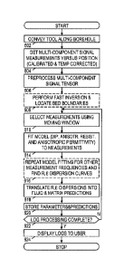
Fig. 6 is a flow diagram of an illustrative formation logging method. The
illustrated
method may be implemented by the systems illustrated in Figs. 1, 2, and 3E.
Alternatively,
systems such as those illustrated in Figs. 1, 2, and 3E may acquire the data
and communicate it
to a remote workstation where the remaining portion of the illustrative method
is carried out.
The logging method begins in block 602 with the conveyance of a multi-
component
induction logging tool along a borehole, e.g., as a wireline tool or a LWD
tool. In block 604, as
the tool is being conveyed along the borehole, it obtains multi-component
signal measurements
for each of the antenna arrays and signal frequencies as a function of the
tool's position in the
borehole. Tool calibration and temperature correction are normally applied
during or shortly
after the measurements are acquired. In at least some cases, the logging tool
assembly further
includes instruments to measure borehole diameter (dhok) and borehole fluid
resistivity Rhok.
In block 606, the system preprocesses the multi-component signal measurements
and
borehole size logs. Such preprocessing can include adaptive low-pass filtering
to remove high-
frequency measurement noise and/or to correct for horn-effect at formation
boundaries. In
some cases, the boundary horns may be removed or reduced using some combined
logs as
described in U.S. Pat. 6,819,112, titled "Method of combining vertical and
horizontal magnetic
dipole induction logs for reduced shoulder and borehole effects" by inventors
Gianzero and
Gao.
In optional block 608, the system tentatively locates bed boundaries. (Blocks
608 and
610 may be omitted for systems and methods using homogeneous "OD" model
inversion in
block 614.) Bed boundary detection can be performed in a number of ways,
including peak
detection to identify horn effects, signal processing to generate a boundary
crossing signal, or a
so-called "fast" inversion. Fast inversion employs a formation model having a
smaller
parameter space to trade off accuracy for speed. One illustrative model is the
"Radial 1D"
12
CA 02969322 2017-05-30
WO 2016/108909 PCT/US2014/073052
model, which assumes that the tool measurements are derived from a borehole
through an
otherwise homogeneous, infinite formation. Some embodiments of the model may
account for
eccentering of the tool and/or the presence of an invasion zone around the
borehole. Another
illustrative model is the "Vertical 1D" model, which assumes that the tool
measurements are
derived from a vertical borehole through a sequence of horizontal formation
beds each having
a corresponding (isotropic) resistivity. Such models yield a prediction of
relatively constant
resistivity within beds, the transitions between such regions of relatively
constant resistivity
then representing the locations of bed boundaries.
Given the number of parameters to be determined in the high-accuracy
inversion, it is
1.0 generally impractical to invert all of the measurements at once.
Consequently, a moving
window may be employed in optional block 610 to limit the measurements being
inverted to
those from the area around that region of the formation whose model parameters
are being
determined at that time. For subsequent regions of the formation, the moving
window is shifted
accordingly. The size of the window may be predetermined, either in terms of
the distance it
extends in each direction from the region, or in terms of the number of beds
it extends in each
direction from the current bed. The tentative bed boundaries from block 608
may be used for
this bed-based window size determination as well as for setting an initial
starting point of the
high-accuracy inversion.
In block 614, the system performs a high-accuracy inversion using an
anisotropic
formation model having parameters that include at least dip, horizontal and
vertical resistivity,
and horizontal and vertical permittivity. The high-accuracy inversion may
employ models that
are homogeneous ("OD"), that account for radial variation ("Radial 1D"), that
account for axial
variation ("Vertical 1D"), that account for radial and axial variation ("2D"),
or that account for
radial, axial, and azimuthal variation ("3D"). Consequently, other suitable
parameter values
determined by the inversion may include borehole fluid resistivity, borehole
diameter, invaded
region resistivity, invaded region diameter, tool eccentricity (distance and
direction), bed
boundary positions, and dip azimuth. The resistivity and permittivity may be
expressed in
various equivalent forms including, e.g., complex horizontal conductivity and
separate
anisotropy ratios that relate the real and imaginary portions of the complex
horizontal
conductivity to the corresponding portions of the complex vertical
conductivity. The
parameters vary with position, though bed-based models may presume that within
each bed the
parameter values are constant.
The inversion process adjusts these model parameters (as well as the tentative
bed
13
CA 02969322 2017-05-30
WO 2016/108909 PCT/US2014/073052
boundary locations in bed-based models) adaptively to find the parameter
values that minimize
a cost function. Representing the set of measurements cri,/ at a given
position p as nik(p), where
k is an index ranging from 1 to K to represent each combination of receive
antenna orientation
i, transmit antenna orientation j, spacing index value 1, and optionally each
frequency f, the cost
function can be expressed:
C(p)= I E =[,,,,,(õ_q)- ink (p ¨ q)1112
(8)
q--(2,+Q1c=1,K
where s k(p) is the measurement predicted by the model based on the current
model parameters,
and the weights wq provide a symmetric window of width 2Q+1 around the current
position p.
Suitable window shapes implementable by the weights include rectangular,
triangular,
Hamming, Hanning, and Blackman. It is noted here that the cost function (8) is
just an
example. Any other analytical function comparing predicted and actual
measurements can be
used. Cost function selection is typically done based on the topology of the
measurement space
and measurement error characteristics.
Again, the inversion process is the determination of those model parameters
that
minimize the cost function. This initial estimate of parameter values may be
based on the
optional fast inversion results from block 608.
In at least some preferred embodiments, the measurementsaiji being inverted in
block
614 correspond to a single signal frequency f, as experiments have indicated
that such a
measurement set would be sufficient for estimating the anisotropic
permittivity and resistivity
parameters of a formation. However, at least some contemplated embodiments
perform
simultaneous inversion of measurements at each of the multiple signal
frequencies employed
by the tool to determine dispersion curves of at least the anisotropic
resistivity and anisotropic
permittivity parameters. Where single-frequency inversion is performed in
block 614, optional
block 616 may be included to repeat the high-accuracy inversion for each
measurement
frequency, thereby sequentially determining a frequency dependence of the
anisotropic
permittivity and resistivity parameters. In either case, the system may fit a
model dispersion
curve to the frequency dependences or may determine which of multiple
candidate dispersion
curves best fits the frequency dependences of the anisotropic permittivity and
resistivity
parameters. The model or candidate curves may be based on a general dispersive
model such
as Cole-Cole or Cole-Davidson, or may be based on a model specific to
dielectric relaxation
losses.
In block 618, the system translates the dispersion curves and/or individual
anisotropic
14
CA 02969322 2017-05-30
WO 2016/108909 PCT/US2014/073052
permittivity and resistivity parameter values into predictions of the
characteristics of the
formation fluid and matrix. Such characteristics may include fluid saturation
(e.g., a volume or
percentage of water in the formation), rock ("matrix") type (e.g., sandstone,
shale), and
presence of materials having significant Maxwell-Wagner polarization (e.g.,
pyrite, clay).
Fluid saturation and porosity are characteristics that may be derived from
horizontal formation
resistivity. Rock type may be derived based on resistivity in combination with
resistive
anisotropy. The anisotropy ratio or index of permittivity indicates the
presence of pyrite and
other materials having anisotropic polarization.
In block 620, the system stores the inverted parameter values and the
associated
predictions, typically in the form of a parameter log. In block 622, the
system determines
whether all of the tool measurements have been processed, and if not, the
process returns to
block 610 to adjust the position of the window and repeat blocks 614-622. Once
processing is
complete, the system displays a visual representation of the logs to a user in
block 624. The
user may interpret the logs to determine completion and production strategies,
as well as to
optimize further drilling in the same or other nearby boreholes.
Embodiments disclosed herein include:
A: A logging method that comprises: obtaining multi-component signal
measurements
from an electromagnetic logging tool conveyed along a borehole through a
formation;
inverting the multi-component signal measurements for at least a single
frequency using an
anisotropic formation model having at least dip, horizontal and vertical
resistivity, and
horizontal and vertical permittivity, as inversion parameters; and providing a
log for said
formation, the log representing a position dependence of at least one of said
parameters or a
formation property derived from at least one of said parameters.
B: A logging system that comprises: an electromagnetic logging tool that
acquires
multi-component signal measurements as the tool is conveyed along a borehole
through a
formation; and a processing system that provides a log of the formation log by
inverting the
multi-component signal measurements for at least one frequency using an
anisotropic
formation model having at least dip, horizontal and vertical resistivity, and
horizontal and
vertical permittivity, as inversion parameters.
C: A nontransient information storage medium having software that, when
executed by
a processing system, causes the processing system to perform the method of
Embodiment A.
Each of the embodiments A, B, and C may have one or more of the following
additional elements in any combination: Element 1: providing the log includes
displaying the
CA 02969322 2017-05-30
WO 2016/108909 PCT/US2014/073052
log in visual form. Element 2: providing the log includes storing the log in a
non-transient
information storage medium for later analysis. Element 3: the log represents
an estimated
water saturation that is based at least in part on one or more of the
horizontal and vertical
resistivity, and horizontal and vertical permittivity. Element 4: the log
represents a rock type
based at least in part on one or more of the horizontal and vertical
resistivity, and horizontal
and vertical permittivity. Element 5: the log represents a rock type based at
least in part on a
ratio of the horizontal and vertical permittivity. Element 5: the multi-
component signal
measurements for a single frequency include measurements acquired with at
least two different
relative orientations between transmit and receive antennas. Element 6: the
method further
includes: using the anisotropic formation model to perform separate inversions
of multi-
component signal measurements at each additional frequency; and identifying a
dispersion
model that represents a frequency dependence of said parameters. Element 7:
the log
represents a rock type based at least in part on the representative dispersion
model. Element 8:
the electromagnetic logging tool is a logging-while-drilling tool. Element 9:
the
electromagnetic logging tool is a wireline tool. Element 10: the
electromagnetic logging tool
includes one or more tilted antennas for acquiring the multi-component signal
measurements.
Element 11: the measurements are acquired by at least one tilted receiver
antenna's response to
at least one tilted transmitter antenna.
Numerous other modifications, equivalents, and alternatives, will become
apparent to
those skilled in the art once the above disclosure is fully appreciated. It is
intended that the
following claims be interpreted to embrace all such modifications,
equivalents, and alternatives
where applicable.
16