Note: Descriptions are shown in the official language in which they were submitted.
SYSTEM FOR SENSING INTERIOR SPACES
TO AUTO-GENERATE A NAVIGATIONAL MAP
FIELD OF THE INVENTION
[0001] The present invention relates to mapping, more particularly it
relates to
methods and systems for sensing an interior space to automatically generate a
map to
facilitate navigation thereof.
DESCRIPTION OF THE RELATED ART
[0002] Mapping of interior spaces is gaining in popularity as there
is a need to
easily navigate large buildings, such as hospitals, government buildings,
malls,
convention centers, libraries, universities, stadiums, airports, and so forth.
Navigational
maps are often created manually using floor plan images, and these maps are
used with
portable devices to provide navigational tools which determine the user's
position
within a given space.
[0003] Some navigational tools are also able to provide turn-by-turn
indoor
navigation, however, such tools rely heavily on manual work to assemble the
requisite
map and directions, resulting in a cumbersome and time-consuming process.
Generally,
in order to provide turn-by-turn navigation, an interior positioning system
needs the
ability to locate a client device, such as a handheld device, within a space
and to map
that location to a representation of the space that embodies a true
understanding of its
physical characteristics, barriers, structures, such as walls, passageways
stairs etc. Any
such representation is considered to be a croutable' map of the floor plan, as
it embodies
the necessary information to plot a route through the space, in contrast to
simple image
of a floor plan. If the indoor positioning system has no knowledge of the
physical
characteristics, barriers, structures, then the onus is on the user to
understand the
markings on the map, and determine markings that represent physical barriers
or
structures. Therefore, the user is forced to self-navigate around those
barriers or
structures based on an understanding of his/her relative position on that map,
which can
be challenging for visually impaired individuals.
- 1 -
CA 2970940 2017-06-16
[0004] At present, there exists several approaches for providing
turn-by-turn
navigation in indoor spaces such as proximity-based, triangulation and/or
trilateration,
ambient signal fingerprinting, and motion based solutions. Proximity based
technologies, such as iBeaconTM, from Apple Inc., Cupertino, California,
U.S.A., and
radio-frequency identification (RFD)) provide turn-by-turn navigation by
detecting the
proximity and range of a handheld user device, such a smartphone, to beacons,
or RF1D
tags, deployed meticulously within a building to be navigated. Accordingly, in
order to
achieve the positioning accuracy required for turn-by-turn navigation within
typical
buildings, the deployment would necessitate a relatively high density of
beacons/tags,
which would be impractical and relatively expensive. In addition, proximity-
based
technologies are fundamentally unaware of the surrounding space, that is,
walls,
passageways or openings of a building, or other objects or obstacles.
[0005] Wi-Fi triangulation and/or trilateration are other popular
technologies for
enabling indoor navigation. Wi-Fi is a registered trademark of the Wi-Fi
Alliance.
These triangulation and/or trilateration techniques calculate a relative
position of a
receiver, such as a handheld user device, based on the signal strength of the
radio
signals from Wi-Fi routers installed in buildings. Similar to iBeacon, if the
specific
locations of the routers are known, and have been mapped against the space,
then a
client application on the user device can triangulate and/or trilaterate those
signals and
determine the user device's location relative to the routers. However, while
Wi-Fi
triangulation and/or trilateration can calculate the user device's position
with an
accuracy of within a few feet, this approach relies on existing
infrastructure, that is, by
leveraging Wi-Fi routers that already exist to support network access within a
building.
As such, since existing infrastructures are typically designed to provide
network
coverage of a building, there is usually only one access point (AP), while
position
triangulation and/or trilateration require access to at least three APs.
Therefore, most
areas of a building would lack sufficient coverage to support navigation, and
additional
deployment of routers would be required to enable navigation. Furthermore,
unpredictable signal reflection and attenuation inside buildings introduces
distance
- 2 -
CA 2970940 2017-06-16
measurement errors, thereby severely impacting the accuracy of the positioning
information, thus rendering turn-by-navigation directions non-reliable.
Additionally,
most companies or organizations are reluctant to increase network traffic and
latency on
their Wi-Fi networks, or allow access to Wi-Fi networks carrying sensitive
data.
[0006] With both iBeacon and RFID-based approaches, current
triangulation and/or
trilateration systems are dependent on the availability of a routable map of
the floor plan
to provide turn-by-turn directions. Such maps are generally created via a
manual
scanning or a mapping process performed by a user or a system installer, as
will be
described in greater detail below. This process may include walking the
perimeter of
every room and hallway of a building, or may involve onsite visits from a paid
consultant to scan and map the space. As such, each time the configuration or
layout of
the space changes, due to renovations or temporary closures, the
scanning/mapping
process must be repeated.
[0007] Yet another approach encompasses a variety of techniques
that employ
similar strategies to reliably identify unique locations within a space. These
strategies
typically leverage the availability of a wide variety of ambient signals that
are a natural
characteristic of, or artificially deployable into, indoor locations. The goal
is to employ
sensors that can recognize minute differences in environmental conditions
(natural or
artificial) as defined by these signals to create a baseline for these
conditions throughout
an interior space. This baseline creates a fingerprint for that signal that is
uniquely
associated with a location within the space. For example, one approach
recognizes that
electromagnetic signatures are influenced by building structure and contents,
and are
actually unique to specific areas within an indoor space. Analyzing and
recognizing
these signatures provides a means of positioning. Similarly, air pressure
changes can be
leveraged as a measure of altitude and used to distinguish between floors of
multi-story
buildings. In addition to naturally ambient signals, the indoor space may be
artificially
instrumented with additional signals. The most common of such signals would be
the
Wi-Fi radio signals produced by network routers. By sampling the signal
conditions
over time, a signal fingerprint can be established that is characteristic of
the specific
-3 -
CA 2970940 2017-06-16
location in which the sample is taken. When the fingerprint is recognized,
location can
be assumed. However, other artificial signals can be deployed, such as non-
visible light
pulses or ultra/sub-sonic sounds, that can be used to create unique
fingerprints for
specific locations within an indoor space. These artificial signals can be
defined to
indicate specific areas of an indoor space, as is the case with existing
implementations
that employ non-visible light pulses from LED lighting, or create location
specific
fingerprints similar to what was described above, as is the case with existing
implementations that employ ultra/subsonic sound. Again, as with both
proximity-based
and triangulation and/or trilateration technologies, signal fingerprinting
based systems
require routable maps of the floor plan, which must be created using one of
the
approaches described below.
[0008] Yet another approach encompasses strategies for calculating
changes in
position from a known position by tracking localized motion of the user within
the
space. Information about the motion of the user can be used to infer changes
in position.
For example, the accelerometer in a smartphone can report changes in
acceleration, both
direction and force, which can be used to infer the magnitude of a change in
position.
Similarly, image based approaches use smartphone cameras and image processing
to
infer changes in direction by calculating the relative changes in pixels in
the image.
Again, as with all other technologies mentioned, motion based approaches
require
routable maps of the floor plan, which must be created using one of the
approaches
described below.
[0009] Routable maps of indoor spaces may be based on site walks,
manual image
tracing, image recognition and crowdsourcing. Site walks are a common approach
to
mapping indoor spaces for the purposes of creating routable' maps to enable
turn-by-
turn navigation. Site walks involve considerable manual effort, requiring a
user (or paid
consultant) to physically walk the entire indoor space while holding a purpose-
built
device (or smartphone and app) in order to define every walkable space in the
building,
such as each room and hallway, as well as in aisles in larger, open spaces.
The device
records the position of the user performing the site walk using the indoor
positioning
- 4 -
CA 2970940 2017-06-16
system (IPS) technology being installed in the space (see above) in order to
map out the
physical characteristics of the building. Once the spaces have been mapped, a
manual
process of identifying the spaces (i.e. name the retailers, identify
bathrooms, etc.) must
be manually performed.
[0010] Another common approach to creating `routable' maps, notably
used by
Google Indoor Maps amongst others, is manual mapping. The process involves the
annotation of an existing non-routable map (an image of the floor plan). The
annotations define the walls, passageways, staircases and any other relevant
details of
the space in order to create a routable version of the map. The annotation is
a manual
process - an employee of the service provider or the customer themselves,
manually
analyses the map and manually inputs the required information. As such, this
process
can be time consuming and error prone. Once the routable map is created, it is
aligned
with the positioning information available from whichever positioning
technology is
being deployed in the space.
[0011] Yet another approach to enable turn-by-turn navigation is
based on image
recognition. One solution requires the availability of an image of a floor
plan for a
space (a non-routable map), and the image is uploaded to a service provider,
where
complex image processing algorithms are applied. These algorithms attempt to
identify
specific physical characteristics described on the floor plan, such open
spaces, rooms,
hallways, elevators, stairways etc. The goal of this analysis is to create
spatial
connectivity graphs that can be used to identify routes through the map for
the purpose
of enabling turn-by-turn navigation. As with other approaches, once the
routable map is
created through this process, it must be aligned with the positioning
information
available from whichever positioning technology is being deployed in the
space.
[0012] Another solution is based on image recognition, and involves
analysis of
photographs of the interior of the space to be mapped. A process of recording
photographs of every physically relevant element (e.g. walls, doorways, etc.)
within the
space is undertaken. Image recognition algorithms are employed to identify co-
located
imagery (i.e. photos of adjacent walls) as well as infer relative sizing. This
information
- 5 -
CA 2970940 2017-06-16
is used to piece together a composite map of the floor plan. However, this
process
involves significant post processing human involvement for purposes of
correction and
adjustment. Again, as with other technologies, once the routable map is
created through
this process, it must be aligned with the positioning information available
from
whichever positioning technology is being deployed in the space.
[0013] Yet another approach employs crowdsourcing to define a space,
in which
images of interior spaces are collected, analyzed and assembled into a
cohesive map.
Another approach relies on the common movements of users of the space, and
tracks
those movements using whichever positioning technology is being deployed in
the
space. Over time, the common movements define patterns of movement within the
space, which can be inferred to define relevant spatial connectivity and
identify
navigable routes through the space for the purpose of enabling turn-by-turn
navigation.
The above-noted approaches result in maps that are a snapshot of the floor
plan, and
therefore each instance there is a change to the floor plan or space, the
mapping process
must be performed in order to capture the changes and update the map
accordingly.
[0014] It is an object of the present invention to mitigate or
obviate at least one of
the above-mentioned disadvantages.
SUMMARY OF THE INVENTION
[0015] In one of its aspects, there is provided a transponder for
sensing a spatial
environment for the purposes of creating a local map model of said spatial
environment,
said transponder comprising:
a microprocessor;
at least one sensor for scanning said spatial environment and acquiring
sensing information about said spatial environment;
a memory having instructions executable by said microprocessor to
cause the microprocessor to process said sensing information to:
determine distance measurements between said transponder and
features within said spatial environment; and
generate said local map model;
- 6 -
CA 2970940 2017-06-16
a communications interface module coupled to said microprocessor for
enabling communication with a first computing device to send said local map
model thereto and for enabling communication with a second computing device
for using said local map model to navigate said spatial environment.
100161 In
another of its aspects, there is provided, in a spatial environment, a
method for determining a relative position of at least one transponder, the
method
comprising the steps of.
positioning a first transponder in a first location within said spatial
environment;
positioning a second transponder in a second location within said spatial
environment;
positioning a third transponder in a third location within said spatial
environment,
wherein each of said transponders comprises at least one sensor;
causing each of said first transponder, said second transponder, and said
third
transponder to scan said spatial environment and with said at least one sensor
to
measure distances within said spatial environment relative to each of said
locations and
determine orientation of said transponder within said spatial environment and
each of
said first transponder, said second transponder, and said third transponder
composing a
corresponding first local map model, second local map model and a third local
map
model of said spatial environment;
each of said first transponder, said second transponder, and said third
transponder transmitting said first local map model, second local map model
and a third
local map model of said spatial environment to said first computing device;
at said first computing device, overlaying and aligning said first local map
model, second local map model and a third local map model of said spatial
environment
to form a composite map model of said spatial environment; and
calculating said relative position of each of said first transponder, said
second
transponder, and said third transponder based on distance measurements from
each of
said transponders.
- 7 -
CA 2970940 2017-06-16
[0017] In
another of its aspects, there is provided, in a spatial environment, in a
spatial environment, a method for determining a relative position of at least
one
transponder of a set of transponders positioned in different locations within
a spatial
environment, the method comprising the steps of:
positioning a first transponder in a first location; positioning a second
transponder in a second location; positioning a third transponder in a third
location,
wherein each of said transponders comprises at least one sensor;
causing said first transponder to scan said spatial environment and with said
at
least one sensor to measure distances within said spatial environment relative
to said
first location and composing a corresponding first local map model; causing
said second
transponder to scan said spatial environment and with said at least one sensor
to
measure distances within said spatial environment relative to said second
location and
composing a corresponding second local map model; causing said third
transponder to
scan said spatial environment and with said at least one sensor to measure
distances
within said spatial environment relative to said third location and composing
a
corresponding third local map model; and wherein at least two of said
transponders scan
at least one common feature, and
each of said first transponder, said second transponder, and said third
transponder transmitting said first local map model, second local map model
and a third
local map model to said first computing device;
at said first computing device,
overlaying a first pair of said first local map model and said second local
map model in different positions and orientations to iteratively match common
features
between said first pair, and determining a best match between said first local
map model
and said second local map model according to a predetermined match criteria;
and when
said best match is determined, generating a first composite map model
comprising said
first local map model and said second local map model; and
overlaying a second pair of said first local map model and said third
local map model in different positions and orientations to iteratively match
said at least
- 8 -
CA 2970940 2017-06-16
one common feature between said second pair, and determining a best match
between
said first local map model and said third local map model according to a
predetermined
match criteria; and when said best match is determined, generating a second
composite
map model comprising said first local map model and said third local map
model; and
overlaying a third pair of said second local map model and said third
local map model in different positions and orientations to iteratively match
said at least
one common feature between said third pair, and determining a best match
between said
second local map model and said third local map model according to a
predetermined
match criteria; and when said best match is determined, generating a third
composite
map model comprising said first local map model and said third local map
model;
generating a single composite map model comprising said first
composite map model, said second composite map model and third composite map
model; and
calculating said relative position of each of said first transponder, said
second
transponder, and said third transponder based on distance measurements from
each of
said transponders.
[0018] In another of its aspects, there is provided a method for
generating a routable
map of a spatial environment, the method comprising the steps of:
positioning a transponder in a location within said spatial environment;
associating at least one sensor with said transponder, said at least one
sensor
being rotatable in at least one plane;
measuring distances within said spatial environment with said at least one
sensor relative to said location; and
composing a local map model of spatial environment based on said
measurements.
[0019] In another of its aspects, there is provided a wayfinding
system comprising:
a first device comprising at least one sensor for sensing a spatial
environment to
generate a first map, said a first device positioned in a first position in
said spatial
environment;
- 9 -
CA 2970940 2017-06-16
a second device for receiving signals from said first device to determine a
relative position of said second device within said spatial environment; and
wherein on said second device said relative position is used in conjunction
with
said first map to provide turn-by-turn navigation within said spatial
environment.
[0020] Advantageously, the mapping procedure and routable map
generation is
dynamic and automated, resulting in substantially less manual work, which
results in
easier and faster deployment than current methods. The system is capable of
detecting
any changes made to any part of the floor plan, space, or device deployment,
and such
changes are registered for seamless, automatic updates of the floor plan and
routable
map, without any user intervention. The system is capable of real-time
mapping, as the
transponders can automatically respond to changes in their location due to
renovations,
temporary deployments of objects or structures, or relocations. For example,
floor plans
for dynamically configured interior spaces such as retail stores can be easily
kept up-to-
date.
[0021] Additionally, by integrating the mapping sensors and the
radios used to
provide location information into the same physical device, the transponder
automatically solves a problem that all other systems must rely on manual
intervention
to address. In other systems, in order to accurately triangulate/ trilaterate
a position on a
map based on radio signals, the exact location of the source of those signals
must be
known. Prior art indoor location systems that do not have an innate
relationship between
the maps and signal sources must establish and maintain this relationship
manually, and
such prior art systems are more susceptible to inaccuracy due to errors in the
assumed
location of the signal sources relative to the map. In contrast, with this
system the exact
location of the radio signal sources i.e. the transponders can be determined,
even if the
transponders are moved to new locations within the space, because the source
of the
signal can be co-located with the transponder's spatial sensors. Each
transponder is
aware of its own position relative to the surrounding physical structures on
the maps
they create, since the maps are created based on the measurements made by
spatial
sensor to the surrounding physical structures.
- 10 -
CA 2970940 2017-06-16
BRIEF DESCRIPTION OF THE DRAWINGS
[0022] Several exemplary embodiments of the present invention will
now be
described, by way of example only, with reference to the appended drawings in
which:
[0023] Figure I is a top-level component architecture diagram of an
exemplary
mapping system;
[0024] Figure 2a shows a schematic diagram of a transponder;
[0025] Figure 2b shows an exploded view of a transponder;
[0026] Figure 2c shows a perspective view of the transponder;
[0027] Figure 2d shows a top view of the transponder;
[0028] Figure 2e shows a sectional view of the transponder of
Figure 2c along line
A-A;
[0029] Figure 3 shows a high level flow diagram illustrating an
exemplary process
steps for sensing and mapping a spatial environment;
[0030] Figures 4a, 4b, 4c and 4d show a local map model generated
by individual
transponders;
[0031] Figure 5 shows a floor plan with transponder locations;
[0032] Figures 6a, 6b, 6c show locations of individual transponders
positioned in an
exemplary spatial environment;
[0033] Figure 6d shows a resulting map with the relative location
of each
transponder;
[0034] Figure 6e shows a triangulation and/or trilateration method
for determining a
relative location of a transponder added to the exemplary spatial environment;
[0035] Figure 7 shows a high level flow diagram illustrating an
exemplary process
steps for creating a routable map, in another embodiment;
[0036] Figure 8 shows a high level flow diagram illustrating an
exemplary process
steps for creating a routable map, in yet another embodiment;
[0037] Figure 9a shows the location of transponders in a spatial
environment;
[0038] Figures 9b to 9d show local map model corresponding to the
transponders of
Figure 9a;
- 11 -
CA 2970940 2017-06-16
[0039] Figures 10a to 10d show the pairing of the local map models
to determine
the best match to generate a working composite map model; and
[0040] Figures 1 1 a to lld show the pairing of a local map model
with the working
composite map model to generate a final composite map model.
DETAILED DESCRIPTION OF EXEMPLARY EMBODIMENTS
[0041] The detailed description of exemplary embodiments of the
invention herein
makes reference to the accompanying block diagrams and schematic diagrams,
which
show the exemplary embodiment by way of illustration and its best mode. While
these
exemplary embodiments are described in sufficient detail to enable those
skilled in the
art to practice the invention, it should be understood that other embodiments
may be
realized and that logical and mechanical changes may be made without departing
from
the spirit and scope of the invention. Thus, the detailed description herein
is presented
for purposes of illustration only and not of limitation. For example, the
steps recited in
any of the method or process descriptions may be executed in any order and are
not
limited to the order presented.
[0042] Moreover, it should be appreciated that the particular
implementations
shown and described herein are illustrative of the invention and its best mode
and are
not intended to otherwise limit the scope of the present invention in any way.
Indeed,
for the sake of brevity, certain sub-components of the individual operating
components,
conventional data networking, application development and other functional
aspects of
the systems may not be described in detail herein. Furthermore, the connecting
lines
shown in the various figures contained herein are intended to represent
exemplary
functional relationships and/or physical couplings between the various
elements. It
should be noted that many alternative or additional functional relationships
or physical
connections may be present in a practical system.
[0043] Figure 1 shows a top-level component architecture diagram of
an exemplary
system, generally identified by reference numeral 10, for enabling turn-by-
turn
navigation in a spatial environment. System 10 generally includes a plurality
of
transponders 12 positioned at different locations within the spatial
environment, such as
- 12 -
CA 2970940 2017-06-16
a room or building. Each transponder 12 is configured to sense its environs by
measuring relative distances to objects and/or structures in order to generate
a local map
model, as will be described in more detail below.
[0044] The
generated local map model is transmitted to a computing system 14 of a
central management unit 16 via communications network 18, such as the
Internet,
and/or any other suitable network. Examples of computing system 14 may
include, but
are not limited to: a personal computer, a server computer, a series of server
computers,
a mini computer, and a mainframe computer. For example, server computer 14
comprises one or more databases 20, which may be any type of data repository
or
combination of data repositories, which store records or other representations
of data.
Accordingly, generated maps are stored on databases 20 and accessible to user
devices
22 via server computer 14.
[0045] Now
turning to Figure 2a, there is shown a schematic diagram of an
exemplary transponder 12, comprising processing and control module 30 having
processing circuitry, such as, microprocessor 32, which is arranged to
communicate, via
system bus 34, with memory 36 and sensing module 37. The skilled person will
appreciate that memory 36 may be provided by a variety of components including
a
volatile memory, a hard drive, a non-volatile memory, etc. Indeed, memory 36
comprise
a plurality of components under the control of the, or otherwise connected to,
the
processor 32. However, typically memory 36 provides a program storage portion
arranged to store program code which when executed performs an action, such as
pattern recognition engine 38, map modeller 39, and a data storage portion 40
which
can be used to store data either temporarily and/or permanently. Sensing
module 37
receives sensory input signals from a sensor, a plurality of sensors, or
sensor array 41,
which are converted to sensory data via signal processing means and stored in
data
storage portion 40 accessible to processing and control module 30. Generally,
sensors
41 scan the physical space surrounding each individual transponder 12 by
measuring
distances, and pattern recognition engine 38 comprises executable instructions
that
perform a pattern recognition process to recognize common physical attributes
within
- 13 -
CA 2970940 2017-06-16
said spatial environment, such as objects and physical landmarks, such as,
walls,
doorways, etc.
[0046] Transponder 12 also includes communications interface module
42 with a
transceiver for emitting radio signals to user device 22 and other
transponders 12 to
determine a relative position of user device 22 in the spatial environment,
and for
receiving radio signals from other transponders 12, as will be described in
more detail
below. Communications interface module 42 may include a wired interface,
wireless
interface, optical, IR interface or RF interface, and may use standard
protocols such as
SONET, SDH, Zigbee, Ethernet, Wi-Fi (e.g. IEEE 802.11a/b/g/n, WiMax),
Bluetooth,
powerline communication (e.g. IEEE 1901), or other standard and non-standard
physical layers well known to those skilled in the art. Antenna 43 is
electrically
connected to the transceiver. In addition, communications interface module 42
enables
connection to shared or remote drives, one or more networked computers 14, or
other
networked devices, via communications network 18 Communications interface
module
42 also allows transponder 12 to be monitored by server computer 14 for
maintenance
purposes. Accordingly, each transponder 12 includes a unique identifier, such
as a
media access control (MAC) address, which is discovered or registered with
server
computer 14.
[0047] Sensors 41 are mounted on a movable platform which allows
sensors 41 to
be positioned and repositioned to capture distance information relative to the
transponder 12 in a spatial environment having other objects or structures.
The base
includes motors controlled by a motor drive module 44, which receives control
commands from processing and control module 30. Sensors 41 may operate based
on a
sensing technology, such as, sonar, laser, IR, radar and lidar, radio
frequency (RF) or a
combination thereof, to measure distances. Any other sensing technology
capable of
measuring discrete distances may be suitable, and different sensing
technologies may be
employed as appropriate to suit particular situations and use cases, and the
choice may
depend on the cost of the transponder, room size, accuracy requirements, and
so forth.
For example, laser and infrared sensors determine distance on the basis of
time of flight
- 14 -
CA 2970940 2017-06-16
of light, while lidar measures distance by measuring the minute time
differences
between the transmission and reception of single-band laser signals that are
beamed at
an object. These signals are then digitally processed and analyzed to produce
time delay
data that is used to calculate the distance and generate a local map model of
the sensed
environment.
[0048] In one exemplary embodiment, each transponder 12 is deployed
into
existing spaces without the need for additional electrical or data
connections, and
without any imposition in existing network infrastructure. Typically,
transponder 12 is
powered via existing AC mains, and may be connected to a standard AC wall
socket,
standard light socket, or emergency lighting installation.
[0049] As shown in Figures 2b, 2c, 2d and 2e, transponder 12
comprises base 50 to
be attached to a ceiling, a wall or the like, and a chassis or platform 51
rotatably
attached to base 50 having a pan bevel gear 52 associated therewith. Sensors
41 are
mounted on a sensor cradle 53 rotatably mountable on platform 51, and secured
to
sensor cradle 53 is tilt bevel gear 54. Also mounted on platform 51 is tilt
motor 55
which turns tilt motor bevel gear 56 with teeth that interlock with teeth of
tilt bevel gear
54 to rotate sensor cradle 53 and sensors 41 through a range of motion.
Platform 51 is
panned through a range of motion by pan motor 57 which turns pan motor bevel
gear 58
with teeth that interlock with teeth of pan bevel gear 52. Motor drive module
44 allows
pan and tilt motors 55 and 57 to preferably employ low cost stepper motors.
Motor
drive module 44 performs linearization of the motor drive signals so that
small micro-
steps can be made. The linearized micro-steps provide a smooth panning or
tilting of
platform 51, and hence sensors 41, at slow speeds and in both elevations and
azimuth
directions The linearization requires different commands for moving in one
direction
than the other. Printed circuit board 59 including processing and control
module 30,
memory 36, sensing module 37, motor drive module 44, bus 34 and communication
interface module 42 is housed inside base 50. Antenna 43 is coupled to
communication
interface module 42 on printed circuit board 59. Cover 60 is secured to
platform 51 to
enclose the various components of transponder 12.
- 15 -
CA 2970940 2017-06-16
[0050] User device 22 may be in the form of any kind of general
processing
structure, and may for example include any device, such as, a personal
computer,
laptop, computer server, handheld user device (e.g. personal digital assistant
(PDA),
mobile phone, tablet, smartphone).
[0051] Referring now to Figure 3, there is shown a high level flow
diagram
illustrating exemplary process steps for generating a composite map
corresponding to a
chosen spatial environment. In step 200, a set of transponders 61a, 61b, 61c,
61d are
positioned in known locations within a spatial environment, such as a building
floor
with a plurality of rooms, as shown in Figure 4. For example, transponder 61a
senses
space 62 by rotating the movable platform 51 3600 in a single plane or in
multiple
translational planes (x, y, z) to determine relative distances. Accordingly,
at each degree
(or fraction thereof) of rotation around each plane, a distance measurement is
recorded.
In step 202, sensors 41 of transponder 61a yield a range sensor data set, and
using
instructions of map modeller 39 executable by processing and control module
30, a 3D
local map model corresponding to a portion of space 62 in the field of view of
sensors
41 is generated. Figure 4a shows a 2D local map model 63 comprising grid
points
computed from the measurements which define walls 64, 66 and 68, and openings
70,
71, A 3D local map model is also generated based on other spatial or elevation
measurements. The modelling process may be a client-side process stored on one
or
more storage devices coupled to one or more transponder. In such an
implementation,
processing and control module 30 may include a stand-alone application or an
appl et/application that is executed within a client application.
[0052] Similarly, sensors 41 of transponder 61b yield a range
sensor data set and
using instructions of map modeller 39 executable by processing and control
module 30,
a 3D local map model corresponding to a portion of space 62 in the field of
view of
sensors 41 is generated. Figure 4b shows a 2D local map model 72 comprising
grid
points computed from the measurements which define walls 74, 76 and 78, and
opening
80. Sensors 41 of transponder 61c yield a range sensor data set, and using
instructions
of map modeller 39 executable by processing and control module 30, a 3D local
map
- 16 -
CA 2970940 2017-06-16
model corresponding to space 82 in the field of view of sensors 41 is
generated. Figure
4c shows a 2D local map model 84 comprising grid points computed from the
measurements which define walls 86, 88, 89 and 90, openings 92, 94 and window
96.
Sensors 41 of transponder 61d yield a range sensor data set, and using
instructions of
map modeller 39 executable by processing and control module 30, a 3D local map
model corresponding to space 98 in the field of view of sensors 41 is
generated. Figure
4d shows a 2D local map model 100 comprising grid points computed from the
measurements which define walls 102, 104, 106, and 108, opening 110, and
window
112.
[0053] In the next step 204, each transponder 61a, 61b, 61c or 61d
communicates its
local map model 63, 72, 84, or 100 corresponding to its surrounding physical
space 62,
82 or 98, respectively, to server computer 14. In addition to the model
details,
information including but not limited to: physical location in the spatial
environment
relative to all other transponders, compass orientation and altitude (based on
altimeter
measurements), is also provided to the server computer 14.
[0054] Once all of the data is collected at the central management
unit 16, a
navigation solution can be formed, which may include but is not limited to:
two-
dimensional position, three-dimensional position, position relative to known
landmarks
or map features, heading, orientations, speed, bearing, and the like. A server
application
executes program instructions to build a composite map of the entire space in
which the
system is deployed, using the determined relative positions, orientations and
altitude, in
step 206. The server application positions each local map model 63, 72, 84,
100 on a
grid formed of a plurality of grid cells having individual coordinates. Next,
each model
63, 72, 84, 100 is oriented correctly on the grid, based on the known
locations of the
transponders 61a, 61b, 61c and 61d, and the compass orientation indicated in
the local
map model 63, 72, 84, or 100. Models that are indicated to be at different
altitudes are
positioned onto separate grids, and are presumed to represent different levels
of the
same building. Figure 5 shows an exemplary building floor plan 114 derived
from local
map models 63, 72, 84, and 100, in which common features, such as structures,
objects,
- 17 -
CA 2970940 2017-06-16
walls, openings, passageways, doorways, furniture etc. are recognized using
pattern
recognition algorithms and registered to avoid duplication of such features on
the
eventual composite floor plan 114. Accordingly, a pattern recognition module
38
having executable instructions to perform a pattern recognition process to
recognize
common physical attributes within said spatial environment.
[0055] As can be seen in Figure 5, transponder 61a is positioned at
physical location
(2,3) within space 62, transponder 61b is positioned at physical location
(2,9) within
space 62, transponder 61c positioned at physical location (8,3) within space
82, and
transponder 61d positioned at physical location (8,9) within space 98.
[0056] System 10 therefore minimizes the deployment effort, as it
eliminates the
need for manual site surveys, or complex transcription of map/floor plan
images into
routable formats. System 10 also facilitates self-healing of map models, as
the
transponders 61a, 61b, 61c and 61d constantly, or periodically monitor their
spaces 62,
82 and 98 to detect any changes therewithin, and generate and upload the
updated local
map models to the server computer 14. Therefore, the composite map model is
automatically updated to maintain the most up-to-date map, and any lag time
between
physical changes in a space and the updates to the digital representation of
the physical
space is substantially reduced. In addition, automated composition of routable
floor
plans of the space in which the system is installed is therefore facilitated.
Each
transponder 61a, 61b, 61c or 61d emits radio signals that can be interpreted
by user
device 22 to determine the relative position of user device 22 within the
space. This
positional data, in combination with the understanding of the floor plan, is
used to
determine turn-by-turn navigation directions to the user of the user device
22, including
searching for directions.
[0057] In another implementation, system 10 supports self-location
of a transponder
within a spatial environment. For example, once at least three transponders
are
powered on and setup, every subsequent transponder that is added to system 10
triangulates and/ or trilaterates the signals from at least three other
transponders to
establish its relative physical position. Accordingly, each transponder
comprises an
- 18 -
CA 2970940 2017-06-16
integrated transceiver having a full radio receiver client application capable
of
triangulating and/or trilaterating the signal information broadcast by other
transponders
in the system 10 for the purpose of self-locating. In order to triangulate
and/or trilaterate
location based on the strength of radio signals broadcast by a set of
transponders, the
relative position of each of the first three transponders in the system 10 is
established.
Figures 6a, 6b and 6c show three transponders 300, 302, 304, similar or
identical to
transponders 12, 61a, 61b, 61c and 61d, positioned at locations within a
spatial
environment, such as a room 310 with a pair of opposing wall structures 312,
312' and
314, 314'. Advantageously, by supporting self-location of individual
transponders 300,
302, 304, the need to manually establish the location of each transponder 300,
302, 304
for the purpose of enabling triangulation and/or trilateration of the radio
signals by user
devices 22 is substantially minimized.
[0058] Figure 7 shows a high level flow diagram illustrating
exemplary process
steps for determining the relative position of the first three transponders
300, 302, 304
in a spatial environment 310. In step 400, all three transponders 300, 302,
304 are
positioned in the same room 310, such that each transponder 300, 302, 304 can
map the
entire space of the room 310 individually, using the 3D spatial sensing method
steps
described above. Therefore, each transponder 300, 302, 304 scans the room 310
and
establish a local map of the surrounding walls (as described above). This map
essentially contains multiple distance measurements from the transponder 300,
302 or
304 to the walls for an entire 360 degree rotation. As shown in Figures 6a, 6b
and 6c,
each transponder 300, 302 or 304 is positioned in different areas of the room
310 and
measures different distances to the same wall in the room 310, step 402.
Figures 6a, 6b
and 6c illustrate local map information for each transponder 300, 302 or 304,
along with
orientation information and the arrows indicating exemplary distances to each
wall as
measured by the transponder 300, 302 or 304.
[0059] Next, each transponder 300, 302 or 304 sends its local map of
the room,
including orientation information from an integrated compass, to server
computer 14,
step 404, The server computer 14 uses the orientation information from each
- 19 -
CA 2970940 2017-06-16
transponder 300, 302 or 304 to align the maps correctly and overlays them
directly on
top of each other to create a composite map of the same room 310 from the
perspective
of each transponder 300, 302 or 304, step 406. Figure 6d shows the resulting
map with
the relative location of each transponder 300, 302, or 304 to each other. The
relative
location of the transponders 300, 302, 304 is subsequently computed based on
the
distance information contained in the map for each transponder 300, 302, 304
to the
walls in the room 310, step 408. Once the relative position of the first three
transponders 300, 302, 304 has been established, then traditional
triangulation and/or
trilateration techniques can be applied to establish the relative position of
an additional
transponder 306, step 410. In one example, this step comprises the steps of
measuring
the Wi-Fi signal strength from each of the existing transponders 300, 302, 304
to
determine a distance measurement. The three measurements establish an absolute
position for the newly added transponder 306 relative to the first three
transponders 300,
302, 304.
[0060] In
another implementation, the relative positioning of the first three
transponders can be determined when they are positioned in a room such the
areas that
the transponders scan overlap substantially. Accordingly, a sufficient subset
of the
walls or interior features that each transponder can detect in the room
overlaps with one
or more of the other transponders. This overlap can then be used to identify
common
features between the individual scans and used as a basis to assemble the
separate scans
into a single map. The process of identifying matching overlaps is similar in
concept to
assembling a jigsaw puzzle, and will be referenced in subsequent paragraphs as
'the
jigsaw approach' and further described below in the context of composite map
generation. Essentially, each scan is positioned in all possible combinations
against
every other scan until matches in scanned features are found. Each possible
match is
given a weighting based in the quality of the match, and the highest scoring
match is
used. A complete map of the room is composed by matching each individual local
map
model with all other local map models. Then, based on the distance information
- 20 -
CA 2970940 2017-06-16
contained in the map for each transponder to the walls in the room, the
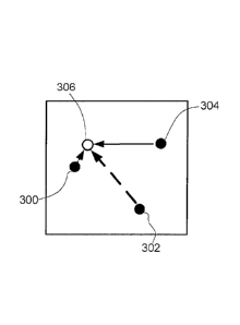
relative location
of the transponders can be calculated.
[0061] Once the relative position of the first three transponders
to each other has
been established, a combination of the grid approach and jigsaw approach may
be
combined to establish the relative positions of all subsequent transponders.
If the
subsequent transponder is positioned such that its scan has overlap with
previously
positioned transponders, then the same approach as described above (jigsaw
puzzle) for
positioning the first three transponders can be used to establish its relative
position.
[0062] If the subsequent transponder is not positioned such that
its scan has overlap
with previously positioned transponders, then triangulation techniques can be
applied to
establish the a general relative position of additional transponders that get
added to the
system to the three initial transponders. This is done by measuring the Wi-Fi
signal
strength from each of the existing transponders to determine a distance. The
three
measurements establish an absolute position for the newly added transponder
relative to
the first three transponders. However, due to inherent imprecision with using
traditional
triangulation techniques, triangulation alone is not sufficient. Therefore,
triangulation is
employed in conjunction with the jigsaw approach as described above in order
to refine
accuracy of the established position. Once the position of sufficient numbers
of
transponders have been generally established using the triangulation approach,
some
will inevitably have required overlap of their scan with the scan of
transponders whose
positions have been precisely determined using the 'jigsaw' approach. It is
then possible
to use the jigsaw approach again to refine the triangulated positions of the
transponders.
[0063] Figure 8 shows a high level flow diagram illustrating
exemplary process
steps for determining the relative position of the first three transponders
400, 402 and
404 in spatial environment 410, such as a room. As shown in Figure 9a, room
410 is
defined by walls 500, 502, 504, 506, 508, 510, 512, and 514 In step 500, all
three
transponders 400, 402 and 404 are positioned in spaced apart locations within
spatial
environment 410, such that the areas mapped by each transponder 400, 402 or
404
overlap substantially, as shown in Figure 9a. Therefore, each transponder 400,
402 and
-21 -
CA 2970940 2017-06-16
404 scans the spatial environment 410, and establishes a local map of the
surrounding
walls (as described above) (step 502). However, unlike in the previous
example, none
of these maps contain any additional information regarding relative position,
orientation
or altitude. Figure 9b shows a first local map 420 corresponding to the view
of the room
410 from the perspective of transponder 402, and comprises walls 500, 502,
504, 506,
510a, 512, and 514. Figure 9c shows a second local map 422 corresponding to
the view
of the room 410 from the perspective of transponder 404, and comprises walls
500a,
502, 504a, 508, 510, and 512. Figure 9d shows a third local map 424
corresponding to
the view of the room 410 from the perspective of transponder 400, and
comprises walls
500, 502, 504, 506, 508, 510b, and 514.
[0064] Next,
in order to create a complete floor plan, each transponder 400, 402 or
404 sends its respective local map 420, 422, and 424 of the spatial
environment 410 to
server computer 14, in step 504. For each local map model 420, 422, or 424,
every
other model 420, 422, or 424 is positioned against it in every position and
orientation
that results in some overlap of identified features so as to compare the
quality of the
match of those features in the local model 420, 422, and 424 and rate `similar-
ness'(step
506). The quality of a match can be assessed in a variety of ways, not limited
to: the
number of distinct line segments that overlap; the number of corners that
overlap; the
number of gaps between line segments that overlap; the position and
orientation pair
that result in the best match for all possible local map model pairing is
considered to be
the correct relative placement of the two specific local map models. For
example,
looking at Figure 10a, a pair of local map models 420 and 424 are compared in
one
orientation and are found to share only one common feature i.e. wall 502, and
no
common corners are shared. Meanwhile, in another orientation it is determined
that
models 420 and 424 share one common feature i.e. wall 500, and no common
corners
are shared, as shown in Figure 10b. In yet another orientation it is
determined that
models 420 and 424 share two common features i.e. walls 500 and 514, and 1
common
corner, as shown in Figure 10c. In even yet another orientation it is
determined that
models 420 and 424 share 5 common features i.e. walls 500, 502, 504, 506, and
514,
- 22 -
CA 2970940 2017-06-16
and 5 common corners, as shown in Figure 10d, thus representing the best match-
pair.
Therefore, once the two local map models 420 and 422 have been paired, they
are
combined and treated as a working composite local map model 426 to be used in
future
pairs (step 508).
[0065] In next step 508, working composite local map model 426 and
local map
model 422 are compared in one orientation and are found to share only 3 common
features i.e. wall 500 and 514, and no common corners are shared, as shown in
Figure
1 la. Meanwhile, in another orientation it is determined that models 422 and
426 share
one common feature i.e. wall 502, and no common corners are shared, as shown
in
Figure 11b. In yet another orientation it is determined that models 422 and
426 share
one common feature i.e. wall 500, and no common corners, as shown in Figure
11c. In
even yet another orientation it is determined that models 422 and 426 share 7
common
features i.e. walls 500, 502, 504, 506, 508, 510 and 514, and 4 common
corners, as
shown in Figure 11d, thus representing the best match-pair. Therefore, once
the models
422 and 426 have been paired, they are combined and treated as the final
composite
local map model 430 (step 510).
[0066] To better illustrate the positioning and orientation
approach, consider a
simplified characterization of relative positioning of two local map models in
terms of
the hour on a clock relative to the centre of the clock face, in which a local
map model
positioned at 12 o'clock is positioned directly above another, while one
positioned at 2
o'clock is positioned slightly above and to the right of another.
[0067] Similarly, consider a simplified characterization of
orientation of a single
local map model in terms of the points on a compass. A map oriented in due
North
orientation is 180 degrees rotated from one oriented in due South orientation,
Finally,
consider 2 local map models A and A' for comparison with each other using the
jigsaw
approach. Suppose that model A be positioned statically (i.e. at the centre of
the clock
face, facing due North), and model A' be positioned at 12 o'clock to model A
and
oriented in due North orientation. Then, to thoroughly evaluate all possible
positions
between model A and model A', the quality of the match is evaluated for every
position
- 23 -
CA 2970940 2017-06-16
on the clock and for every compass point orientation possible for A'.
Therefore, for 12
o'clock, model A' is rotated to NNW orientation, and evaluated, then model A'
is
rotated to NW, then WNW, and so forth, until all orientations for 12 o'clock
have been
considered. Next, model A' is repositioned to 1 o'clock (or 12.30, depending
on the
accuracy needed), and the above-noted steps are repeated for every
orientation. Once all
positions have been considered in all orientations, the quality of the
resulting matches is
assessed in order to select the best match.
[0068] In another implementation, additional information, such as
orientation, is
sent to the computer server 14 to facilitate a more expedient pairing process
using the
jigsaw approach. Knowledge of the orientation of the local map models reduces
the
number of potential pairings that need to be examined by eliminating those
that do not
match the known orientation. Similarly, if even a vague relative position is
known (e.g.
established via triangulation), then positioning that does not match the known
relative
position can be eliminated from consideration,
[0069] In another implementation, the relative positioning of the
first three
transponders can be determined, even when each of the three transponders are
positioned in different rooms. While the three transponders are not positioned
within the
same space, the transponders are positioned a room such the areas that
transponders
400, 402 and 404 scan overlap substantially. Accordingly, some sufficient
subset of the
walls or interior features that each transponder can detect in the room
overlaps with one
or more of the other transponders. As described above, any overlap is used to
identify
common features between the individual scans and used, in combination with the
orientation information, as a basis to assemble the separate scans into a
single map
using the jigsaw approach. Triangulation methods may be employed to determine
the
relative location of any subsequent transponders, as described above.
[0070] In yet another exemplary embodiment, location information is
used for a
wide variety of applications, including but not limited to turn-by-turn
navigation,
aggregation for the purpose of analytics and asset tracking. Furthermore, the
floorplan
- 24 -
CA 2970940 2017-06-16
information can be used as the basis for a variety of indoor experiences that
are
dependent on accurate indoor maps.
[0071] In yet another embodiment, an infrastructure for distributed
computing
platform for spatially aware applications is provided by system 10. In order
to enable
indoor navigation, pinpointing a relative location, and mapping that location
to an
understanding of the floor plan is performed. Each transponder emits radio
signals that
can be used to triangulate/ and or trilaterate location relative to the
positioning of the
transponders. The relative location can then be mapped to a physical location
within a
building by applying the floor plan information. Once the transponders have
been
deployed throughout a building, they create an interconnected array of
computing units
that have the unique ability to sense the physical space around them. Such an
array of
computation units can be used as the infrastructure for a wide variety of
applications
that leverage the spatial information, such as, brick-and-mortar retail
customer
analytics, such as customer behavioural analytics and customer location
analytics.
Various actionable insights are provided via detailed visualizations and
reports. Other
applications include home alarm system applications and augmented reality
systems.
[0072] In yet another implementation, the methods and systems of the
present
invention enable real time mapping and 3D imaging of dynamic spaces such as
warehouses, or remote and inaccessible spaces such as municipal sewage
systems, oil
and gas infrastructures or refineries.
[0073] While the map modelling process is shown and described as
residing on, and
being executed by, transponders, other implementations may equally be
utilized. As
such, map modelling process may be a server-side process executed on server
computer
14, a client-side process executed by one or more transponders, or a hybrid
client-
side/server-side process, executed in part by server computer 14 and one or
more
transponders.
[0074] In yet another implementation, each transponder may be powered
via any
one of a battery, centralized battery storage device, and a photovoltaic
electric system,
or any combination thereof.
- 25 -
CA 2970940 2017-06-16
[0075] In yet another implementation, the transponders are
temporarily installed, or
installed for a predetermined time sufficient to perform the above-noted
method steps
for sensing a spatial environment and generate an associated map.
[0076] In yet another implementation, sensors 41 can include
accelerometers,
gyroscopes, pressure sensors, magnetic field sensors, bio sensors, and the
like.
[0077] In yet another implementation, cover 60 is arranged to
enclose various
components of the transponder 12 assembly, and may include any of: a first
section and
a second section that are interlocked with one another; a unitary cover; and a
unitary
cover with a transparent section. Alternatively, cover 60 comprises a
hemispherical
dome or a partial hemispherical dome.
[0078] In yet another implementation, a larger or smaller range of
motion may be
implemented for the sensor cradle 53 and platform 51, and may have a
programmable
predetermined range of motion dependent on the spatial environment to be
scanned.
[0079] In yet another implementation, antenna 43 is a low profile
antenna with a
meander length based on the full electrical wavelength of the signal being
transmitted or
received. The low profile antenna includes either an open-loop structure or a
closed-
loop structure with a matching network, without an extendable whip antenna.
[0080] User device 22 may be a general-purpose computer system on
which the
turn-by-turn navigation operates. The general-purpose computer system
comprises, for
example, a processing unit, such as processor, system memory. The system also
includes as input/output (I/0) devices coupled to the processor via an I/0
controller.
The input/output (I/0) devices include, for example, a keyboard, mouse,
trackball,
microphone, touch screen, a printing device, display screen, speaker, etc. A
communications interface device provides networking capabilities using Wi-Fi,
and/or
other suitable network format, to enable connection to shared or remote
drives, one or
more networked computers, or other networked devices, via the communications
network 18. The components of computer system may be coupled by an
interconnection
mechanism, which may include one or more buses (e.g., between components that
are
integrated within a same machine) and/or a network (e.g., between components
that
- 26 -
CA 2970940 2017-06-16
reside on separate discrete machines). The interconnection mechanism enables
communications (e.g., data, instructions) to be exchanged between system
components.
[0081] The processor executes sequences of instructions contained
in memory, such
as a machine readable medium. The machine readable medium includes any
mechanism that provides (i.e., stores and/or transmits) information in a form
accessible
by a machine (e.g., a computer, network device, personal digital assistant, a
smartphone, any device with a set of one or more processors, etc.). For
example,
machine readable media includes recordable/non-recordable media (e.g., read
only
memory (ROM); random access memory (RAM); magnetic disk storage media; optical
storage media; flash memory devices; a hard disk drive,etc.), as well as
electrical,
optical, acoustical or other forms of propagated signals (e.g., carrier waves,
infrared
signals, digital signals, etc.). The processor and operating system together
define a
computer platform for which application programs in high-level programming
languages are written. It should be understood that the invention is not
limited to a
particular computer system platform, processor, operating system, or network.
Also, it
should be apparent to those skilled in the art that the present invention is
not limited to a
specific programming language or computer system. Further, it should be
appreciated
that other appropriate programming languages and other appropriate computer
systems
could also be used. The operating system may be, for example, iPhone OS (e.g.
i0S),
Windows Mobile, Google Android, Symbian, or the like.
[0082] Server computer 14 includes a computer system with elements
similar to
those described above with reference to user device 22. Server computer 14 may
be a
web server (or a series of servers) running a network operating system,
examples of
which may include but are not limited to: Microsoft Windows XP Server;
Novell
Netwareg; or Red Hat Linux , for example (Microsoft and Windows are
registered
trademarks of Microsoft Corporation in the United States, other countries, or
both;
Novell and NetWare are registered trademarks of Novell Corporation in the
United
States, other countries, or both; Red Hat is a registered trademark of Red Hat
- 27 -
CA 2970940 2017-06-16
Corporation in the United States, other countries, or both; and Linux is a
registered
trademark of Linus Torvalds in the United States, other countries, or both).
[0083] Server computer 14 may execute a web server application,
examples of
which may include but are not limited to: Microsoft IIS, Novell WebserverTM,
or
Apache Webserver, that allows for HTTP (i.e., HyperText Transfer Protocol)
access
to server computer 14 via network 18 (Webserver is a trademark of Novell
Corporation
in the United States, other countries, or both; and Apache is a registered
trademark of
Apache Software Foundation in the United States, other countries, or both).
Network 18
may be connected to one or more secondary networks (e.g., network 18),
examples of
which may include but are not limited to: a local area network; a wide area
network; or
an intranet, for example.
[0084] Database 20 may be, include or interface to, for example, the
OracleTM
relational database sold commercially by Oracle Corp. Other databases, such as
InformixTM, DB2 (Database 2), Sybase or other data storage or query formats,
platforms
or resources such as OLAP (On Line Analytical Processing), SQL (Standard Query
Language), a storage area network (SAN), Microsoft ACCeSSTM or others may also
be
used, incorporated or accessed in the invention. Alternatively, database 20 is
communicatively coupled to server computer 14.
[0085] The user devices 22 and computer server 14 may communicate
with each
other using network-enabled code. Network enabled code may be, include or
interface
to, for example, Hyper text Markup Language (HTML), Dynamic HTML, Extensible
Markup Language (XML), Extensible Stylesheet Language (XSL), Document Style
Semantics and Specification Language (DSSSL), Cascading Style Sheets (CSS),
Synchronized Multimedia Integration Language (SMWL), Wireless Markup Language
(WML), JavaTM, JavaTM Beans, Enterprise JavaTM Beans, JjfljTM C, C++, Perl,
UNIX
Shell, Visual Basic or Visual Basic Script, Virtual Reality Markup Language
(VRML),
ColdFusionTM or other compilers, assemblers, interpreters or other computer
languages
or platforms.
- 28 -
CA 2970940 2017-06-16
[0086] The communications network 18 can include a series of network
nodes (e.g.,
the clients and servers) that can be interconnected by network devices and
wired and/or
wireless communication lines (such as, public carrier lines, private lines,
satellite lines,
etc.) that enable the network nodes to communicate. The transfer of data
between
network nodes can be facilitated by network devices, such as routers,
switches,
multiplexers, bridges, gateways, etc., that can manipulate and/or route data
from an
originating node to a server node regardless of dissimilarities in the network
topology
(such as, bus, star, token ring, mesh, or hybrids thereof), spatial distance
(such as, LAN,
MAN, WAN, Internet), transmission technology (such as, TCP/IP, Systems Network
Architecture), data type (such as, data, voice, video, multimedia), nature of
connection
(such as, switched, non-switched, dial-up, dedicated, or virtual), and/or
physical link
(such as, optical fiber, coaxial cable, twisted pair, wireless, etc.) between
the
correspondents within the network.
[0087] Benefits, other advantages, and solutions to problems have
been described
above with regard to specific embodiments. However, the benefits, advantages,
solutions to problems, and any element(s) that may cause any benefit,
advantage, or
solution to occur or become more pronounced are not to be construed as
critical,
required, or essential features or elements of any or all the claims. As used
herein, the
terms "comprises," "comprising," or any other variations thereof, are intended
to cover a
non-exclusive inclusion, such that a process, method, article, or apparatus
that
comprises a list of elements does not include only those elements but may
include other
elements not expressly listed or inherent to such process, method, article, or
apparatus.
Further, no element described herein is required for the practice of the
invention unless
expressly described as "essential" or "critical."
[0088] The preceding detailed description of exemplary embodiments
of the
invention makes reference to the accompanying drawings, which show the
exemplary
embodiment by way of illustration. While these exemplary embodiments are
described
in sufficient detail to enable those skilled in the art to practice the
invention, it should be
understood that other embodiments may be realized and that logical and
mechanical
- 29 -
CA 2970940 2017-06-16
changes may be made without departing from the spirit and scope of the
invention. For
example, the steps recited in any of the method or process claims may be
executed in
any order and are not limited to the order presented. Further, the present
invention may
be practiced using one or more servers, as necessary. Thus, the preceding
detailed
description is presented for purposes of illustration only and not of
limitation, and the
scope of the invention is defined by the preceding description, and with
respect to the
attached claims.
- 30 -
CA 2970940 2017-06-16