Note: Descriptions are shown in the official language in which they were submitted.
DRONE BASED SYSTEMS AND METHODOLOGIES FOR
CAPTURING IMAGES
FIELD OF THE DISCLOSURE
[0002] The present disclosure relates generally to systems and
methodologies for
image capture, and more particularly to drone based systems and methodologies
for
image capture.
BACKGROUND OF THE DISCLOSURE
[0003] The use of drones for capturing images and videos is well
established. Drones
have a long legacy in military surveillance, and have more recently become
more
commonplace in civilian applications as well. For example, the International
Business
Times published an article on July 8, 2014 entitled "Drone-Filmed Fireworks
Videos
Capture Stunning Images From Above, Between Explosions", in which it featured
aerial
images and videos of fireworks displays captured by drones during recent
Independence
Day celebrations. Similarly, several individuals and organizations, including
The
Telegraph, have published video footage and photos captured by drones of the
new Apple
Computer headquarters ("Campus 2") under construction in Cupertino,
California.
-1-
Date Recue/Date Received 2020-11-09
CA 02971254 2017-06-15
WO 2016/100601 PCT/US2015/066257
BRIEF DESCRIPTION OF THE DRAWINGS
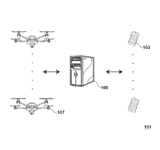
[0004] FIG. 1 is an illustration of an embodiment of a system for summoning
drones
for the capture of digital media.
SUMMARY OF THE DISCLOSURE
[0005] In one aspect, a method is provided for sending a drone to a user on
request.
The method comprises providing software, an instance of which is installed on
a plurality
of mobile technology platforms, wherein each mobile technology platform is
associated
with a user and is equipped with a tangible, non-transient medium having an
instance of
the software installed therein, and wherein the software contains suitable
programming
instructions The programming instructions, when executed by a processor,
perform the
steps of (a) displaying, on a display associated with the mobile technology
platform, a
graphical user interface (GUI) having a user selectable object displayed
thereon, (b)
determining when the user selectable object has been selected by the user, and
(c) when
the user selectable object has been selected by the user, (i) obtaining a
target location
(such as, for example, the current location of the user as determined, for
example, via the
location awareness capabilities of the user's mobile technology platfoun), and
(ii)
transmitting a request for a drone, wherein the request includes the target
location. The
method further comprises receiving, from one of the plurality of mobile
technology
platforms, a transmitted request for a drone, and dispatching a drone to fly
over the target
location set forth in the request. In a preferred embodiment, the method also
includes the
step of capturing digital media from the target location from one or more
devices
disposed on the drone.
[0006] In another aspect, a method is provided for requesting digital media
capture
by a drone. The method comprises obtaining a mobile technology platform
equipped
with a display and having a tangible, non-transient medium with an instance of
a software
program installed therein. The software program contains suitable programming
instructions which, when executed by a processor, perform the steps of (a)
displaying, on
the display, a graphical user interface (GUI) having a user selectable object
displayed
- 2 -
CA 02971254 2017-06-15
WO 2016/100601 PCT/US2015/066257
thereon, wherein the GUI includes a digital media control panel that allows
the user to
input digital media capture control commands from the mobile technology
platform to the
drone, (b) determining when the user selectable object has been selected by
the user, and
(c) when the user selectable object has been selected by the user, (i)
obtaining a target
location (such as, for example, the current location of the user as
determined, for
example, via the location awareness capabilities of the user's mobile
technology
platform), and (ii) transmitting a request for a drone, wherein the request
includes the
target location. The method further comprises selecting the selectable object,
and
inputting digital media capture control commands into the digital media
control panel.
[0007] In a further aspect, a system is provided for capturing digital
media. The
system comprises a fleet of drones, each of which, in the preferred
embodiment, is
preferably equipped to capture digital media related to a ground based target.
The system
further comprises a plurality of mobile technology platforms, each of which is
equipped
with (a) location awareness functionality, (b) a display, (c) a tangible, non-
transient
memory medium, and (d) an instance of a software program recorded in the
memory
medium. The software program contains suitable programming instructions which,
when
executed by a processor associated with the mobile technology platform, render
on the
display a graphic user interface (GUI) having a graphical object thereon
which, when
selected by the user, (i) deteitnines the current location of the user via the
location
awareness functionality, and (ii) transmits a request for a drone, said
request including
the determined current location of the user. The system further comprises a
controller
which receives requests for drones from the plurality of mobile technology
platforms and
directs a drone from the fleet of drones to the determined current location of
the user.
[0008] In still another aspect, a method is provided for performing an
appraisal on an
asset. The method comprises (a) providing a drone equipped with image capture
and
location awareness functionalities; (b) obtaining a set of comparable assets
to be used as a
basis for establishing the appraisal value of the asset; (c) repeating, until
n images have
been captured, where n > 1, the steps of
- 3 -
CA 02971254 2017-06-15
WO 2016/100601 PCT/US2015/066257
(i) transmitting to the drone a request to capture an image of a target asset
selected
from the group consisting of the asset and the comparable assets,
(ii) determining the current location of the drone with respect to a geofence
associated with the target asset, and
(iii) if the drone is within a distance d of the geofence associated with the
target
asset, then capturing the image, and otherwise denying the request; and (d)
using the n
images to determine an appraisal value of the asset.
[0009] In a further aspect, a method is provided for capturing images of an
asset. The
method comprises (a) providing a drone which is equipped with image capturing
and
location awareness functionalities; (b) receiving, from the drone, a request
to capture an
image of the asset using the software; (c) determining the current location of
the drone
with respect to a geofence associated with the asset; and (d) if the drone is
within a
distance d of the geofence associated with the asset, then granting the
request, and
otherwise denying the request.
DETAILED DESCRIPTION
[0010] Despite the aforementioned advances, several needs still exist in
the art for the
application of drone based imaging and, more generally, drone based capture of
digital
media. For example, in some applications, there is a need in the art to
obtain, on demand,
the drone based capture of digital media pertaining to a target of interest,
such as a
location or an event. There is further a need in the art for a means by which
a party
requesting drone based capture of digital media can control at least certain
parameters of
the digital media capture, and can define the target of the digital media
capture. These
and other needs may be met with the systems and methodologies disclosed
herein.
[0011] The systems, devices and methodologies disclosed herein may be
further
understood with reference to the particular, non-limiting embodiment depicted
in FIG. 1
of a system for summoning a drone for digital media capture. With reference
thereto, a
system 101 is provided which includes a plurality of mobile technology
platforms 103, a
server 105 and a fleet of drones 107. Each of the plurality of mobile
technology
- 4 -
platforms 103 has an internal memory device with an instance of a software
application
recorded therein.
100121 The software application is preferably equipped with suitable
features to allow
the user to capture digital media such as, for example, photos, videos and
sound files. In
a preferred embodiment, and in addition to the features and functionalities
described
herein, the software includes the features and functionality of the software
described U.S.
2013/0275505 (Gauglitz et al.), entitled "Systems and Methods for Event
Networking
and Media Sharing", U.S. 20130117146 (Gauglitz), entitled "System and Methods
for
Event Networking, Media Sharing, and Product Creation", and U.S. 62/048,506,
entitled
"Systems And Methodologies For Validating The Correspondence Between An Image
And An Asset". The
software may be implemented in various forms including, for example, as a
distributed
application, or as a client-server application.
[0013] In a preferred embodiment, the software, when launched on a mobile
technology platform on which an instance of the software is installed, renders
a suitable
graphical object on the display of the host device. This object may be, for
example, an
icon, a button, a tab, a picture, or any other suitable, user-selectable
object, although in an
especially preferred embodiment, it is an icon with the associated text field
"Drone Me!"
The object is preferably incorporated into the graphical user interface (GUI)
of image,
video and/or audio capture software installed on the host device, to provide
the user with
a further option for capturing those types of media.
[0014] In a preferred embodiment, selection of the graphical object by
the user causes
the transmission of a drone request to the server 105. This request preferably
includes the
current location of the user as may be determined, for example, by native
location
awareness software installed on the host device or by other suitable means.
100151 Upon receipt of a drone request, the server 105 utilizes a
suitable algorithm to
determine which drone, in the fleet of drones 107, to dispatch to the user's
location.
Various factors may be considered in this determination including, for
example, the
availability of a given drone, the current location of the drone with respect
to the target,
- 5 -
Date Recue/Date Received 2020-11-09
CA 02971254 2017-06-15
WO 2016/100601 PCT/US2015/066257
the flight path required for a drone to travel from its current location to
the target, the
length of such flight path and the time required for the drone to traverse it,
atmospheric
conditions (including, for example, wind speed and wind direction), and other
such
factors.
[0016] Upon selection of a suitable drone, the server provides sufficient
instructions
for the drone to proceed to the target destination These instructions may
include, for
example, location information about the target (such as, for example, the
current location
of the mobile technology platform included in the drone request).
[0017] In some embodiments, as the drone approaches the target, it may cede
at least
partial control of its operations to the mobile technology platform from which
the drone
request was sent. This may occur, for example, when the drone reaches a
predetermined
distance from the target, or when the drone enters a geofence (for example,
one
associated with the mobile technology platform, or one designated by the
server).
[0018] For example, in some embodiments of the systems and methodologies
disclosed herein, upon approaching the target location, the drone may allow
the user of
the mobile technology platform to assume at least partial control over the
capture of
digital media by the drone. In such embodiments, the GUI may include a digital
media
control panel that allows the user to input digital media capture control
commands from
the mobile technology platform to the drone. These digital media capture
control
commands may include, for example, commands which specify the type of digital
media
to be captured by the drone, when or how frequently such digital media is to
be captured,
the location of a target to be imaged, a set of coordinates or geofence (which
may be a
user defined geofence) which specifies the location of the target, the shutter
speed or
exposure settings to be used by a drone camera in acquiring images or video
footage, the
lens or camera to be used during imaging (this may be an actual lens, or a
virtual lens
which produces a desired optical effect), or target information obtained, for
example,
from a target painter, which may be associated with the user and, in some
embodiments,
may be incorporated into the mobile technology platform.
- 6 -
CA 02971254 2017-06-15
WO 2016/100601 PCT/US2015/066257
100191 In some embodiments of the systems and methodologies disclosed
herein,
upon approaching the target location, the drone may allow the user of the
mobile
technology platform to assume at least partial control over the flight of the
drone,
especially when it is approaching sufficient proximity to the target location
to allow for
the capture of digital media. In such embodiments, the GUI may be equipped
with a
flight control panel that allows the user to input flight control commands
from the mobile
technology platform to the drone These flight control commands include
commands
which specify a portion of the flight path to be taken by the drone during
digital media
capture. In some embodiments, the GUI may also be configured to allow the user
to
enter or adjust other flight control parameters, such as the altitude, speed
or trajectory of
the drone. For safety or security reasons, the drone may be equipped with a
database of
allowable commands, such that any flight control command input by the user
which is
not an allowable command or would put the drone or members of the public in
peril may
be disregarded by the drone.
100201 As an example of the foregoing, in some embodiments, a fleet of
drones may
be made available at an event venue. Attendees at the event may be given the
ability to
assume control over a particular drone in the fleet for a period of time. This
may occur as
a result of the attendee purchasing drone time, receiving it as a
complimentary gift, or by
other means. During the time that the attendee has control over the drone, the
user may
utilize the drone to capture digital media of the event, and the digital media
may be
associated with the user and/or event in the manner described, for example, in
U.S.
62/048,506 (Gauglitz), entitled "Systems And Methodologies For Validating The
Correspondence Between An Image And An Asset", and in PCT/US15/49488, which
has
the same inventor and title. The user may have only partial control over the
drone during
this time. For example, the user may be able to control certain parameters of
the drone's
flight path, but may be locked out of adjusting the altitude of the drone.
When the drone
is not being utilized by an attendee, it may return to a home, base for
refueling or
recharging, or may hover over the event until another attendee takes control
over it. In
this way, control of the drone may be essentially passed off from one attendee
to another.
- 7 -
CA 02971254 2017-06-15
WO 2016/100601 PCT/US2015/066257
[0021] In some embodiments of the systems and methodologies defined herein,
a
drone may be equipped with suitable intelligence so that it can determine the
most
efficient flight path to canvas an event (for example, for digital media
capture purposes).
This may occur through software and/or hardware installed on the drone itself,
and/or
through suitable communications between the drone and one or more computers or
computer networks This intelligence may be adapted to permit the drone to
recalculate
its flight path due to detours or interruptions (as may occur, for example, if
an individual
temporarily assumes control over the drone in the manner described herein).
[0022] In some embodiments, the systems and methodologies disclosed herein
may
allow the user to enter information which specifies the general purpose for
which use of
the drone is being requested. This information may then be utilized to adjust
various
parameters controlling the drone to settings that are likely to be most
conducive to the
end use. For example, if the drone is to be used for capturing images or video
of real
estate, the drone may adopt one or more predefined flight patterns about a
location or
geofence that are most likely to result in quality image or video capture.
[0023] The systems and methodologies disclosed herein may be utilized in
combination with other systems and methodologies which include the capture of
digital
media as a step thereof, with understandable modifications made to account for
the use of
a drone in capturing the digital media. For example, these systems and
methodologies
may be utilized as a component of the systems and methodologies disclosed in
U.S.
62/048,506 (Gauglitz), entitled "Systems And Methodologies For Validating The
Correspondence Between An Image And An Asset", and in PCT/US15/49488, which
has
the same inventor and title. The '506 application and the '488 application
disclose
systems and methodologies for ensuring that an image captured of an asset
(such as a
home) correspond to the actual asset, and are of recent vintage. The systems,
methodologies and software disclosed therein for accomplishing this objective
may be
extended in a straight forward manner to the use of drones in capturing the
images of an
asset.
- 8 -
CA 02971254 2017-06-15
WO 2016/100601 PCT/US2015/066257
[0024] By way of illustration, a first entity requiring recent images of a
series of
properties (for insurance purposes, for example) may contact a second entity
which has
contracted with the first entity to provide such images upon demand. The
second entity
may own or rent a fleet of drones, or may have a business relationship with
another party
that does so. Upon receipt of the imaging request, the second entity may
dispatch one or
more drones to the location (or locations) of the property (or properties) to
be imaged.
[0025] The drones in such an embodiment (or a device controlling them) may
be
equipped with suitable software that prevents the acquisition of digital media
until the
drone is in sufficient proximity of a target asset. Such proximity may be
determined, for
example, by ascertaining the proximity of the drone to a geofence associated
with the
asset. In particular, digital media capture by the drone may be prevented by
such
software until the drone has entered a geofence associated with the target
asset.
[0026] In other embodiments, the digital media may be captured by the
drone, and
then subject to validation later for possible association with an asset. In
such an
embodiment, temporal and locative data associated with the captured digital
media may
be used in determining whether the digital media should be associated with a
target asset.
In some embodiments, the identification of the drone that captured the digital
media may
be embedded in metadata or other data associated with the captured media.
[0027] In some embodiments, one or more beacons may be disposed at, or in
proximity to, a target for the purposes of establishing a geofence which may
be used, for
example, to determine where digital media should be collected by a drone
(e.g., through
geofence entry). By way of example, if images are desired of the outer
structure
immediately adjacent to a particular room in a house (for example, to
determine the
extent of structural damages for insurance purposes), a beacon may be placed
in the room
and used to define a suitable geofence so that the drone will focus its
imaging efforts on
the appropriate portion of a house.
[0028] In some embodiments, suitable software may be provided to control
the
collection of digital media by a drone in accordance with a predetermined
formula. Such
software may be disposed on a drone itself or on another deice such as, for
example, a
- 9 -
CA 02971254 2017-06-15
WO 2016/100601 PCT/US2015/066257
mobile technology platform, computer, server or other suitable device which is
in
communication with the drone and which exerts at least partial control over
the drone's
flight path.
[0029] For example, when a drone is utilized to image houses, such software
may
determine a set of optimal locations (e.g., sets of 2-dimensional or 3-
dimensional
coordinates) at which images are to be captured, the optimal attitude (e.g.,
pitch, yaw and
roll) of the drone for each image, and the most efficient flight path for the
drone to follow
so as to collect the images in the least amount of time or with the least
expenditure of
energy. The foregoing may depend on such factors as, for example, current
weather
conditions (such as, for example, wind speed and direction), the location of
the sun, and
the degree of clarity. The drone may then follow the prescribed flight path
and capture
images at the predetermined locations.
[0030] Of course, it will be appreciated that the foregoing method may be
utilized to
capture images of a set of assets. In such an embodiment, the software may
determine
the optimal overall flight path for the drone to be able to capture images of
all of the
assets subject to appropriate constraints such as, for example, available
fuel, time, and
consideration of restricted air space.
[0031] In some embodiments, a database of parameters (such as coordinates
for
imaging locations relative to a structure) may be maintained for houses or
other structures
of various sizes, number of levels, shapes and footprints. These parameters
may then be
utilized to control image capture.
[0032] The systems, methodologies and software applications described
herein may
also be extended in a straight forward manner to the systems, methodologies
and software
applications described in U.S. 2013/0275505 (Gauglitz et al.), entitled
"Systems and
Methods for Event Networking and Media Sharing", U.S. 20130117146 (Gauglitz),
entitled "System and Methods for Event Networking, Media Sharing, and Product
Creation". For example, the media sharing software disclosed therein may be
modified
to include the "Drone Me" functionality described herein, thus allowing a
spectator,
participant or attendee at an event to have an aerial image or video captured
of them.
- 10 -
CA 02971254 2017-06-15
WO 2016/100601 PCT/US2015/066257
[0033] In other embodiments, the software installed on a mobile technology
platform
associated with a spectator, participant or attendee at an event may be
utilized in the
manner described herein to at least partially control the flight or imaging
capture of a
drone. In such embodiments, a party may supply one or more drones for an
event, and a
spectator at the event who is equipped with a mobile technology platform
having the
foregoing software installed thereon may "rent" control of the drone for a
predetermined
period of time through submission of a request through the software.
[0034] While the above systems, methodologies and software have frequently
been
described specifically with respect to the capture of images of particular
types of assets
(such as, for example, houses or other assets), it will be appreciated that
these systems,
methodologies and software are more generally applicable to the collection of
various
types of digital media pertaining to various types of assets.
100351 It will be appreciated that the systems and methodologies disclosed
herein
extend beyond media capture. For example, these systems and methodologies may
be
utilized in the context of drone rentals, where a user may summon a drone for
a variety of
purposes. For example, in some embodiments of the systems and methodologies
disclosed herein, a fleet of drones may be equipped with suitable lighting,
electronic
signage, or audio transmission capabilities, and a user may summon a drone to
display
advertising, messages, or other content to an audience. For example, a user
may summon
a drone to pass over a birthday party while displaying "Happy Birthday!" and
playing
suitable music. In other embodiments, a user may summon a drone, and utilize
it to
deliver a package or item to a recipient. In still other embodiments, a user
may summon
a drone for emergency purposes such as, for example, locating a skier in an
avalanche.
[0036] In some embodiments of the systems and methodologies disclosed
herein,
multiple drones may be summoned to a crowded venue. In such instances, the
drones
may communicate with each other for collision avoidance purposes, and to plot
flight
paths for each individual drone that will prevent or reduce any interference
from any of
the other drones during media capture.
- 11 -
CA 02971254 2017-06-15
WO 2016/100601 PCT/US2015/066257
[0037] In some embodiments of the systems and methodologies disclosed
herein, a
request for a drone may include the selection of one or more parameters for
the flight
path of a drone. For example, a user may be able to select parameters that
will cause a
drone to hover or circle and indicated area or point for a predetermined
amount of time.
A user may also be able to select parameters that will cause a drone to
operate in stealth
mode. In such embodiments, the drone may operate in response to such a request
by
reducing or minimizing operational noise or by selecting a flight path that
will cause the
drone to be as unobtrusive as possible.
[0038] In some embodiments of the systems and methodologies disclosed
herein,
when a drone arrives at a destination, it may follow a user. This may be
achieved, for
example, by having a mobile technology platform associated with the user
update its
location periodically, and provide that updated information to the drone (this
may occur
through direct communication between the mobile technology platform and the
drone, or
indirectly by way of, for example, one or more servers).
[0039] Various mobile technology platforms may be utilized in the systems
and
methodologies disclosed herein. Preferably, these mobile technology platforms
are hand-
held devices such as smartphones which are equipped with a display, an
operating
system, a communications system and location awareness. Many current models of
such
devices weigh less than 6.5 ounces. However, it is to be understood that other
similar
devices may be used in some embodiments of the systems and methodologies
described
herein including, for example, laptop or tablet PCs.
[0040] The above description of the present invention is illustrative, and
is not
intended to be limiting. It will thus be appreciated that various additions,
substitutions
and modifications may be made to the above described embodiments without
departing
from the scope of the present invention. Accordingly, the scope of the present
invention
should be construed in reference to the appended claims. In these claims, it
will be
appreciated that the limitations set forth in any claim may be combined with
the
limitations set forth in any other claim (or claims) without departing from
the scope of
- 12 -
CA 02971254 2017-06-15
WO 2016/100601 PCT/US2015/066257
the present invention, unless the current specification specifically teaches
otherwise.
Thus, for example, the various limitations set forth in any dependent claim
may be
combined with the limitations set forth in any other dependent claim, whether
or not such
combination is explicitly called out in the present claims or specification.
- 13 -